Status |
Construction scheme (completed) |
Where |
To grade-separate the existing at-grade T-junction where the A26 Dromore Road, Banbridge meets the main A1. |
Total Length |
0.2 km / 0.2 miles |
Dates |
First proposed December 2003
Vesting Order signed 9 November 2006
Contract signed mid December 2007
Work began March 2008.
Junction partly opened to traffic early July 2009
Junction opened 14 Sep 2009 (one month behind schedule) |
Cost |
c£7.5m - is part of a £30m scheme to upgrade 4 junctions |
Photos |
See below |
See Also |
General area map
A1 on this site, including map |
The A26 Dromore Road is the principal access route in and out of Banbridge from the north (Belfast) direction on the A1. At this point the A1 passes the eastern edge of Banbridge. It meets the A1 at a T-junction where vehicles wishing to turn right onto the A1, or turn right off the A1 into Banbridge, must cross one or more carriageways. As with all at-grade junctions on the A1, this problem causes accidents and delays.
This project involves the construction of a bridge, roughly 50-100 metres south of the existing junction. A roundabout will then be built on the Banbridge Road connecting to a loop which will pass over the A1 and round to meet the southbound carriageway on the other side. According to Roads Service the loop will "adopt the minimum 40 metre radius". However, this tight geometry is not thought to present a risk since it is "isolated from the existing road network reducing the potential risks associated with the change in standards". The contractor is Amey Lagan.
The map below shows the current arrangement shown as the green/red roads, with the proposed bridge and link road shown in blue. (See alternative Roads Service map by clicking here.)

In November 2008, Roads Service released a leaflet to the press and public containing the following artist's impression of the junction:

Progress
26 Sep 2009: Despite visitors reporting to me that the junction was fully in use during August, this news story implies that it was not fully in use until 14 September. I can't verify either of these, so it shall have to remain uncertain! However, since the "official" opening is being given as 14 September, this means that the scheme was in fact completed one month behind schedule.
5 Sep 2009: The junction opened to traffic in early July, and is now complete and in use. At project start we anticipated completion in August, so it was completed approximately one month ahead of schedule.
23 June 2009: The Minister confirmed on Friday that the delay in opening the flyover is because the new junction did not fully pass its inspections. He said that there were ongoing "works arising out of a safety audit, and other snagging surveys". This means works had to be carried out due to the findings of a safety inspection, and works had to be carried out after defect identification ("snagging"). However, the flyover IS currently open to allow motorists travelling south on the A1 to exit the A1 and cross over into Banbridge, although it stll can't be used in the other direction for joining the A1. The scheme is nevertheless running ahead of schedule, so although this is a delay, we are still ahead of the original programme, which anticipated completion around August.
7 June 2009: The new junction remains unopened. There are unconfirmed rumours that the scheme has failed some sort of inspection. Judging by work that is currently underway shifting kerbing, this does not seem to be serious and seems to focus on the geometry of the new roundabout. Hopefully this problem, if it's true, will not delay opening significantly.
23 May 2009: Progress on this junction is so far advanced, that the junction appears largely completed. The central reservation has been closed up (pic 1), although the sliproads on the east side are not yet open. The bridge itself is looking completed (pic 2). Although completion is not due until August, it looks likely that it will be opened earlier than this, perhaps in June.
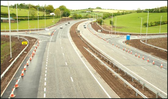
Pic 1: View north from the new bridge on 17 May 2009. The existing junction (on the left) has now become accessible to northbound traffic only, while the new southbound sliproads are on the right, completed but not yet opened. [Aubrey Dale]
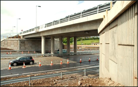
Pic 2: The new bridge itself, here seen looking west on 17 May 2009. [Aubrey Dale]
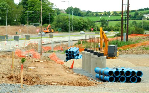
5 May 2009: Of the four flyovers/underpasses currently being built on the A1, this one seems to be the most advanced. The bridge looks completed, with even the railings in place, while the roundabout on the western side is open to traffic and the road across the bridge seems very well advanced. If the project is on schedule, the whole junction should be open by August this year.
16 Feb 2009: Since the last update, the beams for the new bridge have been added and the bridge deck has been begun. The approach ramps on each side are also taking shape and have even been surfaced on the Banbridge side.
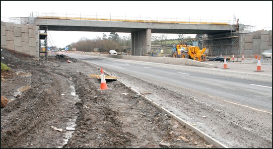
The beams have now been added to the bridge, as seen on 14 Feb 2009. [Aubrey Dale]
Looking west across the A1 towards the junction on the Banbridge side. The
ramp curving up to the left is part of the link over the bridge to the opposite carriageway.
Seen on 14 Feb 2009. [Aubrey Dale]
1 Jan 2009: Work is proceeding well on the scheme. The photograph below shows the new bridge seen from the south side about two weeks ago. The two bridge abutments and central pier appear to be nearing completion.
The flyover taking shape on 21 December 2008. [Aubrey Dale]
16 Nov 2008: Roads Service have released a leaflet containing details about this scheme, including an artist's impression of the junction (see above) and confirming that completion is due by Winter (ie late) 2009.
20 Jul 2008: The line of the new road (see map below) is now marked out and obvious at the site, and the pillars for the bridge on either side of the A1 are also in place. There is no sign as yet of the approach ramps that will be necessary to raise the road up to the level of the flyover. The photo below shows the view looking north on the east side. As well as the pillars for the flyover you can see the route of the new road curving round behind the digger to join the southbound carriageway.
View north towards the new bridge piers on the eastern side of the A1 on 20 July 2008.
[Aubrey Dale, used with permission]
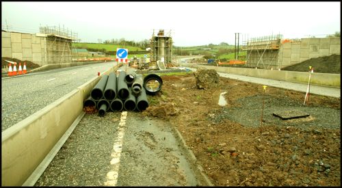
20 Mar 2008: According to site visitor Alan Mannis, work has begun with earthworks underway. As this is one of the busiest junctions on the A1, this scheme will be a significant safety improvement.
27 Sep 2007: According to Roads Service, work is due to get underway in April 2008. Some hedge removal has taken place already, ahead of the bird nesting season.
|
