|
|
Status
|
Construction scheme
(proposed) |
|
Where
|
To add
a direct link between the A21 Ballygowan
Road and the A21/A22 Comber Bypass -
currently it passes over it on a bridge. |
|
Total
Length
|
n/a |
|
Dates
|
Comber Bypass Phase 1
- 1960s
Comber Bypass Phase 2
- Oct 2003
Phase 3 included in
draft Ards and Down Area Plan - 2002
Ards and Down Area
Plan adopted - March 2009
No current plans to
construct the road (as of Aug 2009)
|
|
Cost
|
Unknown |
|
Photos
|
None as yet -
please contact me if you have any to
contribute. |
|
See
Also
|
Comber
Bypass Phase 2 on this site
Map
showing protected route - Planning
Service
Map
showing route on aerial photo -
Google Maps
|
The Comber Bypass was
built in two phases over thirty years apart and
connects the Belfast Road to the north west to
the Newtownards Road to the north east, and
passes round the south side of the town on the
line of the former railway line. Phase 1 (1960s)
connected the Belfast Road to the Killinchy Road
while phase 2 (2003) connected the Killinchy
Road to the Newtownards Road. Because of the
hilly nature of Comber, the bypass passes over
Mill Street and under the A21 Ballygowan Road. A
short link road connects Mill Street to a
T-junction with the Belfast Road. This sketch
map illustrates the current arrangement:
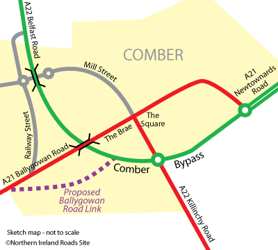
The problem
with this is that there is no convenient
connection between the A21 Ballygowan Road and
the Bypass. Quite a lot of traffic approaches
from this direction and must either drive along
Railway Street (a residential area with speed
bumps) to the T-junction to the north, or else
continue to The Square in the centre of town via
The Brae or Mill Street (defeating the purpose
of a bypass). To make matters worse both The
Brae and Mill Street are narrow streets and in
places are not wide enough for two vehicles to
easily pass each other.
The plan, sometimes referred to as
"Phase 3" of the Comber Bypass, would connect
the Comber Bypass directly to the Ballygowan
Road, by re-aligning Ballygowan Road to the
south, starting at the current town limits, and
joining the Comber Bypass just west of the
existing Killinchy Road roundabout, probably
with another roundabout. The land that would be
needed for this scheme is largely undeveloped
and some of the land is owned by Roads Service.
The land in question is obvious
from the air. However, Roads Service are
not in any hurry to provide this link and
currently there are no plans to proceed in the
near future.
Progress
31
Aug 2009. The Ards and Down Area Plan
2015 was finally adopted in March 2009, seven
years after the draft was released. It reaffirms
the intention to preserve land for this scheme:
"This road line continues to be protected as
a means of permitting traffic on the
Ballygowan Road to join the strategic road
network (Comber By-pass) and to get to/from
more strategic destinations. At present
Ballygowan Road traffic has to either use
Railway Street or Bridge Street, Newtownards
Road and Killinchy Road in order to gain
access to the Comber By-pass. It has
been protected for a considerable number of
years and previous development has been
designed to accommodate it. Some land has
already been purchased and discussions on
other planning applications have taken account
of it. It
represents the last opportunity to connect the
last remaining main route into Comber into the
strategic road network."
|
