|
|
Status
|
Construction scheme
(proposed) |
|
Where
|
To
build a road connecting the M1 at
junction 8 to the A3 Moira Road / A520
Knockmore Road, Lisburn |
|
Total
Length
|
1.6 km / 1.0 miles
|
|
Dates
|
Proposed in Belfast
Metropolitan Area Plan - Nov 2004
Pre-applicaiton notice submitted by
Neptune Carleton - Sep 2017
No work carried out
as of Oct 2017
Planning approval granted - Apr 2021 -
but subsequently "called in" by DFI
Construction was to
have to begun early 2022 and lasted
about 18 months (as of Apr 2021)
Planning approval for
road granted by DFI - 16 Aug 2023
Developer has little incentive to begin
work as of Aug 2023
|
|
Cost
|
£12m - will be
funded by private developers. |
|
See
Also
|
General
area
map - Google Maps
Official
BMAP
web page on proposal
|
Click
here to jump straight down to updates
for this scheme.
Lisburn became a city in 2002, and continues to
see rapid growth not only as a residential
region of the Belfast Metropolitan Area, but
also as an employment centre in its own right.
In west Lisburn, Knockmore Road and Prince
William Road were opened in 1978 to allow the
growth of this part of the city, and it is now
largely developed. The 2004 "Belfast
Metropolitan Area Plan 2015" (BMAP) allocated a
large area of land (about a square kilometre)
south of A3 Moira Road and north of the M1 for
industry and commerce, though as of 2020 housing
seems to feature more heavily in the development
plans than anticipated by BMAP. This area is
currently rural, traversed by the Blaris Road.
The BMAP has included provision of a link
between the M1 and Knockmore Road, which must be
provided by private developers wishing to
develop this land. The proposal is designated
"LC 17/01". The required junction on the M1
itself was built
in 2003 by the developers of the Sprucefield
area. This map shows the proposed route of the
rest of Knockmore Link in red:
The proposed road will begin beside the
Sprucefield park-and-ride at junction 8, and
travel across the relatively flat land of the
Lagan Valley to the existing Moira Road /
Knockmore Road junction. This will be of
enormous benefit to the city, as it would mean
the bulk of traffic heading to the west of the
city would no longer have to go via the city
centre along Hillsborough Road as it does at
present. The road requires the
construction of a new bridge overwill the River
Lagan, which be a substantial structure.
The only road it would meet would be Blaris
Road.
The new road will be built to four-lane
single-carriageway standard (although the short
stretch closest to the M1 will be a
dual-carriageway). It will probably carry an
A-classification, either continuing the A520
number of Knockmore Road, which would be its
continuation to the north, or that of the A101
Sprucefield Link Road, which would be its
continuation to the south.
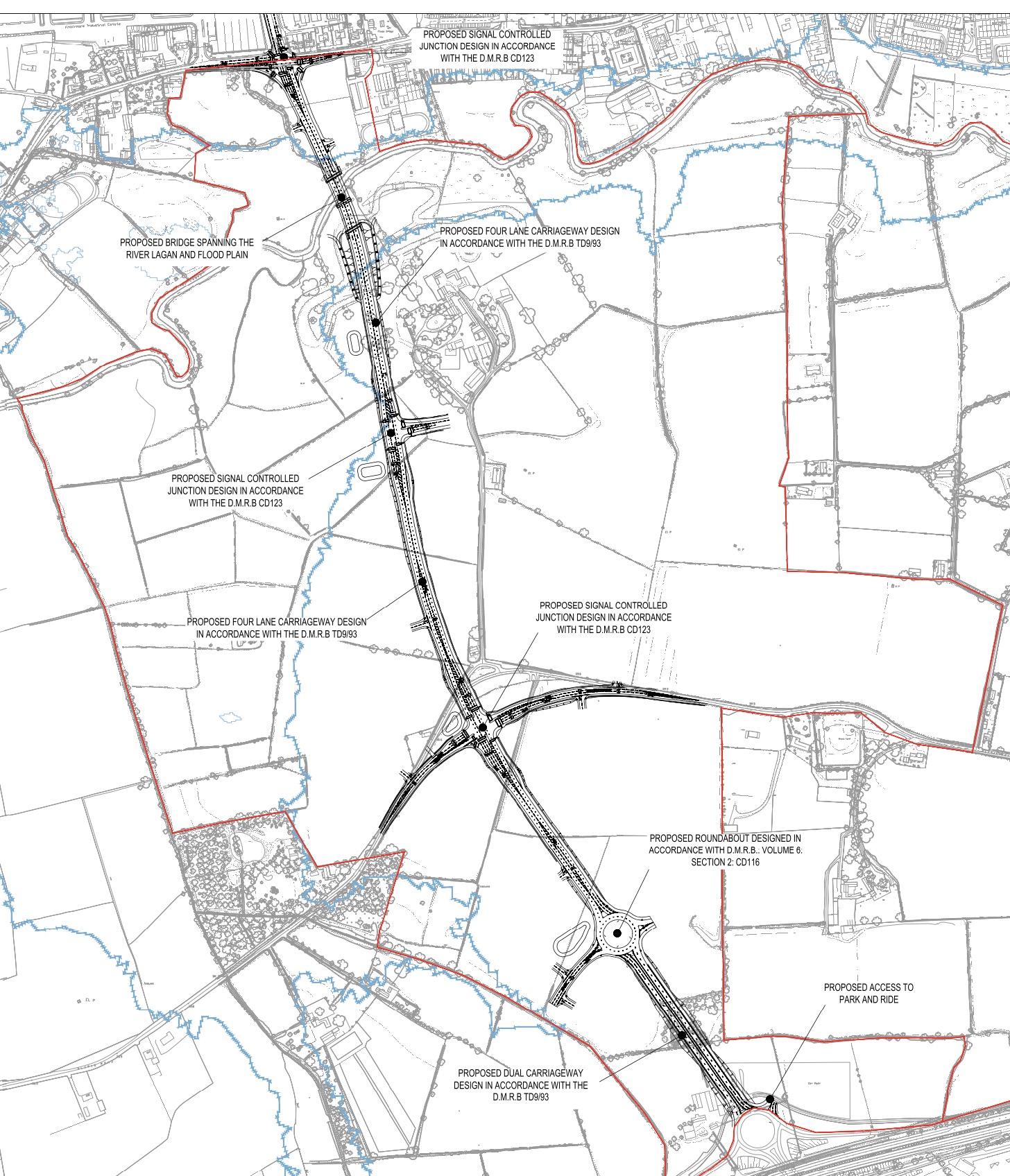
The following map shows the proposed design of
the road as of September 2018. This is the
design that received planning permission in
2021. The terminus at the north (top) end of the
map is the A3 Moira Road/A520 Knockmore Road
junction, while the terminus at the south
(bottom) end is the M1 motorway junction 8.
Updates
22 Oct 2025:
In the update two years ago (Aug 2023) I said
there was a disagreement between DFI, the
council and the developer about what exactly
should be build on the land here. This meant
that, although the road itself had planning
permission, there was no incentive for the
developer to build it (it is to be privately
built). But in a Written Answer (AQO
2501/22-27) answered two weeks ago the DFI
Minister Liz McKimmin said "A planning
application has recently been lodged for a
significant mixed-use development on the lands
between the existing M1 Junction 8 / A101
roundabout and Moira Road / Knockmore Road
junction. The approved Knockmore Link Road is
to be provided in support of this large-scale
development." It must be borne in mind
that planning processes can take a long time
here, but this nonetheless is a step closer to
construction.
1 Dec 2023:
DFI Roads are clearly planning ahead for the
provision of this road – when it eventually
happens – as its construction will impact the
existing entrance to Sprucefield Park-and-Ride.
You can see the existing arrangement in the
aerial view below. The current entrance will be
subsumed by the Knockmore Link, so DFI have
applied for permission to create a fifth exit on
the roundabout (hurrah, another five-arm
roundabout...). The application
went in about 18 months ago, but has been
updated recently to the design shown below. The
new arrangement will replace two blocks of
parking spaces, so the application also includes
an extension of the park-and-ride to the east to
compensate with another parking bay. A small
number of spaces will also be added where the
current bus stop is. The overall result will be
a small increase in total spaces (7 more). The
design will also cut across the route of the new
Blaris Greenway, and the design indicates a
location for a crossing point but no detail on
what the exact arrangement will be. Some kind of
controlled crossing would be best, if it can be
provided, and especially so where it will cross
the proposed Knockmore Link to the west. The
ideal solution might be to take the Greenway
down into a subway or carry it over both routes
on a bridge. There's still no indication that
the private developer will build the road any
time soon, as it's embroiled in a disagreement
over the type of land use to be allowed in the
area by the upcoming Regional Development
Strategy.
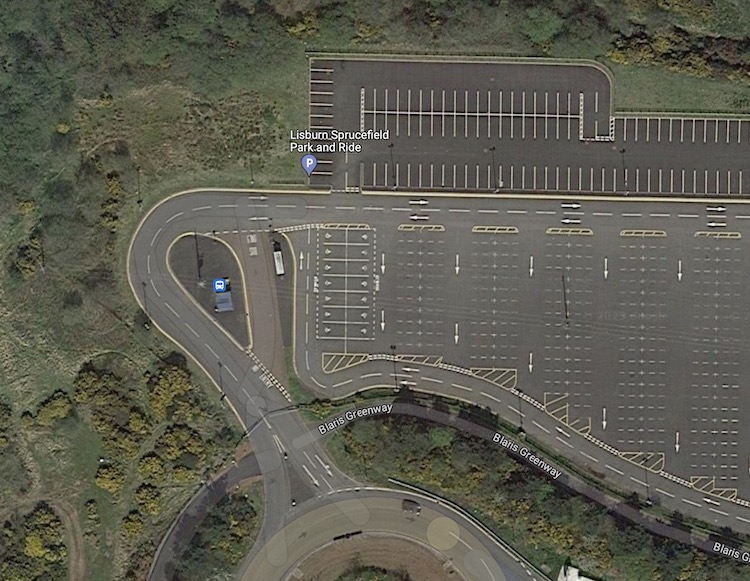
Current arrangement at Sprucefield Park-and-Ride
at M1 junction 8. The existing entrance on the
left follows the line of the proposed Knockmore
Link Road. [Google Maps] saved 1 Dec 2023

Proposed arrangement at the site, showing the
new entrance which replaces two sets of parking
bays and adds a fifth arm to the roundabout.
[DFI document dated 27 Sep 2023]
30 Aug 2023:
After more than two years of delay, DFI finally
granted
permission for the road on 16 August 2023.
They had been delaying the project since they
"called in" the decision to approve permission
in April 2021. However, DFI also refused
permission for any of the associated
developments which the new road is intended to
serve, meaning that the developer has little
incentive to actually build the road. I think
part of what is going on is that DFI and the
local councils are working on new transport
plans and they are reluctant to prejudge those.
There is also disagreement between DFI, the
council and the developer about what exactly
should be build on the land here. Since the
announcement was made two weeks ago it seems
that further conversations have been taking
place between the local council and DFI, so we
will see if that yields any changes. As things
stand today, there is little prospect of the
road being built in the near future.
8 Feb 2023: We
are now over a year since the Department for
Infrastructure decided to "call in" the decision
to approve planning permission for this road in
April 2021 (see previous update). The developer
and local political representatives have
recently expressed considerable frustration at
the length of time this has gone on without a
decision. From their perspective, DFI explained
recently in an article
in the News Letter that "The department
[DFI] requested further environmental
information for the link road application in
December 2022. Once received, this information
will be considered, publicised and consulted
upon in accordance with statutory procedures.
Thereafter, departmental officials will
progress the planning application to the point
where it is ready for a decision to be made.
At that point, and in the absence of
ministers, the department will take account of
the prevailing decision making legislation
when considering if a decision can be made."
Fundamentally, the issue seems to be that DFI
see a potential conflict with the Regional
Development Strategy 2035, though I have not
seen spelled out what the conflict actually is,
other than the fact that it appears to be
specifically to do with the road rather than the
associated housing developments. While due
process has to be followed, I do think
commercial developers are entitled to expect
such due process to be carried in a timely
manner. Sitting on this decision for over a year
now, and especially only asking for additional
information after 11 months, does appear
excessive. There is currently no indication when
we might expect a decision to be made or work to
commence.
16 Jan 2022:
With work due to commence on this road in the
near future, the timeline has been thrown into
doubt by the decision
of the Department for Infrastructure to "call
in" the planning application on 4 Jan 2022.
Although the scheme (and the wider development
proposals for the land) was granted planning
permission by Lisburn and Castlereagh Council in
April, DFI do have the right to "call in" major
applications if they feel there is a need to
consider it at a regional level. In this case
they have said that the decision was due to the
"potential conflict with the Regional
Development Strategy 2035, the local
development plan for the area... the draft
Belfast Metropolitan Area Plan 2015, regional
planning policy contained within the Strategic
Planning Policy Statement and Planning Policy
Statements and the potential for the proposed
development to impact on the implementation of
the plan-led system". The scope of this
web site is the road link, so much of this
project falls outside my remit, but this is
fairly comprehensive reasoning so we shall have
to wait and see what happens next. For its part,
the developer Neptune Carleton LLP is extremely
unhappy, not least because it has taken DFI
eight months to "call in" the planning
application after permission was approved. Their
director, Patrick Heffron, said
"We have waited eight months now for a
response from DfI and have heard nothing of
note. We recently asked to meet the Minister
to seek an update and express concern at the
delay. Remarkably, Minister Mallon resisted a
meeting and could not even offer any
indication as to when DfI will release their
block on the applications." Whatever
happens, it now seems unlikely that work will
commence in 2022 as hoped. With thanks to Gavin
Bamford for flagging this development to me.
15 Apr 2021:
Lisburn and Castlereagh Council this week
approved planning permission for a major £250m
development of 1300 units of housing plus
commercial developments around the Blaris area
of Lisburn, by Neptune Cartleton. Although the
proposal is much wider in scope than just the
Knockmore Link road, that is the interest of
this web site and where I am focusing. The
planning reference is LA05/2018/1155/F. According
to the Belfast
Telegraph, the Knockmore Link road will be
provided in full early on in the development, at
a cost of £12m. The developer is anticipating
completion of the road by Summer 2023 which,
assuming an 18-month construction period, would
require work to begin at the start of 2022 which
is ambitious but plausible. Further up this page
I have added an image showing the plan for the
new road. It will be a substantial road with two
lanes in each direction and a combined
foot/cycleway on the eastern side. It will be
built mostly as a four-lane single-carriageway,
but the southernmost 300 metres, approaching the
junction with the M1, will be built as a
dual-carriageway. It will also require a
reconfiguration of the Park-and-Ride site at M1
j8, including an additional arm off the
roundabout. Along its 1.6 km length, the new
road will feature one roundabout and two
signalised junctions, with several additional
priority T-junctions. At its northern end, the
existing signalised junction between A520
Knockmore Road and A3 Moira Road will be
upgraded to become a signalised crossroads. The
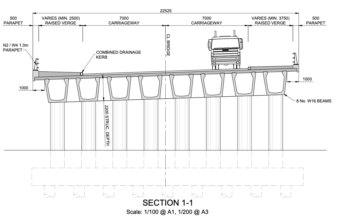
most substantial structure will be a bridge over
the River Lagan and its floodplain which will be
built as a two-span concrete beam bridge, with
each span being 37 metres in length and
consisting of eight parallel beams. The deck
will be built with a slight camber due to the
road following a gentle curve as it crosses the
bridge. See pictures below.
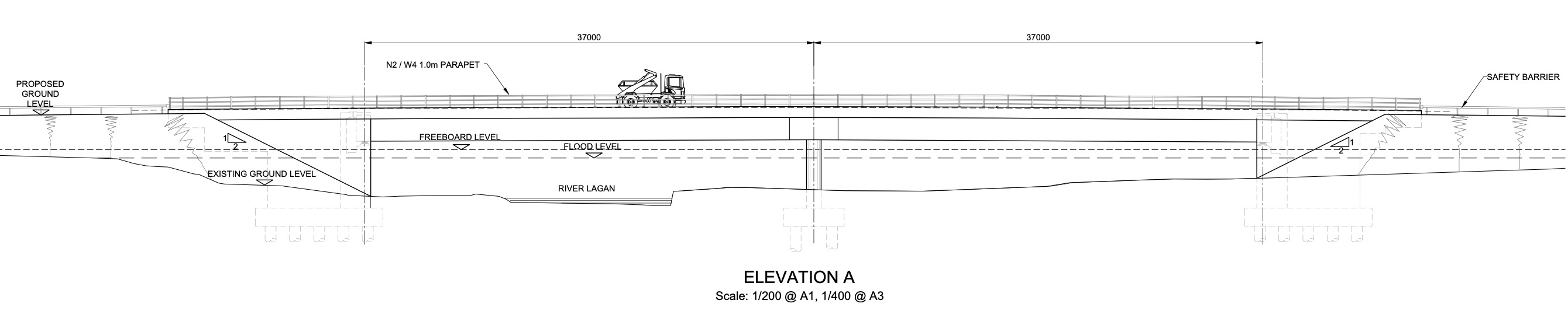
Elevation of the proposed bridge over the Lagan,
as of 2017 [Neptune Carleton].
Section of the proposed bridge over the Lagan,
showing the eight beams and the slight camber
[Neptune Carleton].
24 Oct 2017: A
private developer, Neptune
Carleton, has submitted a "pre-application
notice" for the development of approximately
1300 homes at Blaris, including construction of
the Knockmore Link (see news
report). A public consultation took place
in Lisburn in late September, though
unfortunately the material doesn't seem to have
been made available online. A "pre-application
notice" means that a planning application hasn't
yet been submitted, but that it is big enough
that the developer needs to be talking to the
authorities in good time to make sure they get
things as right as possible before beginning.
Assuming permission is granted (highly likely
since it's in the Belfast Metropolitan Area
Plan) it is likely that provision of the road
would be made a condition of planning approval.
It would be a substantial road, one mile long,
and would require a fairly substantial bridge
over the River Lagan at the north end. A road
like this could cost in the region of £5m, so it
would be a significant capital outlay for the
developer. Nevertheless, as it could take a
decade or more for all 1300 homes to be
completed, an important point is when
during this period the provision of the link
road is required. In other similar
cases around Northern Ireland where
provision of link roads have been conditions of
planning, roads have sat partially built for literally
years and years so hopefully in this case
the planners will appreciate this risk and will
insist on the completion of the link
road fairly early on in the development of the
site. One would not want a situation where the
northern part of the road is built early on to
provide access to the site, but the link to the
M1 taking place ten years down the line when the
site is almost fully developed.
23 Oct 2016:
The Minister was asked about this scheme via a Written
Answer (AQW 2008/16-21) and gave an answer
back in July. He said "The Council is aware
that the limited capital funding available to
my Department is directed towards the
maintenance and improvement of the Strategic
Road Network and that it is highly unlikely
that any financial contribution towards this
scheme could be justified at this time.
Currently when compared against demand for
other major road schemes it would not be a
high priority." So this suggests that,
unless Lisburn and Castlereagh Council can find
some way to partly or fully fund the scheme, it
is not going to happen. There has been no
further word on the previous Minister's comment
that she had asked her officials to see whether
it could be regarded as a "strategic" road,
which is not surprising because it was a highly
dubious suggestion since this road doesn't
fulfil any of the basic criteria of strategic
roads - which are roads whose primary purpose is
connecting together different regions of
Northern Ireland.
31 May 2016:
Every year the weeks leading up to Balmoral Show
usually bring about fresh discussion of this
scheme and this year has been no exception. The
official position is unchanged, namely that the
road will only be provided by private developers
as a condition of planning for developments in
west Lisburn. However, in recent months the new
Lisburn and Castlereagh Council has been
lobbying hard for the scheme to be built at
taxpayers’ expense (but with an option to recoup
the money later from developers) due to the
benefits it would bring to traffic by connecting
west Lisburn and the Maze site directly to the
M1 at Blaris. In a Council Facebook
post, one Councillor is quoted as saying “Our
independent economic forecasts suggest that
within four years the Blaris, Knockmore and
Maze Long Kesh plan zonings will create or
sustain upwards of 4,000 jobs involving 101
acres of development land. Therefore this new
road is critical to economic progress.”
In a Written Answer
in the Assembly on 23 February (AQO
9693/11-16), the then-DRD Minister
confirmed that she had met with Council members
to discuss the scheme and subsequently agreed to
“undertake a preliminary assessment of the
traffic impacts of the Knockmore Link, the
results of which should be available in March
2016” and added that “it is envisaged
that the results should provide objective
evidence for further discussion between
TransportNI and Lisburn and Castlereagh City
Council officers”. Although the official
position has not changed, this does suggest that
TransportNI is at the very least willing to
discuss the matter. Then, in the Assembly
in March, the DRD Minister said that "the
[financing] proposal that was put to the
Department at that time was a partnership
model, which would include all three partners
[TransportNI, Strategic Investment Board and
Lisburn & Castlereagh City Council]".
This seems quite plausible. She then added the
comment "Hence I asked my officials to
conduct a survey to see whether or not it
could be regarded as a strategic road."
Such a redefinition is presumably being
suggested because would allow access to more
funding sources, since TransportNI policy is to
limit their upgrades to strategic roads. However
it seems dubious to me that Knockmore Link could
be considered a strategic road. Strategic roads
are those which link together large population
centres, and Lisburn already has connections to
the both the A1 and M1, which are the nearest
strategic roads. Knockmore Link is clearly a
local distributor for the west Lisburn area
rather than a strategic road.
29 May 2015:
During a Ministerial
question time in Stormont on 19 May, the
DRD Minister was asked about this scheme, of
which nothing has happened in the two years
since the last update (see below). The scheme
periodically gets media attention around the
time of Balmoral Show as it would greatly assist
traffic getting from the M1 and A1 to the Maze
site. However, the Minister's reply was that the
DRD was quite insistent that public funds would
not be used to build the road, and that it could
only be provided by private developers who
wanted to develop land served by it (which
could, of course, include the developer of the
Maze site). He said "the Department is clear
that this project should be developer-led".
When pressed on whether this assessment could be
reviewed, the Minister responded that "there
are other strategic road issues in the area
[perhaps a reference to the A1/M1
Sprucefield Bypass proposal] that, with
collaboration and cooperation, could be
explored to the benefit of the whole area. I
am certainly open to that discussion to see
whether opportunities can be brought forward."
This sounds nice, but doesn't really mean
anything, so I would be fairly confident that
the current view that the road must be funded by
developers will remain, and that it is unlikely
to be built in the near future.
23 Jun 2013:
The Balmoral Show, which took place at the Maze
site a few weeks ago, has refocused public
attention on this scheme, which seems to
becoming inextricably linked with more general
transport arrangements for the site. Other
proposals include a new junction on the M1 west
of here. In a Question
for Written Answer two weeks ago, the
Minister was asked about the various road
proposals in the area. All he would say is that
"I am aware MLKDC [Maze/Long Kesh Development
Corporation] has a development plan setting
out proposals for road links to the M1
motorway. However, to date the MLKDC has not
made a planning application." The southern
half of the Knockmore Link in particular (M1
junction 8 to Blaris Road) would be a very
cheap, but highly beneficial, addition to Maze
access so the chances of it being implemented at
some point seem quite good.
11 Mar 2013:
There has been no further word on any part of
this road being provided. However, there was an
adjournment
debate in the Assembly last week about
road access to the Maze site, which touched on
this road proposal. An adjournment debate does
not make any decisions - it is simply an
opportunity for MLAs to discuss an issue of
concern. Sometimes a Minister is in attendance
to give the "official" line at the end of the
debate. In this case, a Junior Minister in the
OFMDFM department was in attendance. He said "The
Maze/Long Kesh Development Corporation was established
in September 2012 to regenerate the
site, and it is now responsible for its
regeneration, including the provision of
road infrastructure. Although the
regeneration plans are at a very early stage,
linking the site to the M1 is identified as a
high priority for the corporation, as it has
the potential to attract further private
sector investment to the site. However,
as Members will be aware, road infrastructure
is a complex process involving extensive
stakeholder engagement, business case
approval, design, planning permission,
procurement and construction, among many other
things." This suggests that, since my last
update in 2011, we at least now have a framework
in place through which this road could be fully
or partly built. He then went on to say "OFMDFM
allocated £21 million in the current CSR
period for a feasibility study, which is being
undertaken to consider the road
infrastructure options. The Maze/Long
Kesh Development Corporation is developing
a transport plan, which will include the
use of rail and other transport options, such
as a cycle network." The publication of
this 'transport plan' is likely to indicate
what, if any, parts of Knockmore Link might be
provided or indeed if there are other proposals.
18 Dec 2011:
According to one
of
these Written Answers from Stormont last
week, it is possible that part of the road may
be provided soon. It says that "a small section
of the Knockmore Link road is required by the
Maze regeneration site to help facilitate its
development." It does not explain what
this means. Since the only other road the
Knockmore Link would meet is Blaris Road, this
may mean providing a new link to Blaris Road,
since Blaris Road continues west to the Maze
regeneration site. If so, the "small section"
mentioned would be either (a) the stretch from
M1 j8 to Blaris Road, or (b) the stretch from
Knockmore Road to Blaris Road. Either way, it
would be another piece in the jigsaw of this
scheme - although the first of these would
probably be of more benefit to the public at
large. The Written Answer goes on to clarify
that "these
options [for road access to the Maze site]
will be subject to scheme development and
planning approval and the promoter of the site
will be expected to provide the road
infrastructure", ie confirming that
Roads Service will not be paying for it.
Photos
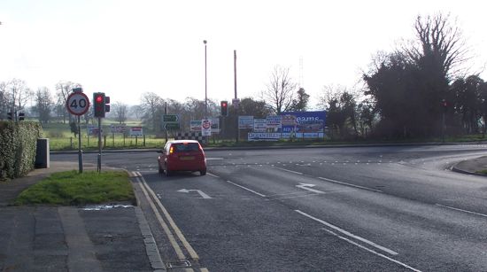
At the south end
of the scheme, this is the entrance to the
Park-and-Ride at M1 junction 8. It looks as if
the entrance to the facility has been designed
to eventually become the start of Knockmore Link
Road.
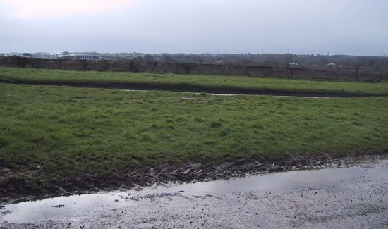
Looking east along Blaris Road, Lisburn, from
near the
point where the proposed Knockmore Link
Road would cross it left to right. Taken April
2006. [Wesley Johnston]
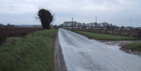
Looking south from Blaris Road, Lisburn, at the
point where the proposed Knockmore Link
Road would cross it. Looking along the route of
the proposed road towards M1 junction 8. Taken
April 2006. [Wesley Johnston]
Looking north from Blaris Road, Lisburn, at the
point where the proposed Knockmore Link
Road would cross it. Looking along the route of
the proposed road towards west Lisburn. Taken
April 2006. [Wesley Johnston]
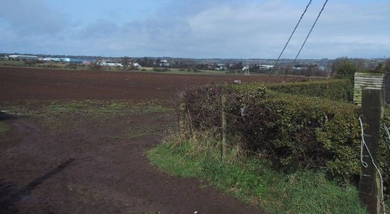
Looking south from the existing Knockmore Road,
Lisburn, where it meets the A3 Moira Road (left
to right ahead). The new road would terminate
here, turning it into a cross-roads. Taken Feb
2007. [Wesley Johnston]
|