Status |
Construction scheme (completed) |
Where |
Widen the citybound (hill) section of the M2 to 3 lanes between j4 and j2 (and to widen a short stretch of the countrybound section to 3 lanes through j2). |
Total Length |
5 km / 3 miles |
Dates |
This section of the M2 opened in 1966.
Widening project announced July 2004.
Preliminary works at Hightown Road bridge began Feb 2007.
Construction of rest of scheme began June 2007.
Hightown Road Bridge closed Oct 07 to 3 Sep 08 (except Dec 07).
Third lane opened to traffic 9 May 2009
Officially opened 9 June 2009 (2 months ahead of original programme)
|
Cost |
£29 million (funded through public/private partnership)
(note: cost sometimes given as £20m - unclear which is correct) |
Photos |
See below for photos and updates. |
See Also |
General area map.
Roads Service web site on scheme.
Roads Service information leaflet (PDF) including map.
M2 motorway on this site. |
This is a long page - be sure to scroll right down for maps, photos and updates.
Between junctions 2 and 4 of the M2 the motorway follows a steep slope, so the original 1960s designers added a crawler lane on the uphill section, so the M2 here is three lanes up the hill but only two lanes down hill. The down hill section is today one of the busiest in Northern Ireland, carrying 3170 vehicles per hour in the morning peak in 2004. A full 30% of these vehicles join the M2 at junction 4 (Sandyknowes) leading to the traffic on the M2 coming almost to a halt on most mornings as 1000 cars per hour try to merge with the 2100 already on the road.
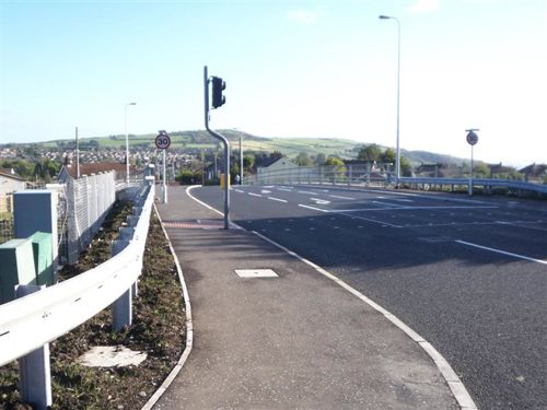
This scheme will widen the down hill section of the M2 to three lanes, the leftmost of which will be a direct continuation of the Sandyknowes onslip. This lane will continue straight through junction 2 (Greencastle) and then be dropped at junction 1 (Fortwilliam). It is hoped that this scheme will reduce congestion by moving the lane merge from Sandyknowes to Fortwilliam. It will also pave the way for modifications to Sandyknowes roundabout itself to allow some movements to be flow more freely.
The widened motorway will be contained entirely within the current road width by narrowing the central reservation and replacing embankments with retaining walls. It is predicted that the capacity for traffic flow on the hill section will have risen to 4630 vehicles per hour after this scheme.
In addition, the M2 uphill will be widened through the Greencastle interchange which currently features a lane drop / lane gain with only two lanes in each direction going through. The three lanes will be added in both directions here by removing the hard shoulder over a short distance. This means that the third lane that is gained at junction 1 (Fortwilliam) will continue straight through Greencastle and then be dropped at junction 4 (Sandyknowes). The scheme also includes the Crosskennan onslip plan, which is listed here separately and is now completed.
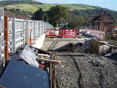
The widening project necessitates the demolition and reconstruction of three of the bridges over the M2 on this stretch, and the strengthening of a fourth (Bellevue Bridge). This map, based on Google Earth imagery, illustrates the locations of the bridges:
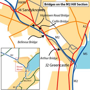
The works to be bridges include:
• Demolition and reconstruction of the current Arthur Bridge at Longlands and Collin Bridge in Glengormley. Temporary road bridges will be provided during this work. The environmental impact statement comments that as this is a 'gateway' to Belfast, the new bridges will be of a superior design compared to standard motorway bridges.
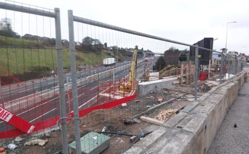
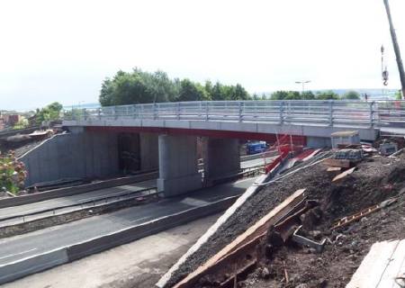
• Demolition and reconstruction of the current Hightown Road Bridge in Glengormley. A temporary footbridge will be provided, but cars will have to access the Hightown Road via Mallusk due to the lack of space for a temporary bridge. The new bridge will also be wider to allow for a turn-right lane into Mallusk, the lack of which currently causes traffic congestion at this spot. The demolition is due to take place early in 2008.
• The strengthening of Bellevue Bridge, which carries the Antrim Road. This bridge will not be rebuilt due to the many difficulties (and subsidence related litigation) that were involved when it was built for the first time. The M2 will therefore not have hard shoulders as it passes beneath the bridge.
Progress
10 June 2009: The scheme was officially opened yesterday by the Regional Development Minister Conor Murphy. He said "The £20million M2 improvements scheme represents a significant investment in the strategic road network, which I am sure will improve the efficiency of the transport system and help to strengthen the local economy, particularly at this difficult time. The scheme will greatly improve journey times for all traffic between Belfast, Antrim, the Port of Larne and Belfast International Airport, and, importantly, it will significantly improve journey time reliability on this route for the freight transport industry." He added a thanks to motorists: "I would like to formally thank road users, the surrounding community and all those affected by the works for their patience and co-operation throughout the construction period." Leo Martin, the Project Director for contractor HMC said "Delivering a major infrastructure scheme of this scale, ahead of schedule, takes a good deal of organising, hard work and good teamwork. Widening a busy section of motorway was particularly challenging and required careful planning to allow the works to progress. So let me thank our dedicated team of staff and subcontractors who worked tirelessly to successfully delivery of this project, ahead of programme." So far the scheme has been very well received and seems to have succeeded in the key aim of reducing the bottleneck at Sandyknowes (junction 4). Motorists leaving the city in the evening have also noted faster average speeds thanks to the third lane that now goes through the Greencastle interchange (junction 2). The only complaint I have heard from site visitors is that the surface on the northbound hill section seems to be rather bumpy/undulating.
Conor Murphy says that the scheme has been completed two months ahead of the original programmed completion date which was August 2009 (ie the date agreed with the contractor). He is not wrong in this, but it is worth noting that even in late 2008 the project completion date was being given as "March 2009" (for example, in one of these written answers from December 2008). This is not to take away, however, from the fact that the scheme has been completed ahead of the programme and seems to be a good job.
23 May 2009: The widened M2 will be officially opened on 9th June 2009, according to one of these Assembly written answers. The minister also said that actual work on the ground shoudl be completed a little before this: "later this month". So far reports have been fairly positive. Commuters who use the M2 have said that the M2 is flowing much better down the hill, and although traffic congestion has increased at York Street/Duncrue Street, this is not as bad as the congestion that previously existed at Sandyknowes. One commuter who gets the bus from Templepatrick to Belfast said that the bus no longer uses the bus lane on the Sandyknowes sliproads as it is now quicker for the bus to stay on the M2 and not attempt to bypass the jams via Sandyknowes. So all in all, a successful project. Well done to all involved.
8 May 2009: The third lane of the M2 will open for good tomorrow, Saturday, 9 May according to a press release. The hard shoulder will remain closed for the time being, but from drivers' perspectives this is the end of the scheme. The ancillary works on the scheme are due to be completed "later this month [May]". This is stated as being three months ahead of "the original programme" which we assume means the completion date stated in the contract with construction firm HMC. The minutes of a DRD board meeting in April says that the official opening is due to take place in early June, after what it describes as "slight slippage".
12 April 2009: The M2 is almost completed, and the Collin and Longlands bridges were fully opened yesterday. Up until now they have operated with a single lane under temporary traffic lights. This will mark the completion of this aspect of the scheme. Meanwhile, all three lanes of the upgraded M2 will be opened temporarily from Thursday 16 April until Sunday 19 April in order to test the new electronic motorway communication system. Once tested, the third lane will close again until the project is completed which is currently anticipated "by the end of April or early May" (press release).
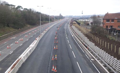
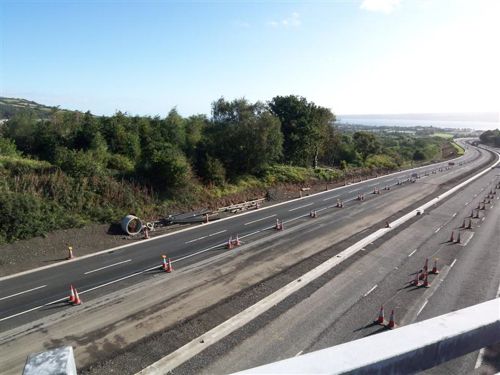
22 March 2009: The road is now almost completed, with just surfacing work remaining on the motorway itself, and some associated works on the local roads crossing the M2 on bridges. Citybound, the road appears completely finished. With the final layer of tarmac now laid, the road is looking very smart indeed. Although the third lane has yet to open, the new arrangement where the Sandyknowes onslip becomes the new lane is plain. The short stretch under Bellevue Bridge where the hard shoulder has been sacrified is warned well in advance by a huge "No hard shoulder 400m ahead" sign. Countrybound, the road is also completed (with two lanes open) although it seems that the final wearing course of tarmac has yet to be laid here. Nevertheless, final opening looks imminent and we should expect it within a few weeks. This will be a major relief to motorists.
9 March 2009: The scheme is now close to completion. When asked for the date that the third lanes will open on this stretch of the M2, the Minister said that the scheme "is presently programmed to be substantially complete by April this year, and that the third lane of the citybound carriageway of the M2, between Sandyknowes and Greencastle junctions, is expected to be opened to traffic before this date". This is not very precise, but does suggest that the opening is likely to be sometime in the next 6 weeks. This will be very welcome news to commuters who have endured the roadworks for almost two years. The results will be worth it. According to the Minister: "When the works are completed, this three lane urban motorway will provide a flow capacity that is approximately double the present traffic volume."
16 February 2009: The M2 hill section was closed citybound from Saturday night until Monday morning to allow some substantial surfacing work to take place. The result was unexpected traffic chaos on Sunday with traffic caught up in the jam for up to two hours. The fact that the M2 carries so much traffic even on a Sunday illustrates just how vital the M2 is to the infrastructure of Northern Ireland. Roads Service admitted that the congestion was worse than anticipated, with a spokesperson saying that he "didn't honestly expect the delays to be as significant as they have been. In that respect I will be reviewing everything we do." "This was a one-off to do essential surfacing to allow us to complete the improvement works we have underway." Drivers will be pleased to hear that there are no more planned daytime closures of the M2, the upgrade of which is scheduled to be completed within the next few weeks. See also this BBC video.
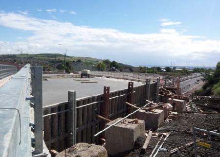
12 February 2009: The scheme is approaching completion, with the M2 carriageway and central barrier largely completed (pic 1). High level lighting has been installed along the central crash barrier and is now in use. In places the citybound carriageway drops several feet below the countrybound, presumably in order to achieve the necessary headroom under the bridges that are lower on their east side than the west. Only the final road surface and markings need to be added. Collin Bridge has become the second of the three reconstructed bridges to be completed (after Hightown) with just resurfacing required (pic 2). Arthur Bridge still has a bit of work to be done (pic 3), most noticeably the fact that the footpaths are almost two feet above the road level on the eastern side. Work to refurbish Bellevue Bridge is also progressing well, with the abutments and parapets both receiving a lot of attention (pic 4). With thanks to Owen Fulton for the pictures and information.
Pic 1: The upgraded M2 complete with barrier and mast lighting, seen
looking north from Arthur Bridge on 1 February 2009. [Owen Fulton]
Pic 2: Collin Bridge, largely completed and seen on 4 January 2009. [Owen Fulton]
Pic 3: Arthur Bridge in the final stages of construction on 1 February 2009. [Owen Fulton]
Pic 4: Parapet on Bellevue bridge being rebuilt, seen on 1 February 2009. [Owen Fulton]
16 December 2008: Work is proceeding very well on the scheme, with the second half of Arthur Bridge opening in November. According to a Stormont written answer from last week, the project is due to be completed in March 2009. The Minister claims that this is "five months ahead of the original programme". In September 2008 the completion date was being given as "Summer 2009", so on the face of it this is great news. However, it's worth noting that back in September 2007 the completion date was being given as "Spring 2009". Last month, Roads Service published a new leaflet providing a useful summary of the scheme.
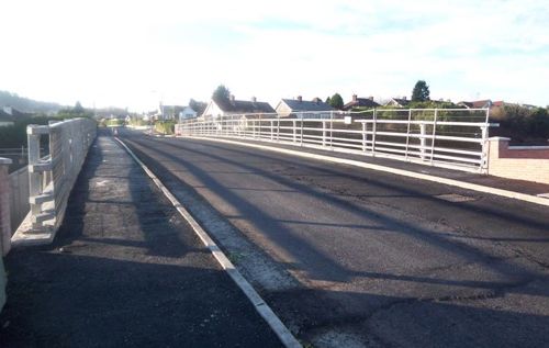
23 October 2008: Once again this progress report is with thanks to Owen Fulton who took these pictures on 5th October. The new Hightown Road bridge is now completed and open to traffic. The new bridge is wider, which has allowed the provision of a right-turn lane for traffic turning into Mallusk Road (pic 1). Work on Collin Bridge is continuing, with second half of the bridge close to completion (pic 2). Work on the Arthur Bridge is lagging further behind, while work on strengthening Bellevue Bridge seems to have been largely finished, and no major work now taking place there. Works on the series of bridges over the Shore Road, M5 and the railway line at Greencastle are also underway, with several bridges festooned with scaffolding. On the M2 motorway itself, the work to widen the road base on the whole route now seems complete, with vehicles running at either side of the site, while work to fit the new concrete central barrier is carried out (pic 3). Work has been underway for some time now to lower the citybound carriageway, most obviously under the Collin Bridge (pic 4). This may be to create extra headroom, or it may be to create a sufficent camber and horizontal alignment. It's unclear if it will be followed by a lowering of the countrybound carriageway. The new citybound sliproad at Greencastle (j2) is now complete and open to traffic. This sliproad originally formed a "lane gain", but will now become a normal merging sliproad. Currently, it looks as if there are about 9 months of work remaining, so the scheme is about 60% completed.
Pic 1: The completed Hightown Road bridge, seen from the south side on 5 Oct 2008. [Owen Fulton]
Pic 2: Collin Bridge nears completion, with the new bridge deck in place, 5 Oct 2008. [Owen Fulton]
Pic 3: The new central barrier (the thin grey line) being fitted near Belleveu Bridge, seen on 5 Oct 2008. This is slightly closer to the right side of the picture than the original crash barrier, illustrating how the road is being realigned to fit 6 lanes into the space of the original 5. [Owen Fulton]
Pic 4: Looking north (countybound) along the M2 from Collin Bridge on 5 Oct 2008, showing that the citybound carriageway (on the right) is now several feet lower than the other side. [Owen Fulton]
14 September 2008: Although the signage on the uphill section of the M2 says that completion is due in "November 2009", the press release issued when the Hightown Road bridge reopened asserts that completion "is presently expected to be completed in summer 2009". It's unclear which of these dates is currently true, but either way the project is now more than 50% completed.
31 August 2008: It was announced by Roads Service on Friday that the Hightown Road bridge over the M2 will reopen to traffic at 7.30pm on Wednesday 3rd September. This is at least three months ahead of schedule and will be very welcome news indeed for the residents of the area. Elsewhere on the site, works are continuing at all the work sites. Much progress is evident, although there is still over a year of work ahead before the project is completed.
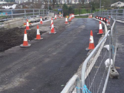
9 July 2008: Work is progressing well, with progress to report at various stages. This progress report is with thanks to Owen Fulton who took these pictures at the end of June and sent the information. The work to widen the M2 through the Greencastle interchance is progressing well with the works to convert the hard shoulder over the bridges into running lanes well advanced, and the widened carriageway well developed in the former grass verge. It now appears certain that the citybound onslip at Greencastle will become an ordinary sliproad merge rather than the lane-gain that it is at present. The widening work on the M2 motorway seems fairly complete from Greencastle as far as the Arthur Bridge, with the surface now in place, although work is less advanced further up the hill (see pic 1). At the Sandyknowes end new fencing along the sides of the motorway is now completed. At Authur Bridge (near Whitewell Road), half of the new bridge is now completed and open to traffic (one-way via traffic lights). See pic 2 below. The other half was demolished a few days ago to allow the remaining half to be rebuilt. The new bridge is as much as three feet higher in the centre than the old bridge. Some localised widening of Longlands Road approaching the bridge has also taken place. Works to strengthen Bellevue Bridge appears to be progressing, with no obvious changes visible from the road. Collin Bridge is at the same stage as Arthur Bridge, with one half now completed (about 7 weeks ago) and in use and work underway on the second half (see pic 3). Hightown Bridge is coming on well with the bridge deck now in place (see pic 4). This bridge is being rebuilt in one go, and is closed to vehicles. The new bridge is wider to allow a right-turn lane for vehicles wishing to enter Mallusk Road. The target is to have the bridge open by December 2008, and this seems easily achievable at this point. By the current estimated completion date of November 2009, there is still 16 months of work to go.
Pic 1: Widening works on the M2 looking countrybound from Collinbridge on 29 June 2008, with the somewhat chaotic lane markings. Still much work to be done at this point. [Owen Fulton]
Pic 2: Half of Arthur Bridge now completed over the M2 on 29 June 2008 [Owen Fulton].

Pic 3: The first completed half of Collin Bridge now in use on 29 June 2008. [Owen Fulton]
Pic 4: New bridge deck for Hightown Road bridge in place on 29 June 2008. [Owen Fulton]
For progress reports prior to March 2008, please visit the archive.
Problems?
My concern with this scheme is that by removing the Sandyknowes bottleneck vehicles will reach the M2/M3/Westlink interchange bottleneck much more quickly, thus causing much worse traffic jams on the foreshore section of the M2 than at present. My fear is that this scheme will simply shift the traffic jam downstream by 9km rather than removing it leading to no overall improvement in journey times. In a sense, Sandyknowes is the 'safety valve' that prevents worse congestion on the foreshore by keeping traffic flow down. Do not misunderstand me - this scheme is needed - but without further improvements at the M2/M3/Westlink junction it will not achieve its full potential.
Photos
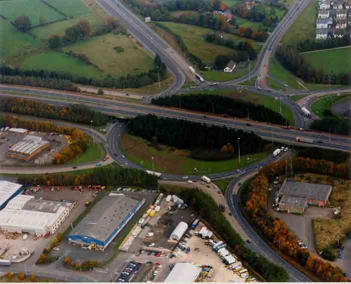
Sandyknowes roundabout, with the M2 going towards Belfast to the right. [Roads Service picture]
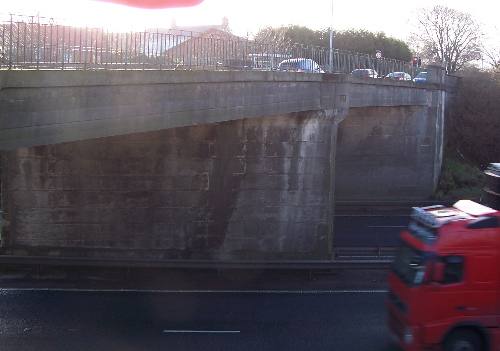
The Hightown Road bridge, the closest to Sandyknowes, will be demolished during 2007 (coincidentally, its 50th anniversary), before the rest of the scheme begins. The new bridge will be both longer, to accommodate the wider M2, and wider, to accommodate widening of the Hightown Road above. [Photo by Wesley Johnston]
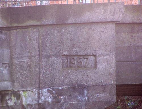
As one of the few motorway bridges to carry a date, the Hightown Road bridge itself confirms that it was built 9 years before the M2 opened beneath! Ironicially, it will be demolished in its 50th anniversary year. [Photo by Wesley Johnston]
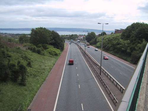
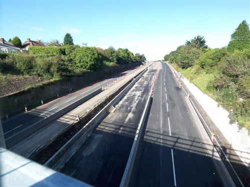
The M2 hill section at Bellevue Bridge, showing the current 2+3 lane arrangement. The third lane down hill will be added by narrowing the reservation and eating into the earth banks. This bridge is the only bridge not to be demolished and rebuilt as part of the scheme, and at 65 degrees is the one of the most oblique road bridges in Northern Ireland. [Photo by Wesley Johnston]
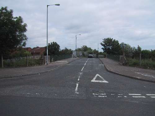
Arthur Bridge, seen here with the green railings, will be rebuilt. [Photo by Wesley Johnston]
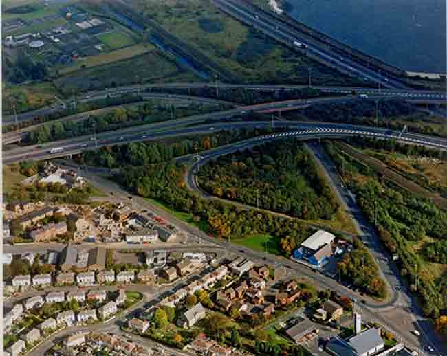
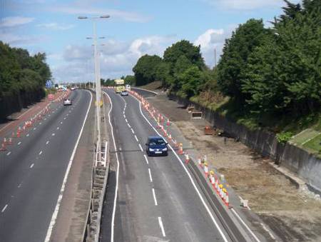
The end of the scheme is at Greencastle. The M2 runs left to right here and will be widened to three lanes in each direction through the interchange. [Roads Service picture] |
