|
|
Status
|
Construction scheme
(completed) |
|
Where
|
Construction
of a new bypass round the south of the
town connecting the main A20 (Belfast
road) to the A21 Comber Road and on to the
A20 Portaferry Road. |
|
Total
Length
|
2.7km / 1.8 miles |
|
Dates
|
Scheme proposed for many
years.
Funding announced 27
June 2005.
Construction originally
due to begin late 2006.
Work officially began 2
April 2008 and due to last 52 weeks.
Road opened to traffic
30 July 2009.
Most works completed by
mid September 2009 (5 months behind
schedule).
|
|
Cost
|
Varies from £7m to
£20.5m depending on which DRD
statement you read.
See note on costs
below.
Partly funded by
private developer of Castlebawn Retail
Park.
|
|
Photos
/ Map
|
See below |
|
See
Also
|
General
area map
Castlebawn
web site, including map of eastern part of
route.
See
below for map of western part of route.
Frederick
Street Link on this site.
|
Anyone who has tried to
travel though Newtownards will know that it
suffers from chronic traffic congestion due to the
fact that the only route into and out of the town
from the south is along the Comber Road. This
leads to tailbacks of over a mile every evening
for commuters trying to get into the town,
catching through traffic in its midst.
This much anticipated scheme will see a new road
built as an extension from Blair Mayne Road South
with a new roundabout at the Scrabo Road, then
south parallel but south of Jubilee Road and join
the Comber Road at a new roundabout. The road will
then run from here to terminate on Portaferry
Road. Another roundabout close to the airport will
give access to the new Castlebawn retail park.
This project is being partly funded by the
developers of the Castlebawn site. It will include
a 13-metre single span bridge across the canal.
The contract also includes the widening of Comber
Road between the new roundabout and the existing
Circular Road (ie past Jubilee Road, Lidl etc).
The scheme has been controversial: firstly, it
will involve the removal of the former railway
embankment which the Roads Service described as an
"eyesore" but which is valued by local residents
as a haven for wildlife. There is dispute over
whether badgers live here. Also, it will run very
close to some houses on Trasnagh Drive. Roads
Service have proposed various sound barriers, but
a local meeting that I attended revealed much
acrimony from residents. The roundabout at Scrabo
Road was an addition to the original plan, and may
have been to placate these residents.
Access to Jubilee Road will remain by traffic
lights onto Comber Road. There are no plans to
open up a western access. Residents of the
Westwinds estate will benefit from a pedestrian
crossing close to the estate, giving access across
the road to Jubilee Road.
History
I blogged about the history of this scheme going way
back to the 1970s here.
Note on Costs
The cost of this scheme is very uncertain. In an
assembly
written answer on 1 Feb 2008 Regional
Development Minister Conor Murphy stated that "the
total cost of the scheme is £20.5
million, of which Roads Service will
contribute £2.5million."
We can assume from this that £18m is being
contributed by the private developer, presumably
the Castlebawn developer. However in this
press statement 8 weeks later, Conor Murphy
says "It is anticipated that work on this 2.7km
scheme to link Portaferry Road, Comber Road and
Belfast Road will take approximately 12 months to
complete with a construction cost of £7million".
Clearly it refers to the same project, but no clue
is given to explain the wildly varying costs
between the two statements. This
press release, by the owners of the planned
Castlebawn Retail Park on 2 April 2008, gives the
cost as "£8million" with
their contribution being "almost
£5million". Sure enough, in an Assembly
written answer given in March 2009, the joke
was continued with the cost this time given as "£14
million"! And when the road finally
opened to traffic in July 2009, the cost had
reverted back to £7million.
Progress
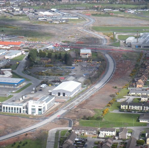
12 Oct 2009:
To cap off the project, below is a nice aerial
shot taken about a week ago looking west along the
scheme. With thanks to Gareth Hutchinson. The
severe traffic congestion that the new road has
created for traffic leaving the town along Comber
Road is still as bad as it was when the scheme is
first open, and this may well be a problem that
needs to be addressed in the months to come. Many
vehicles are simply unable to enter the roundabout
due to the sheer volume of traffic using the new
A20 Southern Distributor, leading to long queues
backing up towards the town centre.
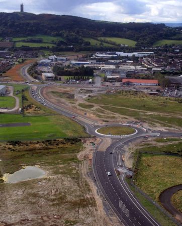
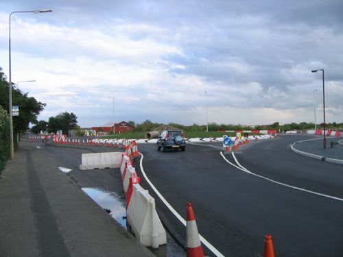
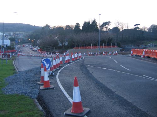
Looking
west along the scheme on 4 Oct 2009, showing the
Castlebawn Roundabout
(foreground) and the Comber Road Roundabout
(beyond). [Gareth Hutchinson]
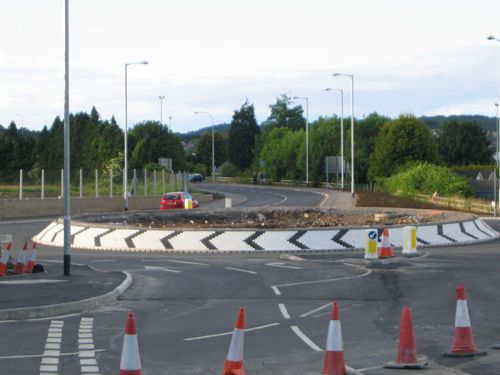
24 Sep 2009:
Work progressed well during early September with
all of the major outstanding works to pavements
etc completed by the middle of the month. The only
significant outstanding work now is on Comber
Road, but the work is now at a point where we can
say that the scheme is now largely "completed". At
project commencement the scheme was to have been
completed by early April, so this makes the
completion around 5 months behind schedule.
Pictures 1 and 2 below show the new road. Picture
2 shows the remarkable low-level street lights
that have been installed at the end of the runway
of Newtownards airport, which are even equipped
with aircraft warning lights! Picture 3 shows the
completion works underway on Comber Road. The
opening of the new road has beneffited many
people, and reduced journey times, but is still
causing quite noticeable congestion on Comber
Road, particularly leaving the town in the
evening. The constant, and fast, stream of
vehicles coming from the new link road means that
it is very hard to get onto the roundabout,
leading to traffic queueing back along South
Street and encouraging motorists to take risks
entering the roundabout.
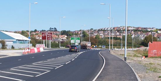
Pic 1: The completed Southern
Distributor, here seen looking east towards
Portaferry Road roundabout on 16 Sep 2009. [Wesley
Johnston]
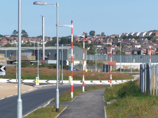
Pic 2: These special low-level
street lights at the end of the airport runway are
about half the height of normal lights. Seen on 16
Sep 2009. [Wesley Johnston]
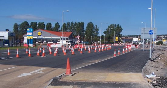
Pic 3: Work
on Comber Road still underway on 16 Sep 2009.
[Wesley Johnston]
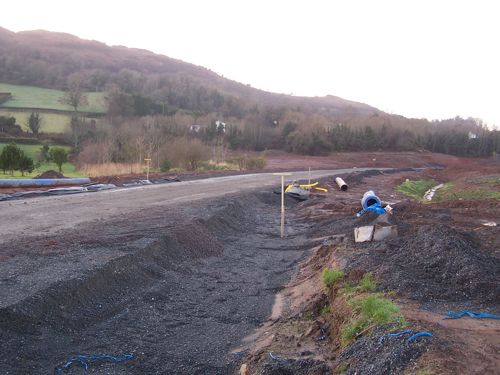
2 Sep 2009: Work has progressed
well over the past three weeks, with the western
part of the scheme now virtually completed.
However there is still a fair bit of work to be
done on the eastern part of the scheme, where the
pavements are far from complete and pedestrians
have to negotiate an obstacle course of holes,
ditches piles of materials, and cones/pipes -
wheelchair users, for example would find it
impossible to use this part of the road. Over half
of the signage is now in place. The
re-construction of Comber Road between the new
Comber Road roundabout and Circular Road is well
advanced, but the final lane layout has not been
marked out and the traffic lights at Jubilee Road
have yet to be installed. Look out for the
remarkable "low" street lights at the Castlebawn
Roundabout, which are only about 5 metres high due
to the proximity of the Newtownards Airport
runway. Some even have red warning lights on top!
It looks as if work will be substantially
completed within the next couple of weeks.
10 August 2009: Despite Roads
Service inexplicably declaring the project
"completed" at the end of July, work has continued
apace over the past two weeks on what is very
obviously an ongoing project. The footpaths on the
western stretch of the road are now completed,
although traffic is regularly held up by
construction vehicles stopping in the carriageway
to carry out electrical and other works. The
eastern stretch is less completed, with just the
foundations of the footpath on the town side now
in place. It looks as if these may be completed
within the next week or two. Work is also underway
on Comber Road to tie in the new roundabout, with
all the kerbing now in place. The final surface
has yet to go down. Workers are also digging
foundations at the end of Jubilee Road which will,
in the coming week or two, allow the temporary
roundabout here to be removed and the traffic
lights re-installed. Work to tie in the new
roundabout on Portaferry Road is still
uncompleted, and a number of direction signs have
yet to be installed. At this stage, it looks
likely that the project will be completed by the
end of August.
Since traffic was allowed onto the road ten days
ago, intitial reports have been very positive with
people reporting much faster journeys, and reduced
stress. However, some people have also reported
problems, particuarly with serious congestion
heading out of the town on Comber Road in the
evening rush hour, seemingly due to the fact that
drivers find it hard to get onto the roundabout
due to the constant stream of drivers on the new
link road. There is also some confusion on lane
markings, most notably on the Castlebawn
Roundabout where, coming from the Belfast side, it
is very unclear whether continuing to Portaferry
counts as "turning right" or going "straight on".
This is because there are four exits on the
roundabout, only two of which are open, and going
"straight on" actually involves taking the last
exit, and so could be seen as "turning right".
Some drivers have also reported confusion on the
correct use of the right-turn lane at the Scrabo
Road roundabout when coming from the Belfast
direction, which has the same issue as the
Castlebawn roundabout.
30 July 2009: Unexpectedly the
road was officially opened to traffic today, by
the Permanent Secretary of the DRD, Paul Priestly.
As of 1pm today just the western stretch (from
Scrabo Road to Comber Road) was open, although it
looks likely that the eastern stretch extending it
to Portaferry Road will open imminently too. The
new road is of a very high standard, with a 40mph
speed limit and will provide much needed relief to
travellers going to/from the Ards Peninsula as
well as traffic heading from eastern Newtownards
to Comber and Belfast. The western stretch of the
new road has been named Messines Road by Ards
Borough Council, while they have named the eastern
stretch Castlebawn Road after the proposed retail
park due to be built nearby. Mr Priestly said "The
Department has worked closely with colleagues in
NI Water to take advantage of the opportunity
presented by the construction of the new road to
considerably enhance the water and sewerage
infrastructure in the area. Although this
additional work has meant the completion of the
road has taken three months longer than
initially anticipated, there have been
significant savings to the public purse as a
result." This comment explains why the road
did not open in April as had been expected.
However, it is a bit of a stretch in my view to
claim that the road is now completed. With all
road schemes there is inevitably additional work
to be done after opening. However, in the case of
this road the outstanding work is fairly
substantial: there is still work to be done on
pavements (surfacing, tactile paving etc), while
the work to tie the new Comber Road roundabout in
to Comber Road still has a fair bit of work to do
since the reconstruction of the road still has to
be completed, and the pavements completed here.
Indeed, when driving down the road this lunch time
there were lorries parked on the "open" road
continuing to carry out work. It is my guess that
there are still a few weeks' of work yet to do
before the project can be said to be completed. Mr
Priestly also gave the cost this time as "£7
million": a completely meaningless figure as it is
just one of six different figures that have been
quoted over the past year and a half (see previous
section).
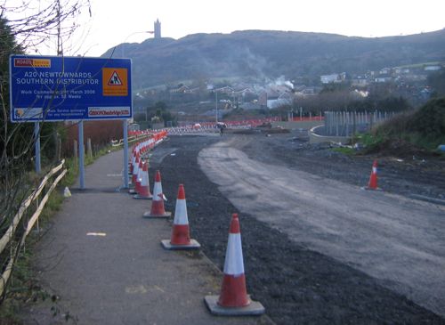
27 July 2009:
No work whatsoever has been carried out over the
past fortnight, due to the well known July
"builder's fortnight". Work resumed this morning.
The western stretch (Belfast road to Comber Road)
is almost complete, with just some pavement
surfacing and street furniture to complete. This
stretch could be finished within days. The eastern
stretch (Comber Road to Portaferry Road) is a
little further back with some road surfacing,
markings and street lighting yet to be completed.
It therefore now seems unlikely that the whole
road will be completed by the end of the month, as
predicted by the Minister at the start of June.

The almost-completed A20 marked out
and ready to go. Seen at the pedestrian crossing
leading to the Westwinds estate (on the right) on
20 July 2009. [Wesley Johnston]
The
terminus of the new road on the new roundabout on
the Portaferry Road nearing completion on 24 July
2009. The line of the old road can be seen on the
left. [Paul McIlfatrick]
12 July 2009: The Comber Road
roundabout (the central one on the scheme) finally
opened to traffic during the past week. The new
road itself is very nearly completed, with traffic
signals, street lamp heads and white lines all
added recently. Completion is scheduled to take
place by the end of the month, and this certainly
looks achievable from what we can see on the
ground. Pedestrians and cyclists are already using
the new road, as the contractors don't seem to
make any effort to prevent them, although a line
of concrete blocks placed across the road prevents
vehicles from doing so.
23 June 2009:
Site visitor Paul McIlfatrick took a series of
photos of the works six days ago, four of which I
include below. Work is currently underway to tie
the new road in to the existing Comber Road, while
works at the Scrabo Road (western) end are
completed, and works at the Portaferry Road
(eastern) end are well progressed. The Minister is
currently anticipating completion in mid summer,
which we take to be the end of July.
Pic 1: The new Scrabo Road
roundabout now open to traffic at the western end
of the scheme. Taken from the new road, which is
not yet open, on 17 June 2009. [Paul McIlfatrick]

Pic 2: The new road between Scrabo
Road and Comber Road completed except for its
final layer of surfacing. Pedestrians are already
using it. 17 June 2009. [Paul McIlfatrick]

Pic 3: The new roundabout half way
between Comber Road and Portaferry Road, which
will eventually serve the Castlebawn development.
17 June 2009. [Paul McIlfatrick]
Pic 4: The
terminus of the new road on Portaferry Road
(running beside the street lights). The designs
show this as as a signalised T-junction, but the
plans may have changed as the layout being built
looks more like a roundabout. 17 June 2009. [Paul
McIlfatrick]
7 June 2009: The Comber Road
roundabout is now almost completed, with just the
surface still to go down. Work elsewhere is
ongoing on street lighting and the footpaths.
Answering a question
in the Assembly, the Minister for Regional
Development said that the scheme would be
"substantially complete by 30 July 2009". This
represents a delay of about 3 to 4 months on top
of the expected timescale of 12 months advertised
at project inception (which was early April 2008).
This was later revised by Roads Service to "late
Spring 2009".
13 May 2009:
Work is now well underway on the new Comber Road
roundabout (see photo below) with the western end
well formed. It's not clear whether the whole road
will open at once, or just the western bit, but
either way the project appears to be over-running.
When work began in April 2008 it was timetabled to
last 12 months, which suggests we are currently a
month behind schedule. Opening seems unlilkely for
a number of weeks yet. (And we still have no idea
how much it is costing!)

The new
Comber Road roundabout taking shape on 13 May
2009. Looking south. The lamp posts indicate the
line of the existing Comber Road (traffic diverted
away). [Malcolm Johnston]
12 Apr 2009:
Progress is good on the road, withe the stretch at
the western end (Scrabo Road) now completed, and
the stretch from there to Comber Road nearing
completion. The stretch from Comber Road to
Portaferry Road is not quite so well advanced.
Work to build Comber Road roundabout itself has
only just begun in earnest in the past few days,
although preparatory work has been underway for
some months. You can get some idea of progress
from the pictures below, taken yesterday by Andrew
McCullough from Scrabo Hill (an immensely
convenient vantage point).
Pic 1: The western end of the new
road, with the completed Scrabo Road roundabout
visible (and partly open). The Ards Shopping
Centre can be seen at the top, while the new road
runs to the bottom right. Seen on 11 April 2009.
[Andrew McCullough]
Pic 2: The
central and eastern end of the scheme, with Comber
Road running left to right just above the centre.
The road can be seen snaking from the bottom left
to the Portaferry Road in the distance. A new
pelican crossing is taking shape at the bottom of
this shot. Seen on 11 April 2009. [Andrew
McCullough]
9 Mar 2009: The estimated cost
of this scheme is becoming a bit of a running
joke. As explained above, the cost of the scheme
has been given as several different figures since
February last year. When the DRD Minister was
asked for the cost in the Assembly this week, we
hoped he might be able to clarify which figure was
correct. However the figure he quoted
this time, £14m, was different again
from all previous figures! We may never know how
much this scheme is costing.
2 Mar 2009:
Lots of progress has been made over the past
month. The new roundabout at Scrabo Road is now
completed and partially open. The route from there
round to Comber Road has been kerbed and the base
surface has been put down on most of it. Street
lighting posts are also being erected along the
route. There is still no sign of the roundabout at
Comber Road, however, which to date remains a
circular gravel area with Comber Road running
intact through the middle. So far, however, it
looks as if the scheme is progressing more or less
on schedule.
Looking
west along the Southern Distributor from between
West Winds (left) and Jubilee Road (right) on 2
March 2009. Surfacing and street lighting are both
progressing. [Wesley Johnston]
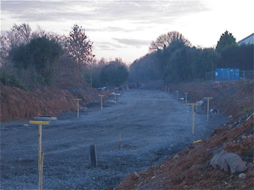
31 Jan 2009:
Two photos this time of the part of the scheme as
it passes the West Winds Estate (between Scrabo
Road and Comber Road). Most of the route now seems
to have had the gravel subsurface laid down,
although there is still a lot of work to be done,
particuarly at the roundabout on Comber Road. Back
in November Roads Service issued
a leaflet about the scheme. It doesn't say
anything new, but is a useful summary and contains
a good map of the route.

The view east towards Comber Road
from near the
West Winds Estate on 28 Jan 2009. [Wesley
Johnston]
The view
west as the road curves round towards Scrabo Road,
from
near the West Winds estate on 28 Jan 2009. [Wesley
Johnston]
14 Jan 2009: There
is continuous activity on the site with activity
seen at various locations on different days. Blair
Mayne Road South has been closed for a number of
weeks now - picture 1 shows that this is because
the road is being widened and a roundabout is
being built at its terminus on Scrabo Road -
picture 2. Picture 3 shows the road heading south
from Scrabo Road. The remainder of the road on the
south side of Newtownards is also taking shape,
although there is still a lot of mud around at
these locations. Currently the project still seems
to be on schedule for completion in "late Spring"
– which may mean May 2009.
Pic 1: Blair Mayne Road South
(south of the Shopping Centre roundabout)
seen on 4 Jan 2009. The road is closed here to be
widened. [Paul McIlfatrick]
Pic 2: The new roundabout being
built on Scrabo Road, as seen on 4 Jan 2009.
Looking out of town with Blair Mayne Road South to
the right. [Paul McIlfatrick]
Looking south along the formation
of the new road as
seen from
Scrabo Road on 4 Jan 2009. [Paul McIlfatrick]
10 Nov 2008: Work is continuing
to advance, with the road base in place along the
majority of the route. The cutting at the western
end is excavated, while works to build up the
boggy round beside the Westwinds estate is
advancing well. Work on the new roundabout where
the new road crosses Comber Road is now underway
with the foundations of the roundabout clearly
evident. Roads Service are
now anticipating that work will be
"substantially complete by late Spring 2009".
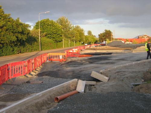
14 Sep 2008:
Work is advancing well, with the road base being
actively laid on the western part of the scheme,
to match the work already being carried out on the
eastern part. Work on the new roundabout at Comber
Road is also underway. The temporary road and
roundabout at Jubilee Road seems to be performing
quite well, with traffic apparently flowing much
better in the area than it did with the normal
traffic lights! The picture below shows the new
road seen in early September 2008.
The new
road taking shape as seen from Scrabo Hill on 8
Sep 2008. [Norman Johnston]
1 Aug 2008: The temporary road
that will carry Comber Road past the site of the
new roundabout opened at 10am on Wednesday (30th).
This temporary road features a temporary
roundabout to retain access to Jubilee Road.
However this is NOT the final roundabout which
will be about 200 metres further out of town.
Little or no work happened on the site during
July, but has started again in the past week. The
earthworks (cuttings and embankments) for the
whole road now seem largely completed with drains
also installed in places.
15 Jun 2008:
Work continues to progress well. A temporary road
is under construction that looks like it will
carry Comber Road a few dozen metres to one side
while the new roundabout is built. An excellent
overview can be found from this photo taken by
site visitor Steve Grieve (thanks!) taken in the
first half of June 2008:
The new
road works seen from Scrabo Hill in early June
2008. Comber Road runs left to right in the centre
of this picture, with the town centre off to the
left. [Steve Grieve]
18 May 2008: Topsoil
clearance is well advanced, as is the process of
clearing land vested for the scheme. Picture 1
shows the Hughes Insurance building - they are set
to lose over half of their front garden but will
benefit from having a building that will dominate
the completed roundabout. Picture 2 shows the path
of the new road heading towards Portaferry Road,
seen from Comber Road. No actual construction has
yet begun.
Pic 1: Hughes Insurance building
seen from Comber Road on 18 May 2008. They are set
to lose much of their front garden to make way for
the new roundabout here. [Wesley Johnston]
Pic 2: The
path of the new road cleared of vegetation heading
east towards Portaferry Road. Seen from Comber
Road on 18 May 2008. [Wesley Johnston]
Update on 24 Apr 2008: Topsoil
clearance work is now well underway on the route,
initially on the eastern end between Comber Road
and Portaferry Road. However more bore holes are
being drilled on the route between Comber Road and
Belfast Road and topsoil clearance has begun here
too. A press
release on the Castlebawn web site dated 2
April 2008 adds more confusion to the murky
question of how much this scheme is costing. They
claim that the scheme costs £8m, of which
Castlebawn is contributing "almost £5m".
This is at odds with both of Conor Murphy's
variant statements on the cost of the scheme.
Castlebawn claim that work will begin on the
retail park as soon as the new road opens.
Update on 2 Apr 2008: Work
officially began on the project today with an
official "sod cutting" ceremony led by Regional
Development Minister Conor Murphy. Prior
indications have been that work will begin first
at the Portaferry Road end with the work at the
Belfast end taking place later. However, the press
statement makes it clear that this work is for the
whole proposed road.
Update on 5 Feb 2008: In this
parliamentary written answer on 1 Feb, Roads
Service are saying that work will begin in
March/April 2008. The cost was given as
£20.5m of which Roads Service will
contribute £2.5m. The cost stated on this
page up until now (£3m) has obviously been
the public contribution, not the whole cost.
Update on 11 Dec 2007: No work
has yet begun, and in a parliamentary
written answer on 7 Dec Roads Service are
now saying that work is likely to begin "early
next year" and last "approximately 12 months".
Update on 27 Sep 2007: From a
helpful response to an e-mailed question, Roads
Service are now saying that the contract is likely
to be awared in November 2007, with work to
proceed in two phases, and to be completed by
"late 2008". The section from Comber Road to
Portaferry Road is due to commence first, with the
section from Comber Road to Blair Mayne Road South
to proceed later. Tenders were returned on 13
September 2007.
Update on 14 Dec 2006: Speaking
to a Roads Service employee at the Frederick
Street Link public inquiry I discovered that
planning permission has been granted for the
Comber Road - Portaferry Road section, but not yet
the Blair Mayne Road to Comber Road section. He
also said that the first of these two is being
funded privately, with the second publicly. Since
the project must proceed at one time, construction
is now timetabled for Summer 2007 and will last
approximately one year.
Update on 9 Nov 2006: I
telephoned the Roads Service today and they told
me that while the project was to have begun in
"late 2006" it has now been pushed back to "Spring
2007". They said that the scheme was currently in
the "advance design" stage.
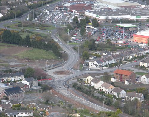
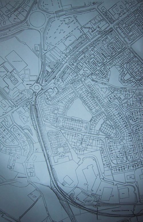
Map
This map of the western portion was given out to
the public at a Roads Service public meeting in
summer 2005. It was stressed at the meeting that
it was still a draft. The first map shows the
route from the roundabout at the Ards Shopping
Centre with the Blair Mayne Road below. Then the
new road is shown curving round to the south east.
The second map continues eastwards below Jubilee
Road to join the Comber Road.

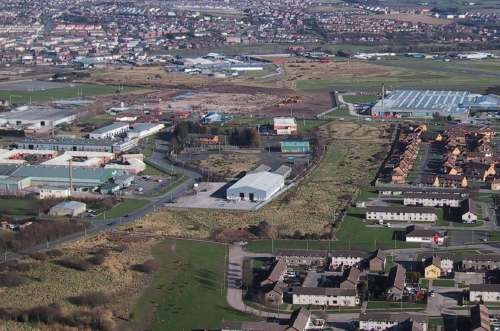
Photos
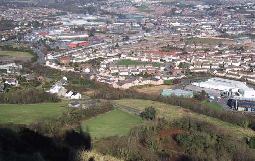
Newtownards seen from
Scrabo Hill. The new road will run from the Blair
Mayne Road South (seen on very left, grey road
going vertically). It will follow the line of
trees in front of the houses and past the test
centre on the right. [Photo by Wesley Johnston]
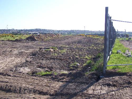
Newtownards seen from
Scrabo Hill. The new road will run through the
blank area of land between the factories of
Jubilee Road and the West Winds estate on the
right. It will join Comber Road at a new
roundabout beside where the large factory is.
[Photo by Wesley Johnston]
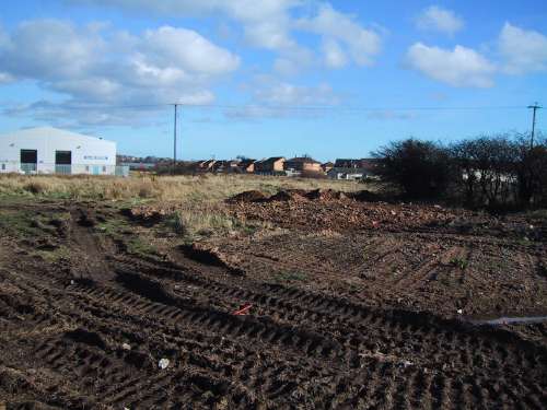
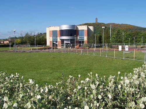
The view
of the waste ground seen in the previous photo but
from ground level. In a few years, this will be
full of vehicles travelling on the new link road.
[Photo by Wesley Johnston]
|
