|
|
Status
|
Construction scheme
(future) |
|
Where
|
To
provide a single-carriageway (2+1 lane
arrangement) bypass to the east of
Cookstown town centre. The proposals also
include the Sandholes Link Road.
Although it is being progressed as part
of this scheme, I have created a
separate page for the Sandholes
Link Road to keep this
page manageable. |
|
Total
Length
|
3.3 km / 2.05 miles of
new two-lane road
|
|
Dates
|
1978 - Scheme proposed
in East Tyrone Area Plan
1999 - Scheme
included in Cookstown Transportation
Study
2005 - Included in
Regional Strategic Transport Plan
2006 - Included in
Sub-Regional Transport Plan for
Cookstown
June 2007 -
Consultants appointed to progress design
Late 2008 - Initial
report recommends eastern corridor
10 June 2010 - Preferred route announced
7 Dec 2021 - Preferred route announced
for second time
w/c 1 April 2024 - Draft legal orders to
be published (as of Mar 2024)
16 April 2024 -
Public exhibition
22 Oct 2024 - Public
inquiry to begin
2026 - Best-case commencement of
construction, assuming funding available
(as of Aug 2023)
(construction date
changed from "2012" as of Sep 2008)
|
|
Cost
|
£70m as of Mar 2024 (changed
from 55-65m as of Aug 2023; £45-55m as
of Nov 2021; £30-34m as of Feb 2015;
£29.9m as of June 2010; £13.1m as of
Spring 2009; £10.8m in 2002 prices as
of June 2005)
of which £43m to come from the Mid
South West Growth Deal.
|
|
See
Also
|
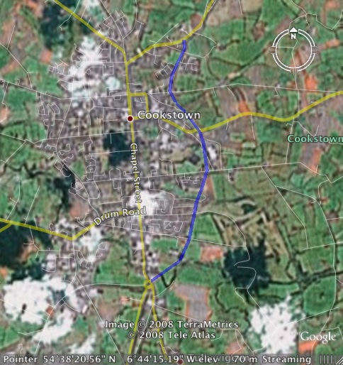
General
area map - Google Maps
Official web
site on scheme - DFI Roads
A505
Sandholes Link Road - on this site
|
Click
here to jump straight down to updates
for this scheme.
Cookstown suffers from traffic congestion
because the main A29 route through the town
centre is also the main commercial street, with
almost 16,000 vehicles per day going along the
main street as of 2024. Of this, 48% of traffic
in the town is going straight through the town,
according to the Stage 1 Scheme Assessment
Report. New developments are increasing pressure
on this route and the need for an alternative
route to service these areas is growing. This
scheme envisages a single-carriageway bypass
running round the eastern side of the town
carrying all traffic that does not wish to stop
in the town. The original proposal in 2006 was
for a more modest 'distributor' road, but it has
since expanded into a proposal for a full
bypass. It is estimated that a new bypass would
be carrying 22,000 vehicles per day if it had
been open in 2014, and 35,000 per day by 2029.
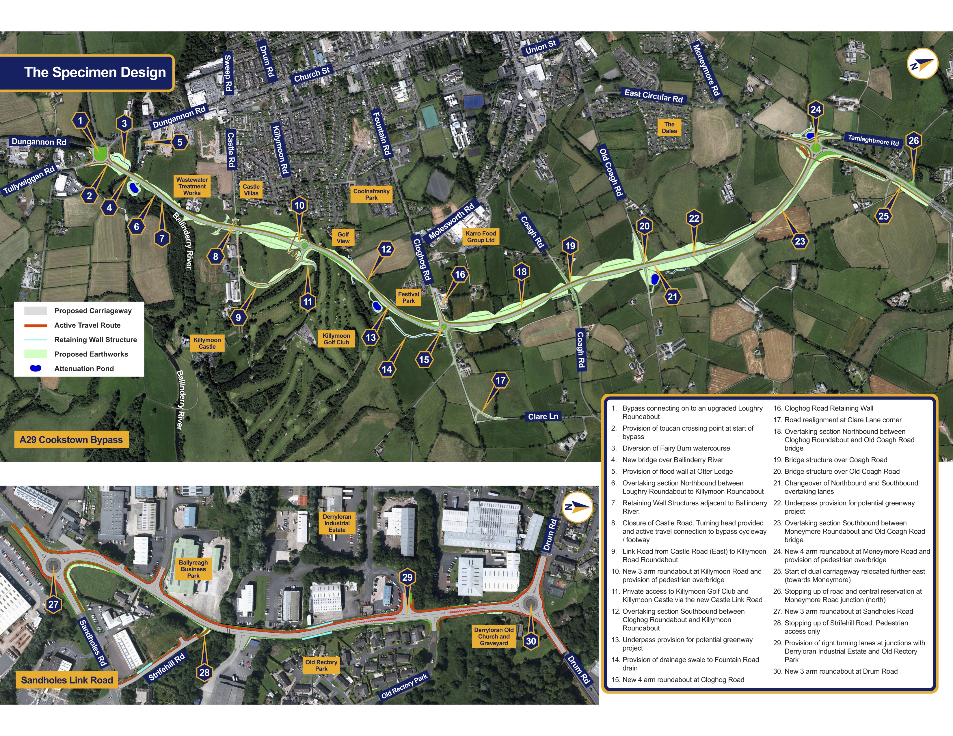
Route as proposed in 2024
The map below shows the design publicised in
April 2024 (click to view larger). At the
southern end the route begins at the existing
roundabout on the Dungannon Road. The route will
then run generally north-east across the
Ballinderry River, and then meet Killymoon Road
at a new roundabout. Castle Road will be severed
(pedestrian access to be maintained by an
underpass). The eastern end of Castle Road will
be connected to Killymoon Road roundabout by a
short link road. The plans also indicate a short
northbound overtaking lane along this stretch.
The route then meets Cloghog Road at a proposed
new roundabout just to the east of Festival
Park. After the roundabout the route runs north
over Coagh Road and Old Coagh Road on two
bridges. Finally the route meets Moneymore Road
at a new roundabout about 300 metres before the
existing dual-carriageway. The plans show the
road as having a 2+1 lane arrangement the whole
distance, with northbound traffic getting an
overtaking lane for most of the route, but
southbound traffic getting an overtaking lane at
the northern end. The whole route also features
a segregated foot/cycle way along the whole
route. The proposals also include the Sandholes
Link Road. Although part of this scheme, I
have created a separate page for it to keep this
page manageable.

Design of the A29 Cookstown Bypass as of April
2024 – click to enlarge. [ Source]
Previous Proposals
2010:
Proposals released in 2010 gave a Preferred
Route that was, from a route perspective,
identical to the 2021 proposals except that it
did not feature a junction at Killymoon Road.
Additionally, in the 2010 proposal the
out-of-town side of Castle Road would have
joined the bypass directly as a left-in/left-out
junction rather than being linked by a short new
road to Killymoon Road as in the 2021 proposals.
Finally, the 2010 proposals would have meant
closing off Old Coagh Road where it would be
severed by the bypass. However, the 2021 plans
now propose to keep the road open and bridge the
bypass over it instead.
2006: The map
here
shows the route of what was then known as the
Cookstown Eastern Distributor, as contained in
the 2006 Sub-Regional Transport Plan. Beginning
on the A29 Moneymore Road north of the town, the
route follows the existing 600 metre "East
Circular Road", constructed in the mid 2000s by
a private developer. From here the route crosses
the Coagh Road and terminates on the existing
roundabout at the junction of Dungannon Road and
Tullywiggan Road south of the town. This plan
will now not be built.
Progress
8 Oct 2025: DFI have launched a public
consultation on the scheme, this time asking the
public for their say on possible "wider social
value benefits" that the bypass could bring.
This is a fairly recent requirement of major
projects here. In their words "We must also
consider how we can create social value
benefits for local residents, businesses and
key stakeholders that may be impacted by the
construction of the A29 Cookstown Bypass. This
can take many forms including employment,
apprenticeships or skills development
opportunities for local people. It could also
provide support for health and well-being
initiatives within the local community." A
public consultation is now open in the form of a
brochure and a survey that you
can see and fill out here. The survey will
close at noon on 27 October.
25 Apr 2025: Three weeks ago DFI published
the "first day briefing" of the new DFI Minister
Liz Kimmins. This contains reference to the cold
truth – which we already knew – that this scheme
has a significant funding shortfall. The current
funding required to complete the scheme (not
counting what's already been spent in planning)
is £61m. The Mid South West Growth Deal (MSWGD)
is providing £42m of this, which leaves £19m to
be found. DFI don't currently have this kind of
spare cash. The document states that "DfI
officials have been working to explore the
funding options with MSW." It's not clear
what this means – whether it's simply an appeal
for more money, or an exploration of alternative
funding models, or some kind of loan – but it's
the obvious first step to filling the gap and
must be fully explored. If that doesn't bear
fruit, then it would be back to the Executive to
find the cash, which seems unlikely in the next
2-3 years in the face of significant
funding pressures. So although the public
inquiry has happened (the report is awaited) I
really can't see the scheme happening within
that timeframe.
28 Oct 2024: The Public Inquiry into the
Cookstown Bypass took
place last week, beginning on 22 October.
There does not appear to have been any major
opposition, with the main objections coming from
landowners affected by the road. The golf course
affected by the road withdrawing its objections
after discussions with DFI about mitigation. So
now the Inspector will write their report and
present it to DFI at a later date, probably
early in 2025. After that the question comes
down to money. The DFI Minister recently said
that the Executive has agreed to fund the £27m
shortfall left by the "pausing" of the Mid South
West Growth Deal (MSWGD) – though I can't find
that decision documented anywhere. In any case,
it may not actually come to that as we're still
at least a year away from the point where
putting the scheme out to tender will be
possible anyway and by that time the MSWGD may
well be back on the road.
29 Sep 2024: Two weeks ago
the UK government announced that the Mid South
West Growth Deal (MSWGD) was being "paused". In
my previous update below I commented that the
scheme needed total funding of £70m which had
not yet been allocated. It has since been
confirmed that £43m of this cost is due to come
from the as-yet-unratified MSWGD. So that leaves
a question mark over this scheme – and also the
Enniskillen Bypass which is too being
partly-funded by the deal and partly via the
Executive. However, the two schemes are not in
quite the same position. The A4 Enniskillen
Bypass is out to tender and construction is due
to get underway in 2025, so a delay now could
materially delay that scheme. The Cookstown
Bypass, however, has not yet had its public
inquiry nor has it gone out to tender. So even
in a base-case scenario, it would not get
underway until 2026, and this is still
contingent on the Executive finding the
remaining £27m needed. So I would not go so far
as to say this kills off the Cookstown Bypass as
it doesn't materially change anything at this
point in the process. However, if the MSWGD was
*still* paused a year from now then it might
impact the timescale/feasibility of the scheme
as that is the point that a DFI Minister would
be in a position to make a decision to proceed.
13 Sep 2024: DFI have announced that the
anticipated Public Inquiry into the Cookstown
Bypass will take place from Tuesday, 22 October
2024 in the Glenavon Hotel, Cookstown. This is
the main opportunity for members of the public
and all those with an interest in the scheme to
come along and express their views and make
submissions to the Inspector. The Inspector will
then write up a report with recommendations for
the scheme, principally whether they believe it
should happen, but also any tweaks that are
recommended to the design to deal with specific
concerns. The scheme has had a route chosen a
few times over the years, but this is the first
time we have got as far as a public inquiry. The
scheme could get underway in 2026, but that is
entirely dependent on having the £70m funding in
place at that point, which is not at all
guaranteed in the current fiscal climate.
Nevertheless, I would encourage as many as
possible to go to the inquiry.
17 Apr 2024: DFI held their public
exhibition in Cookstown yesterday (some of you
might have spotted me in the BBC article :-). A
few days earlier they published the draft legal
orders (see previous update below for what these
are) which you can see here.
They are an impressive 1 GB if you download them
all (as of course I did). You can download the
leaflet from yesterday's exhibition here.
The leaflet contains the most recent iteration
of the design, which I have reproduced above,
and is largely the same as the design published
in December 2021, which you can see by clicking
here. However, there are a
few notable changes:
- At the southern end, the existing Loughry
Roundabout on the A29 Dungannon Road is to be
enlarged to the east. In the previous design
it would have remained as it is now, with the
new bypass simply being added to it. Enlarging
it will provide a greater separation between
the arms of the roundabout, potentially
improving flow and safety.
- The location of the link to Castle Road
(serving Killymoon Castle) has been relocated
to the east of where it was previously
proposed to run. This means it will join
Castle Road in the opposite direction, heading
into town rather than directly to the Castle.
- The addition of a new underpass where the
road passes over the old railway line, to
future-proof for a planned future Greenway.
- The existing A29 Moneymore Road
dual-carriageway will now NOT be extended to
meet the new terminal roundabout. The 2021
plan had been to extend it by about 300 metres
to the new roundabout, such as happened on
Comber Bypass 20 years ago ago when the
existing A21 Newtownards Road dual-carriageway
was extended. Instead, the dual-carriageway
will merge down to one lane before reaching
the roundabout. There WILL be a left-turn jet
lane onto the new bypass, but it will diverge
from a single lane. My best guess is that this
is to improve flow at the roundabout. There
may have been concerns that people in the
right-hand lane on the dual-carriageway might
have attempted to turn left onto the bypass,
or done a 360° circle of the roundabout in
order to to "beat the queues". While perfectly
legal, this phenomenon has been observed on
the A6 at Toome and has the effect of reducing
the capacity of the roundabout and hence
increasing congestion.
- (The Sandholes Link Road, which is part of
the scheme, is unchanged from the 2021
design.)
The exhibition leaflet confirms that, if a
public inquiry is needed, it will happen in late
2024. It then goes on to suggest tendering and
construction during the period "2025-27". While
things are looking good for the scheme, it is
worth noting that it doesn't yet have a
sufficient capital allocation for construction
so this timescale will depend on cash becoming
available.
8 Mar 2024: DFI announced
yesterday that there will be a public exhibition
on the proposed Cookstown Bypass The Burnavon
Arts & Cultural Centre in Cookstown on
Tuesday 16 April. He also confirmed that the
draft legal orders (the Direction Order, draft
Vesting Order and Environmental Impact
Assessment report) will be published at the
start of April, which is one of the things that
will be on show at the exhibition. These
documents are (in order) the document giving DFI
the power to build a new trunk road, the
document giving DFI the power to buy the land
needed, and the document setting out DFI's case
for building the bypass and how they will
mitigate the impact of the scheme on the
environment. The publication comes a good bit
later than expected last summer, but we are here
at last. After the exhibition, and after having
received feedback from the public, the next step
is normally a public inquiry, which might take
place in late 2024 or 2025. The scheme does not
yet have funding – or, more precisely, the
funding expected to come from the Mid South West
Region Growth Deal is not enough to complete the
road. So it will require funding from 'another'
source if it is to be completed. The cost of the
scheme is now given as £70m, which is yet
another increase on the £55-65m figure that was
quoted in 2022, and more than double the cost
being quoted in 2015, again illustrating the
scale of construction inflation in the past few
years. So we are not yet at the point where we
can anticipate a construction date, but the
scheme is being actively progressed and the DFI
Minister does seem to be behind it.
18 Aug 2023: DFI Roads this week released
a document showing how the current roads
programme will be prioritised in the current
economic and legislative climate, where DFI is
now required to de-carbonise transport. The
Cookstown Bypass made the cut, though with
significant caveats over funding. DFI is
expected to come from the future Mid South West
Region Growth Deal. However, DFI recently
re-estimated the cost as £55-65m at 2022 prices,
a considerable increase of £10m on the previous
estimate, mostly due to construction inflation.
DFI now caution that the funding expected to
come from the Growth Deal is not sufficient to
cover the costs of the scheme. This would mean
additional funding would need to come from
either from an alteration in the allocation from
the future Growth Deal or funding from another
source for the scheme to proceed. In my previous
update I noted that DFI were expecting to
publish the draft Direction Order, draft Vesting
Order and Environmental Impact Assessment report
"in early 2023-2024". DFI have now said
this will happen in "autumn 2023", so in the
next few months. This would likely lead to a
public inquiry which would take maybe 18 months
to see through. After that, assuming there is
funding, the scheme would go out to tender, a
process which can take up to a year. This could
allow construction to begin in early 2026.
6 Oct 2022: DFI gave an update
on this scheme in their annual
report to Mid Ulster District Council last
week. They now say that they hope to publish the
draft Direction Order, draft Vesting Order and
Environmental Impact Assessment report "in
early 2023-2024". This is slippage of
several months on the timescale given just three
months ago (see previous update). I would read
this date as being summer 2023. DFI go on to
point out that proceeding will depend on the
need for a public inquiry (likely), the
successful completion of statutory procedures
(likely) and the availability of funding in
future years (unlikely in the next three years).
24 Jul 2022: DFI published their end
of year report last week. The brief
mention of the A29 Cookstown Bypass indicates
that the tiemscale has slipped again. Last
November (see below) DFI said that they hoped to
publish the Environmental Impact Assessment and
draft legal orders by mid 2022. The end of year
report says that they now plan to do this "in
late 2022-23". This refers to financial
years, so I would read this as around Feb/Mar
2023. Worth commenting again that the scheme has
yet to pass a public inquiry and there is no
funding allocation for construction, so even a
best-case scenario would not see work on the
ground until 2026.
21 Dec 2021: DFI published their latest
proposals for the Cookstown Bypass two weeks
ago. You can download the scheme
brochure here. You can also access a
computer-simulated fly-through of the scheme here.
Finally, and presumably for a limited time, you
can attend a virtual public exhibition here.
I have also posted the current design further up
this page. In the end, the route is virtually
identical to the 2010 proposals but differs in
some details, particularly the addition of a
junction (roundabout) at Killymoon Road and a
bridge over Old Coagh Road (rather than severing
it). The proposed T-junction at Castle Road has
now been deleted and replaced with a short link
road connecting Castle Road to Killymoon Road.
Other than that, the changes are mostly details
of the design and minor alignment adjustments.
It is still proposed to dual a short stretch of
the A29 Moneymore Road for consistency (similar
to what happened at the Comber Bypass 20 years
ago) and also the provision of a fully
segregated foot/cycleway along the entire
scheme. The scheme brochure anticipates the
draft legal orders (Environmental Statement,
Direction Order, Vesting Order) will be
published during 2022 which will likely lead to
a public inquiry, a process which typically
takes a year to run its course. These timescales
seem realistic and plausible. The leaflet then
says that procurement and construction could
take place in the period 2023-26. While this
timescale is certainly possible, I would not put
money on these dates as it would depend not just
on a successful public inquiry (though this is
likely) but also on the Executive giving the
scheme funding at that point (far less certain),
currently estimated to be £45-55m.
29 Nov 2021: Having languished now for
eleven years with nothing happening, some
further movement is happening on this scheme.
Firstly, DFI Published the Stage
2 Assessment Report on 10 November 2021.
It is worth pointing out that a document of the
same name was also published in 2010, but it's
likely that so much time has passed since then
that DFI have decided to update the document.
The document identifies four possible routes,
and concludes by recommending Purple A along
with the Sandholes
Link Road at a total cost of £42.8m (note
this may not include land or planning costs).
However, the document doesn't actually contain
any maps so we can't actually easily say what
this is and how it compares to the preferred
option announced in 2010! However, it does seem
to join the A29 Moneymore Road further away from
the town than the 2010 route, about 400 metres
from the start of the existing A29
dual-carriageway. All of this information is to
be presented
to the public at public events to be held
on Tuesday 7 and Wednesday 8 December in the
Burnavon Arts and Cultural Centre, Burn Road,
Cookstown from 11am to 9pm. I'd encourage all
those with an interest to turn up. Bear in mind
that, due to Covid restrictions, you must book
in – ring the Burnavon Arts and Cultural Centre
at 028 867 69949 (using Option 1). The press
release also states that DFI hope to publish the
draft legal orders by mid 2022. The
Environmental Statement has yet to be published.
There is likely to be a public inquiry once it
is, a process that can itself take up to a year.
There is currently no money allocated to
construction and DFI have not speculated on a
timescale for construction either, so there is a
bit of time to go yet.
21 Jul 2018: In their most recent report
to Mid
Ulster District Council on 29 June, DFI
Road confirmed what the council themselves said
earlier last month, namely that DFI Roads agreed
to allocate funding to resume planning for this
project. In the report DFI say they "have
appointed a consultant to assist in updating,
reviewing and taking forward scheme
development work" and go on to say that
they have "a view to publishing the draft
Statutory Orders and Environmental Impact
Assessment Report in 2020". These are the
documents that would form the basis of the
public inquiry that would certainly be needed.
If the scheme passes the public inquiry then it
moves into a list of advanced schemes that could
proceed if the (currently non-existent)
Executive gave it the funding. To explore a
best-case scenario, if the Inquiry happened in
late 2020 then the outcome would be known by mid
2021, followed a procurement process taking us
to early 2022 and work commencing in mid 2022.
But in practice there are many schemes competing
for funding so it's likely to take longer than
this. Local representatives will certainly keep
the pressure on DFI to ensure the scheme stays
as far ahead in the queue as possible.
24 Jun 2018: The scheme has now been
essentially "parked" since 2010, with only a bit
of work taking place in that time. A bit of
political pressure from Mid Ulster Council has
resulted in DFI Roads agreeing do allocate
funding to carry out more planning for this
project. It's unlikely that this further work
will lead to the project happening in the near
future. For one thing, it's not regarded as
imminent by the Investment Strategy for Northern
Ireland which just says "after 2020" (which is
just what it says against every project that
doesn't have a construction timescale). What it
probably does mean is some engineer time in DFI
Roads being allocated to reviewing the scheme
and updating it. Since it's been almost a decade
since the preferred rotue was announced, it
would probably be necessary to go back and
revisit this as road standards, traffic
movements, urban fabrics and environmental
considerations all change over time. So it's
good news that work has resumed, but I would
nevertheless not expect to hear too much more in
the next year or so.
2 May 2016: It has been over five years
since I updated this page, and the reason is
that absolutely nothing has happened on the
Cookstown Bypass since the Stage
2 Assessment Report was published in 2010.
This was confirmed in a Written
Question (AQW 54507/11-16) to the DRD
Minister in March where she said that "With
funding being allocated to other higher
priority schemes such as the A5, A6 and
Magherafelt Bypass, no further development
work is planned at this time for the Cookstown
Bypass scheme". This was unusually frank
for a DRD Minister - normally they put it in
more flowery terms like "further design work
is contingent on future budget allocations".
But in any case, it suggests that this scheme is
basically "parked" until such times as the
Executive decides that it is worth recommencing
design work, and I would therefore see it as
inconceivable that it will happen within 5
years. Given current Executive priorities I also
see it as unlikely to be completed within the
next 10 years. Needless to say, none
of this has gone down well in Cookstown.
The only change I can find since 2010 is that
the cost is now
being quoted as £30-40m, which is slightly
up on the estimate of £29.9m being quoted in
2010.
14 Jan 2011: The budget for
Roads Service in the period 2011-15 was published
yesterday. As suspected in the previous
update, budget cuts mean that this scheme looks
unlikely to proceed until at least 2015. This
also applies to the Sandholes
Link Road which is to be built as part of
this scheme.
30 Dec 2010: In the previous
update I noted how there was no update on the
timescale of construction of this scheme. The
last indication we got was in 2008 which
suggested construction would get underway in
2012. It is notable, therefore, that in this
press release two weeks ago Roads Service
merely said that "design and development
work... was continuing to progress". The
fact that there is no mention of further dates
suggests that the construction timetable is much
vaguer than previously thought. This could well
be due to the financial cutbacks.
9 July 2010: The "Preferred
Route" for the proposed Cookstown Bypass was
announced last month, on 10th June. This is the
publication of where the new road is planned to
run, although as the final design is developed,
the route may still shift a little. You can
download the public information leaflet here.
The scheme has clearly grown in the development.
The 2006 proposal was for a 2.8km long
distributor road (ie with lots of junctions)
hugging the eastern edge of the town. However,
what is now proposed is a road over 1km longer
and running much further out from the town.
While originally envisaged as a "distributor",
the plan is now for a genuine bypass with only
one intermediate junction (at Cloghog Road).
Presumably the substantially reduced traffic on
the main street, once the bypass opens, will
render a separate distributor road unnecessary.
The route is described in more detail above. The
"Eastern Distributor" proposal contained in the
Sub-Regional Transport Plan of 2006 is now
abolished, as
stated by the Minister, since it is
superseded by this more ambitious design. Two
years ago construction was scheduled for 2012,
but it is unknown if this is still the case. The
total cost of this route is given in the full
report as £29.9m.
The preferred route announcement also contained
a proposal
for an upgrade to Sandholes Road, which
links the A29 to the A505 to Omagh, to create
better links between these two routes.
8 June 2010: Roads Service
have finally decided to
tell us when the public constulation event
will take place, with less than 48 hours'
notice. It wil take place on Thursday 10th June
at South West College, Burn Road, Cookstown.
They have not felt the need to say in their
press release what time it will run
at, so presumably you just turn up on the day
and hope for the best. In any event, the
exhibition will reveal the "preferred route" for
the road. The Minister described the scheme as
consisting of "4.25 kms of new carriageway.
A new wide single carriageway will extend from
the Dungannon Road Roundabout to the south of
Cookstown over a distance of 3.95 kms to meet
the Moneymore Road to the north at a proposed
new roundabout. Under the proposal, the
existing dual carriageway between Cookstown
and Moneymore will also be extended by some
300 metres to meet this new roundabout. One
further roundabout is proposed along the
length of the bypass at its junction with the
Cloghog Road/Clare Lane, providing convenient
access to the town centre and local amenities."
I'll post up more information after the event
and once the rest of the information has been
released.
2 May 2010: Roads Service are
saying that there will be a "public information
day" during May. This is very likely to coincide
with the announcement of the preferred route,
which has been anticipated for almost a year.
This follows the presentation of the "Stage 2
Report" (a more detailed document) to the Board
of Roads Service in late March. However, no
information has been released about where or
when the public information day will take place.
16 June 2009: The Regional
Development Minister gave an update
on the scheme last week. He said that "Design
work on the proposed Cookstown bypass is
progressing well. A public consultation event
was held in January of this year and feedback
from this, together with on-going design work
will facilitate a further public information
event to announce the preferred route
alignment later this financial year."
This may mean that the preferred route
announcement may not be announced until Spring
2010, a little later than was hoped last year.
16 May 2009: A few months ago,
the detailed initial "Scheme Assessment Report"
was issued and is
available on the Roads Service web site.
Although the web site is giving the cost as
"£13.1m", the document itself gives the cost of
the scheme as being massively higher - in the
range £27.4m to £43.9m depending on the route
chosen. The document recommends that the eastern
route is the best route, although it also
recommends an additional road (called the
Sandholes Link Road) to link the new road to the
A505 Drum Road to the west of the town. The
eastern route will now be developed further and
route options developed. Last October it was
said that the preferred route would be announced
"later in 2009".
21 Oct 2008: According to an
Assembly
written answer on 17 October, the
preferred route corridor (the general route of
the road) is due to be announced "later this
financial year", which we can take to mean
sometime around Spring 2009. The specific
preferred route (the exact route within the
corridor) is scheduled to be announced "later in
2009".
16 Sep 2008: Mid-Ulster MLA
Billy Armstrong has
claimed that he has had correspondence
from Roads Service to the effect that this
scheme will go ahead in 2012 with completion in
2014. This is in contradiction to previous
official information with has been that this
scheme is in the "forward planning schedule",
which generally applies to scheme that are at
least five years away from commencement.
Nevertheless, if this information is accurate,
then it means that the scheme may have been
moved to the "preparation pool" for schemes that
are within five years of commencment. However it
is also important to remember that the
anticipated start dates for the majority of new
road schemes tended to get later over time, so
this date of 2012 may well prove to be on the
optimistic side. It is still unknown what
contribution, if any, private developers will
make.
7 Mar 2008:
As of now, only the short 600 metre section of
the road at its northern end has been completed.
Consultants were appointed in June 2007 to
progress a design, but according to this
written answer, such roads can typically
take "at least six years to progress". This
should not be taken as a definite timescale, but
rather a general indication that construction is
not imminent. Private developers may, of course,
progress parts of the scheme earlier than this.
|
