|
|
Status
|
Construction scheme
(future) |
|
Where
|
To
upgrade the Sandholes Link Road,
Cookstown, to provide a better link
between A505 Drum Road and the Loughry
Roundabout on the A29. |
|
Total
Length
|
0.6 km / 0.4 miles
|
|
Dates
|
2010 - Proposed during
planning for A29 Cookstown Bypass
10 June 2010 -
Preferred route announced
7 Dec 2021 - Updated preferred route
announced
Being taken forward as part of the A29
Cookstown Bypass scheme - as of 2024
2025-27 - Possible procurement and
construction - as of Jun 2024
|
|
Cost
|
Being costed as
part of the Cookstown Bypass, no
separate figure available as of 2024
£3.3m as of June 2010 |
|
See
Also
|
General
area map - Google Maps
A29
Cookstown Bypass - on this site
Official web
site on A29 Cookstown Bypass - DFI
|
Click here
to jump straight down to updates for this
scheme.
In June 2010, and again in December 2021, the
preferred route was announced for the proposed
A29 Cookstown Bypass. The bypass will run to the
east of the town connecting the Loughry
Roundabout (on the A29 Dungannon Road at the
south of the town) to the Moneymore Road to the
north. The problem with this is that the A505
Drum Road (which goes west towards Omagh) will
continue to join the main street in Cookstown
since it's on the 'wrong' side of the town to
the Bypass. Motorists coming from the west on
the A505 and wishing to continue north towards
Moneymore would likely continue to use the main
street.
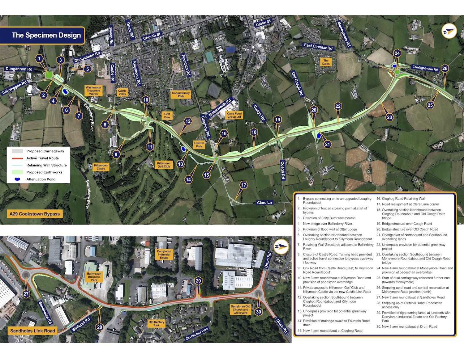
This proposal would upgrade the local road
network to make it much easier to access the
proposed Cookstown Bypass from the A505 and
encourage as much through traffic as possible to
divert onto it. The plan, as shown on the map
below, would upgrade a local
industrial/residential road - the Sandholes Link
Road - and provide roundabouts at either end.
The upgraded road would have one lane in each
direction with right-turn pockets for every side
road. This would encourage vehicles to transfer
across to the Bypass rather than continuing to
the main street. A more detailed map of the
proposed upgrade to Sandholes Link is shown in
the bottom of the image of the A29 Cookstown
Bypass below (click to enlarge) - note that
north is to the right in this view with
the A505 Drum Road to the right.
It is likely that the A505 number will be
reassigned to the upgraded Sandholes Link Road,
but this is conjecture on my part as DFI have
not said anything on this matter.
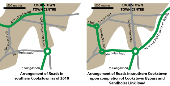
Earlier proposals
The map below shows the route as proposed in
2010. It was the same as the 2021 proposal,
except that at the southern end of Sandholes
Link it cut across an existing minor road
(Strifehill Road) to meet Sandholes Road. This
short-cut has now been deleted, so the current
proposal is to follow Sandholes Link the whole
way to Sandholes Road.
Updates
19 Jun 2024:
DFI have now published
the most recent design for the Cookstown Bypass
and Sandholes Link Road. The design is shown
further up this page (the lower panel labelled
"Specimen Design") which has north to the right.
It is virtually unchanged, except that the
alignment of the approach to the new roundabout
on Sandholes Road is not quite as torturous as
previously. The Sandholes Link,
although not physically part of the Cookstown
Bypass proposal, is being taken through
planning along with it. The just-published
exhibition leaflet confirms that, if a public
inquiry is needed, it will happen in late
2024. It then goes on to suggest tendering and
construction during the period "2025-27".
While things are looking good for the overall
scheme, it is worth noting that it doesn't yet
have a sufficient capital allocation for
construction so this timescale will depend on
cash becoming available.
21 Dec 2021:
DFI published their updated 'preferred route'
for this scheme on 7 Dec 2021. You can see it
above. Although it remains a single-carriageway,
the route has changed since the 2010 proposals -
it is now an upgrade of the Sandholes Link Road
for the whole distance from Drum Road to
Sandholes Road, rather than subsuming Strifehill
Road as was proposed in 2010. This makes the
layout of the southern of the two roundabouts
slightly more tortured, but DFI have come up
with a design that works despite this.
.
|