|
|
Status
|
Construction scheme
(proposed) |
|
Where
|
To
construct a new grade-separated junction
on the A2 Sydenham Bypass to improve
access to Titanic Quarter via Connsbank
Road. |
|
Total
Length
|
n/a |
|
Dates
|
2005 - Proposed in
Belfast Metropolitan Transport Plan
Planning application
submitted - Oct 2009
Planning permission refused on a
technicality - Apr 2012
DRD confirm that scheme is still a
condition of planning Titanic Quarter -
Mar 2015
DFI considering a plan to reduce scope
of scheme to a signalised T-junction -
Apr 2025
|
|
Cost
|
Unknown - see
"funding" below |
|
See
Also
|
General
area map - Google Maps
Existing
A2 Sydenham Bypass - on this site
A2
Sydenham Bypass widening - on this
site
Connsbank
Link Road - on this site
|
Click
here to jump straight down to updates.
The Belfast Metropolitan Transport Plan 2025
(BMTP), published in 2005, recognises that the
development of the Titanic Quarter area of the
docks will require a second access point.
Currently, the access point at Queen's Quay / M3
offslip is the main entry point. In addition,
the existing traffic-light controlled junction
on the Sydenham Bypass at Dee Street creates a
bottleneck for traffic travelling east from the
M3 motorway.
This privately-funded plan would see the Dee
Street junction closed, and replaced by a new
junction at the Connswater River bridge about
700 metres further east. The Connsbank Road
(currently closed to traffic) would be re-opened
to connect the junction north to Airport Road.
All vehicular access to and from Victoria Park
will be via this new road, although the existing
"car and pedestrian" subway will be retained.
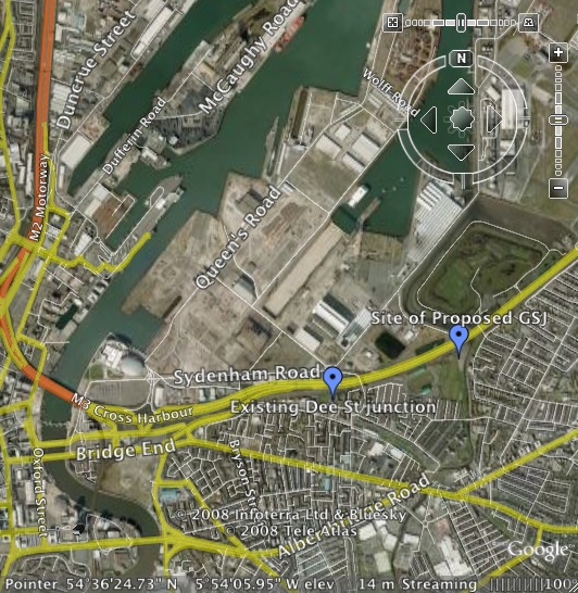
The location of the
new junction, and the existing Dee Street
junction, are indicated on this screenshot from
Google Earth (Titanic Quarter is the huge area
around Queen's Road). The thin white link
heading north west from the site of the proposed
GSJ is Connsbank Road which would be re-opened
as part of the scheme.
In February 2010, a preliminary design of the
proposed junction was released to the public, as
part of the wider A2 Sydenham Bypass widening
scheme. This design is shown below. It shows
that this will be a "compact" grade-separated
junction characterised by looped sliproads
connected with roundabouts, and relatively short
merges with the Sydenham Bypass. The planning
application (ref: Z/2009/1266)
was submitted in October 2009, and Roads Service
have stated that the scheme is likely to proceed
before the Sydenham Bypass widening scheme
proceeds.
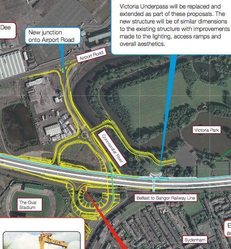
Design of
the junction as of February 2010. [Roads Service
map
Updates
20 May 2026: Belfast Harbour have just
published their new masterplan
for the next 25 years, and lo and behold my
fears of a year ago (see below) are realised.
The Harbour do indeed seem to be proposing to
scrap the plan for a grade-separated junction on
the A2 Sydenham Bypass and replace it with an
at-grade traffic light junction. This is not
mentioned in the masterplan, and I am only aware
of it because it's visible if you zoom in on
their overall
map. A plain reading of their map (below)
shows another signalised junction located a few
hundred metres east of the Dee Street junction,
with a new link road into Titanic Quarter. As I
said in April 2025, given that an at-grade
junction would be significantly cheaper for the
developer to construct I can see why this would
be a good outcome for them. However, the real
and only question is whether this would be a
good outcome for the traveling public. I
don't see how adding another signalised junction
to the A2 could be a good plan. My understanding
is that the provision of the Connsbank junction
remains a condition of planning for TQ, and if
DFI have accepted this alternative design then
they would need to have a pretty waterproof case
to explain such a major decision to the public.
If they have not accepted this design, then the
one shown in this masterplan doesn't make sense
at all. If DFI are minded to scrap the
grade-separated Connsbank junction, then at the
very least they would need to close the
signalsied junction at Dee Street so we don't
end up with two congested junctions in quick
succession at the end of the M3. Traffic coming
from Dee Street traffic would instead cross the
bridge and continue along Airport Road and
access the new junction from there. DFI please,
if you're not going to make it better, at least
don't make it worse!

Closeup of part of this
map from Belfast Harbour, showing the
proposed new signalised junction marked with a
red arrow, and the nearby existing Dee Street
junction marked with a green arrow. May 2026.
The site of the proposed grade-separated
Connsbank junction was further to the right, at
the bottom of the orange area.
25 Apr 2025: Well it has been over TEN
YEARS since I last had anything to share about
this scheme, but here we are. It remains a
condition of planning for the development of
Titanic Quarter, but has not yet been built.
Three weeks ago DFI published
the "first day briefing" of the new DFI Minister
Liz Kimmins. In this document DFI say "Since
early 2021, Departmental officials have been
working with Belfast Harbour and their agents
to develop a new Strategic Transport Master
Plan for the area. While progress has been
made on the scoping for a Transport
Assessment, we have not reached agreement on
major transport infrastructure provision and
proposed green travel measures." Since
it's a condition of an existing planning
application, it's not clear to me why the
provision of the junction requires agreement at
all. But that's what it says. It then goes on to
say "The developer’s agents have proposed an
at-grade junction to gain access to the
Sydenham bypass, as an alternative to the
grade separated junction discussed above. The
developer’s rationale for the alternative
proposal is based on emerging and significant
change to planning and transport policy which
has a greater emphasis on more sustainable
transport proposals reflecting climate change
obligations. Work to assess the alternative
at-grade proposal is well advanced and is
anticipated to be complete soon." Given
that an at-grade junction would be significantly
cheaper for the developer to construct I can see
why this would be a good outcome for them.
However, the real question – indeed the ONLY
question – is whether this would be a good
outcome for the traveling public. Given the
problems generated by Dee Street lights, I
struggle to see how adding another set
of traffic lights to the Sydenham Bypass would
be a good outcome for anyone, so I do hope that
DFI have enough foresight to resist watering
down this longstanding plan. Once Connsbank Link
is built there is even the possibility of partly
or even fully closing Dee Street junction. We do
not want a repeat of the Larne
West fiasco which has seen planned
infrastructure uncompleted due to planning
failures.
11 Mar 2015: Some clarity has emerged
thanks to a Question
for Written Answer in the Assembly in
early February. When directly asked about this
scheme, the DRD Minister confirmed that "the
provision of the Connsbank junction is a
planning condition of the overall Titanic
Quarter Phase 2 development lands" and
clarified that "The trigger for the provision
of the junction is based on the opening of the
Titanic Belfast (Visitor Centre) and one-fifth
of other Phase 2 development as defined in
vehicular trips within an approved Transport
Master Plan". This latter point clarifies
the position I alluded to in the previous
update. However, the Minister went on to explain
that "given the economic downturn, Titanic
Belfast is the only development currently
implemented within these lands and a
time-frame for the construction of the new
Connsbank junction is therefore uncertain".
So the translation is this - the junction has to
be provided once Titanic Quarter reaches a
certain level of development, but the economic
downturn means the required level of development
is not going to happen for quite some time yet,
thus the junction is not going to be built in
the foreseeable future.
27 Apr 2014: In the previous update
about two years ago (see below) I noted that
Titanic Quarter Limited were attempting to
change the trigger point for provision of this
junction so that it did NOT need to provided
before the Titanic Visitor Centre opened, as had
originally been the case. They made a case based
around things like the fact that visitors to the
Centre were unlikely to be arriving or departing
all at once, and were unlikely to be traveling
during the rush hour. This case seems to have
been convincing since the Planning Service granted
permission for their request back in March 2012.
The permission has not removed the requirement
for this junction, merely how developed Titanic
Quarter has to be before its provision is
"triggered". I must confess to being stumped by
the wording of the document (see
summary version here) so I can't speculate
as to when this might be. Suffice to say,
nothing has happened in the past two years and I
have not seen any new planning applications for
construction of the junction being submitted
since the previous one was refused on a
technicality in April 2012.
21 July 2012: According to the minutes
of a Roads Service Board meeting back in March
(but just
published) Roads Service are content with
Titanic Quarter Limited's attempt to change the
trigger point for provision of this junction
(see previous update). It is not clear whether
the Planning Service has made a formal decision
yet. However, the fact that no work is taking
place despite the recent completion of the
Titanic Signature Project implies that either
way a delay will be the outcome. Of more
significance is the fact that the planning
application to build the junction, submitted
nearly three years ago, was refused in
April 2012. The DOE wrote to the applicant on
24th April stating that permission was being
refused on the grounds of a procedural
technicality. The letter (see here
under 'Associated Documents') says: "On 10
June 2010 the Department requested Further
Environmental Information ... the information
must be submitted within three months from the
date of the request or such extended period as
may be agreed in writing between the applicant
and the Department. ... No information or
further request for an extension of time has
been received by the Department. Your
application is therefore deemed refused."
Although it's not clear why it took two years to
lead to a refusal when the deadline was only 3
months, this may well suit the revised timescale
suggested by the attempt to change the trigger
point. The bottom line is that we should not
hold our breath for seeing work begin any time
soon.
8 Oct 2011:
The minutes
of a meeting held almost exactly a year
ago (which I have just found) sheds some light
on this scheme. It says "Colin Sykes (CS)
reported the provision of Connsbank junction
is a planning condition of the overall Phase 2
development however an Article 28 application
to remove the opening of the TSP as a trigger
for the junction was received in May 2010.
Roads Service has provided a response and has
requested that further information be provided
in order to assess the transport issues
involved." This appears to mean that
Titanic Quarter Limited had originally agreed to
build this junction as soon as the Titanic
Signature Project (TSP) was completed. The TSP
is currently nearing completion. The "Article 28
application" appears to be an attempt by Titanic
Quarter Limited to remove this requirement.
Although Roads Service say that they have
replied, their actual response is not recorded
so we don't know if they agree or disagree.
Presumably the TSP-based trigger was set up in
order to provide better access once traffic
levels reached a certain point - and it could be
that traffic levels in Titanic Quarter are not
expected to be as high as anticipated when the
trigger was agreed. The minutes of a DRD
board meeting held on 8 August 2011 are
very vague, but suggest that the issue around
the timing of this junction is still ongoing.
There is no sign of any work on the ground.
1 March 2010: As part of wider
documentation, published
in late Feb 2010, detailing the preferred option
for upgrading the Sydenham Bypass new
information on this scheme has been released.
This includes the design of the document (shown
above) as well as the information that the
planning application for the junction was
submitted in October 2009 and is currently being
considered. Roads Service have indicated that
the scheme is likely to proceed before the
upgrade of the Sydenham Bypass. The latter
scheme is due sometime between 2014 and 2018, so
this scheme may well proceed in the next few
years. The fact that it is being funded by the
developers of Titanic Quarter, means that there
may be a more immediate motivation to have it
built.
25 Apr 2008: Roads Service
kindly responded to my request for an update on
the scheme. They confirmed that the scheme is
being privately funded and that the timescale
therefore depends on developments in Titanic
Quarter. However, they are apparently also
working to try to ensure that the scheme
proceeds at the same time as the Sydenham Bypass
widening scheme (see link above) to minimise
disruption. The widening scheme is due to take
place sometime in the period 2013-2018 which may
help date this proposal as well.
Funding
This scheme is to be privately funded. The
Belfast Metropolitan Transport Plan states that
"The timing and the provision of all access
improvements to the Harbour Estate (Titanic
Quarter), as well as other improvements to
infrastructure, public transport and transport
initiatives, as part of the phased development
of the area, will be clearly identified and
agreed with the Department. The funding for
all these improvements will be the
responsibility of developers either in full or
in a very substantial part.". This was
confirmed by Roads Service by e-mail in April
2008.
Photos
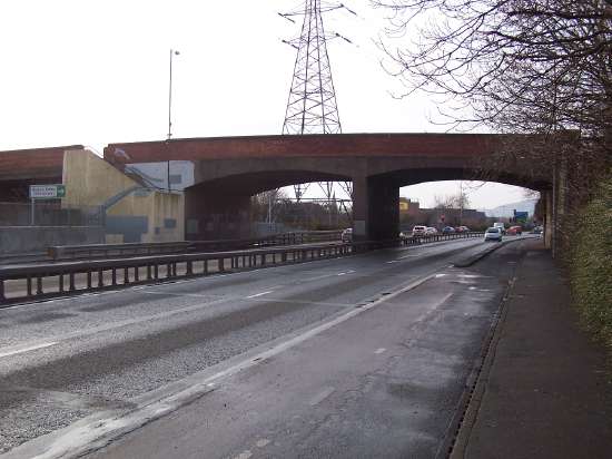
The Dee
Street bridge over the A2 Sydenham Bypass seen
looking west in late 2006. The road goes over
the bridge to the right, then curves round 180°
to join the A2 at traffic lights just beyond the
bridge. This junction will be closed as part of
the scheme. [Photo by Wesley Johnston]
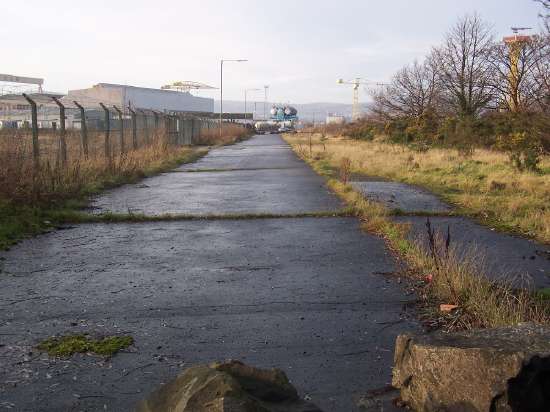
Site of the new junction. This view
looking north west along the disused Connsbank
Road is taken from the Sydenham Bypass (which
runs left to right behind the camera). This road
would be re-opened to provide access from the
new junction to the Titanic Quarter ahead.
Picture taken in late 2006. The Connswater River
runs to the right of the road. [Photo by Wesley
Johnston]
|
