|
|||||||||||||||||||
|
|
|
||||||||||||||||||
|
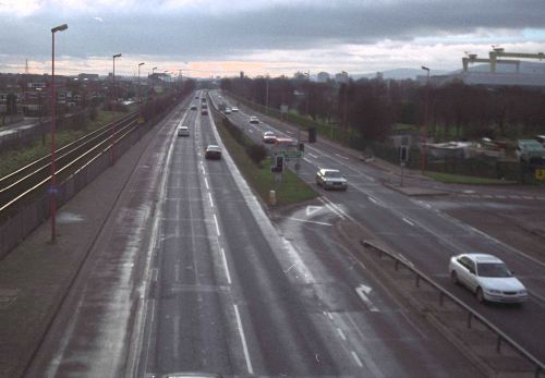
View looking south west (towards the city centre) along the Sydenham Bypass from the former entrance to the City Airport in 2000. Since this was taken the crash barriers on the left (beside the railway) and in the centre have been upgraded. [Wesley Johnston]
18 Aug 2023: Well, it's now
been seven years since the last update, as pretty much
nothing has happened on this scheme now since 2010. DFI
Roads this week released
a document showing how the current roads programme will
be prioritised in the current economic and legislative
climate, where DFI is now required to de-carbonise
transport. Unsurprisingly, the document states that work
on the Sydenham Bypass is now "paused", an
acknowledgement of what was already the case. So the
next thing is to await the publication of the new
Belfast transport plan (Eastern Transport Plan) expected
sometime in the next couple of years. That is the plan
that will decide whether the widening plan for the A2
remains a live plan or whether it will be abandoned. A
lot has changed in terms of public opinion since the
scheme was last publicised in the first decade of this
century, so it's a fairly open question as to what will
happen next. 14 Sep 2016: I was surprised to
note that it has been almost six years since I had
anything to report about this scheme, and this is
basically because nothing has happened (unless you count
the new
parapet that was built on Dee Street bridge in
2013, which you probably shouldn't). The TransportNI web
site now contains the brutally honest statement: "Due
to current budget restrictions there is insufficient
funding to allow development work to continue.
Progression of the scheme is subject to future budget
statements". So in other words this scheme is on
hold, nothing is happening, and nothing is likely to
happen for the foreseeable future. See you in another
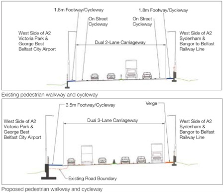
six years perhaps? 19 Oct 2010: Roads Service's web site is saying that the next stage of the design (what they call the "Stage 3 Process") will be completed in the summer of 2012, "subject to finance". If "Stage 3" refers to one of the six "gateways" that Roads Service follows for each scheme, then this would progress the design to the point where it could be put out to tender. It is extremely unlikely that funding will be available in 2012 to construct the scheme, which according to latest Roads Service information is still estimated to lie somewhere in the period 2014-18. 27 Mar 2010: Roads Service held their consultations at the end of February. They issued their leaflet on the preferred option, available here. The Stage 2 report, available on the Roads Service web site, shows that they also costed other options, including constructing the eastbound carriageway around the NORTH of Victoria Park, and one where eastbound traffic went on a circuitous route around the City Airport. Neither of these options was cost effective. The chosen option will see all the widening on the north side of the existing road. Dee Street bridge will be rebuilt, but the road realigned away from the Sydenham Road roundabout - apparently requiring the demolition of the road salt depot. The existing signalised junction at the entrance to the City Airport will, apparently remain. The leaflet also shows the proposed new grade separated junction at Connswater - this, however, is being taken forward independently, ahead of the widening, by a private developer. I have also received reassurances from Roads Service that the original 1959 opening plaque (currenty sited near the footbridge) will be preserved and reincorporated in some way into the upgraded road. Note that the Stage 2 report increased the cost estimate of the scheme from £29m to £44m. 22 Feb 2010: Roads Service are holding two more "public information events" this week and next. This will likely include an announcement of the "preferred option", ie some concrete proposals for exactly what is to happen to the Sydenham Bypass, and the junctions along it such as at Dee Street and the proposed new junction at Connsbank Road. The events will be held as follows:
As always, I would strongly encourage all those with an interest in the scheme to turn up as this is one of the main opportunities the public has to engage with the planners. 23 Jan 2010: According to their web site, Roads Service "approved the Stage 2 report" into this scheme on 21st December, although they offer no further explanation as to what this means or what the report contains. It could refer to the "design options" that were still being planned late last year following the public consultation in May. If so, then this report would contain a range of different options for increasing the capacity of the Sydenham Bypass and improving the junctions along it. This would likely result in a second public consultation and eventually a "preferred option". It will hopefully be published in due course. 2 Nov 2009: Over the past year work has gone on the background. In their report to Belfast City Council last week, Roads Service made a statement of progress. It doesn't give any details, but at least confirms that work is ongoing: "Preliminary work is continuing on a strategic road proposal to widen a 2.5km stretch of the A2 Sydenham Bypass. ... Following completion of the initial assessment and consultation processes, the scheme design is being taken forward through consideration of a number of design options. Roads Service is working closely with DOE Planning Service on the provision of a new junction to serve the Titanic Quarter." (The new junction referred to is discussed here.) Note that the Sydenham Bypass will be fifty years old on 23rd November. This is significant because it was the first modern dual-carriageway to be built in Northern Ireland. 24 Nov 2008: Roads Service released a leaflet about the scheme in November 2008. It does not contain anything new, but is a useful summary of the current position on the scheme. The leaflet estimates construction between 2014 and 2018. 16 May 2008: The public consultation was held over the past couple of days. Much of the description above as well as the maps are based on information gleaned at the inquiry. A PDF copy of the leaflet distributed at the event can be download from the Roads Service web site here. 24 Apr 2008: Roads Service kindly responded to my request for information on this scheme. The scheme is currently scheduled for construction between 2013 and 2018 (subject to permission and finance). Roads Service is trying hard to ensure that the scheme proceeds at the same time as the new grade separated junction at the Connswater bridge (see link above) to minimise disruption. The grade separated junction is being progressed by the private sector through a different planning process, so this is not a straightforward task. They also confirmed that there is currently NO plan to extend motorway restrictions from the current M3 further along the Sydenham Bypass, apparently due to the need to provide provision for cyclists and pedestrians. This seems a relatively weak reason, however, since a segregated cycle and footway would not only be safer, but would not prevent motorway restrictions from being applied to the road itself. An initial public consultation is due to take place in May 2008. |
|||||||||||||||||||