|
|
Status
|
Construction
scheme (future) |
|
Where
|
To
connect the A4 on each side of
Enniskillen by building a bypass to 2+1
standard to the south of the town. |
|
Total
Length
|
2.0 km / 1.3 miles
|
|
Dates
|
Jul 2006 - Proposed in
"Expanding the SRI Programme" document
Apr 2008 - Scheme
given go-ahead to enter planning
27 Jul 2011 -
Preferred route corridor announced
9 June 2014 - Scheme granted Gateway 0
approval (ie, it passes its strategic
assessment)
17 June 2015 - Public
exhibition of referred route (the "Stage
2 Assessment")
12 Apr 2018 - Public consultation held
Jan 2022 - Advanced
site works began
20 Feb 2024 - Scheme
given funding by Executive
30 April 2024 - Scheme went out to
tender
Late summer 2025 - Construction was to
begin (as of Jun 2025)
BUT is on hold as of Jan 2026
|
|
Cost
|
£35m as of Dec 2023
(changed from £25-30m as of Aug 2023;
changed from £30-35m as of June 2018;
£19.2m-£31.9m for inner route as
of July 2011; changed
from £18m as of 2006.)
Partly funded (£12.5m) from Mid South
West Region Growth Deal
|
|
See
Also
|
Official web
site on scheme - DFI Roads
General area
map - Google Maps
|
Click here to jump
straight down to updates for this scheme.
Enniskillen remains a
bottleneck for long distance traffic on the
Belfast <> Sligo route because all traffic
must use the A4 Enniskillen Throughpass which
was opened in 1986. While a big improvement over
going through the town centre, this still
involves going close to the heart of the busy
town where strategic traffic has to mingle with
local traffic and this delays both groups of
users.
This scheme would see the main A4 route
diverted to the south of the town. The road, as
currently proposed, would be built to 2+1
standard (ie one lane each way plus an
alternating overtaking lane) and extend from the
A4 Dublin Road at the eastern side of the town,
terminating on the A509 Derrylin Road at the
western side of the town (which will likely
become the A4 for a short distance). The road
will have to cross the Erne, and the bridge will
be a significant structure. A smaller bridge
will be needed to cross the Sillees river. DFI
estimates that it will take 40% of the traffic
on the A4 out of Enniskillen town centre.
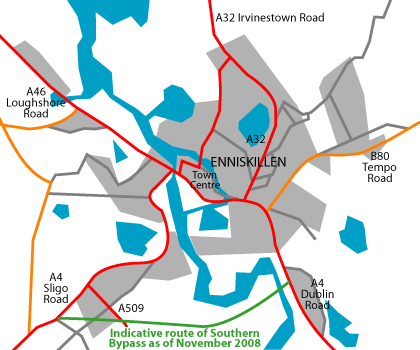
Route
The map below showing
the approximate route. It would seem likely that
the existing road through the town centre would
lose the "A4" label, and that this number would
be reassigned to the Southern Bypass.
Updates
6 May 2026: As we know, the Mid South
West Region Growth Deal is part-funding this
scheme to the tune of £12.5m. This
question for Written Answer in the
Assembly, which was answered in March, suggests
that the department no longer has all the funds
needed to proceed with the scheme due it being
surrendered back to the Department from Finance.
This is presumably because it was not spent in
the financial year due to the Minister pausing
the project to await the outcome of her A5 legal
challenge appeal. I have still not heard a good
reason why this particular scheme has to be
paused, given that it was approved seven years
ago which by my understanding means it is not
vulnerable to legal challenge. Anyway, the DFI
Minister Liz Kimmins responded to the question
by saying that the funding for this scheme will
be 'ringfenced' in the future because it is a
scheme that the Executive has collectively
committed to building. This means that the loss
of funding is more of a matter of financial
procedure than a genuine threat to the scheme.
We await the outcome of the appeal.
11 Feb 2026: Following on from the last
update two weeks ago, the DFI Minister Liz
Kimmins has
confirmed that the project is indeed
on hold pending the Court of Appeal's ruling
into the ruling on the A5 project. My
understanding is that this project is not
vulnerable to a legal challenge since the
decision to proceed was taken too long ago, so
I'm not sure why it needs to be paused, but that
seems to be the position nevertheless. The
Minister did say that "I have ensured these
schemes can remain live until the final
judgment is delivered through the extension of
the tender validity periods for ... the A4
Enniskillen Bypass." So unfortunately
nothing more is going to happen on this project
for a while yet. It's worth noting that it's now
four years since the preliminary site works,
including vegetation clearance, took place, so
if it goes on much longer some of this work may
need repeated.
27 Jan 2026: The DFI Minister, Liz
Kimmins confirmed
in the Assembly on 19 January that she has
paused delivery of the A1 junctions
phase 2 scheme due to the A5 court ruling.
She added “We have to await the Court of
Appeal's ruling, because it is important that
we consider it fully when looking at the next
steps for all major roads projects, because we
do not want to be in a scenario where we face
challenges on everything.” DFI’s appeal
was heard in December, but we do not know when
the result will be given, or what it will be. It
is my understanding that this scheme would not
be vulnerable to a legal challenge as the
decision to proceed was taken too long ago, but
it looks as if DFI are hanging tight on this
scheme until the result of the appeal is known,
presumably because the future of the entire road
building programme is in jeopardy if they lose
the appeal. Bottom line is that we won’t see any
work taking place on the Enniskillen Bypass
until at least the appeal ruling is given.
8 Oct 2025: Well, it now seems that this
project is slipping. In June I said cheerfully
that work should get underway before September.
And it hasn't, of course, and I was wondering
why. Three weeks ago DFI Minister Liz Kimmins
was asked
this very question and she replied in a very
general way: "I am very mindful at present of
the impact of the judgement in the A5WTC
project which was extremely disappointing and
where I have lodged an appeal. It would not be
appropriate for me to comment in detail on the
judgement while the appeal is live but, as my
officials work hard to prepare for the appeal
hearing, I will also take the necessary time
to carefully consider the potential impact of
the judgement on other projects as they move
through the next stages of their delivery,
which will include the A4 Enniskillen Bypass."
My understanding is that the Enniskillen Bypass
isn't susceptible to a legal challenge under the
Climate Change Act as the decision to proceed
was taken more than six weeks ago. I could be
wrong in that – legal experts can correct me if
so - but whatever the reason, it seems that DFI
are now reluctant to appoint the contractor just
now. Given that the A5 appeal is likely to take
a year to go through the system, you could
potentially be looking at a delay of that
length, or longer. But the lack of detail from
the Minister means it's impossible to really
say. But bad news for Enniskillen in the
meantime.
30 Jun 2025: The start date for this
project is approaching, though it has slipped
again. In a Written Answer in the Assembly
published last week (AQW 28729/22-27) the DFI
Minister said that "procurement ... is at an
advanced stage, with tender assessments well
underway. Following completion of this, it is
hoped that a contractor will be appointed to
begin construction in late Summer
2025." There months ago the
Minister said "early Summer", so presumably the
tender assessment process has taken longer than
anticipated. Nevertheless, this means we are
likely to see work get underway on site before
September. This might push completion into early
2027 as it's estimated to take about 18 months
to complete. In relation to the risk to this
scheme arising from the A5 ruling, I did say in
the media that all schemes were now at risk from
legal challenge under the Climate Change Act.
However, I must clarify that is not the
case for the Enniskillen Bypass. Objectors only
have six weeks from a decision to proceed to
mount such a challenge, and it has been longer
than that for this scheme, so it should go ahead
as planned.
4 Apr 2025: In a Written Answer in the
Assembly published this week (AQW 24844/22-27),
the DFI Minister confirmed that the scheme is
still on schedule to get underway in "early
summer" 2025. She said that "tender
assessments [are] well underway" and that,
following this, "it is hoped that a
contractor will be appointed to begin
construction in early summer 2025".
Despite the reference to hope, I see no reason
to doubt this timescale, so perhaps we will see
work getting underway in June or after the
Twelfth break.
9 Oct 2024: Just under a month after the
Mid South West Region Growth Deal was paused,
jeopardising £12.5m of the money needed to
construct this scheme, with £16.2m agreed by the
Executive in February. On 7 October the DFI
Minister announced
that the Executive has now agreed to make up
this £12.5m shortfall in the absence of the
Growth Deal. This means that the scheme is back
on track. It is currently out to tender so there
is no reason not to anticipate construction
getting underway as planned in late spring or
early summer 2025, with completion likely by the
end of 2026.
13 Sep 2024: DFI put out a brief press
release eight days ago to report that the
first part of the procurement process is
complete. The tender was released on 30 April
and initially contractors had to compete to be
put on a shortlist. The shortlisted bidders are
then invited to submit more detailed bids, which
is where we are at now. I would expect the
successful contractor to be appointed in about
six months, allowing for the scheme to get
underway as planned in spring/summer 2025. In
other news, this evening the UK government suddenly
said that they were pausing funding of
Northern Ireland's four "city deals". About a
third of the money for the Enniskillen Bypass is
being provided from the Mid South West Region
Growth Deal (one of the four deals) but as of
now there is no clarify on what the "pause" even
means, and whether it will have any implications
for appointing the contractor for this scheme.
8 May 2024: The construction tender for
the Enniskillen Bypass was released
on 30 April – just about in April! – so we now
have a cash allocation and a construction
tender, so things are looking very good for this
scheme. The deadline for submission is a month
from now – 3 June 2024. The process of tender
award will take several months after which the
contractor will need time to ramp up. Assuming
no last minute headaches, we should see work get
underway around this time next year. The
duration of the tender is given as 20 months,
which suggests the total construction period. If
that is accurate, then we'd see the road
completed by the end of 2026.
17 Apr 2024: The construction tender for
this scheme is due to be released some time in
the next two weeks. But today DFI launched a survey
asking people what kind of "additional benefits
or social value" they would like to see. This is
relevant because the tender will be the first
one that will include an assessment based on the
contractor's contribution to social value, as
well as the usual technical and financial
considerations. Presumably the idea is that this
will encourage contractors to include more
social elements to the construction period, for
example local employment, reduced carbon
emissions, community events etc. It will be
interesting to see what comes of this.
Construction is due to begin around this time
next year.
21 Feb 2024: The restoration of Stormont
earlier this month has brought an unexpected
quick win for this scheme. The DFI minister
yesterday announced
that he has allocated funding to allow this
scheme to proceed to tender and then
construction. The total cost of the scheme is
estimated at £35m. The newly allocated money has
come from two sources – £16.2 million of capital
funding has been allocated by the Executive, to
be spent partly in the next financial year
2024-25 and partly in the 2025-26 financial
year. As I said in the previous update below,
DFI had been hoping for funding to come via a
possible future Mid South West Region Growth
Deal. It now seems that £12.5m has been made
available as an 'advance payment' from this
Deal, even though the Deal hasn't yet been
agreed or signed. Securing this suggests a great
willingness to proceed as early as possible. The
eagle eyed will spot that this doesn't add up to
£35m, but remember firstly that the money needed
now is purely for construction, as other costs
such as land acquisition (which took place in
2021) and planning have already been incurred.
DFI has already approved the scheme for
construction, so the next step is to put the
scheme out to tender, which will happen in April
this year. This process can take the best part
of a year, so we should see a contractor
appointed and work to get underway in "late
spring/early summer 2025". No timescale has been
given for completion, but I would estimate
somewhere around two years. So I think we are as
certain as we can be that this scheme will now
go ahead next year.
13 Dec 2023: In their most recent report
to Fermanagh and Omagh District Council, DFI
noted that advanced site works are continuing,
which is encouraging. These are NIE cable
diversionary works which were underway in the
spring (see photos below on 28 April). These are
nearing completion and should be done before the
end of this month. DFI are also preparing
contract documents for such times as funding is
provided for construction. There is no money
currently, though it does seem that DFI is
hoping for funding to come via a possible future
Mid South West Region Growth Deal - so the
timescale is still vague. DFI also seem to have
made up their mind on the total cost for the
scheme, having quoted figures ranging from £25
to £35m at various points since 2018. This
report gives the cost firmly at £35m.
18 Aug 2023: DFI Roads this week released
a document showing how the current roads
programme will be prioritised in the current
economic and legislative climate, where DFI is
now required to de-carbonise transport. The
Enniskillen Bypass made the cut, though the main
question mark remains over funding. It seems
that DFI is anticipating that funding will come
from New Deal funding from the UK government,
which depends on a possible future Mid South
West Region Growth Deal. Since neither of these
has, as yet, happened, the project will remain
on hold for now. Interestingly, DFI is giving
the cost of the road as £25-30m at 2019 prices,
which is less than the £30-35m being quoted in
2018. DFI vested the lands for the road in
August 2021, and advanced site works (mostly
vegetation clearance, service relocation and
fencing) took place in early 2022. At that time
it was expected that work would get underway
fairly soon, but this has not happened due to
the financial situation and the collapse of
Stormont. Recent news
reports suggested that funding that had
been due to come to the scheme has been
reallocated by the Northern Ireland Secretary of
State, but with the UK government seemingly
making up Indirect Rule as it goes along, it's
hard to verify this. It is possible that some
further vegetation clearance will be required if
construction is delayed by a few more years. For
now, we can't give a timescale, but I would not
expect anything new in the next year or two.
28 Apr 2023: This week has seen a bit of
work on the A4 Belfast Road at the point where
the new Bypass is planned to begin. The works
seem to involve removing the overhead power
lines and relocating them underground, which is
presumably one of the advanced pieces of work
that would be needed before construction as they
would be in the way of the works. At the same
time, there is still no sign of funding for the
scheme so we are unlikely to see much further
happen in the next couple of years. With thanks
to James Love for this information and the photo
below.
Work underway on the A4 Belfast Road close to
the entrance to Castle Coole on 27 April 2023,
showing works underway to relocate cabling
underground. [James Love]
4 Jan 2023: Despite preliminary site
works having taken place this time last year, in
the absence of a functioning Executive, and with
a draft budget that does not provide any funding
for this scheme before 2025, I don't think we
have any choice but to regard this scheme as
being "on hold" until at least 2025. So I don't
expect much more to happen in the next couple of
years. As with the A24 Ballynahinch Bypass, the
only things that might change this would be if
the Executive was restored in the interim (may
or may not happen), or if a budget was set from
Westminster which somehow funded this scheme
(unlikely in the current climate).
24 Aug 2022: In a press
release earlier this month, the new DFI
Minister announced that he has instructed his
staff to prepare the tender documents for the
Enniskillen Bypass scheme "as a priority
during 2022/23". The scheme had already
been planned to go out to tender in this
financial year, but the problem is not lack of
will but money! As noted in the previous update
(below) even if there was a functioning
Executive it is unlikely that funding will be
available for this scheme in the next 3 years.
That said, it does reinforce my impression that
this scheme along with the A1 Junctions Phase 2
scheme are the two that are now "top of the
pile" at DFI once the A5 and A6 are taken out.
8 Jul 2022: As confirmed in a recent Written
Answer the lack of an Executive means that
the three year budget 2022-25 cannot be agreed
and therefore there is no funding to move to
construction of this scheme. The scheme is
otherwise ready to go to tender having completed
all the statutory processes, land has been
vested and vegetation has been cleared. At the
same time, the draft budget was not good for DFI
anyway – lacking even sufficient funds for the
committed schemes - so even if it was agreed it
is unlikely that funding would have been
available for the Enniskillen Bypass over the
next three years anyway. The only hope at this
point would be if another major project (cough
cough A5 cough cough) was delayed again which
might free up some funds that could end up
getting reallocated to the A4. But other than
that, the near future of this scheme isn't
looking that good.
2 Mar 2022: Below are two photographs
taken in mid February showing preliminary works
on the Bypass underway. The photographer wishes
to remain anonymous, but thank you. You can see
both the new fencing around the vested area and
clearance of vegetation along the route.
Vegetation clearance needs to happen outside the
bird nesting season. The next step will be to
release the main construction tender. However
with the current problems at Stormont it may not
be possible to release the tender without the
planned budget in place. This raises the
possibility that the Enniskillen Bypass could
reach the point of having all its advance site
works complete but then be unable to proceed to
construction due to the Stormont situation. This
is an issue for local political representatives
to watch closely.
View east along the route of the future A4
Enniskillen Bypass from near the Sillees river,
at the western end of the project. The
light-coloured fencing on the left and right
marks the extent of the vested land, while there
is evidence of vegetation cutting in the
foreground. 14 Feb 2022. [Anonymous contributor]

View east along the future A4 Enniskillen Bypass
from about a third of the way along (when coming
from the western end). Ahead is the river Erne.
The bypass will run along on an embankment on
the low land to the right of the river here.
Again, the white fencing visible in the
foreground delineates the vested land. 14 Feb
2022. [Anonymous contributor]
13 Feb 2022: As anticipated, £2m
advanced site works for the Enniskillen Bypass started
during the week of 17 January and are due to
last until late March. The contractor is P.
Keenan Quarries. They include
vegetation clearance (typically done ahead of
the nesting season), fencing of vested land and
NIE electricity diversions (removing cabling
that would conflict with construction work, and
relocating it to a safe place). It has been
widely welcomed
by people in Fermanagh. The scheme is due to go
out to tender very soon (still listed to out to
tender by the end of March 2022) but it's not
clear to me whether the new dis-functionality of
the Executive or the forthcoming Assembly
election will have any bearing on this.
16 Jan 2022: In a press
release in early December, DFI commented
that "We will also commence advance works on
the Enniskillen bypass this year [presumably
meaning the 2021-22 financial year, so by
April 2022] following the making of the
Statutory Orders earlier this year." The
main project has not yet gone out to tender.
Advanced works typically include things like
archaeological investigations, vegetation
clearance and fencing of vested land. If you
live in the area and spot any work along these
lines taking place in the coming months please
do let me know.
21 Dec 2021: The scheme did not go out
to tender in the autumn, and the Investment
Strategy for NI web site is now estimating March
2022 for procurement. It feels like this date
just gets pushed forward every few months and
doesn't really mean anything. However, one thing
that does give some hope that we are heading for
construction was this
press release on 2 Dec 2021 about an
update meeting between DFI and Fermanagh and
Omagh District Council. It states "We will
also commence advance works on the Enniskillen
bypass this year following the making of the
Statutory Orders earlier this year". It is
not clear what works this refers to, but advance
works typically include things like
archaeological investigations and vegetation
clearance. "This year" may refer to the
financial year, rather than the calendar year,
so I assume this means by April 2022.
25 Jul 2021: As expected after the
previous update (below) DFI has now gone ahead
and made the legal orders for the scheme. You
can see the main one here.
They appear to come into effect on 11 or 12
August, in just under three weeks' time. This
will also be the point at which the necessary
land passes into DFI ownership, which will
trigger a process of payments to the affected
landowners, which is overseen by an independent
body. Really all we are waiting for now is for a
tendering process, which could get underway in
the autumn, and for the Executive to give
funding to the scheme at which point it could
potentially proceed directly to construction in
2023.
14 Jun 2021: The DFI Minister announced
last month her "intention to proceed" with
this scheme. This is a formal process that DFI
must go through in order to progress to the next
step, which will be formally making the legal
orders, vesting the land and then proceeding to
appoint a contractor. At this stage they have
published their Departmental
Statement, which is a relatively short
document summarising the planning steps that
have happened so far, and setting out their
decision to proceed. It also sets out the legal
orders that they will make at a future date.
These are the Direction Order (which gives DFI
permission to build a new trunk road), the
Vesting Order (which will compel landowners to
sell the required land to DFI) and three other
bridge/river orders which are required when
building roads over navigable waterways. This
step doesn't really change much in real terms,
but what it does tell us is that this scheme is
definitely on DFI's radar for construction. This
is relevant because the recent delay to the A5
upgrade will free up some cash over the next
year or so, and my feeling is that this is one
of three schemes that could benefit (the others
being the A24 Ballynahinch
Bypass and the A1 junctions
Phase 2). So I think this is the DFI
Minister positioning the scheme should this
happen. Construction getting underway by late
2021 is no longer on the cards (see previous
update below) but the Investment
Strategy for NI web site is now indicating
this scheme to go out to tender by September
2021, which would lead to construction
commencing 18 months later, by March 2023. The
ISNI is notorious for kicking dates down the
road but it at least agrees that it could be
soon.
12 Jun 2020: Nine months ago (below) I
reported that this scheme seemed to moving
closer to construction, perhaps as early as late
2021. The DFI Minister announced her budget
for the next year, which allocated money to the
Executive's flagship projects (A5, A6 and
Belfast Transport Hub) but did not give any
funding for any other capital road schemes,
including the Enniskillen Bypass. However she
followed this up today with a press
release clarifying that she had approved
funding for the continuation of planning of
several planned road schemes, including the
Enniskillen Bypass. So I would read this as the
Minister saying that she does not have the funds
to construct the Bypass in the near future, but
that she does regard it as one of the schemes
she hopes to progress once the "flagship"
projects have been progressed further.
14 Oct 2019: This update is to share two
interesting points about the A4 Enniskillen
Bypass. Firstly, according to the
most recent report to Fermanagh and Omagh
District Council, DFI received "very few"
objections to the proposals so they have decided
that a public inquiry is not necessary. This is
very unusual in my experience, as practically
every major road scheme has an inquiry. The lack
of objections coming after a lot of publicity
last year indicates that it has broad local
support. So the scheme has moved to the next
stage of development, which would presumably be
the making of the statutory orders and then
preparing for tender. Of course, the scheme
currently has no budget allocation so that is
where it will remain unless this changes. With
that in mind, the Investment Strategy Northern
Ireland web site has been updated. Previously
the tender process for this scheme was down to
commence in late 2019. This has now been shifted
by a year to late 2020 with a tender value of
£20-25m. Nevertheless, most road schemes are
listed as "2023 or after", which implies that
this is one scheme that DFI would quite like to
progress sooner rather than later. How
procurement will happen without an Executive to
approve the spend isn't clear, but as this is a
very uncontroversial scheme it could be that a
senior Civil Servant would feel comfortable
approving it. So something for both Enniskillen
residents and civils contractors to keep an eye
on!
23 Jun 2018: The Investment
Strategy for Northern Ireland Pipeline
contains an entry suggesting that this scheme is
to go out to tender in the final quarter of 2019
with a total project cost of £30-35m. While it
is possible to go out to tender without a
funding allocation (as has happened with York
Street Interchange, for example) this still
suggests that a funding allocation is
anticipated around 2020. If the scheme did go
out to tender on that timeframe it would mean a
contractor being appointed in the second half of
2020 and, if money was available, construction
commencing shortly afterwards. Without a
functioning Executive it's hard to put much
certainty in this sort of thing but what we CAN
deduce is that this scheme is regarded as a high
priority once the current flagship projects are
underway (A5, A6, York Street). The only other
non-flagship schemes that seem to be operating
to this timescale are the A24 Ballynahinch
Bypass and the A1
Junctions Phase 2 project.
8 May 2018: If you missed the public
consultation event on 12 April, the exhibition
boards are now online here.
These essentially outline the progress to date
as we are now pretty much at a final design. The
material gives a total scheme cost of £30m, but
stops short of providing an estimated date of
construction. This suggests that there is a
great deal of uncertainty around funding for the
scheme, which is understandable given that we
have no functioning Executive. DFI have also put
up a very interesting flythrough video on Vimeo
- accessible
here. It consists of a computer-generated
movie starting on the A509 at the western end,
before joining the new bypass and travelling to
the eastern terminus on the A4 near the
Killyhevlin.
3 Apr 2018: Almost three years since the
announcement of the preferred route, DFI are
holding a public consultation event on
12 April 2018 from 10.00 am to 9.00 pm in the
Waterways Ireland offices at Sligo Road,
Enniskillen. Strictly speaking the public
consultation is on three draft legal orders –
the Vesting Order (which sets out the land that
DFI are going to buy to build the road), the
Direction Order (which gives DFI permission to
build a new trunk road and stop up some existing
roads) and the Environmental Impact Assessment
(the biggest document, which sets out DFI's
argument for building the road and assesses its
environmental impact). However, from the
public's point of view it is a more an
opportunity to see what is proposed and give
feedback and opinions to the engineers working
on the scheme. The route is unchanged from 2015,
but a much more detailed map of the route has
been posted on DFI's web site here.
It indicates that the road is to be
single-carriageway but featuring two stretches
of 2+1 overtaking lanes, one in each direction.
The works also seem to involve localised
widening of the A509 Derrylin Road from the
Sligo Road to where it will join the new bypass.
This short section of the A509 is likely to be
re-numbered as part of the A4 once the road is
completed. The document includes two
computer-generated images of the eastern
terminus of the proposed bypass near the
Killyhevlin Hotel, which I reproduce below.
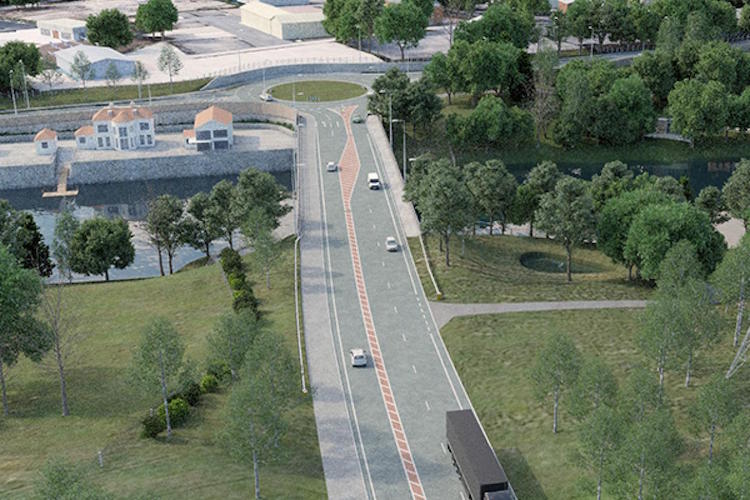
Computer generated view of the terminus of the
proposed bypass seen looking east towards the
existing A4, with the Killyhevlin off frame to
the top right. It shows the proposed layout,
namely a single-carriageway with 2+1 overtaking
lanes at either end. [DFI image from here]
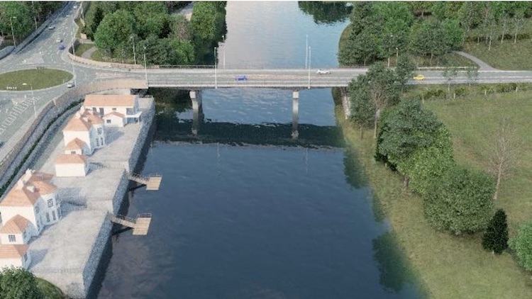
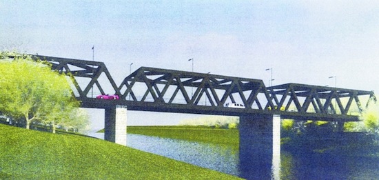
Computer generated view of the proposed bridge
over the River Erne with the exisring A4 on the
left and the Killyhevlin off frame to the top.
In 2013 Fermanagh Council suggested a number of
"landmark" designs for this bridge, including a
box girder bridge designed to be reminiscent of
the former railway bridge nearby, but this
appears to be a slender concrete arch bridge.
[DFI image from here]
14 Nov 2016: In response to a Written
Question (AQW 5213/16-21) in the Assembly
on 26 October the Minister gave slightly more
detail than he did earlier in the month.
Referring to the preparation of the
Environmental Statement and the draft statutory
orders (basically, the various legal documents
that they have to produce in order to proceed to
a likely public inquiry) the Minister said "consultants
have recently been appointed to assist my
Department in taking the project through this
stage". He then went on to say "I hope
to be in a position to announce the
publication of the draft Orders and
Environmental Statement in mid 2017". He
did not give any committments beyond this, ie
did not commit to providing funding to build the
road on any particular timescale, instead just
saying that at that point it will "be
considered for funding, along with other
existing and proposed schemes elsewhere in the
north of Ireland". I would not read this
in a negative way however - this is the position
of any scheme that hasn't got funding yet, so it
merely a statement of reality.
23 Oct 2016: The DRD Minister briefly
commented on this scheme in
the Assembly on 4 October. He said "Work
is ongoing to prepare the environmental
statement and the draft statutory orders. It
is anticipated that those will be published in
2017, which may lead to a public inquiry".
This sounds a bit more certain than the language
used in May (where he said "possibly early in
2017"). Enniskillen is one of two bypasses that
the Minister has specifically mentioned by name
(eg at the very bottom of this
press release) which allows me to
tentatively suggest that this scheme has at
least earned the sympathy of the Minister, which
bodes well. We have to be careful about the
"public inquiry" comment. Once draft orders are
published they usually go out to consultation
and this will take some time. After that,
depending on the comments, a public inquiry may
be called but there's no requirement to do this
in a particualr timeframe so we can't really say
anything about when that might happen. Lack of
money will be an issue for the next few years
since the Executive is prioritising the flagship
projects on the A5 and A6.
2 May 2016: The DRD Minister issued a press
release about this scheme back on 25
February. This is a good example of a press
release that sounds really good despite saying
very little of substance. I struggled to find
anything concrete in it, and the best I can do
is the comment that "TransportNI is now in
the process of appointing engineering
consultants to assist in taking forward the
production and publication of the
Environmental Statement and the draft
Statutory Orders" and then, at the end,
the comment that these "could be in place
early next year". This suggests that the
DRD are continuing their design work and are
going to be publishing the draft "Statutory
Orders", possibly early in 2017. The "Statutory
Orders" are the legal documents needed to build
a road - these consist of the "Environmental
Statement" (which sets out why they think the
road is worth building), the "Direction Order"
(which gives the DRD permission to build a new
trunk road) and the "Vesting Order" (which
compels landowners to sell the land needed to
build it). They are kept in a draft form until
after the public inquiry and, in the case of the
Vesting Ooder, are not activated until shortly
before construction begins. So basically what we
can glean from this press release is that we
"might" have these draft legal orders early in
2017. However, speaking
in the Assembly a few weeks before this
press release the Minister was less optimistic
saying "Further progression of the project,
through the statutory procedures to
construction, are dependent on the
availability of finance. Should finance become
available, it would take around 18 months to
two years before work could start. So it is
still some time off".
28 Jun 2015: The DRD have now published
their preferred route, which was revealed at a
public exhibition on 17 June which approximately
120 people attended. You can download a copy of
the leaflet here,
but I have included my own map showing the
approximate route above. The dates given on the
DRD
web site suggest that this preferred route
was finalised and agreed over a year ago in
March 2014, but has only just been published.
The route is similar to the route corridor
publicised in 2008 (see below), except that it
has been decided at the western end to terminate
the road at a new roundabout on the A509
Derrylin Road rather than extending it all the
way to the western A4. This makes sense since
the A509 is itself a strategic road and links to
the A4 at a roundabout. Since the new bypass
will likely steal the "A4" number from the
current route through Enniskillen, I would also
assume that the short stretch of A509 between
the end of the roundabout and the existing A4
will be re-numbered as part of the A4. At the
eastern end the road will begin at a new
roundabout just to the north of the Killyhevlin
Hotel. This location was chosen partly because
it gives the shortest available crossing of the
Erne river. West of the Erne crossing, the road
hugs the line of some trees, but without passing
through them, mirroring the line of some
existing high voltage power cables. It would be
built to a high standard single-carriageway
standard with one lane each way, plus a section
of overtaking lane at either end. This is known
as a "2+1" configuration. There will be just one
intermediate standard T-junction, to provide
access to farmland. While T-junctions that
permit right turns are not usually provided on
new roads these days, this one is unlikely to be
a problem as the amount of turning traffic is
likely to be extremely low. The road will be
equipped with a segregated cycleway along the
north side. The design suggests that segregated
cycleways will also be provided along the A4
into Enniskillen at the eastern (Killyhevlin)
end, and on the connecting section of the A509
at the western end. The local Impartial Reporter
has
an article on the scheme where it gives a
total cost as £30m-36m, although I have not seen
this figure verified anywhere. The article also
outlines some concerns by local landowners,
specifically the Killyhevlin Hotel. Finally, it
goes without saying that there is currently no
money to build this scheme - see my assessment
of the timescale in the previous update below.
10 Jun 2015: The DRD Minister announced
yesterday that the preferred route for
this scheme had been decided. However, neither
the press release nor the DRD web site can tell
us what the preferred route actually is!
However, there is to be a public exhibition on 17
June in the Ardhowen Theatre. No times are
given in the press release, so I'd suggest
phoning the Ardhowen before setting out to make
sure it is open. The text of the press release
suggests that the route will not be dissimilar
to the map shown above, except that the final
bit connecting the A4 and A509 at the very
western end seems to have been dropped. We'll
find out more information next week when the
exhibition happens. In
the Assembly about six weeks ago, the
Minister was asked about this scheme and he gave
some other useful comments. He said "With
modest funding in 2015-16, the scheme could be
advanced to draft order stage. That would be
the notice of intention to make the direction
and vesting orders and the publication of the
environmental statement. That would facilitate
holding a public inquiry in 2016, if required,
and possibly making the direction order in
2016. Thereafter, the delivery of the bypass
would be dependent on the availability of
finance. In the event that capital funding
becomes available, the bypass could commence
in 2017, with construction taking
approximately 20 months to complete. Landowner
consultations have been ongoing, and the
project is being reasonably well received."
I would treat these dates with a great deal of
caution - there are a lot of "coulds" and
"possibles" here. A public inquiry in 2016
certainly seems plausible, but a construction
start date of 2017 seems highly unlikely given
the speed these things move, the current state
of finances and the number of other competing
schemes, especially the A5 and York Street
Interchange schemes.
18 Dec 2014: The Minister confirmed
in the Assembly that the work to decide
the preferred route of the Enniskillen Bypass is
nearly complete and will be announced "early in
the new year". This will be done in the form of
a public exhibition, presumably somewhere in
Enniskillen, which I will publicise as soon as
we hear where and when it is to be held. The
minister does, however, caution that the
progression of the scheme beyond this point will
be "subject to finance". And I have to say, the
future of finance for road schemes in the
province currently looks bleak as departments
face ever deeper budget cuts.
13 Oct 2014: As stated in previous
updates (see below) the Minister has previously
indicated that the "preferred route" for the
Enniskillen Bypass will be announced before the
end of 2014. In a Question
for Written Answer in the Assembly, the
Minister said "The Stage 2 report identifying
the preferred alignment will be complete in
late 2014. At that point I hope to be in a
position to announce the publication of the
findings of the report and the emerging
preferred route." This sounds a little
close to the wire for 2014, so we might be
looking at the New Year before we hear
something, but it does seem that there will be
news before too much longer. There was no
mention of his previous speculation about the
possibility of having a contractor appointed by
mid 2018 (see April 2014 update below) which was
probably a bit optimistic (although I would be
more than happy to be proved wrong!).
16 Aug 2014: We are getting close to the
time when the DRD Minister indicated, back in
late March, that the preferred route would be
published, but nothing has happened as yet.
However the DRD
web site has had the cryptic comment "Gateway
0 approved by Transport NI Management Group on
9 June 2014" added beside this scheme.
"Gateway 0" means that the scheme has passed a
strategic assessment. In laymans language, this
means that the early work on the scheme has
shown that it would be worth building and has
now been approved in principle. It also means
that the DRD will now proceed to develop more
detailed options. This ties in nicely with the
anticipated publication of the preferred route,
so if there has been no change of plan I would
expect to see some sort of announcement before
the end of the year.
10 Apr 2014: In a Question
for Written Answer in the Assembly two
weeks ago, the Minister was asked about this
scheme. He then elaborated in
the Assembly a few days ago. The preferred
route corridor was announced three years ago in
July 2011, and he said that the more
precisely-defined "preferred route" will be
announced "mid to late 2014". He went on to
confirm that, as we know, the scheme currently
has no funding allocation for construction, so
it's impossible to say for sure when it might
actually be built. However he did present a
timescale of sorts by saying that there would be
"potentially, a public inquiry, which could
commence as early as 2016" and thereafter
"if everything were to go well, we
would be looking at procurement and possibly a
contractor in place by mid-2018." It's
always risky for Ministers to say things like
this, so I would tend not to put too much
significance on this date, but instead to treat
this as the minimum timescale, ie it
will not happen before mid 2018. Finally, he
gave a cost estimate of £20-30m, which is
essentially unchanged from the estimate given in
July 2011.
28 May 2013: As far as I can tell, very
little has happened on this scheme since the
last update in 2011. That has not prevented
Fermanagh District Council, who are fierce
champions of this scheme, from working away on
their own ideas for the scheme. Last week the
Impartial Reporter reported that the
Council has published some suggested designs for
the Erne Bridge section of the bypass, which
they estimate to cost between £8.4m and £11.6m.
One is shown below. The Council describes it as
important to take forward a major capital
project to provide a "positive legacy" for
hosting the G8 this June, even going so far as
to suggest calling it the "G8 Bridge". Since the
Bypass is a project being taken forward by the
Department for Regional Development, not
Fermanagh District Council, these proposals are
really nothing more than the council's
suggestions, rather than being actual proposals
from the project's engineers. In addition, the
scheme is still at an early stage and is quite
low down on the DRD's list of priority, so
construction is likely to be many years away
yet, long after the G8 has passed into the pages
of history. (Note: towards the end the article
says that the "bridge" is estimated to cost
£19.2 to £31.9 million, but this actually the
cost that the DRD have estimated for
construction of the whole bypass, not
the bridge element on its own.) With thanks to
Bens33 for alerting me to this news article.
One of Fermanagh District Council's proposed
designs for the Erne bridge, this one being a
rather imposing box girder structure.
12 Aug 2011: The previous
update linked to the State 1 Assessment
Report which I didn't have time to
comment on in late July. It reveals that the
planners considered two routes. The one shown on
the map above is the originally indicated
"inner" route, and it was joined by a second
"outer" route further out from the town (south
of the Killyhevlin Hotel). In each case there
was a "short" version of the route that went
from the A4 Dublin Road to the A509, and a
"long" version that continued to the A4 Sligo
Road. The "outer" route performed poorly in the
benefits-cost analysis (ratio of 0.38 for the
long option, and 0.82 for the short). As both of
these are below 1, it implies that that option
would bring fewer benefits than it would cost,
mainly because its distance from the town at the
eastern end would discourage local traffic from
using it. The "inner" route, which begins north
of the Kilylhevlin Hotel, performed much better
(ratio of 1.43 for the long option, and 2.26 for
the short). The planners therefore recommended
that only the "inner" route be considered at the
next stage of the analysis. Even this option has
a couple of possible locations for the major
bridge that would be required over the Erne. The
document does note that one of these two
locations was previously home to a railway
bridge (since mostly demolished) and that the
new bridge could be built in a similar style as
a nod to the past history of the area. The
decision as to whether to go with the "short" or
the "long" version of the route is still
undecided. The A509 currently connects to the A4
Sligo Road via a roundabout, so it would not
strike me as a major problem if the Southern
Bypass were to stop on the A509 rather than
continuing on to the A4. The only disadvantage
would be one extra roundabout to navigate, and a
significant increase in traffic on the short
shared stretch of the A509.
27 July 2011: The preferred
route corridor was announced
today. I won't be updating the site for the next
fortnight and as I don't have enough time
tonight to give a proper analysis of the
announcement, I recommend you look at the
documents here,
particularly the Executive Summary. The
preferred route is broadly in agreement with the
green line on the map above. I will give a more
comprehensive update in August. According to the
press release a public display of the preferred
route to be held "in the Town Hall, the public
library and the Roads Service Section Office at
Castle Barracks in Enniskillen from Wednesday 27
July up to Wednesday 31 August 2011".
4 Jul 2011: As far as I am
aware, the public consultation anticipated for
last Autumn did not take place. Instead, the Minister
has now said that a public exhibition of
the preferred route for the Southern Bypass will
take place in Enniskillen "in July 2011",
although no actual date, time or venue is given.
These exhibitions are often held with only a few
days' notice online, so I will keep an eye out
for any announcements. The Minister cautions
that there is currently no money to actually
build this road, so for now it will remain a
future plan.
22 November 2009: According to
this
press release, Roads Service are planning
to hold a public consultation event in "Autumn
2010" to reveal the general route corridor
(note: not the actual route) that is being
proposed for the Southern Bypass. Meanwhile, the
Impartial Reporter has published
an article reporting that Roads Service
are exploring the possibility of introducing a
one-way system in the town to ease traffic in
the interim, while the Southern Bypass is being
planned. (With thanks to Gary Potter).
7 June 2009: At a meeting
with Fermanagh District Council two weeks ago,
Roads Service confirmed that they have now
appointed consultants to commence route
selection work. Construction is still unlikely
to commence before 2013, and perhaps not until
2018.
24 Nov 2008: Roads Service released
a leaflet in October 2008 which includes a
map that provides the first indications of the
route that is being considered (see below). It
does not give any other information on the
scheme, other than to confirm that construction
is anticipated between 2013 and 2018.
Map of the proposed route of the
Enniskillen Southern Bypass as of October 2008.
(Map
not exactly to scale; based on Google Earth
imagery)
Photos
The
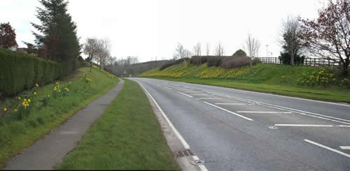
existing A4 Dublin Road, seen looking south,
from opposite the Killyhevlin Hotel in March
2007. This image was taken from the Geograph
project collection. See this
photograph's page on the Geograph
website for the photographer's contact
details. The copyright on this image is owned
by Kenneth Allen and is licensed for reuse
under the Creative
Commons Attribution-ShareAlike 2.0
license.
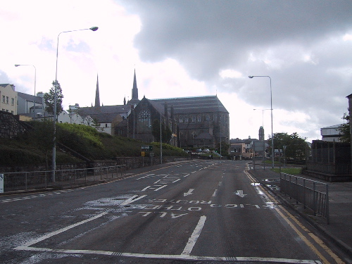
The
existing A4 Enniskillen Throughpass (here caught
early on a Sunday morning in 2002) carries the
A4 parallel to the town centre but this route is
increasingly congested at peak times. [Photo by
Wesley Johnston]
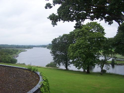
The
Erne as seen from the Kilyhevlin Hotel,
Enniskillen in 2008. The new road will have to
cross the Erne very close to here, probably to
the right of this shot. [Wesley Johnston]
|
