|
|
Status
|
Construction scheme
(future) |
|
Scheme
|
Construction
of a new route taking through traffic on
the A24 Belfast to Newcastle route out
of the town centre. |
|
Total
Length
|
3.1km (1.9 miles) |
|
Dates
|
2002 - Regional
Transport plan commits to construction
by 2015.
June 2005 -
Government announces funding to begin
statutory processes.
Dec 2005 -
Consultants appointed for route
selection.
Mar 2006 - route
included in Sub-Regional Transport Plan
2007 - preliminary
route published
12 Nov 2009 -
preferred route announced
14-15 Apr 2015 -
Public exhibition of preferred option,
with comments accepted from 25 Mar to 19
May 2015.
26-27 Jan 2016 - Public inquiry took
place
13 Dec 2016 - Departmental Statement
published [decision to proceed]
Jun 2023 - Scheme was to go out to
tender (as of Oct 2022, changed from Dec
2021 as of May 2021) but then paused in
August 2023
Mar 2023 - Scheme "un-paused"
2027/28 - Scheme to go out to tender
2028/29 - Construction to begin, due to
last about two years (as of Mar 2025)
2030/31 - Completion if the above
schedule is kept
|
|
Cost
|
£50-60m (as of Mar
2025)
revised from £35-40m
as of Jun 2018; £35m as of Dec 2016;
£40m-£50m as of Jan 2012; £36.4m
as of Feb 2009, £12.1m as of Oct 2007,
and £10.8m as of 2005 |
|
See
Also
|
General
area map
Official web
site on scheme - DFI Roads
|
Click
here to jump straight down to updates
for this scheme.
Vehicles travelling from the Belfast
metropolitan area to the popular resorts around
Newcastle must negotiate Ballynahinch town
centre with a series of chronically congested
junctions. This not only frustrates drivers who
are part of the through traffic, but increases
tension and danger for those living, shopping
and working in the town. The proposed bypass
will run round the eastern periphery of the town
with one intermediate grade-separated junction
at Crossgar Road. Housing is being permitted up
to the line of the road, but no further. The
scheme has been proposed since the 1960s.
Route and Standard
The map below shows
the approximate route as proposed in March 2015,
including an indication of the layout at the
Crossgar Road grade-separated junction. Click
here for a more detailed map of the
proposals (link correct Jan 2016).
The bypass will start north of the town at a
new roundabout on the A21 / A24 junction where a
Park-and-Share site may also be constructed. For
the first 660 metres there will be two lanes
southbound and one lane northbound. After this
it reverts to one lane each way. The road will
pass under Moss Road without connecting to it.
There will then be a grade-separated junction
with the B7 Crossgar Road. The final 515m of the
road will feature two lanes northbound (to allow
overtaking) and one lane southbound. The bypass
will terminate on a new roundabout at the
junction of the existing A24 with the B2
Downpatrick Road.
Updates
8 Oct 2025: In a report
to Newry, Mourne and Down District Council two
weeks ago, DFI said that they are re-examining
the design of the project due to the fact that
it has sat for nine years since it passed its
public inquiry in 2016, which is a long time in
infrastructure terms. So "it will have to be
reviewed and where necessary updated to
current standards and conditions". The
"it" certainly includes engineering standards,
but also assessment standards, including
requirements under things like the Habitats
Directive and the Climate Change Act, both of
which have been tested in court in the interim.
So I'd expect the design to evolve. Depending on
the scale of changes this may or may not lead to
another public inquiry. DFI also said that the
funding of this scheme is tied to that of the A1
Junctions Phase 2 project. More specifically, it
seems that the restrictions of the funding
stream mean that this scheme can't commence on
the ground until the A1 project has been
underway for at least two years
(otherwise they'll get too many bills at once).
Hence the earliest the scheme could begin is
spring 2028. This is unchanged from the
timescale the Minister quoted in the spring.
Note that this timetable is based on finances,
it doesn't take account of other matters that
might delay the project, such as the
aforementioned possible public inquiry. So I'd
regard that as an "earliest possible start date"
rather than a "predicted start date".
19 Mar 2025: Having been "paused" by DFI
eighteen month ago (while Stormont was
suspended) the scheme got a sudden new lease of
life on 12 March when the DFI Minister Liz
Kimmins made
a statement about the scheme. She said
that work will begin to "review and update
the necessary documents to bring this scheme
to procurement, including the finalising of
the Business Case" and that this work will
take "in the region of two years". I don't think
this work would normally take two years to
complete, but I think the scheme timetable is
constrained by the availability of funding. The
Minister said that the scheme would be "managed
sequentially to the A1 Junctions [Phase 2]
project". This implies that construction
on the Ballynahinch Bypass will not begin until
the A1 Junctions
Phase 2 project is completed, or at least
well progressed. This is presumably because
there isn't enough cash to built both at once.
Work on the A1 scheme is due to begin in spring
2026 and take three years, meaning that it would
be due to be completed by early 2029. This is in
keeping with the Minister's statement that work
on the A24 Ballynahinch Bypass "could
commence in 2028/29". So I would therefore
expect the scheme to go out to tender in two
years' time (sometime in 2027) and, because the
tendering process typically takes about a year,
that could see construction to get underway in
2028. But knowing how these things usually slip,
I would say 2029 is more likely, with completion
then in 2031. Note that the cost estimate in
2018 was £35-40m, but DFI are now quoting a
figure of £50-60m. This is likely to be higher
still by the time we get to 2027 as construction
inflation is still running high. The only other
risk to the scheme is that the Public Inquiry
was now nine years ago, so it would be important
not to make any changes to the design
significant enough to trigger another public
inquiry.
17 Apr 2024: A Horrific
road death that occurred in Ballynahinch
town centre a week ago has prompted an online
petition to appeal for the proposed Ballynahinch
Bypass to be built. The official position is
that this scheme is "paused", as of 2023, due to
the significant financial pressure on DFI's
capital expenditure. You can see the petition here.
18 Aug 2023: DFI Roads this week released
a document showing how the current roads
programme will be prioritised in the current
economic and legislative climate, where DFI is
now required to de-carbonise transport. Of the
three bypasses in the previous list (Cookstown,
Ballynahinch, Enniskillen) only Cookstown
and Enniskillen
made the cut, while the Ballynahinch Bypass is
now "paused". The reason for this is likely that
both Cookstown and Enniskillen stand to get
funding through the Mid South West Region Growth
Deal, whereas Ballynahinch does not have any
source of funding. The scheme must now await the
publication of a new suite of regional transport
plans currently in development. Whether the
Bypass happens will depend on whether it is
included in these future plans, and of course on
availability of funding. The scheme is
shovel-ready, having passed its public inquiry
in 2016, but was already looking shaky earlier
this year (see previous update below) when it
got no funding allocation for 2023-25. It is
important to note that this announcement does
not mean that the scheme won't happen, but it
does put a question mark on it and puts it on
the long finger for the time being.
4 Jan 2023: This brief update is simply
to say that in the absence of a functioning
Executive, and with a draft budget that does not
provide any funding for this scheme before 2025
anyway, I think it is fair to regard this scheme
as being "on hold" until at least 2025.
Therefore I don't expect much more to happen in
the next couple of years. The only things that
might change this would be if the Executive was
restored in the interim (may or may not happen),
or if a budget was set from Westminster which
somehow funded this scheme (unlikely in the
current climate).
27 Oct 2022: In a report
to Newry, Mourne and Down District Council this
week DFI provided an update on this scheme.
Surprise, surprise nothing much has happened to
progress the scheme since May 2021, mainly
because there is no funding to build it. The
only thing that is going on is a study into
"active travel" measures that could be
implemented within the town centre on the bypass
is complete. The Investment Strategy for NI web
site, which rarely gives meaningful
information these days, has put the release of
the construction tender back from December 2021
to June 2023. This too, however, is unlikely to
happen as there is no functioning Executive and
even the draft budget doesn't envisage any
funding being available before 2025. The report
to the council simply says "progression to
construction will depend on budget allocations
made to the Department in future years",
which is literally all that they can say at this
point. So unfortunately I would not expect to
see work beginning on this road in the next 2-3
years. Sorry that this update is so gloomy!
5 May 2021: The DFI Minister announced
in mid-April that she was making the Direction
Order for the Ballynahinch Bypass, as she had
indicated in November (see previous update
below). This is the document that effectively
gives DFI permission to build a new trunk road.
This does not mean that work will begin. Two
things are still needed - firstly, there needs
to be an allocation of funding from the
Executive, which has not yet been made
available, and secondly DFI needs to "make" the
Vesting Order, which is the legal document that
transfers ownership of the land required to DFI.
There is still no indication of when funding
might come available, but the Investment
Strategy for NI (ISNI) web site is now
listing this scheme as to go out to tender by
December 2021, a delay of nine months from the
dates it gave in November 2020. If this
timescale sticks (which it may not if there's no
money) construction would begin in December 2022
and end in September 2024. However, the ISNI
seems to repeatedly kicking the timescale can
down the road, which suggests that nobody really
knows.
29 Nov 2020: In a question for Written
Answer the DFI Minister said that this
scheme "is now at an advanced stage of
development and preparatory work on contract
documentation has been completed". She
went on to say "I have asked officials to
complete the work necessary to allow me to
make the Direction Order. This includes a
review of the environmental reports which is
nearing completion and, subject to the outcome
of the review, I hope to be in position to
make the Direction Order for the scheme in the
new year." The Direction Order is the
legal document that permits the DFI to construct
a new trunk road. The scheme has already passed
its public inquiry and DFI already formally
decided to proceed to construction back in 2016,
so all that's needed now is funding from the
Executive. The Investment
Strategy for NI web site is listing this
scheme as to go out to tender by March 2021,
which is a slight slip from the position a year
ago, but not much. DFI therefore appear to be
quite confident that funding will be
forthcoming. The scheme had a particular fan in
the previous DFI Minister, Chris Hazzard, so
there does seem to be cross-party support for
it. In conclusion, the Ballynahinch Bypass does
genuinely seem to be edging closer to actual
construction, and I'd expect to see a tender
process get underway during 2021 and, in a fair
wind, construction begin sometime in 2022.
12 Jun 2020: Nine months ago (below) I
reported that this scheme seemed a good
candidate to be progressed once Stormont was up
and running. The DFI Minister announced her budget
for the next year, which allocated money to the
Executive's flagship projects (A5, A6 and
Belfast Transport Hub) but did not give any
funding for any other capital road schemes,
including the Ballynahinch Bypass. However she
followed this up today with a press
release clarifying that she had approved
funding for the continuation of planning of
several planned road schemes, including the
Ballynahinch Bypass. So I would read this as the
Minister saying that she does not have the funds
to construct the Bypass in the near future, but
that she does regard it as one of the schemes
she hopes to progress once the "flagship"
projects have been progressed further. This
confirms the view that I expressed in the
January update below.
7 Jan 2020: It has been eighteen months
since the last update. In that update (below) I
said that the ISNI web site was suggesting the
scheme would go out to tender by September 2019,
but cautioned that this was probably not a
reliable date. This has proven correct, with
nothing happening in the interim. The ISNI web
site is now
stating that the tender process will
commence by December 2020 with construction
taking place between December 2021 and December
2023, ie 24 months (as opposed to 21 months). As
I said in 2018 I believe that this scheme -
along with the Enniskillen Bypass - is regarded
as a high priority within DFI and, if Stormont
is restored, it may well be one of the next of
the "non-flagship" schemes to get the go-ahead.
For now, note these dates but don't quit the day
job.
23 Jun 2018: This scheme is more or less
shovel ready, having successfully gone through
all its statutory processes. All it needs now is
the final legal orders to be made, a tendering
process - and then a big pot of cash. On this
latter point, the Investment
Strategy for Northern Ireland Pipeline
contains an entry suggesting that this scheme is
to go out to tender by September 2019 with a
total project cost of £35-40m. The information
goes on to suggest a contractor would be
appointed by March 2020 with construction taking
place between June 2020 and March 2022, ie 21
months. This sounds exciting, though it's worth
commenting that without a functioning Executive
it's hard to put much certainty in this sort of
thing. What we CAN deduce is that this scheme is
regarded as a high priority once the current
flagship projects are underway (A5, A6, York
Street). The only other non-flagship schemes
that seem to be operating to this timescale are
the A4
Enniskillen Bypass and the A1
Junctions Phase 2 project.
22 Mar 2018: Somehow or other, work
continues to progress on planning for this
scheme despite the lack of a Minister.
Geotechnical work took place in late 2017, and
at the start of March a contract for
archaeological survey work along the route of
the road began (as spotted
by this infrastructure fan). The scheme found a
champion in the previous DFI Minister, Chris
Hazzard, and is in an advanced state with the
public inquiry passed and the Departmental
Statement published. That means it could begin
with just a few months notice if funding were to
become available (which seems unlikely in the
next 2-3 years).
30 Nov 2017: The October
report to Newry, Mourne and Down District
Council indicates that "A programme of
geotechnical investigation works on lands
along the length of the scheme has recently
been completed". This means things like
boreholes to find out much more precisely what
the ground beneath the road is like, and is
necessary when moving into the final design
ahead of construction. At this point in time the
scheme has no funding allocation, and is
unlikely to get one for at least three years
since all DFI's new road budget is going into
upgrading the A5 and A6. So I don't think it's
likely that we'll see work begin on this road
before 2020 at the earliest.
1 Jan 2017: This scheme had its public
Inquiry in January 2016, and the Inspector
submitted his report in March. The DFI has been
examining this and on 13 December 2016 the
Minister made a statement
where he announced that the scheme had passed
the Inquiry and would proceed to the next stage,
namely the creation of the necessary legal
orders. The Inspector's report and the DFI's
response to it (the "Departmental Statement")
can be viewed on the DFI
web site. Having read the Inspector's
report, it's clear that there are very few
changes to the design as a result of the
inquiry, so it will be proceeding more or less
as planned. The Minister has also given the cost
of the scheme as £35m, which is considerably
cheaper than the estimate of £40-50m five years
ago, in January 2012. If that is accurate, then
it is very good news indeed. As always, the big
unknown is money. Currently no funding has been
allocated to the Ballynahinch Bypass so that
means that the scheme will now go onto the
waiting list until such times as it does get
funding. There is no clear indication when that
might be, though I do get the impression that
the Minister is at least sympathetic to this
scheme.
23 Oct 2016: The new Minister, who has
been in office since May, has made it clear that
his priorities are the A5 and A6. However, while
he has been circumspect about what other roads
he wants to progress, he has specifically
mentioned two bypasses by name - Enniskillen and
Ballynahinch (eg at the bottom of this
press release). This suggests that the
Minister is sympathetic to this scheme which
bodes well for those who wish to see it built.
The fact that the Minister himself is from
Ballynahinch (Drumaness, to be exact)
means he will have first hand knowledge of the
problems that through-traffic causes for this
town.
30 May 2016: Hot bank holiday weekends
serve, at the very least, to remind the general
population of the great need there is for a
bypass of Ballynahinch, which was gridlocked by
through-traffic over the past few days. This
Department for Infrastructure report (DFI,
which has now replaced the Department for
Regional Development) notes that the Inspector's
Report into the Public Inquiry that sat in
January has now been received by the DFI
[March]. Normal procedure is the Inspector's
Report is not published until the DFI have had
time to digest its findings, and after a number
of months (or years, in the case of the A6!)
they release both the Inspector's Report and
their response, the Departmental Statement,
simultaneously. No timescale has been given, so
I would expect to hear nothing more for some
months. It is also worth noting that the scheme
currently does not have a funding allocation.
This means that, even when design work is
completed, it will not proceed to construction
until such times as the Executive gives it
funding.
24 Feb 2016: In the Assembly on Monday
the DRD
Minister said that the Public Inquiry
lasted two days - 26 and 27 January. She
confirmed what I said below, that the Inspector
will probably submit his report within a few
months. She also commented that the earliest
possible start date is "early 2018". While
probably just about doable on that timescale if
everything was progressed at full speed, I think
it is highly unlikely to take place within that
timeframe given the other projects around the
province that are competing for funding in the
coming years. Since the Inspector's Report is
not made public until after the DRD has spent
several more months considering its content, I
would not expect to hear much more about the
Ballynahinch Bypass until the autumn at the
earliest.
31 Jan 2016: The Public Inquiry into
this scheme took place this week, beginning on
Tuesday 26 January. I don't know whether the
Inspector saw all the evidence on one day or
whether it had to sit on one or more additional
days. The evidence that the DRD presented
(basically, their case for building the bypass)
is now online
here. The next stage is for the Inspector
to present their report to the DRD, a process
that normally takes a few months. The report is
not made public at this point. After that, the
DRD works on its reaction to the report and will
then release their official response, called the
"Departmental Statement", along with the Public
Inquiry Report. This normally occurs a minimum
of about nine months after the Inquiry, but it
can sometimes take several years if the DRD is
not ready to say more straightaway. In December
2015 some money was allocated to road schemes
for the next five years. Nothing was allocated
to this scheme. However, that does not rule out
the scheme progressing in that timeframe, since
this allocation did not necessarily consist of
ALL the money that will be available for roads
during the next five years, but merely money
that has been definitely allocated. In December
2013 I said that in a "best case" scenario work
could get underway in 2018. This is still
technically true, but strikes me as unlikely now
because priorties for the next couple of years
seem to lie elsewhere (A5 and A6).
9 Nov 2015: The (new) DRD Minister announced
last week that the Public Inquiry into
this scheme will be held in late January,
beginning on Tuesday 26 January at the Millbrook
Lodge Hotel, 5 Drumaness Road, Ballynahinch. The
press release notes that 36 responses (23
objections, 5 supportive, 8 neutral) were
received to the proposals which were put out for
consultation in April (see previous update).
Coinciding with the announcement of the public
inquiry, the DRD has also published
further documents including the draft
Vesting Order (detailing the land they intend to
buy to build the road) and the Departmental
Statement (which formally sets out what they
want to build and explains why they think
it would be a good investment). The Public
Inquiry is another necessary hurdle for a scheme
like this, but even if the road passes the
inquiry (and almost all do) construction will
not begin until the Executive gives the scheme
specific funding. So we still can't say much
more on possible timescales, except that I
anticipated in the December 2013 update below
that in a best-case scenario, work
could get underway in 2018.
25 Mar 2015: The DRD Minister has launched
another public consultation into this scheme.
The scheme has advanced to the point where a
"final" design is now ready, and this will be
displayed to the public at a public exhibition
in the Market House, Ballynahinch on Tuesday 14
April from 12.30pm to 9pm and Wednesday 15 April
from 10am to 9pm. Technically what has been
published are drafts of the Direction Order
(a short document that gives the DRD permission
to build a new trunk road), the Environmental
Statement (an enormous document that
details almost everything about the scheme and
its impact) and the Vesting Order (that
gives the DRD the right to buy the necessary
land). All this documentation is available online,
but if you want the "bottom line", this
is a link to a summary which includes a
map at the end. We have known for some time that
the DRD had decided to place a junction where
the Bypass meets the B7 Crossgar Road (see
update below for 25 Jan 2012), but it now looks
as if we are going to be treated to that rare
beast, a grade-separated junction on a two
lane road. A grade-separated junction is
one where traffic on the main road does not have
to stop, and the side road passes above or below
it via a bridge (example).
Sliproads then take vehicles down onto the main
road. They are ubiquitous on motorways, common
on dual-carriageways but rare on roads with only
one lane each way. The more usual approach is
either a roundabout or a standard T-junction,
but the DRD must have decided that neither is
appropriate - the former slows traffic down, and
the latter involves right-turns. So that is one
element of this scheme that is quite
interesting. The maps suggest that what will
happen is that there will be a short stretch of
central barrier through the junction (presumably
to stop people turning right as a shortcut) but
with one lane each way. Click
here to see a map of the proposed Crossgar
Road junction (link correct Mar 2015). The
public can make comments up until 19th May,
after which the Minister may decide to convene a
public inquiry. One note of caution - there is
currently no budget to build this bypass, and no
specific commitment to provide the funding
either, so at this point the scheme is still
only a proposal.
8 Dec 2013: According to a Question
for Written Answer to the DRD Minister on
8 November (question ref AQW 27458/11-15), the
DRD Minister minister expects to "publish
draft statutory orders in 2014/15". These
are the legal documents that DRD need to make in
order to get permission to build a new trunk
road and do things like buy the required land.
They're called "draft" because they are then
usually subjected to a public inquiry. The
Minister's comment means that the scheme could
have its public inquiry in 2015. Once/if the
scheme passes the public inquiry then the actual
versions of the legal documents get created.
This is what the DRD Minister means when he goes
on to say "...with a view to making those
orders in 2016/17". This means that,
allowing perhaps six months for the inquiry
inspector to present their report, and perhaps a
year for the DRD to study it and respond to any
recommendations, the scheme could be ready
for construction in late 2016 or 2017. This
doesn't mean that construction would actually begin
at that time, as the scheme must then join the
list of schemes that are competing for funding
from the Executive, and this final hurdle will
depend entirely on the priorities in the
Executive at that time. So in a best-case
scenario, where the scheme immediately gets
funding and goes through a procurement process
(normally about 9 months) construction could
begin in 2018.
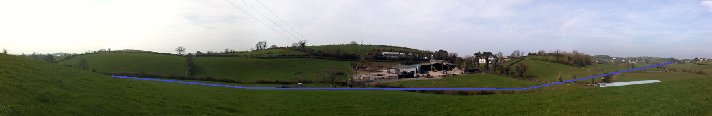
28 May 2012: A site visitor (who prefers
to remain anonymous) has taken a
panorama of the route of the new road. The
panorama is taken from approximately
here, and shows around 180° looking
generally west. He has marked the
approximate route of the road in blue. Click
here to see the image. Many thanks for
this. There is no other news on this scheme.
25 Jan 2012: According to an announcement by the
Minister during
a debate in the Assembly yesterday,
Roads Service approved the Stage 2 preferred
options report for this scheme. This means
that they have now decided on a finalised
route and junction strategy - it doesn't
mean than anything will happen on the ground
any time soon. As yet no material on the
subject has appeared on the DRD web site, so
we are limited to reading the Minister's
statement. The route is 3.1km (1.9 miles)
long, and from the description appears to be
more or less the same as the preferred route
option announced in November 2009. The only
significant change from the 2009 route is
that there now WILL be an intermediate
junction, at B7 Crossgar Road. The previous
plan had been for a bridge over or under the
B7 at this location, so this may mean either
(a) a short stretch of link road to link
between the two, or (b) replacing the bridge
with a roundabout. This change was requested
during the public consultation. Normally
Roads Service resist adding intermediate
junctions on new strategic routes as it
tends to attract local traffic that should
be on the local road network, but in this
case Roads Service appear to have acquiesced
on the grounds that its provision would
actually transfer a substantial number (670)
additional vehicles per day to the Bypass
(which is predicted to carry 6,500 per day
when opened). These vehicles would otherwise
continue into the town centre, hence the
provision of the junction would improve
congestion in the town. The Minister
concluded by stating that the estimated cost
has risen, this time to £40m-£50m. This
compares to the estimate of £36m three years
ago. The new junction at Crossgar Road is
the only significant change since then, but
it's hard to see how this could add as much
as £4m-£14m to the total cost, so other
factors must also be at play. The debate in
Stormont highlighted the local demand for
this road, but the timescale is unchanged.
The official position is still that
construction will take place between 2014
and 2019.
6 Mar 2010: The preferred
route was announced at a public exhibition held
in the town on 12 November 2009. The exhibition
must have been carried out in stealth, as no
press releases were carried on the DRD web site,
and the material has not appeared online since
then! Anyhow, it shows the preferred route to be
3km long, around 2/3 of which will be built to
2+1 standard (one lane one way and two in the
other) and the rest with one lane each way.
There will be no intermediate junctions, which
is very sensible for a road whose whole point is
to be a "bypass". Skipping intermediate
junctions will allow it to remain a bypass and
not be used by local traffic that really ought
to remain on the local road network. There is no
further information on timescale.
18 Oct 2009: According to this
press release Roads Service plan to
announce the preferred route for this scheme
"within the next few weeks". This follows the
release of route options during 2007. The scheme
is currently timetabled for construction in 5-10
years time.
12 April 2009: In the minutes
of the Roads Service board meeting on 26
February 2009, there is the following
comment: "sought amendments to the original
proposal for Ballynahinch Bypass and noted the
consequent reduction in estimated cost from
£46.7 million to £36.3 million. On that basis
the Board gave Gateway 0 approval to the
Eastern Corridor Route Option A and granted
permission to proceed to Gateway 1." Both
these values are considerably more than the
value last publicised (£12.1m in October 2007).
It's unclear from this statement what exactly
the current design is, or what "Eastern Corridor
Route Option A" might refer to. But at the very
least it suggests that the project is still
being actively pursued.
2 February 2009: According to
a press
release issued in early December 2008,
progress on the scheme is awaiting the outcome
of the public inquiry into the Ards/Down Area
Plan 2015. The inquiry was held between May 2005
and January 2007, and the Planning department is
now considering a report by the Planning Appeals
Commission, a process that is not yet complete.
According to the Regional Development Minister,
"It is the intention to propose the
Ballynahinch Bypass scheme to preliminary
public consultation as soon as practicably
possible once the outcome of the public
inquiry into Ards/ Down Area Plan 2015 is
known. Meanwhile Roads Service is carrying out
essential development to ensure it proceeds
through statutory procedures." See the
links at the top of this page for a link to the
latest information on the Ards/Down Area Plan.
In November 2008 Roads Service released
a leaflet about the scheme that revealed
that the road might be built to 2+1 standard
with a northbound overtaking lane, although this
is not yet certain.
June 2005:
In June 2005 the central UK government announced
£2m of funding for the scheme and in December
2005 a press
release revealed that consultants had been
appointed to select a route.
|
