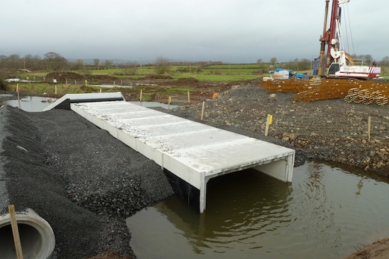
This is a sub-page of the main A8
dualling scheme page. It holds project
updates from the planning stages back in 2007
right through to January 2014, when the
project was roughly half way finished.
Progress
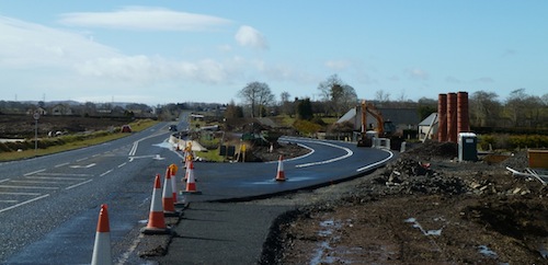
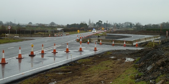
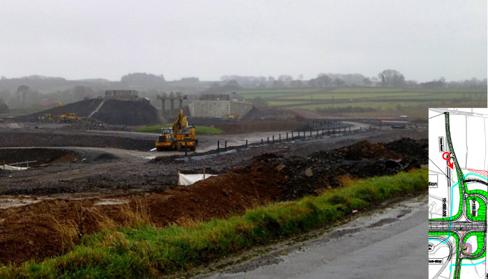
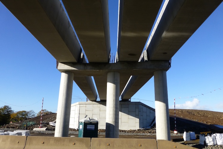
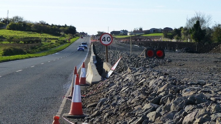
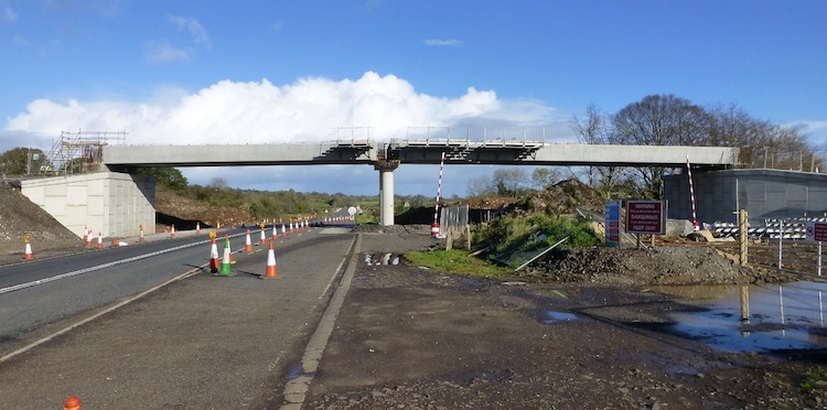
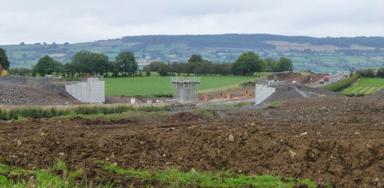
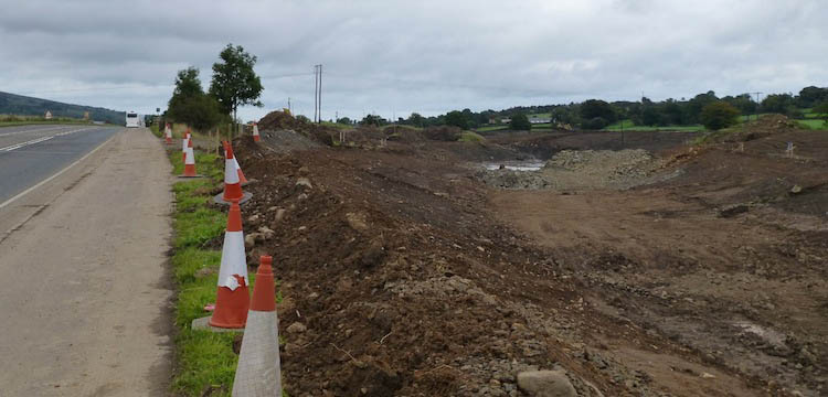
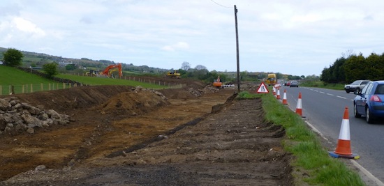
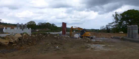
28 Jan 2014: Despite the
dark, wet winter days the scheme continues to
make progress. From the point of view of
motorists, the most visible change is the
addition of the final bridge beams at the Moss
Road flyover which took place about ten days
ago. That means that all three of the flyovers
OVER the A8 now have their beams in place.
However, work continues to take place all along
the A8. The contractor Lagan Ferrovial Costain
has published the third issue of their
informative A8 newsletter, available
here which details some of the work that
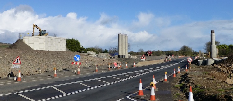
has happened. The front cover has a lovely shot
of the beams being lifted into place at the
flyover that will carry the A57 Templepatrick
Road over the future dual-carriageway near
Ballynure. The newsletter says that the major
culverting works are now completed, and
attention has turned to removing the old
culverts. Rock extraction work has continued
through the winter, and the first kerbs and road
surfacing have been laid. The article confirms
that only one major bridge has not yet begun -
it's the bridge that needs to be built to carry
a sliproad UNDER the existing A8 at Ballybracken
Road, just north of Ballynure. This will
presumably require all traffic to be diverted
off to one side, and work will commence here in
February. The scheme still seems to be on
schedule for completion in March 2015.
Meanwhile, in
the Assembly the DRD Minister has
confirmed that an EU grant of €18m (£15m) has
been gained for the project, covering a bit more
than 10% of the total cost. We already knew
this, but the Minister added that it will be
paid in three parts - £4m in Dec 2013 just
passed, a second installment in the 2014/15
financial year and the balance upon completion.
Anyway - time for the pics! The pictures below
were, with one exception, all taken by Noel
O'Rawe on 19 January, but it's taken me a few
days to get them up. They're arranged in order
from south to north (the Larne end). Remember,
if you want see detailed design drawings you can
download
the full set of plans here [11MB].
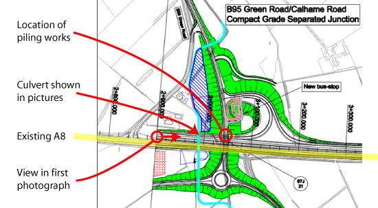
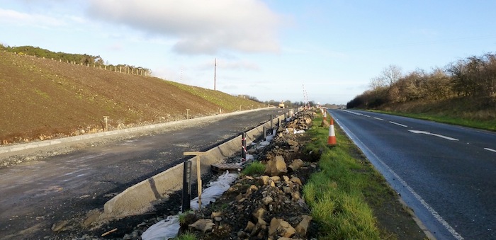
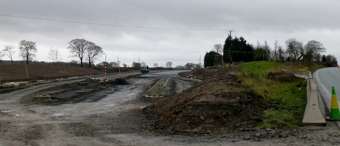
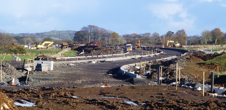
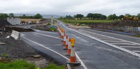
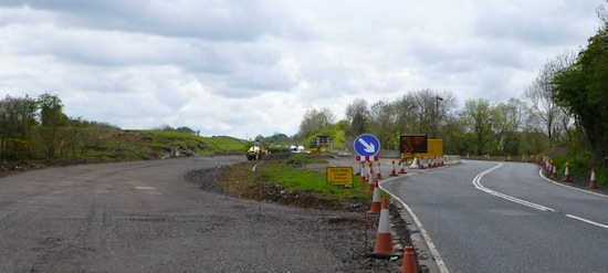
Pic 1: The view along the future A8 from
Coleman's Corner on 19 Jan 2014. Not much has
changed since last month, but it looks as if it
would not take much work to open this short
stretch that bypasses Bruslee. [Noel O'Rawe]
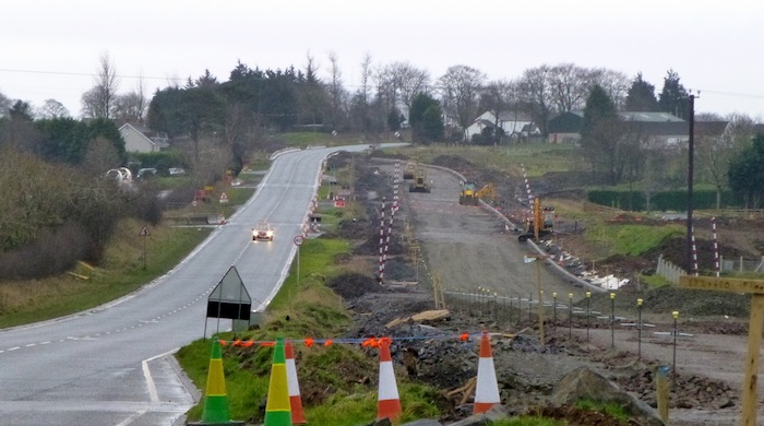
Pic 2: View south along the future A8 "Bruslee
bypass" stretch on 19 Jan 2014, clearly showing
the progressive layer structure that makes up
the final road surface. On the right is part of
a future layby. [Noel O'Rawe]
Pic 3: View of the A8, running left-right ahead,
from Drumadowney Road. This road was previously
a standard T-junction, but in keeping with the
policy of banning right turns on the new road,
it has been converted to left in/left out only
by the large triangular traffic island ahead.
The road is currently closed. Seen on 19 Jan
2014. [Noel O'Rawe]
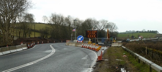
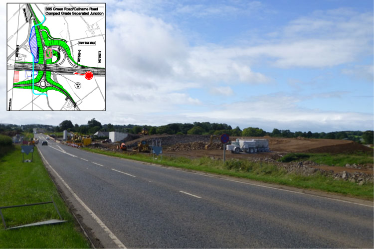
Pic 4: View north along the A8 through the
Calhame Road/Green Road flyover. The current A8
is on the right. On the left is the future
northbound carriageway. You can see how it's
being dug down into the hill. This is to provide
better sight ahead, and hence reduce the risk of
collisions. Lowering the crest of the hill like
this is part of a concept called "vertical
geometry". 19 Jan 2014. [Noel O'Rawe]
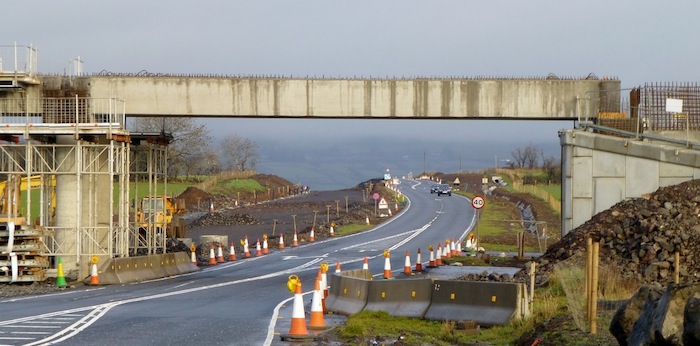
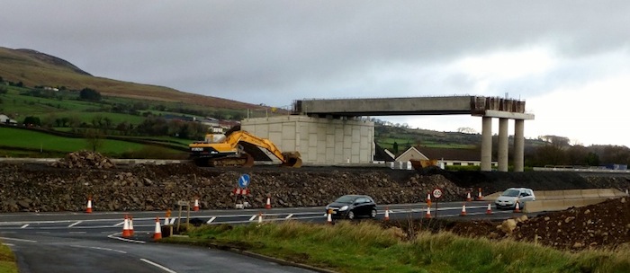
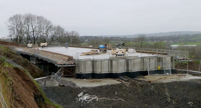
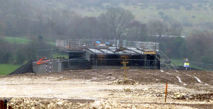
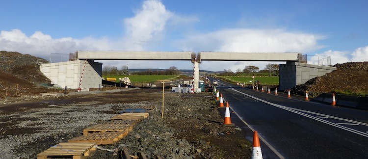
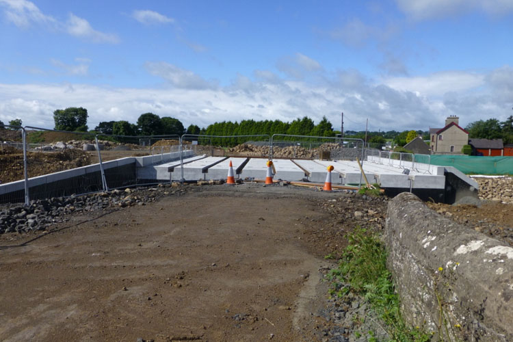
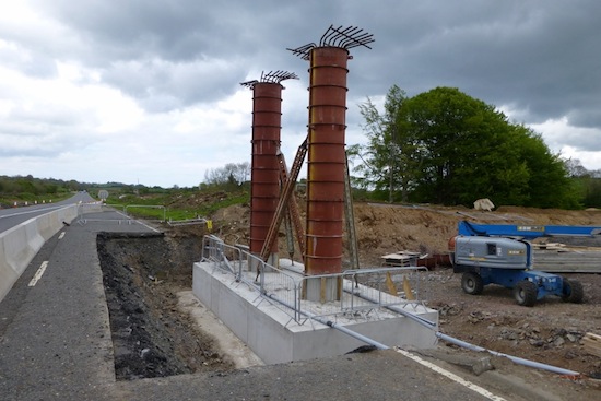
Pic 5: The bridge that will carry the A57 over
the future dual-carriageway near Ballynure now
appears to have its bridge deck and part of its
parapets on 19 Jan 2014. This will the first
bridge to open to traffic, after which the
existing A57 on the left will be removed to make
way for a major cutting. [Noel O'Rawe]
Pic 6: 19 Jan 2014. The view along Church Road
near Ballynure, which is currently closed, as
the abutments for the flyover that will carry
the A8 over it are built. This is the same
view before work began. The concrete ramp
on the left appears to be a temporary works
access route for construction machinery as it
crosses the Ballynure Water (behind the white
canvas barriers). [Noel O'Rawe]
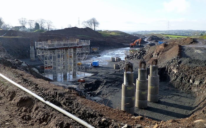
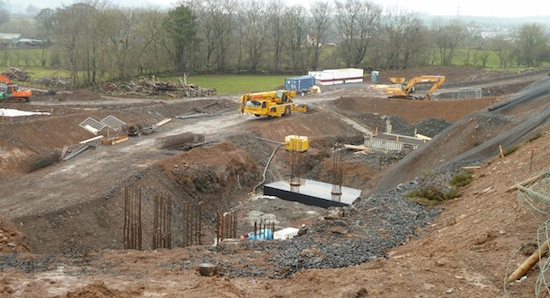
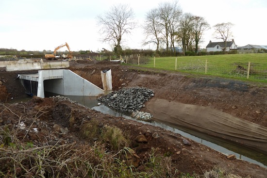
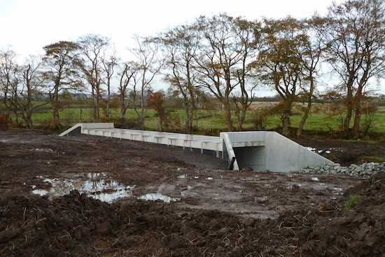
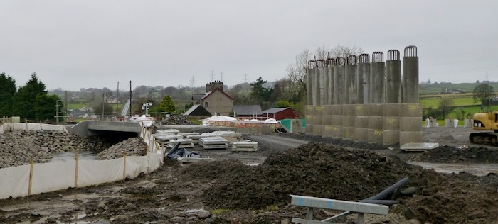
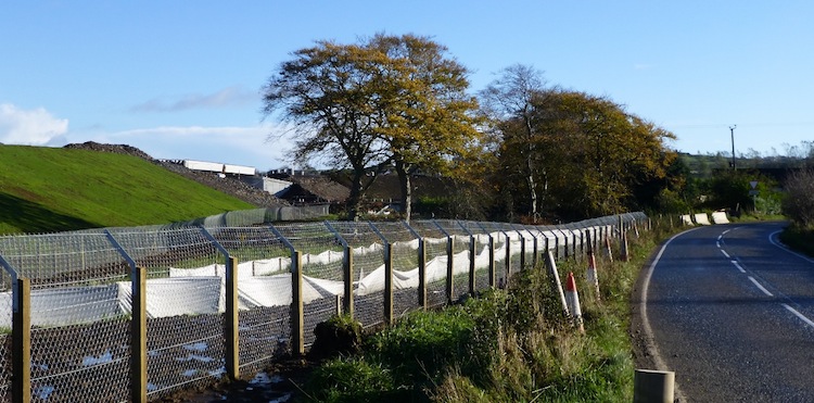
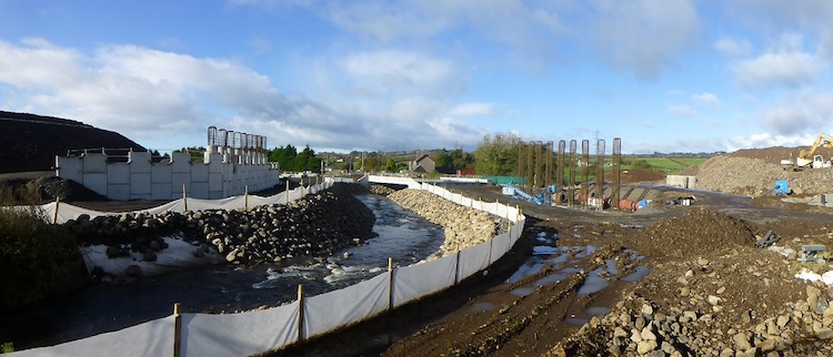
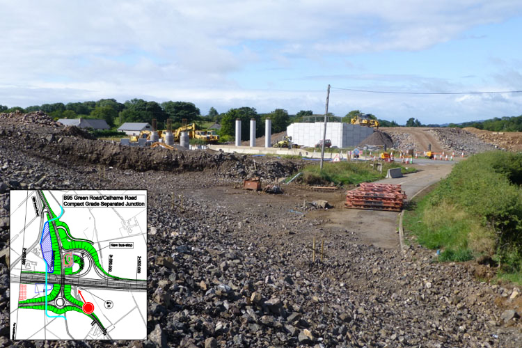
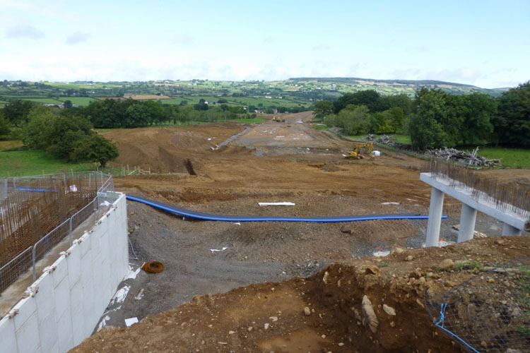
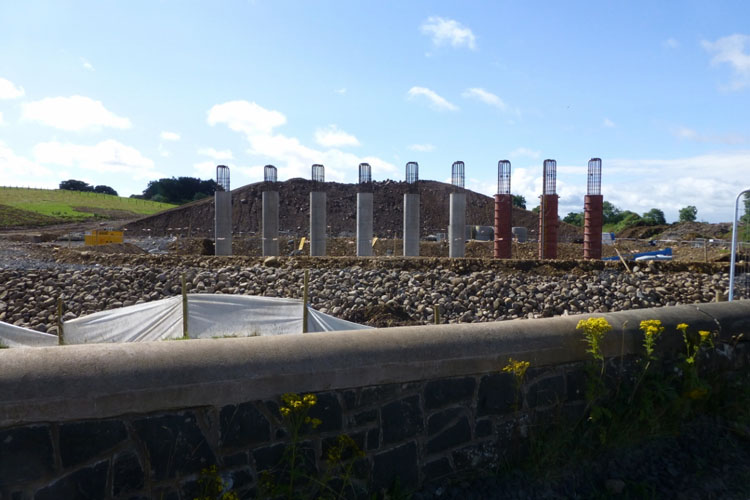
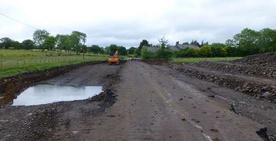
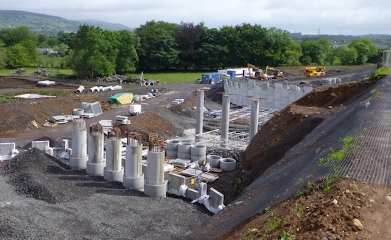
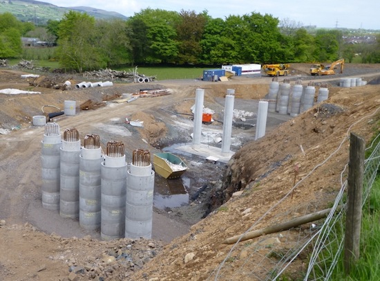
Pic 7: As the A8 Ballynure Bypass crests the
hill behind the village it descends into this
enormous cutting, here seen on 19 Jan 2014 from
Lismenary Road. The pillars for the bridge that
will carry the Lismenary Road are slowly taking
shape. [Noel O'Rawe]
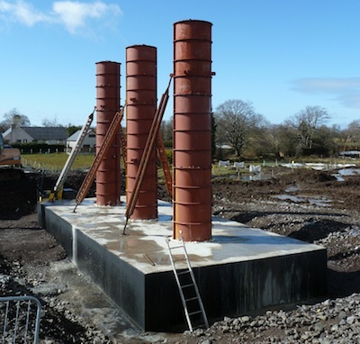
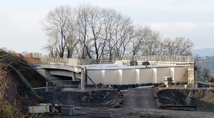
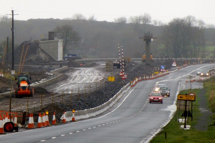
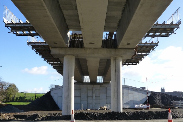
Pic 8: The Moss Road flyover sporting all its
bridge beams on 19 Jan 2014. Hurrah! You can see
how the future northbound carriageway on the
left is being built up to achieve the necessary
"vertical geometry", ie to smooth out the
undulations. [Noel O'Rawe]
Pic 9: This picture of Moss Road flyover was
taken on 22 Dec 2013, before the second beams
were lifted into place. It shows just how much
higher the future road surface will be compared
to the existing surface, perhaps 3 metres. It's
entirely possible that the existing road here
will be simply buried, providing an interesting
discovery for future archaeologists. [Noel
O'Rawe]
Pic 10: View south east along Moss Road on 19
Jan 2014, with the Moss Road flyover in the
distance. The part of Moss Road on the right
will become a cul-de-sac, accessed from the
little link over the culvert seen here, from the
new route of Moss Road, seen taking shape on the
left here. The approach ramps for the bridge are
also underway in the distance. Note the striking
red colour of the rock here - perhaps this
reflects the local geology, but I'm not a
geologist so can't say! [Noel O'Rawe]
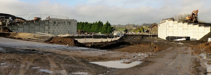
Pic 11: Between Moss Road and Deerpark Road an
existing cutting has been widened to accommodate
the new road. Here we see the future northbound
carriageway (left) sitting neatly beside the
existing A8 (right) on 19 Jan 2014. [Noel
O'Rawe]
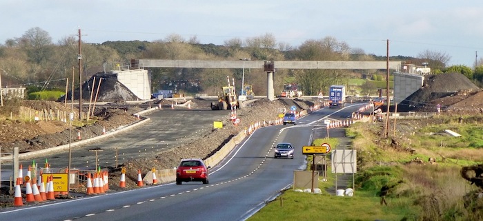
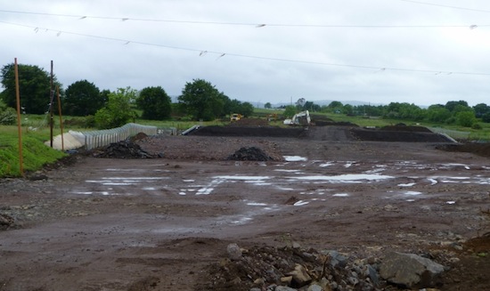
Pic 12: Looking north towards Deerpark Road
flyober (visible in the distance) on 19 Jan
2014. The existing A8 makes a sharp left turn
here that's too sharp for the high design
standards of the new road, so it swings off to
the right in order to take the turn more gently.
The bit of road taking shape here is the entire
dual-carriageway as it swings off to the right
to make this turn. It will then turn left
roughly where the tanker lorry is parked and
slot under the bridge. [Noel O'Rawe]
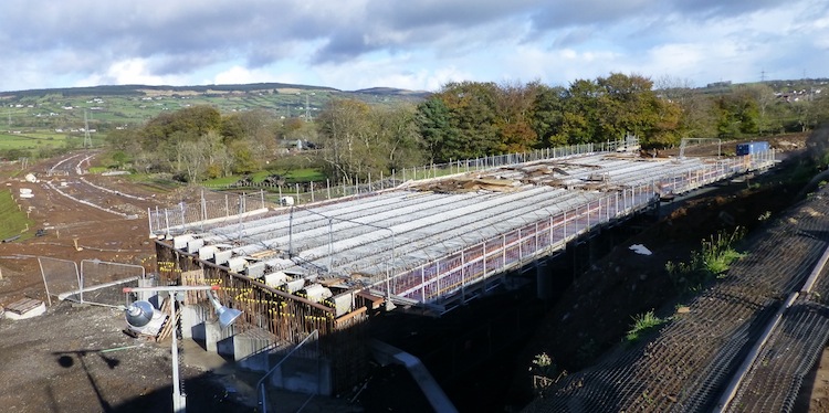
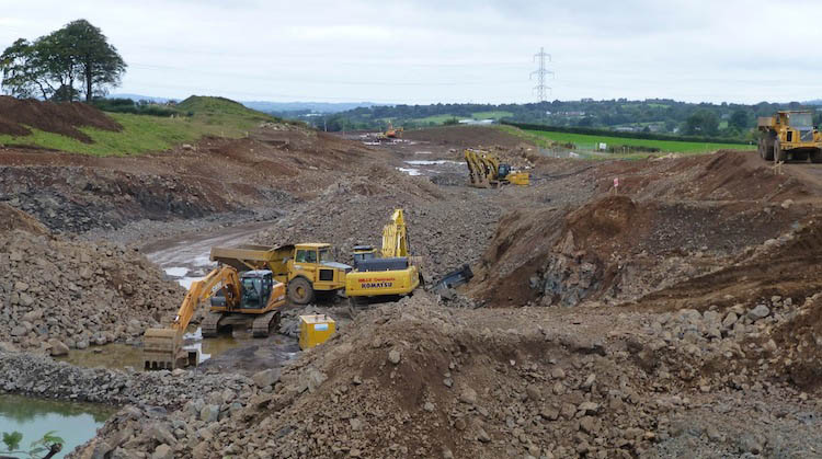
9 Dec 2013: The scheme is
now at approximately the half way point, with
completion due in Spring 2015. These 12 pictures
were all taken yesterday (8 Dec) by Noel O'Rawe
to whom we are indebted for braving the December
cold to get these snaps. As far as I can see, no
more bridge beams have been put in place,
although the Moss Road flyover looks as if it is
quite close to being ready for this. The bridge
deck at the A57 bridge is also nearing
completion and will presumably soon get a
parapet and then a road surface. Work in other
areas is continuing. The short stretch of road
that bypasses the settlement of Bruslee, from
Coleman's Corner roundabout to roughly Glen
Road, has now been mostly surfaced and
looks as if it will be ready to carry traffic
soon. It is possible that traffic will be
switched onto one carriageway of this part
(probably the future southbound carriageway)
before too long in order to complete the tie-in
to the existing road network. The pictures below
are arranged in order from south to north.
Because the site can be a bit of a desolate
wilderness, with mud everywhere, it can be hard
to make sense of some of the images. In these
cases I've included a snippet map to try to make
it clearer what we're looking at. If you want
see more design maps you can download
the full set of plans here [11MB]. Enjoy!
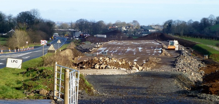
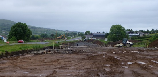
Pic 1: Looking north east from Coleman's Corner
roundabout on 8 Dec 2013, with the existing road
on the left and the new road that swings out
past Bruslee on the right. Work seems to be
underway to tie the two together. Same
view before work began. [Noel O'Rawe]
Pic 2: Moving a couple of dozen metres forward
to get a closer look at the stretch bypassing
Bruslee, we can see that the final road surface
is being laid here. Traffic may soon be diverted
onto this very advanced section. 8 Dec 2013
[Noel O'Rawe]
Pic 3: This is the point where the section
bypassing Bruslee rejoins the existing A8 (on
the right). We've turned round and are looking
back towards Belfast here. A new layby is
evident taking shape just ahead. Same
view before work began. 8 Dec 2013 [Noel
O'Rawe]
Pic 4: The view south west (towards Belfast)
from Calhame Road on 8 Dec 2013 showing progress
on the future northbound carriageway well
advanced on the right. In the distance is where
the road swings away round Bruslee, the location
shown in the Pic 3 above. Approximately the same
view before work began. [Noel O'Rawe]
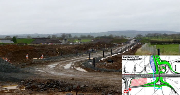
Pic 5: A view of the Green Road/Calhame Road
grade separated junction taking shape on 8 Dec
2013, with an inset map showing the location of
the camera as a red arrow. The road ahead is the
future link road that will connect Calhame Road
(where the photographer is standing) up onto the
flyover, which is visible ahead. Same
view before work began. [Noel O'Rawe]
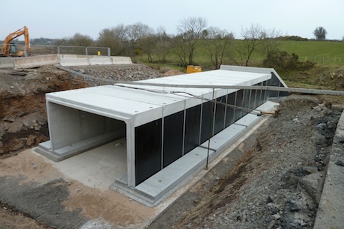
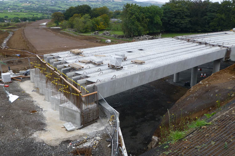
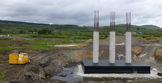
Pic 6: The bridge that will carry the A57
Templepatrick Road over the new dual-carriageway
had a complete bridge deck on 8 Dec 2013. Work
on the parapets must surely come next, along
with the approach embankments. Same
view before work began. [Noel O'Rawe]
Pic 7: At Church Road, on the Ballynure Bypass
stretch, work was continuing to build the
northern bridge pillars for the future flyover
on 8 Dec 2013. Church Road here still appears to
be shut, and will presumably remain so until the
bridge beams are in place. The small bridge
visible ahead is the new bridge that will carry
Church Road over the river. This
is the location of these structures. [Noel
O'Rawe]
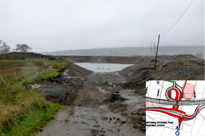
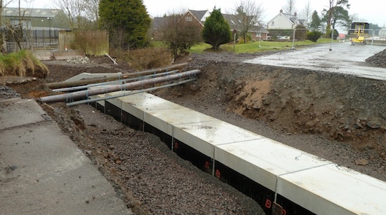
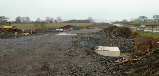
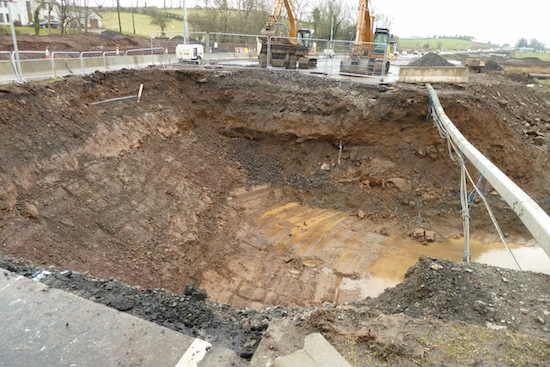
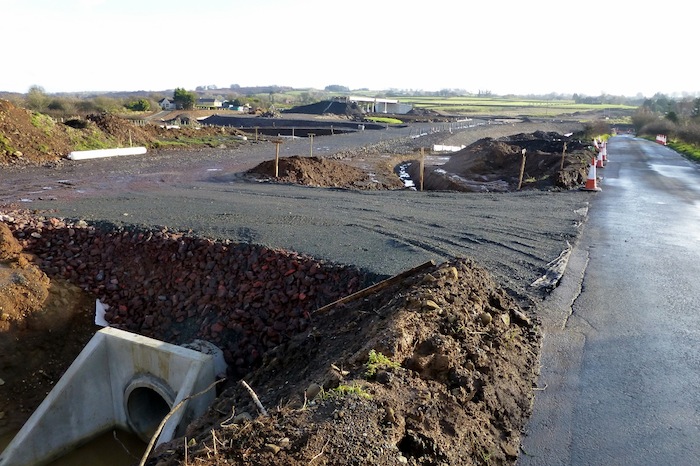
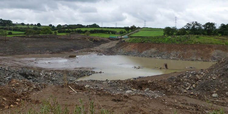
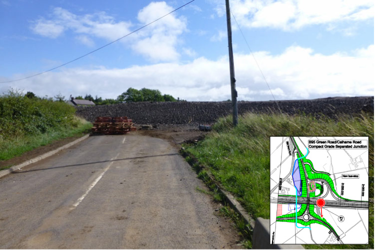
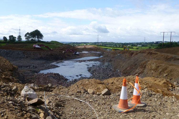
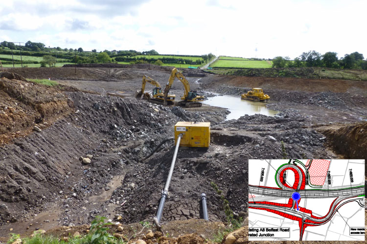
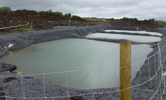
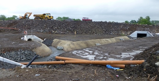
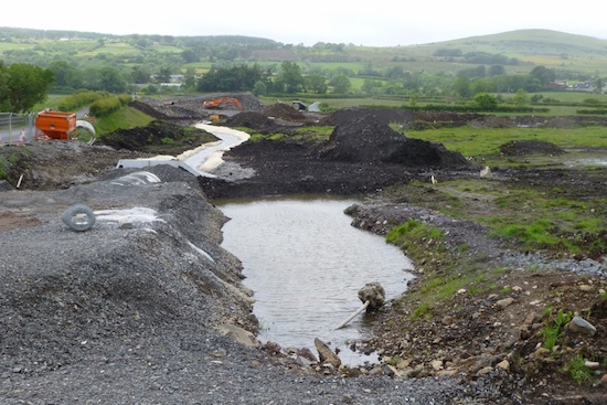
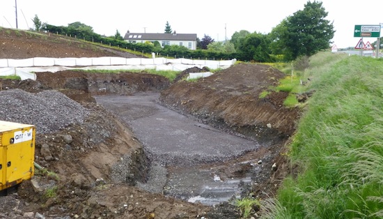
Pic 8: At Ballybracken Road, where the local
road network is being sunk below ground level to
facilitate an underpass, the enormous excavation
that was made in the summer was partly full of
water on 8 Dec 2013 with not much work evident.
The inset shows the location of the photographer
as a blue arrow. Same
view before work began. [Noel O'Rawe]
Pic 9: Moss Road flyover taking shape on 8 Dec
2013, in this view looking north east from Ballygowan
Road. This is likely to be the next bridge
to get its beams. Note how rock is being used to
fill in the undulating topography so that the
new road will be much smoother than the existing
one. [Noel O'Rawe]
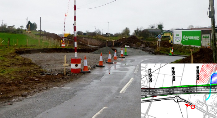
Pic 10: Ballygowan Road currently joins the
existing A8 (where the lorry is) at a
T-junction. It will be stopped up eventually, as
shown in the inset map. In this shot, taken on 8
Dec 2013, the new turning circle can be seen
taking shape as well as a new private access
road to provide alternative access to property
that will no longer be permitted to open
directly onto the A8. [Noel O'Rawe]
Pic 11: Another view of the Moss Road flyover,
this time taken from Moss Road (see inset map
for location) on 8 Dec 2013. It shows the future
route of the diverted Moss Road where the digger
is, with two roads running to the left. One is
for a private exit, and the second is the
approach road that will lead up onto the
flyover. Same
view before work began. [Noel O'Rawe]
Pic 12: An unusual perspective on the Deerpark
Road flyover, looking south east from Deerpark
Road itself on 8 Dec 2013. This bridge already
has its beams ans is now getting its road deck
on top. Same
view before work began. [Noel O'Rawe]
5 Nov 2013: This update
contains more photographs, this time taken on 3
November by Noel O'Rawe (thanks!). The scheme
continues to make good progress. According to
the contractor's own
web site, the summer saw a lot of soft
excavation work (eg removal of topsoil) which is
now complete in most areas, and stabilisation of
soft ground, especially at the future Green
Road/Calhame Road junction. The contractor is
attempting to re-use excavated rock on other
parts of the project. To date, the source of
much of the rock already used for embankments,
etc, has been the cutting south of the A57
Templepatrick Road near Ballynure. During the
winter the contractor will be extracting more
rock from the cutting that is needed in the
Ballynure Bypass stretch, in some cases by
blasting. This additional rock will also be used
to manufacture the road base. Three overbridges
now have their beams in place - the A57
Templepatrick Road bridge, and the flyovers at
Deerpark Road and Green Road/Calhame Road. On
the southernmost stretch the kerbs for the
actual carriageway are now going in, making this
section the most advanced on the scheme. The
pictures below are arranged in order from south
to north.
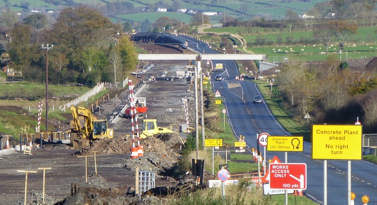
Pic 1: View north from Coleman's Corner on 3 Nov
2013. This is where the A8 swings east to bypass
the settlement of Bruslee. Work on the road
itself is now underway in the form of kerb
lines. [Noel O'Rawe]
Pic 2: Telephoto shot north along the existing
A8 on 3 Nov 2013, from near Glen Road and
looking towards the partially build flyover at
the future Green Road/Calhame Road grade
separated junction. Drainage is being installed
on the future northbound carriageway on the
left, while the old road remains in situ, for
now, on the right. [Noel O'Rawe]
Pic 3: View east along the existing line of
Green Road (right) and its future route up onto
the flyover (left). The road on the right will
be retained as a cul-de-sac for access to local
properties. The fencing surrounds a diverted
watercourse. Between the watercourse and the
flyover, but not obvious in this shot, is a
flood constriction pond, designed to prevent the
overloading of drainage channels during heavy
rain storms by storing water and releasing it
gradually. 3 Nov 2013. [Noel O'Rawe]
Pic 4: The view south along the A8 towards the
flyover for the future Green Road/Calhame Road
grade separated junction, which has recently had
its beams put into place. 3 Nov 2013. [Noel
O'Rawe]
Pic 5: Closeup of the 3 Nov 2013 flyover for the
future Green Road/Calhame Road grade separated
junction, which has recently had its beams put
into place. [Noel O'Rawe]
Pic 6: The flyover that will carry the A57
Templepatrick Road over the new dual-carriageway
continues to take shape with the road deck being
constructed as seen on 3 Nov 2013. Once
completed the A57, where the photographer is
standing, will be diverted onto it so that the
rest of the cutting can be excavated. [Noel
O'Rawe]
Pic 7: At Church Road, on the Ballynure Bypass
stretch, the Ballynure Water diversion is
complete, the new local bridge in place over it,
and the old stone bridge now demolished. Work is
now underway on the southern bridge abutment
(right) which, together with the one on the
left, will allow a flyover to take the new road
over the whole lot. 3 Nov 2013. [Noel O'Rawe]
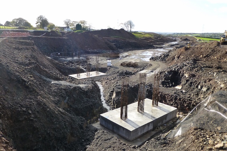
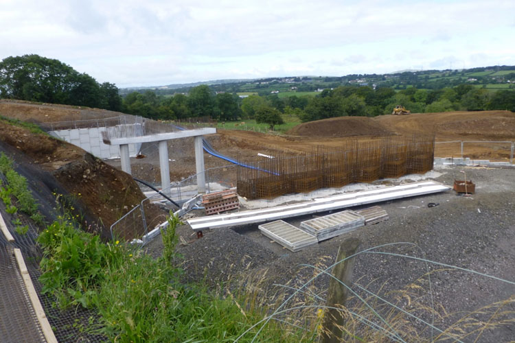
Pic 8: Further along the Ballynure Bypass
stretch the road enters a long cutting. This
cutting is crossed by Lismenary Road which will
be carried on a new flyover, the foundations of
which are seen here. The picture is taken from
the existing Lismenary Road which runs parallel
to the left of the shot. Work this coming winter
will focus on excavating the rest of this
enormous cutting. 3 Nov 2013. [Noel O'Rawe]
Pic 9: The view north east towards the flyover
for the future Moss Road grade separated
junction, which had yet to get its beams on 3
Nov 2013. The future road will be a couple of
metres higher than the existing road, hence the
huge pile of rock on the left where the future
northbound carriageway will be. This has been
piled literally on top of the tarmac of part of
the existing road, creating an interesting
artifact for future archaeologists! [Noel
O'Rawe]
Pic 10: The view south from the same location as
the previous shot at Moss Road, showing how the
new road will be built up to a higher level.
Eventually the existing road on the left will be
similarly built up. 3 Nov 2013. [Noel O'Rawe]
Pic 11: View north along the A8 towards the
Deerpark Road flyover on 3 Nov 2013. This will
eventually form part of another grade separated
junction. [Noel O'Rawe]
Pic 12: Closeup of the underside of the Deerpark
Road flyover on 3 Nov 2013, showing that the
bridge deck is taking shape above the enormous
beams. The platforms on the left and right are
presumably temporary structures for workers.
[Noel O'Rawe]
24 Sep 2013: This update is
to bring you another set of images, taken on
Sunday 22 September by Noel O'Rawe (with thanks
as always). The most obvious change from the
perspective of the observer is the addition of
the bridge beams at the A57 bridge near
Ballynure. It seems likely that beams will be
added to the Deerpark Road bridge within the
next week as well, which would make two. From
the contractor's point of view, the past month
seems to have been a combination of earthworks,
especially the enormous cutting on the Ballynure
Bypass stretch, but also embankments and bridge
approaches. Work has also been progressing on
structures, with more work on various bridges
and culverts – the Larne River has now been
diverted into its new culvert. Work has also
advanced on the road base in some locations,
with drains now in place on some stretches,
along both what will be the central reservation
and the sides of the future road. The photos are
arranged in order starting at the Belfast end of
the scheme and heading towards Larne.

Pic 1: The view north east from the Coleman's
Corner roundabout at the south end of the
scheme, showing the foundations of the new road
taking shape, with drains going in. This part of
the route is offline to bypass the settlement of
Bruslee. 22 Sep 2013 [Noel O'Rawe]
Pic 2: The view north east from Lisglass Road on
22 Sep 2013 along what will be the central
reservation, again showing drains in place. This
is the same view before work began. [Noel
O'Rawe]
Pic 3: Part of the embankment for the Green
Road/Calhame Road grade separated junction
looking well advanced on 22 Sep 2013, here seen
looking south east from Green Road with the
existing A8 in the right distance. [Noel O'Rawe]
Pic 4: The flyover component of the Green
Road/Calhame Road grade separated junction, seen
looking north east from Calhame Road on 22 Sep
2013 [Noel O'Rawe]
Pic 5: The A57 bridge taking shape with the
bridge beams in place on 22 Sep 2013. They
appear to be hollow (metal?) beams. In the
background the formation of the Ballynure Bypass
stretch is looking very neat with a diverted
watercourse on the left. [Noel O'Rawe]
Pic 6: At Church Road, on the Ballynure Bypass
stretch, the new bridge that carries Church Road
over the Ballynure Water is completed and in use
with the river diverted into it. The old bridge,
on the right, will presumably the removed. The
piers are for the flyover that will carry the
future A8 over the whole lot on a flyover. Seen
on 22 Sep 2013 [Noel O'Rawe]
Pic 7: The view south west from Lismenary Road
on 22 Sep 2013, where the vast cutting for this
part of the Ballynure Bypass is still being
excavated. This is a zoomed-in view of the same
area shown in Pic 10 in the previous update.
[Noel O'Rawe]
Pic 8: View north from the existing A8 near
Ballybracken Road, just north of Ballynure. This
is the point where the Ballynure Bypass stretch
will rejoin the existing A8. The cutting on the
right is for a road that will carry local
traffic into Ballynure (behind the camera) after
the new A8 is operational. 22 Sep 2013 [Noel
O'Rawe]
Pic 9: Another view of the completed cutting
that will carry a range of local roads below
ground level around the Ballybracken Road grade
separated junction, seen on 22 Sep 2013.
Excavation work appears to be completed although
the hole has a lot of sitting water in it due to
recent rainfall. [Noel O'Rawe]
Pic 10: The future flyover for the Deerpark Road
grade separated junction, close to the north end
of the scheme, on 22 Sep 2013. This junction is
likely to be the second one to get its bridge
beams in the near future. [Noel O'Rawe]
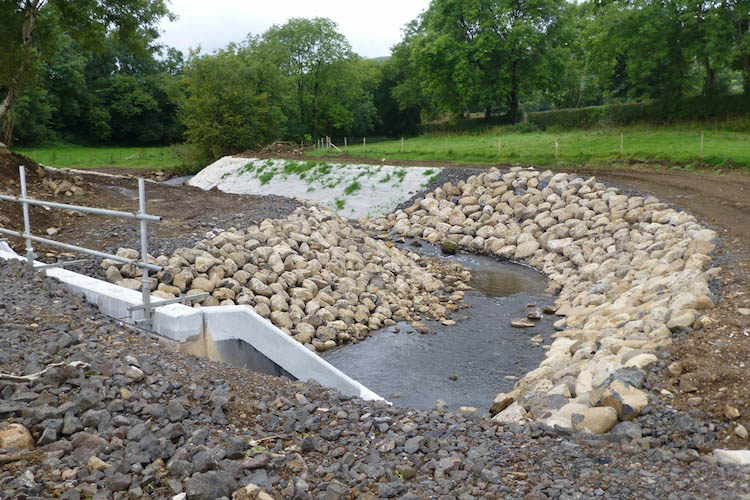
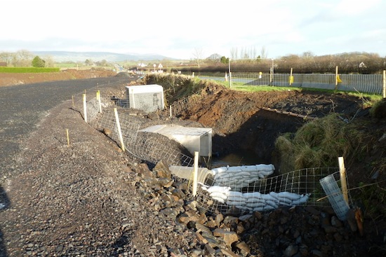
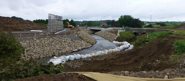
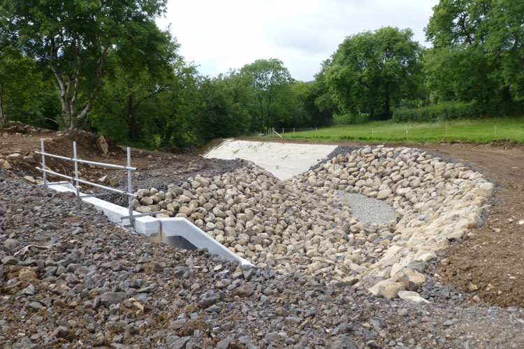
Pic 11: The Larne River finally diverted into
its carefully crafted new culvert on 22 Sep
2013. Compare to the view last month (Pic 13 in
the 21 August update below) when the culvert was
still under construction. The grass shows that
even now nature has begun to reclaim this
territory. [Noel O'Rawe]
4 Sep 2013: A very quick
update to make you aware that the contractor,
Lagan Ferrovial Costain, have launched a web
site dedicated to the scheme at http://a8lfc.com.
The site aims to provide updates on the progress
of works, recent news, information on the
contractors and also some photographs. I would
draw your attention in particular to the downloadable
scheme newsletter which dates from last
Spring and is a very interesting read. The main
page of the site contains some nice photographs
of the works underway. These have the advantage
of having been taken on the site itself, hence
showing scenes inaccessible to the public,
although they are of limited use since they're
not dated or captioned, so we don't know what
they are showing or when they were taken.
21 Aug 2013: The project
has now been underway for just over a year, with
just under two years yet to go. Until the summer
most of the work seemed to focus on vegetation
clearance, building low-level structures such as
culverts and constructing bridge piers. In more
recent months, however, many of these have been
completed and instead there has been an
increased focus on earthworks with both
embankments and cuttings taking shape on a very
impressive scale. One of the largest cuttings on
the whole project is the offline section
bypassing Ballynure, which is now well underway.
The selection of pictures below were provided by
our own Noel O'Rawe (thank you) who visited the
site at the weekend and illustrates the progress
that has been made. The past three months has
seen exceptionally good weather so the
contractor will likely have been able to take
full advantage of the dry days and late sunshine
to move things along. The photos are arranged in
order starting at the Belfast end of the scheme
and heading towards Larne. (Last month I
increased the size of the pages on the site, so
these pictures are at a new, larger size -
enjoy).

Pic 1: The view along the A8 from near Glen Road
on 17 Aug 2013, showing the future northbound
carriageway taking shape while the existing road
runs on the right. On the left the drains are
being installed. This
is a similar view before work began. [Noel
O'Rawe]
Pic 2: The view looking south at the site of the
future Green Road/Calhame Road grade separated
junction on 17 Aug 2013. The inset map shows
where the picture was taken. You can see that
the large, curved embankment taking shape ahead
is the future northbound offslip and onslip,
while the bridge piers are visible on the left.
[Noel O'Rawe]
Pic 3: In the previous update (see below) work
on the embankment to carry Legaloy Road up onto
the new bridge had just begun, and as of 17 Aug
2013 seems to be well advanced. The inset map
shows where the picture was taken. This little
stub of road is now redundant and will
presumably be removed and grassed over. [Noel
O'Rawe]
Pic 4: A final picture at the Green Road/Calhame
Road grade separated junction, taken from the
location marked on the inset map on 17 Aug 2013.
The piers for the future flyover are taking
shape ahead. Taken from the embankment that will
carry Calhame Road up onto the bridge. [Noel
O'Rawe]
Pic 5: The future bridge that will carry the A57
over the new dual-carriageway still hadn't got
its beams in place on 17 Aug 2013, but is
nevertheless one of the most well-advanced
bridges on the scheme. Once it has been
finished, the A57 (which currently runs parallel
to it, to the left here) will be diverted onto
the bridge and a huge cutting excavated on the
left. [Noel O'Rawe]
Pic 6: The view north from the A57 on 17 Aug
2013, with the Balllynure bypass section of the
road progressing very well ahead. This is
the same view before work began. Work on
the huge cutting behind the camera has yet to
get this advanced. [Noel O'Rawe]
Pic 7: At Church Road there is to be a double
bridge! Church Road crosses over the Ballynure
Water river, while the new dual-carriageway will
itself be bridged over this bridge on a flyover.
The existing
bridge is a narrow stone construction and
is being replaced by this more modern edifice,
here seen on 17 Aug 2013, which is a few metres
west of the existing bridge. This is
the same view before work began. [Noel
O'Rawe]
Pic 8: Remaining at Church Road, where the
previous picture was taken, these are the piers
for the much larger flyover that will carry the
future A8 over both Church Road and its new
river bridge. This is
a similar view before work began (the
existing bridge parapet has been repaired in the
interim). 17 Aug 2013. [Noel O'Rawe]
Pic 9: Still at Church Road, but turning around
180°, this is the embankment for the future A8
taking shape on the north side, as seen on 17
Aug 2013. This is
the same view before work began. The
existing bridge that the photographer is
standing on will presumably be removed and the
site buried under this embankment, since the
river is being shifted west by a few metres.
[Noel O'Rawe]
Pic 10: By the time the Ballynure bypass stretch
of the new road reaches Lismenary Road it will
have descended into a long cutting, one of the
largest on the whole scheme. This view looking
south west from Lismenary Road on 17 Aug 2013
shows work well underway to excavate this
enormous feature. The scheme has been specially
designed so that the majority of material
removed from places like this can be re-used for
embankments elsewhere on the scheme, thus
minimising waste. This is
the same view before work began. [Noel
O'Rawe]
Pic 11: Ballybracken Road, just north of
Ballynure, is where the Ballynure bypass section
of the scheme rejoins the line of the existing
A8. The souhbound offslip, northound onslip and
a local road will all be accommodated in a
network of cuttings (in red on the map). This
view on 17 Aug 2013 shows the work underway,
taken from the existing A8 at what will
eventually be an overbridge. The inset map shows
the location of the shot as a blue dot,
indicating what the view encompasses. [Noel
O'Rawe]
Pic 12: Looking south west from close to Moss
Road on 17 Aug 2013, this is another section
where the future northbound carriageway is
taking shape beside the existing A8. This is
the same view before work began. [Noel
O'Rawe]
Pic 13: Our final shot is of the almost
completed Larne River diversion, which has yet
to have the river diverted into it, as seen on
17 Aug 2013. The attention to detail here is is
very interesting - this is not simply a concrete
channel, but a well-planned piece of
eco-engineering designed to encourage the
formation of a natural river environment once
again. This is
the same view before work began. [Noel
O'Rawe]
2 Jul 2013: Another update,
this time taken on 23rd June by Noel O'Rawe (to
whom we are indebted)! We can see that progress
continues to be excellent over the past month.
The pictures below are arranged in sequential
order starting at the Belfast end of the scheme
and heading towards Larne.
Pic 1: The view south-west from Lisglass Road,
ie towards Corr's Corner. The road is being
built offline here, and with the land now
cleared the stone road base now seems to be
going in. This is the same
view before work began. 23 June 2013 [Noel
O'Rawe]
Pic 2: The view north along the A8 at the site
of the future Green Road/Calhame Road grade
separated junction. When compared to how the
site looked two
months ago, you can see that the western
bridge abutment is now in place, as are the
pillars that will be in the central reservation.
Work on the eastern abutment seems to be
underway on the right. 23 June 2013 [Noel
O'Rawe]
Pic 3: A brand new flood constriction pond
taking shape near Green Road. When finished this
will collect runoff water from flood events so
as not to overwhelm local watercourses. 23 June
2013 [Noel O'Rawe]
Pic 4: The view east from the existing A8 at the
site of the future Green Road/Calhame Road grade
separated junction. Two diverted watercourses
are taking shape, while the gravel beyond will
be the approach embankment to carry the road
onto the flyover. This is the same
view before work began. 23 June 2013 [Noel
O'Rawe]
Pic 5: The "old" Legaloy Road being removed so
that it can be diverted up onto an embankment
(taking shape to the right) to lead it up onto
the flyover. This bit of the road will be buried
under the embankment when completed. This is the
same
view before work began. 23 June 2013 [Noel
O'Rawe]
Pic 6: The pillars for the future flyover that
will carry the A57 Templepatrick Road over the
new dual-carriageway near Ballynure are
completed and the abutment walls have been
added, and the space behind them is now being
in-filled. Presumably work will soon focus on
putting the bridge beams in place so that the
existing A57 (where the photographer is
standing) can be diverted onto it to allow the
huge cutting to be excavated for the future
dual-carriageway. 23 June 2013 [Noel O'Rawe]
Pic 7: The view north-east from Ballybracken
Road, just north of Ballynure. There will be a
southbound offslip into Ballynure here, which
will be built in a cutting to the right of this
shot. The land just ahead is being cleared for
the future dual-carriageway which swings
slightly off the line of the existing A8 for a
short distance here to achieve the necessary
geometry. This is the same
view before work began. 23 June 2013 [Noel
O'Rawe]
Pic 8: Looking north west from the existing A8
at Moss Road (visible on the left) a small river
is being carefully realigned prior to work
beginning on a series of embankments for the
grade separated junction, which will eventually
bury all the land visible on the right here.
This is the same
view before work began. 23 June 2013 [Noel
O'Rawe]
Pic 9: At the same junction at Moss Road, these
are the recently constructed pillars for the
eastern end of the future Moss Road flyover.
This is the same
view before work began. 23 June 2013 [Noel
O'Rawe]
Pic 10: At Deerpark Road there will be another
grade separated junction. This is the view
south-east from Deerpark Road along what will be
the new link road connecting it to the bridge,
the embankments of which are taking shape ahead.
This is the same
view before work began. 23 June 2013 [Noel
O'Rawe]
Pic 11: The view south near Park Road where the
substantial culvert that will carry the diverted
Larne River is progressing well. The eastern bit
(on the left) is finished and work is well
underway on the western bit. Once completed the
Larne River, which currently runs about 50
metres ahead will be diverted through here. 23
June 2013 [Noel O'Rawe]
Pic 12: Finally, at the extreme north end of the
scheme at Ballyrickard, the foundations for the
future terminating roundabout are taking shape
beside the existing road. The white screens are
around a diverted watercourse. This is the view
south. This is the same
view before work began. 23 June 2013 [Noel
O'Rawe]
27 May 2013: More photos, all taken on
26th May by Noel O'Rawe. With work of some form
having been underway now for 10 months, progress
seems to be excellent as you can see, and some
of the earthworks are now pretty impressive in
their scale. The pictures are sequential
starting at the Belfast end of the scheme and
heading towards Larne.

1. View north-east from Lisglass Road, 26 May
2013. At this point the dual-carriageway is
being built off-line to bypass the settlement of
Bruslee. Here the road base is taking shape. This
is the same view before work began, and this
is the same view in the early stages of
work on 4 Nov 2012. Compare also to the same
view in November last year. [Noel O'Rawe]

2. View east from the A8 from opposite Green
Road, 26 May 2013. At this point there will be a
huge embankment for the Green Road/Calhame Road
grade separated junction, and beside the
embankment is to be a flood contriction pond,
designed to store floodwater and release it into
local watercourses in a controlled manner. I'm
not clear on what this huge water-filled hole is
for, however, as its location doesn't seem to
coincide with any of these structures. Perhaps
it is being used as a source of fill for use
elsewhere. This
is the same view before work began. [Noel
O'Rawe]
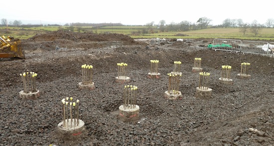
3. The pillars for the future flyover that will
carry the A57 Templepatrick Road over the new
dual-carriageway near Ballynure nearing
completion, 26 May 2013. The photographer is
standing on the existing A57, which will then be
removed and a huge cutting excavated to make way
for the new road. The bank here is extremely
steep, so a temporary concrete barrier has been
installed on the existing A57 to prevent
vehicles plunging off this precipice. This
is the same view before work began. The
progress can be seen by comparing how it looked
two
months ago. [Noel O'Rawe]
4. At Ballygowan Road, the new dual-carriageway
is being constructed by widening the existing
road, here seen on 26 May 2013. This is the view
north, towards Larne with the current road on
the right, which will later be rebuilt to become
the southbound carriageway, while the northbound
carriageway will be built on the left. This
is the same view before work began. [Noel
O'Rawe]
5. At Moss Road there will be a new
grade-separated junction facilitated by a
flyover, of which this is the western end, 26
May 2013. The land beyond will later be buried
by the approach embankment, so all the
vegetation has been removed. This
is the same view before work began. [Noel
O'Rawe]
6. Similarly, there will be a large
grade-separated junction at Deerpark Road, with
another flyover. These pillars, seen looking
north towards Larne on 26 May 2013, will
eventually be in the central reservation of the
future dual-carriageway. This
is the same view before work began. [Noel
O'Rawe]
7. Another view looking north towards the site
of the future Deerpark Road flyover shows the
western, central and eastern bridge pillars, 26
May 2013. The one on the left is now getting the
cladding which will support the embankment that
will be created behind it. The existing A8 runs
on the left, but the photographer is standing on
what will be the southbound carriageway. [Noel
O'Rawe]
8. Finally, work continues at Park Road to
divert the Larne River. This view looking south
on 26 May 2013 shows a new chicane being created
on the left, over the bit of the culvert that
has now been completed, presumably to allow the
second half to be constructed. The view is
almost unrecognisable from what it was before
work began. [Noel O'Rawe]
|