|
|
Status
|
Construction scheme
(under construction) |
|
Contractor
|
BAM
|
|
Where
|
To
construct a new bridge connecting the A2
near Warrenpoint, county Down to the
R173 near Omeath, county Louth at Narrow
Water |
|
Total
Length
|
0.5 km / 0.2 miles
|
|
Dates
|
January 2007 -
Cross-border funding proposed from Irish
NDP
May 2008 -
Preliminary route options published
Oct 2008 - Final
route and preliminary bridge design
published
Apr 2011 - Ground
investigation works begin at site
Jul 2011 - Irish
government decides not to proceed with
scheme
Dec 2011 - Emerges that Louth CoCo may
proceed by themselves
Mar 2012 - Louth CoCo applies for
planning permission and issues CPO
24 Oct 2012 - Planning permission
approved in NI and RoI
24 Oct 2012 - European funding secured
to proceed
28 May 2013 -
Northern Ireland Dept of Finance
approves NI contribution
24 Jun 2013 (or after) - Contractor to
be appointed
9 July 2013 - Louth
Co Co suspend project due to escalating
costs
15 Nov 2013 - EU
withdraws funding due to Louth Co Co
being unable to secure sufficient
funding
Late Jul/Early Aug 2013 - Work
was to have begun, before
scheme suspended
Nov 2015 - NI and RoI
governments agree to prepare a report on
options for this scheme
Jun 2016 - Expected completion of
aforementioned report (as of Nov 2015)
Sep 2020 - DFI Minister Nichola Mallon
indicates her strong support for the
scheme
5 Sep 2022 - Construction tender
released by Louth County Council
20 Feb 2024 - Scheme given funding by
Irish government
24 May 2024 - Work
began
Late 2027 -
Anticipated completion (as of Nov 2024)
2028 - Due to be opened
|
|
Cost
|
€60m for construction
as of 2022
(€26-40m for construction as of 2013 –
higher than anticipated)
Was to have been £14m from EU, £2.7m
from N. Ireland, £0.8m from Louth CoCo
(as of May 2013)
changed from €18m (£14.5m) as of Oct
2012
changed from €14m (£11.1m) as of
2008
|
|
Maps/Photos
|
See below |
|
See
Also
|
General area
map - Google
Louth
County Council environmental statement
on scheme [PDF]
A2
Newry to Warrenpoint on this site
Video
flythrough of bridge - YouTube
|
Click here to jump
straight down to updates for this scheme.
This project is to build
a bridge across the top of Carlingford Lough
where it meets the Newry River. The bridge will
cross the narrowest point, at Narrow Water
Castle, which is about a mile north west of
Warrenpoint connecting the A2 Newry to
Warrenpoint dual-carriageway to the R173 in
county Louth close to Omeath. The bridge will be
unusual in that it will cross the international
border.
The Irish National Development Plan, launched
in January 2007, set aside a large sum of money
for projects in Northern Ireland and on
cross-border schemes and on 25 January 2007, the
BBC
quoted SDLP's PJ Bradley as saying that
the Irish government had assured him that they
would contribute €14m to the scheme. Despite
this, the Irish government announced in July
2011 that they would not be progressing the
plan. It was then progressed independently by
Louth County Council, who secured EU funding for
the project. All went well until July 2013 when
the project was suspended due to escalating
costs and the EU withdrew their funding in
November 2013, effectively halting the project
for a second time. After a further decade, the
scheme was then resurrected with Irish
government funding in 2024 and work finally got
underway in May 2024.
Originally three routes were proposed, but the
"orange" route was selected (see map below). The
proposed design for the bridge was then
released. This design is a cable-stayed bridge,
with the main support on the southern side, and
a smaller moveable section on the north side
which will be able to move to let ships through.
The whole bridge will have a length of 280
metres, with two towers of 100 metres and 30
metres in height.
Maps and Images
Artist's impression of the new
bridge, released to the public Oct 2008. [via Irish
Independent]
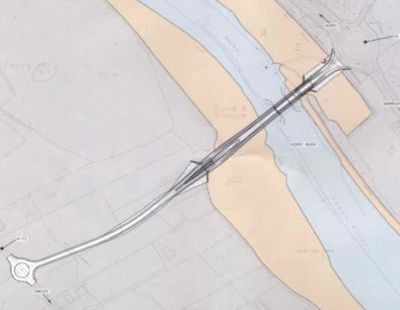
Plan view of the new bridge, as
of Oct 2008, showing the channel that boats will
use to get under the bridge. [Released to the
public Oct 2008]
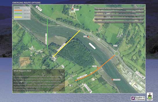
Route
options as presented to the public in May 2008
(NI to top right, RoI to bottom left).
The planners have since settled on the orange
route.
Progress
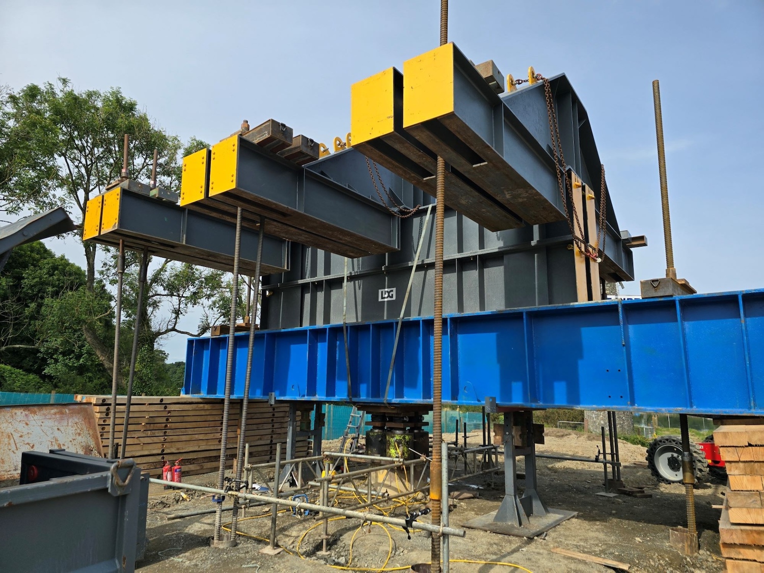
24 Apr 2026: This is a brief update to
share a link
to photos of the main bridge span being
constructed in Belgium. The photos have been
shared by Aelterman, the company making the
steelwork. With thanks to Cormac Duffin for
letting me know about this.
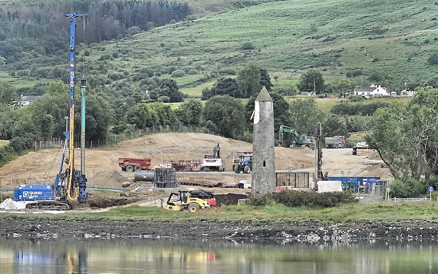
10 Apr 2026: Not a huge amount has
changed on site since the last update, though
work is moving at pace in Belgium where the
longer span is nearing completion, before being
floated to the site in June. The photo below was
taken by Joseph Donnelly (thank you) about three
weeks ago and shows the site as it was then,
with the southern (Louth) abutment largely
finished, and the northern abutment progressing
well. The northern abutment features a deep
hole, probably to house the machinery for the
lifting section, which will be on the Co Down
side. A couple of other useful links are to this aerial movie
taken by Gerald McGivern on 28 February, and this
article about the scheme that appeared in
New Civil Engineer at the end of
February.
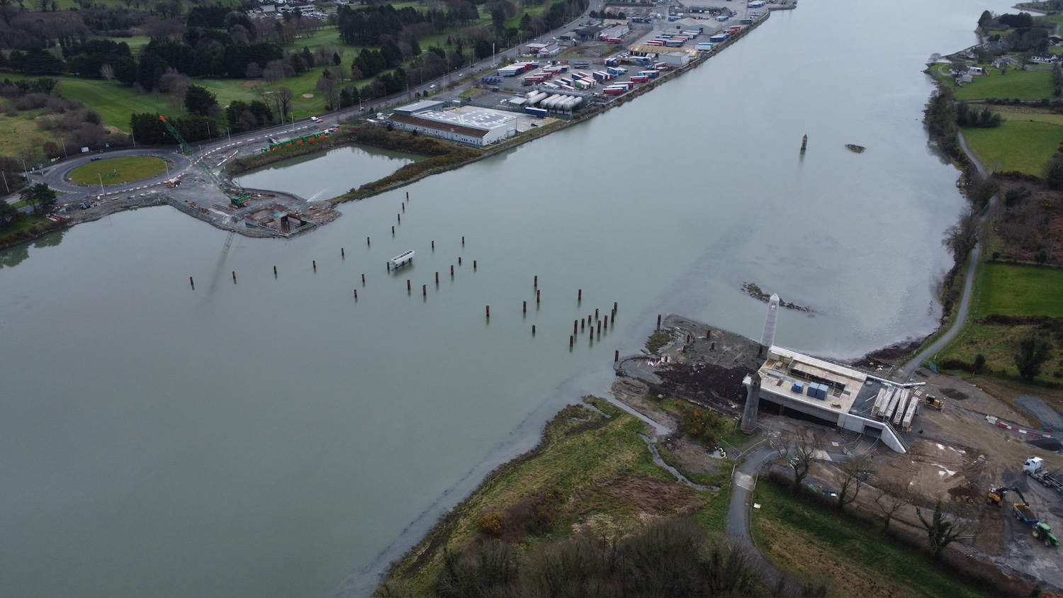
The site on 18 March 2026 with north and Co Down
on the left and Co Louth on the right. Joseph
Donnelly.
4 Mar 2026: This social
media post by Newry.LN from about two
weeks ago shows some more photos of the scheme
as it is now. The text also confirms that "the
bridge is currently being fabricated in Ghent,
Belgium, where steel sections are already
undergoing the painting process. The structure
is expected to arrive on-site during the
summer months, necessitating the temporary
closure [of the Carlingford Lough greenway] to
ensure safety and logistics are managed during
the installation". An article in New Civil
Engineer magazine last month stated that the
longer span, the one referenced above, will be
completed in May 2026 and arrive on site by
barge in June 2026. One end will be supported on
temporary piers in the river until the
supporting cables are completed. The other end
will be supported on the abutment on the Louth
side which has been completed for a few months
now. The shorter, lifting section (known as the
basicule) is also being built in Ghent and will
be completed in December 2026 and will arrive on
site in March 2027. The bridge is due to be
completed in October 2027, which is now 19
months away. That means we're now past the half
way mark! With thanks to David Anderson and
Patrick McGivern for information.
27 Jan 2026: Work on the bridge has
resumed after the Christmas break, though there
are no major changes from the point of view of
observers. Joseph Donnelly shared a photo
(below) showing the southern (Louth) abutment
looking complete, with the greenway now passing
through the tunnel beside it. The next big
milestone will be the arrival of the fixed
portion of the bridge, and the taller of the two
supporting masts, which will go on the south
side. The bridge will arrive by barge in three
sections, and will probably be supported
temporarily on the piles out in the channel. On
25 January Ann Bruen walked out at low water to
these piles, and you can see her footage about
30 seconds into this
video. Once the mast is in place, cables
will be connected between the mast and the deck,
at which point the supports can be removed.

The southern (Louth) abutment seen on 30 Dec
2025, with the Newry River to the right. The
larger of the two pylons will be positioned on
top of the right hand part of the grey
structure. Straight ahead is the tunnel carrying
the Greenway under it. [Joseph Donnelly]
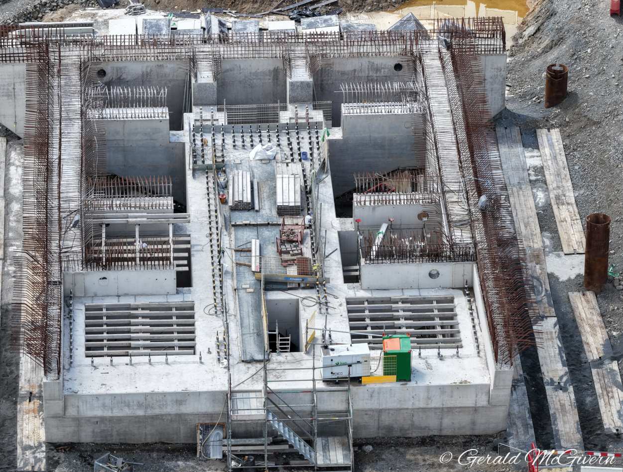
10 Dec 2025: Gerald McGivern has put up
a wonderful set
of photos on Facebook, taken two days ago
on 8 December. The photos focus on the northern
(Co Down) bridge abutment which will contain the
machinery for moving the basicule (the lifting
section of the bridge). The abutment itself is
now a little above ground level, but with a
large hollow inside for the plant room. I could
not help but share directly here one photo of
Gerard's, showing the entire bridge from the Co
Louth side. It is a lovely image as it shows the
Warrenpoint roundabout in the foreground, the
northern abutment, the temporary support in the
river, the southern abutment and the southern
approach road with the control room beside it.
We are expecting the first prefabricated bridge
sections to arrive by barge in the spring of
2026 which will really transform this view. With
thanks to Gerald McGivern.

Narrow Water bridge seen looking south from
Warrenpoint on 8 Dec 2025.
24 Nov 2025: Bridge Construction
Construction, one of the subcontractors on the
scheme, put up an interesting update
on Facebook last week. The update
concerned the 'plant room' where the motor for
lifting the bridge will the located (the
basicule is the section of the bridge that
moves) on the Down side of the bridge. The plant
room is located inside the northern bridge
abutment, and now has a solid floor. Equipment
will eventually need to be installed here, but
we're probably not yet close to the point where
that will happen. The next phase will be to
build the walls of the plant room and the
surrounding abutment. The basicule itself will
probably come pre-fabricated and then be craned
into position. In other news, the scheme now has
a web site – https://www.narrowwaterbridge.com
With thanks to those who let me know about
various events. We're now about a year and a
half into the project, with two years to run.
8 Sep 2025: Two weeks ago visitors to
the site may have done a double-take to see a
second navigation tower has suddenly
appeared beside the new bridge, on the Louth
side. The existing stone tower is a navigation
beacon dating from the 1880s. The new bridge
tower will obscure the view of the beacon from
the south-east so a second light was needed.
Fair play to the designers who could have just
built a modern steel structure, but have instead
opted to commission a concrete replica of the
existing tower (by
FP McCann) which was craned into place on
23 August. Right now it's very white, but fear
not as with our climate it will turn a much
duller colour within a few years and blend in
well. Other than that, work has continued over
the past three weeks. Gerald McGivern has shared
another
new video taken in late August. The video
starts on the county Down side and you can see
excavation work underway for the basicule (hinge
point) for the lifting section, a temporary
support in the centre of the river and then the
County Louth abutment, which is now approaching
deck level. Behind this abutment you can see the
completed box structure for the Greenway. I'd
expect to see the Greenway diverted through this
in the next few months to allow the approach
road embankment to be completed. Once that's
done, heavy equipment can get directly to the
abutment to start work on the main pylon and
bridge deck. We're expecting the deck to start
being fitted, by barge, around Easter next year.
15 Aug 2025: I don't have any recent
photos of this scheme, but Gerald McGivern put
up a video taken about three weeks ago on
the Louth side of the bridge. It showed a
concrete pour underway on the southern bridge
abutment, which is now at a height of several
metres above ground level. It also shows that
the future control building seems to be
externally completed. We are now 15 months into
the scheme, and about 27 months still to go, so
in time terms we're about a third of the way
through the project.
21 Jul 2025: Just a quick update to
share a link to a news
story on RTÉ which includes an interview
with the contractor. The story was published
over a month ago, but I forgot to include it in
the last update. With thanks to Pat McGivern for
letting me know about it. The story confirms
that work is on schedule and gives some useful
interim dates:
- The fixed bridge abutments were due to be
completed by the end of June 2025.
- The basicule abutment (basically, the hinge
for the lifting section) is underway and will
be completed around Sep/Oct 2025.
- The fixed bridge spans are being built in
Belgium and will float up the river in three
sections and will then be put in place over a
matter of months, starting at the end of the
first quarter of 2026.
- The opening section of the bridge (which is
on the County Down side) will arrive at
Warrenpoint port in March 2027 and will then
be driven the short distance to the site by
road.
- Once the bridge spans are in place the
temporary piles that have been installed in
the river will be removed.
30 Jun 2025: The amazing Gerald McGivern
continues to supply us with ample aerial images
of this scheme, with the latest batch visible on
his Facebook page here.
I've reproduced one below because it shows the
box tunnel for the Carlingford Lough Greenway
under construction on the Louth side. The
existing Greenway traverses the site, so it is
to be routed through a short tunnel beneath the
approach embankment right adjacent to the
southern (main) bridge pier. You can see it in
the first image below, while the second image
shows it from ground level (thanks to Joseph
Donnelly). A lot of work is evident on the
southern bridge pier, with scaffolding on either
side and construction work underway to raise it
higher above ground level. The only other thing
I note is that on the northern (Warrenpoint) end
the new culvert under the existing A2 roundabout
seems to have been finally brought into use, and
the old one sealed up with gravel. This will
allow better access to the site of the northern
bridge pier. Great progress is being made.
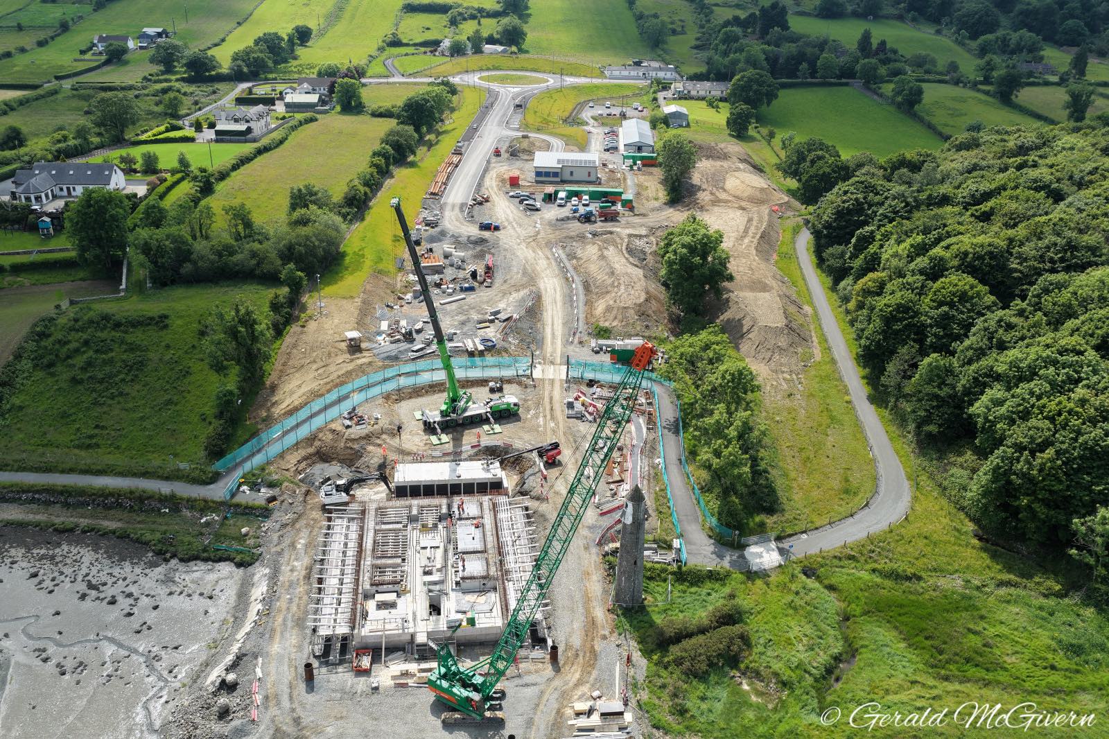
Aerial view of the Louth abutment on 13 June
2025, showing the box tunnel for the Greenway
(which is currently being diverted round the
site, as can be seen). ©Gerald McGivern
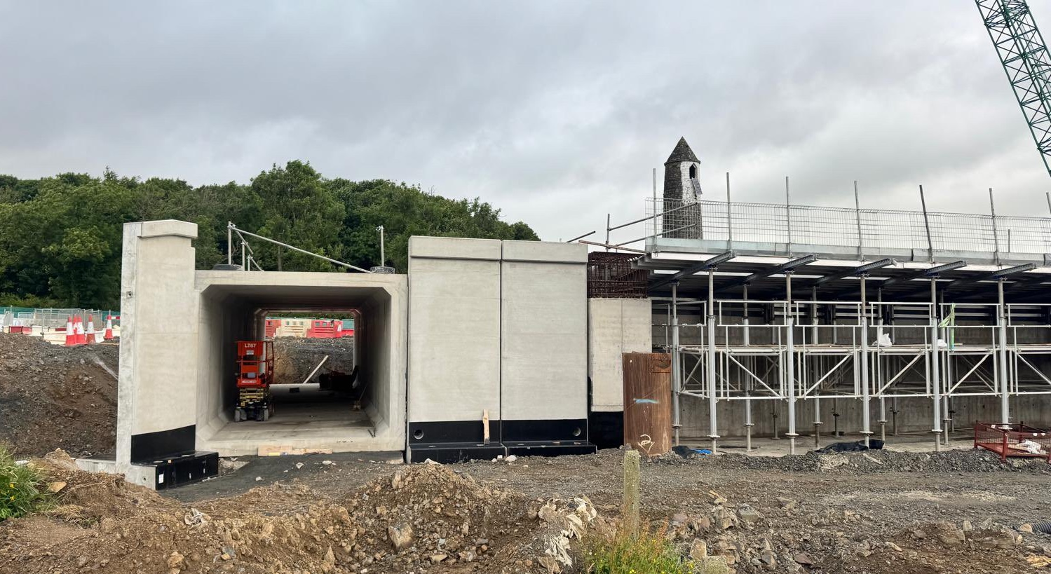
Ground-level view of the box tunnel taken on 27
June 2025, when it was slightly longer than it
was in the earlier photo. The bridge pier is on
the right. The tunnel will be buried in earth
and the road built over the top. ©Joseph
Donnelly.
1 Jun 2025: The ever-attentive Gerald
McGivern has put up another
set of aerial photographs, taken on 30
May. I have reproduced three of the photos below
to facilitate commentary, but there are others
at the link. Work is currently heavily focused
on the two bridge piers, while the future
control room building is externally complete. No
further works have yet taken place on the river
itself following the installation of all the
piles in the spring. There are a few more
comments below the images:
Pic 1: Aerial view of the southern abutment
(Louth end) on 30 May 2025, where a lot of
active work is evident. The structure is now
well above ground level and is being carefully
raised in small steps with large quantities of
steel rebar. Gerald McGivern
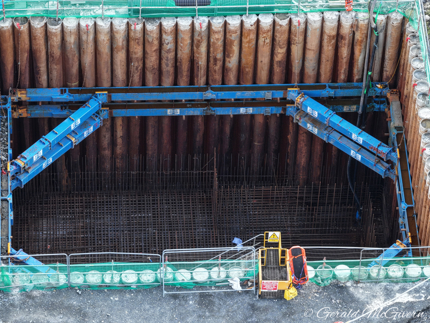
Pic 2: Aerial view of the northern abutment
(Down end) on 30 May 2025. A deep excavation has
been made by driving piles into the ground and
excavated, with a blue frame to hold it open. At
the base workers have arranged a dense network
of rebar. In due course there will be a
significant concrete pour which will form the
foundation of the abutment. The abutment will
then be built on top, in a similar way to the
one on the Louth end. Gerald McGivern.
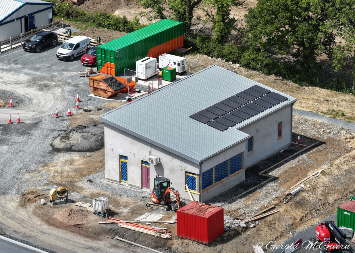
Pic 3: The control room building on 30 May 2025,
which is now watertight and has solar panels on
the roof. Work is probably yet to be completed
inside, but there is no rush with this as it
won't be needed until the bridge becomes
operational in 2027. In the meantime it will
probably be used by the contractor for other
purposes. Gerald McGivern
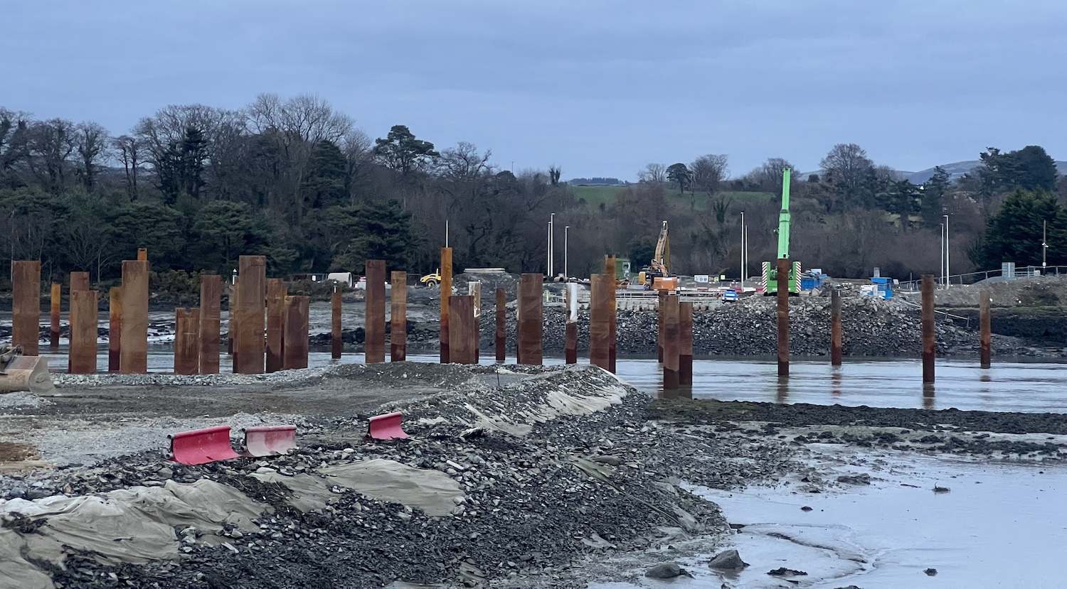
4 Apr 2025: Just a very brief update to
share another aerial
movie by Gerald McGivern. The tide is
fully out in this one, but we get a great view
of the piles in the Newry river. I am certain
now that the bulk of these are designed to
protect the work site from collisions with
ships, but some of them seem to be designed to
act as temporary supports for the bridge deck
during construction.
19 Mar 2025: This update brings a new
aerial movie by the unstoppable Gerald
McGivern plus a couple of ground-level photos.
The main things to note in the video are the
progress on the future control room building
which now has a roof (at 1:00), and the piles in
the Newry river which now appear to be completed
(at 1:25). I am not certain what all the piles
are for, but two sets seem to form a channel for
boats passing through the site. This makes me
think that these ones are designed to protect
the site from impacts from maritime vessels.
Further sets of piles are probably there to
support the bridge deck as its being built.
Finally, three are topped with a concrete beam.
This is located at the point where the lifting
portion of the bridge will meet the non-lifting
portion, so again is likely a temporary
structure to support the deck. This makes me
think that the bridge deck will be built without
the diagonal supporting cables in place. These
will then be added later to take the weight of
the deck, and the temporary structures removed.
At the County Down side you can see (at 01:45)
that the area inside the piles for the northern
abutment have now been excavated to create a
large hole. This will presumably allow the
abutment to be built at depth more easily.
Notably this is different from the construction
method on the southern abutment which was piled
from ground level.
Ground level view of the piles lining each side
of the shipping channel at low water. 4 Mar
2025. [Joseph Donnelly]

Temporary support structure in the middle of the
Newry River which will likely be used as a
temporary support for the bridge deck during
construction. Note the triangular falsework that
forms a platform for workers. 8 Mar 2025.
[Patrick McGivern]
12 Feb 2025: This update is to share a
couple of things. Firstly, this
lovely wide-angle aerial shot of the works
taken by Gerald McGivern on 2 February. It shows
the works to both abutments as well as the
temporary piling platform in the Newry river
being repositioned. I'm still not certain what
this is being used for – but my theory is that
they're to create a temporary structure to
facilitating construction of the main bridge
span. The second thing is this
article in Ground Engineering which was
published today and goes into a lot of depth
about the technical challenges of the piling
works that are being carried out on the scheme,
and the geology of the ground below. This
clarifies that, while BAM is the main
contractor, the piling subcontractor is Quinn
Piling. Work has been underway now for nine
months and the bridge is due to open in 2028.
13 Jan 2025: More photos in this update.
The main change is that a large piling platform
has appeared just off the cost on the Omeath
side of the Newry river, apparently known as the
"Haven Seariser 2". I am not certain what
the platform is being used for, as the site it
is located is beyond the site of the main bridge
pier on this side, but I suspect it is for some
kind of temporary structure to hold up the
bridge deck during construction, as the deck
will need to be cantilevered out from the pier
as the support pylon is built which would
otherwise require some quite finely-tuned weight
balancing. They certainly seem to be busy, as
there were workers on the platform yesterday
(Sunday). You will find some more photos by Gerald
McGivern here, taken on 9 January. The
four photos below were taken by Joseph Donnelly
on 11 January (thank you). With thanks to Brian
McCalmont via Patrick McGivern for some of the
info in this update.
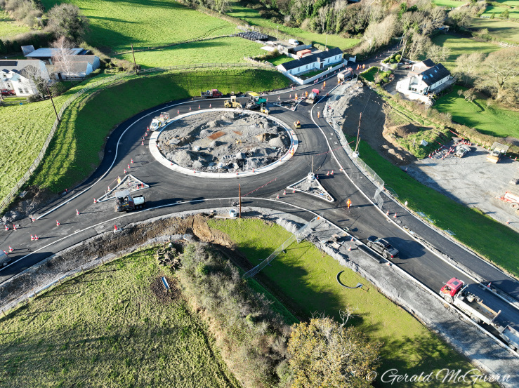
Pic 1: The completed roundabout at the County
Louth end of the scheme, with the temporary site
yard below. 11 January 2025 [Joseph Donnelly]
Pic 2: The future control room building for the
bridge seen on 11 January 2025, with workers now
at roof level. [Joseph Donnelly]
Pic 3: Progress on the foundations for the
bridge pier on the south (Louth) end of the
scheme on 11 January 2025 with a piling platform
now positioned in the mud to the right. [Joseph
Donnelly]
Pic 4: Closeup of the platform seen in pic 3 on
11 January 2025. There is a pile driver and
crane (presumably for lifting the piles) working
on the platform. I suspect this is to construct
a temporary support for the bridge deck. [Joseph
Donnelly] 31 Dec 2024: Gerald McGivern posted
another drone
video just before Christmas, taken on 20
December. At the start of this video we can see
that the roundabout on the Louth end of the
scheme has now been completed and is fully open
to traffic. Work on the services building is
ongoing as can be seen at 0:15 in the video. At
0:24 you can see work on the principal
(southern) pier of the bridge which is now a
couple of metres above ground level. At 0:30 and
the minute following you see a close-up of work
on the secondary (northern) abutment at the
Warrenpoint side. I am not certain what they are
doing, but it looks to me like a large
cylindrical pile is being pushed into the
ground, displacing ground water. A ground-level
view of the same spot was taken two days earlier
by Vincent Kearney and is visible here.
Work is paused for the holidays but will
presumably resume in January as the scheme
enters its second calendar year. The bridge is
due to open in early 2028, i.e. about three
years from now.
12 Dec 2024: This update is to share
another set of drone
footage, taken on 9 December by Gerald
McGivern (thank you to Gerald for doing this and
sharing it publicly!) as well as some images
which Gerald shared on 28 November, used with
permission (gerald@seehigher.com). The drone
footage begins at the roundabout on the County
Louth end of the scheme, which is now
essentially completed but yet not operating a
roundabout. At 0:30 you can see a building under
construction - this is a permanent structure
which will house a generator room, a maintenance
area and a control room for lifting and lowering
the movable part of the bridge. At 0:50, and the
minute after, we see the foundations of the
principal (southern) pier of the bridge which is
now rising up above ground level. The blue/green
fences are a public Greenway that is currently
diverted around the site during the works. At
1:35 we transfer to the County Down side of the
bridge, where the smaller (northern) pier is
under construction. This pier is less advanced,
with puling work underway on a temporary rock
platform. Although a smaller pier, this is the
one upon which the moving section of bridge will
rotate, so it still a complex structure. The
rest of the video is made up of further still
images. Below are four of the still images that
were taken on 28 November.
Pic 1: The roundabout at the south end of the
bridge on 28 November 2024, largely complete,
but with all traffic passing round one side of
it. Credit: gerald@seehigher.com
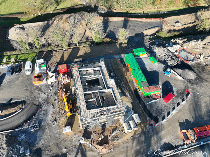
Pic 2: Control room building for the bridge
under construction on 28 November 2024. The
control room is the one at the bottom right,
while the room at the top is for an electrical
generator. Credit: gerald@seehigher.com
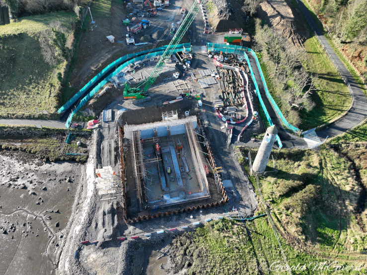
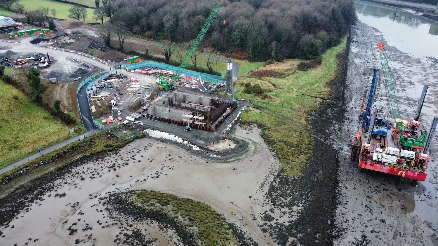
Pic 3: The main, southern, pier seen on 28
November 2024. The foundations are complete and
work is now underway to construct the bottom of
the pier itself. Credit: gerald@seehigher.com
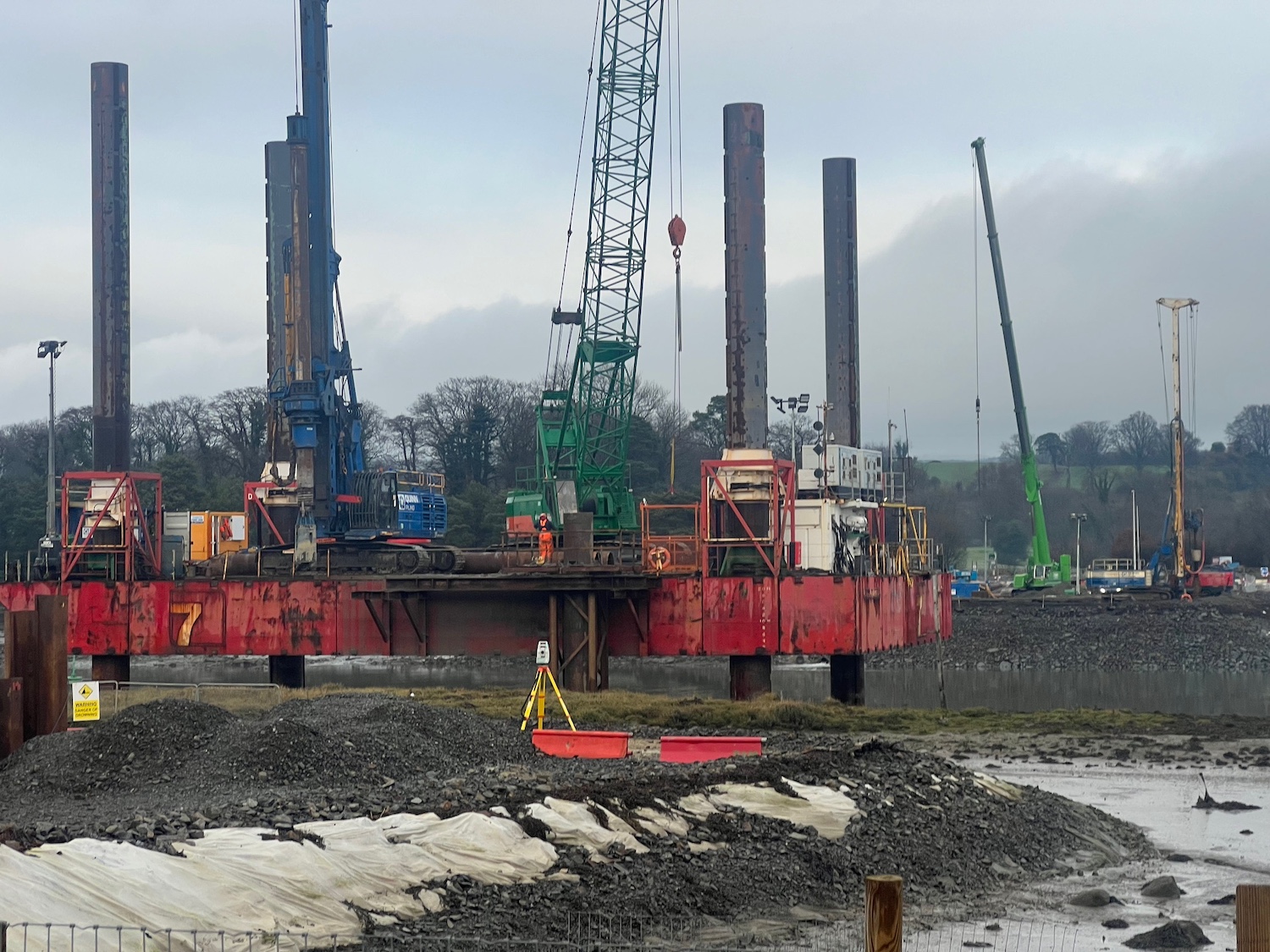
Pic 4: Stone platform in the Newry river to
facilitate foundation works for the northern
bridge pier, 28 November 2024. The tall, white
piece of machinery is a pile driver which is
inserting piles for the foundations. Note that
although new culverts have been added under the
roundabout, they don't appear to be fully in use
yet with water still flowing out of the old one.
Credit: gerald@seehigher.com 27 Nov 2024: No new photos to show you,
but this update is to say that work has been
underway throughout November on both piers of
the new bridge. Piling rigs have been operating
at the northern (county Down) end since the
start of the month. Work is also continuing on
the southern (county Louth) pier which is the
larger of the two, and is also the more
advanced. The First Minister Michelle O'Neill confirmed
two weeks ago that the bridge is due to be
completed in "late 2027" (this is a bit later
than the mid 2027 date I had been working to,
but in fairness that was my calculation rather
an official information) and is due to be opened
to traffic in 2028.
28 Oct 2024: Work has now been underway
for five months and a lot of progress has been
made. The main source for this update is this
drone footage, taken on 17 October by
Gerald McGivern. Thank you to him and to Patrick
McGivern (no relation) who alerted me to it.
Starting at the south, the first thing to note
at the start of the video is that the roundabout
is largely completed except for the existing
road passing through the centre. Traffic will
almost certainly be diverted round the south
side of the roundabout soon to allow completion
of the roundabout, after which it will come into
use and serve as a safe access route into the
site. The first part of the approach road to the
bridge is also completed (though presumably
without the final layer of tarmac which could be
damaged by construction vehicles if laid too
soon), as well as a temporary access road to the
site yard. As the drone approaches the Newry
river you can see the site of the primary bridge
pier. It looks like piling works here are now
complete within the square cofferdam that
surrounds the site. Erne Concrete Pumping posted
at the start of October that they had been
involved in a concrete pour into the lowest
level of these foundations. It's hard to see
detail in the drone footage, but it looks to me
that work is now underway to form the
reinforcing bars for the next stage of the
bridge pier above the foundation. This is the
larger of the two bridge piers, so is where most
of the bridge's weight will rest, so it needs to
be very secure. The drone footage then crosses
the river to the County Down side. The smaller
of the two bridge piers will be located here,
and the foreshore is currently being infilled
with rock. It's not certain whether this is a
permanent infill, or just a surface to allow
construction vehicles to get out onto the
foreshore. It does appear to get partly
submerged at high tide. Either way, we will
likely soon see piling works going on here to
create the foundation for the northern bridge
pier. The footage also shows the old route of
the watercourse under the roundabout, and its
new course to the left which takes it away from
the bridge works. The picture below was taken
from ground level on the County Down side.
Picture taken on the County Down side of the
bridge on 14 October, with the existing
Warrenpoint roundabout off shot to the left. The
road roller is smoothing down rocks which have
been pushed out onto the tidal mud flats. The
future bridge pier on this site will be situated
between the vehicle and the pile of rocks on the
right. [Patrick McGivern]
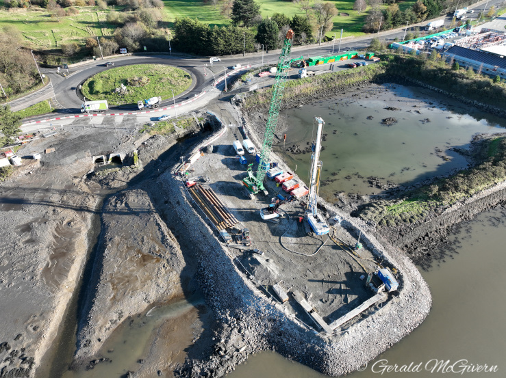
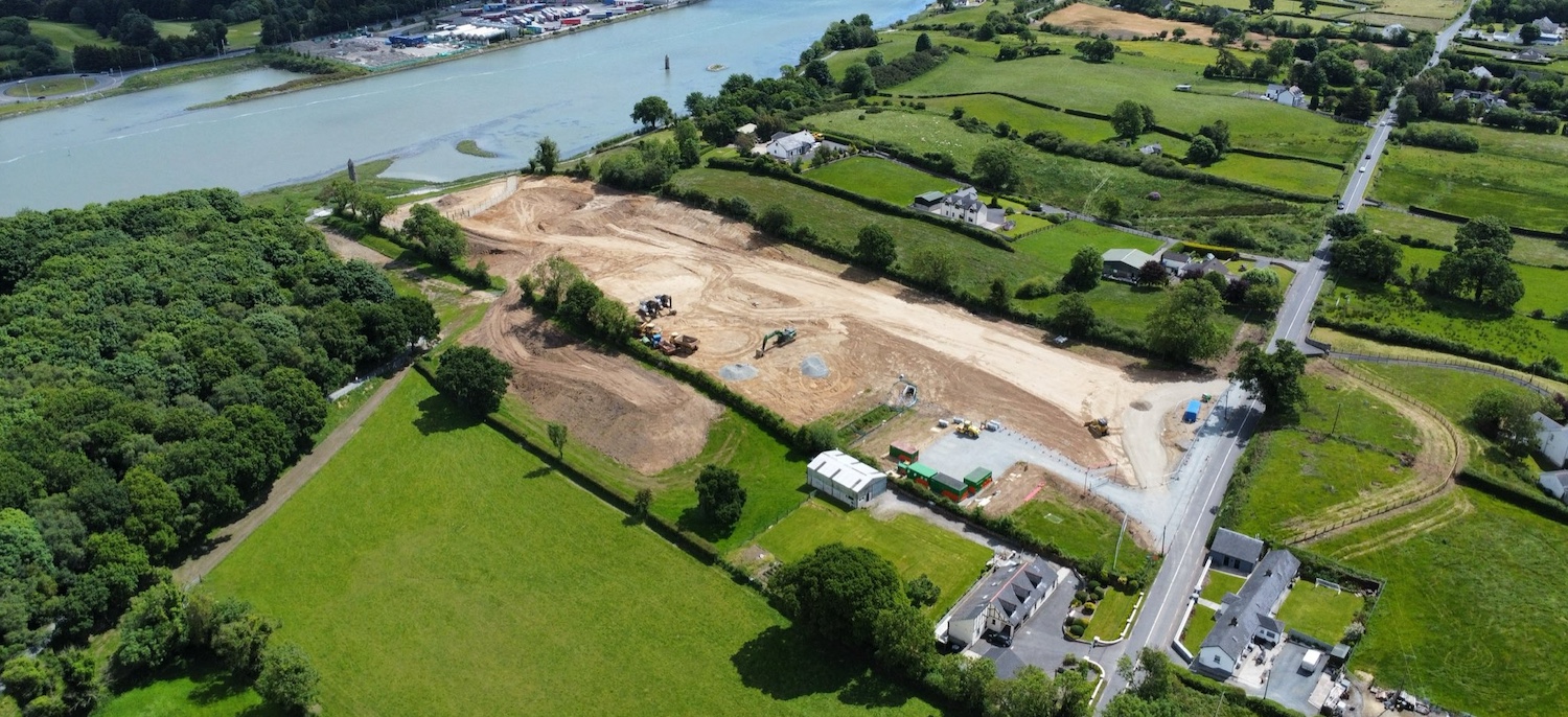
29 Aug 2024: This update is to share the
photo below, which was taken by Joseph Donnelly
(thank you) and shows progress in the three
weeks since his previous photo. You can see
that, as I predicted in the previous update,
work has been taking place to build the western
half of the new roundabout on the R173.
Presumably traffic will diverted onto it once
it's completed so that the eastern half of the
roundabout can be built. As well as that, the
short link road from there to the site of the
bridge is also well underway and seems to be
being surfaced with a base layer of tarmac. As
this will be used to access the site of the
bridge itself, it probably won't get its final
wearing course of tarmac until close to opening.
The pile driver is still on the site of the
western bridge pier, but it's not clear from the
air whether the cofferdam has been completed
yet. Work is likely to be taking place on the
foundations for the bridge piers for some months
to come, a very difficult job in challenging
ground conditions. It's a complex project which
is why it has still almost three years to run.
Aerial view of the Louth side of the scheme on
27 Aug 2024 [Joseph Donnelly]
16 Aug 2024: In the six weeks since my
last update, quite a lot of progress has been
made. I have shared three photos below, but I
also want to link to this
set of photos on Facebook which was posted
by Gaz Drone Photography two weeks ago. Two of
those aerial images show the major works on the
Louth side of the scheme. Firstly, in the
distance, you can see that the land for the new
roundabout on the R173 has been fenced off. As
can be seen in photo 1 below, a temporary road
allowing traffic to bypass what will be the
centre of the roundabout has been built, so
presumably work is going to begin on the western
half of the roundabout shortly. Closer to the
shore, a huge square cofferdam was completed in
late July (see photo 2 below). This completely
surrounds the site of what will be the larger
(western) bridge pier. This will create a
watertight work area to allow the foundations
for the pier to be excavated and constructed.
Nearby, a large steel structure has appeared at
the site (see photo 3 below). Those more
knowledgeable than me tell me that it is a rig
for carrying out static load tests on the
foundation piles after they've been piled into
the ground. Between the cofferdam and the future
roundabout, the base for the approach road seems
to be taking shape with an excavation at one
end, and an embankment at the other. My guess is
that the approach road is going to be built at
an early date to allow the contractor to more
easily get heavy plant equipment and bridge
materials to the site of the bridge itself once
the structure starts going up. On the County
Down side of the bridge, where the smaller pier
will be located, the scale of work is more
limited, and so far has only involved the
re-routing of two culverts which until recently
entered the Newry river directly beside the
roundabout. They now enter the river slightly to
the north, to facilitate the future road/bridge
connection. An image of this is also visible on
the Gaz Drone Photography link above. With
thanks to all those who send me updates, and to
those who responded to my Twitter query about
the purpose of the static load test rig!
Aerial view of the Louth side of the scheme on 5
August 2024 [Joseph Donnelly].
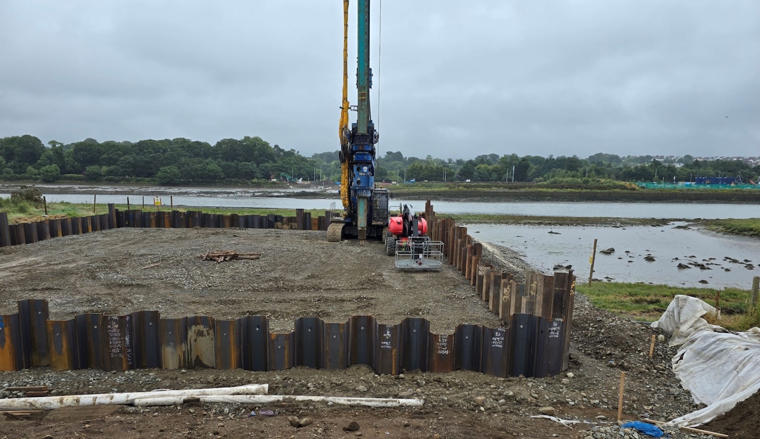
Cofferdam that has been built on the Louth side
of the site, seen on 15 Aug 2024 [Louth County
Council].
Large steel piling test rig that has appeared at
the Louth site, seen on 15 Aug 2024. It will be
used to verify that the piles on this soft
ground are sufficiently firm to take the weight
of the bridge pier. [Louth County Council].
5 Jul 2024: The pictures below were
taken on 2 July by Patrick McGivern (thank you)
and show progress on both banks of the river.
The first shows earthworks on the Louth side –
most notably a large pile driver close to the
bank, which is almost certainly starting work on
the foundations of the larger of the two piers
of the bridge, which will be located on the
south side of the bridge. Meanwhile, on the
County Down side (where the existing road is
directly adjacent to the river) part of the
roundabout has been coned off and earthworks
appears to be underway. Some large concrete pipe
sections have appeared here. As the second -
smaller - bridge pier will be located several
dozen metres out into the channel on this side
of the bridge, site access from the roundabout
will need to be established. So the pipes may
for use in constructing an access route out into
the water. If so, they will be laid in the water
to allow the tide to pass through. Time will
tell!
View of the County Louth bank on 2 July 2024,
with a pile driver prominent on the left, likely
piling for the foundations of the larger of the
two bridge piers. [Patrick McGivern]
Works on the Co Down side of the
bridge on 2 July 2024, seen from adjacent to the
existing roundabout. Earthworks have been built
in the water, with silt barriers. The County
Down bridge pier will be built beside the strip
of land visible on the right, so construction
teams will need a way to get out to there. The
pipes may be for use in constructing such an
access route. [Patrick McGivern]
19 Jun 2024: The DFI Minister was
on
site with his Dublin counterpart two weeks
ago to mark the start of construction. We have
two more photographs taken since then that show
progress. You can see the the site yard on the
Omeath side is now in place with a gravel access
road and portable buildings. The rest of the
field has now been dug over. There are more
notes in the captions. On the Northern Ireland
side, workers this week were installing barriers
at the roundabout on the A2 where the bridge
will terminate. There are likely to be lane
closures on the roundabout for some time to give
space to work.
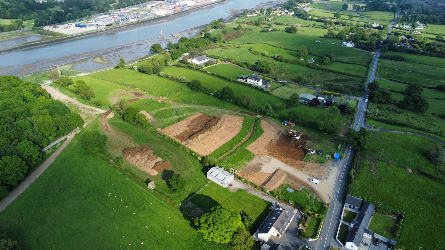
BAM's site yard (bottom right of brown field) in
place on the Omeath side on 8 June 2024. On the
lower right the land for the future roundabout
has been fenced off, with what might be a
temporary diversion for the main road being
built on the left side of the road. Nearer the
river, the Greenway has been diverted slightly
inland away from the water's edge. [Joseph
Donnelly]
View from County Down towards the Omeath side on
15 June 2024. Excavators can be seen lowering
the level of the site by several metres. This
excavation is probably going to be filled in
again at a later date to form the base of the
bridge access road. Temporary gravel access
roads have been built for the machinery. The
tower is Cornamucklagh Round Tower, which is
nowhere near as old as it looks. It is a
navigational tower for the Newry river dating
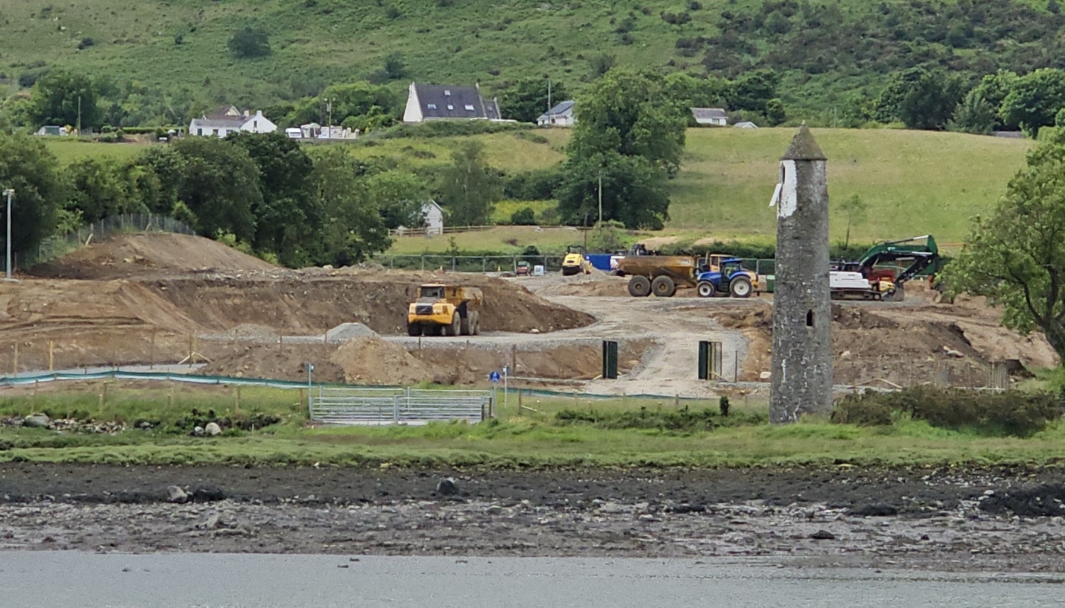
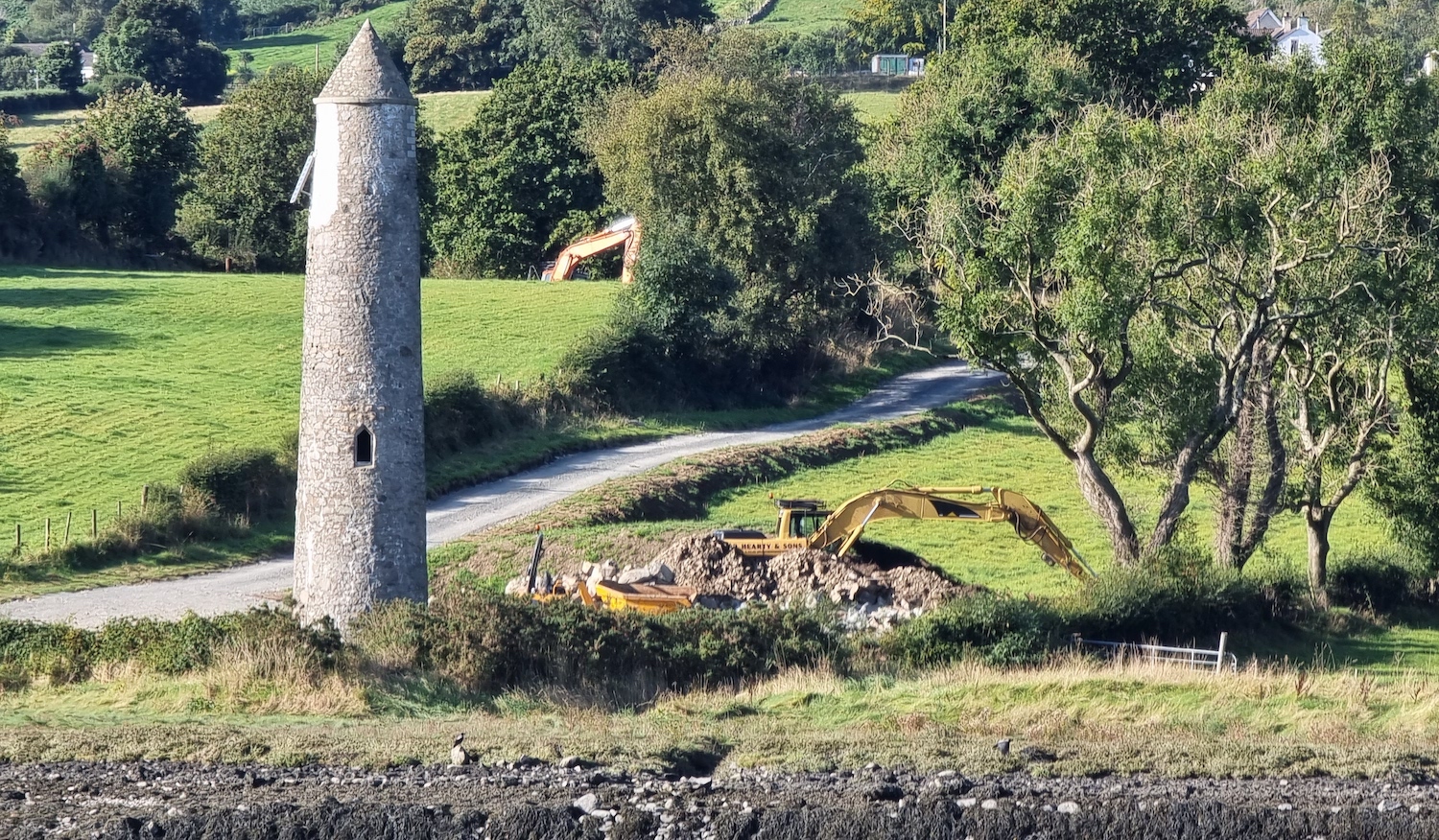
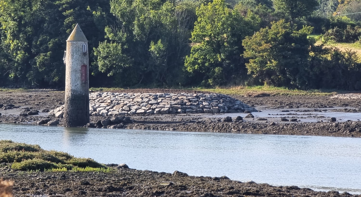
from the 1800s. [Patrick McGivern]
24 May 2024: It was confirmed on 13 May
that BAM Ireland have indeed been appointed to
build the bridge. Over the past week the
contractor has built a site yard on the Omeath
(Louth) side of the river and and, as work
'officially' began today, I would expect to see
evidence of earthworks getting underway over the
next week or so. The initial months will most
likely consist of ground preparation works, of
which the most extensive will be the foundations
needed for the two bridge piers. It's unlikely
that we will see much appear above ground level
in the first year. Nevertheless (and especially
with drones now widely available) this will be
an interesting scheme to watch. I have now moved
this scheme to the "Under construction" section
of the site. This ends a period when there have
been no major roads under construction (partly!)
in Northern Ireland since St Patrick's Barracks
Link Road in Ballymena was completed eleven
months ago.
BAM's site yard under construction on the Omeath
side of the channel circa 22 May 2024. The
future road will run along the far boundary of
the field that the site yard is in, and
terminate in County Down at the top left of the
image. [Joseph Donnelly].
8 May 2024: Still no official word on
who the winning contractor is, though BAM seems
to be the one being named. Sub-contractors have
been hiring
for the project. Work is due to get underway on
24 May 2024 – just over two weeks from now! The
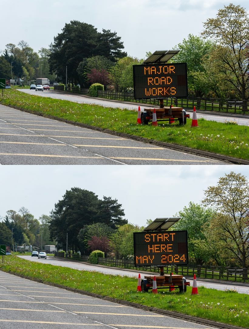
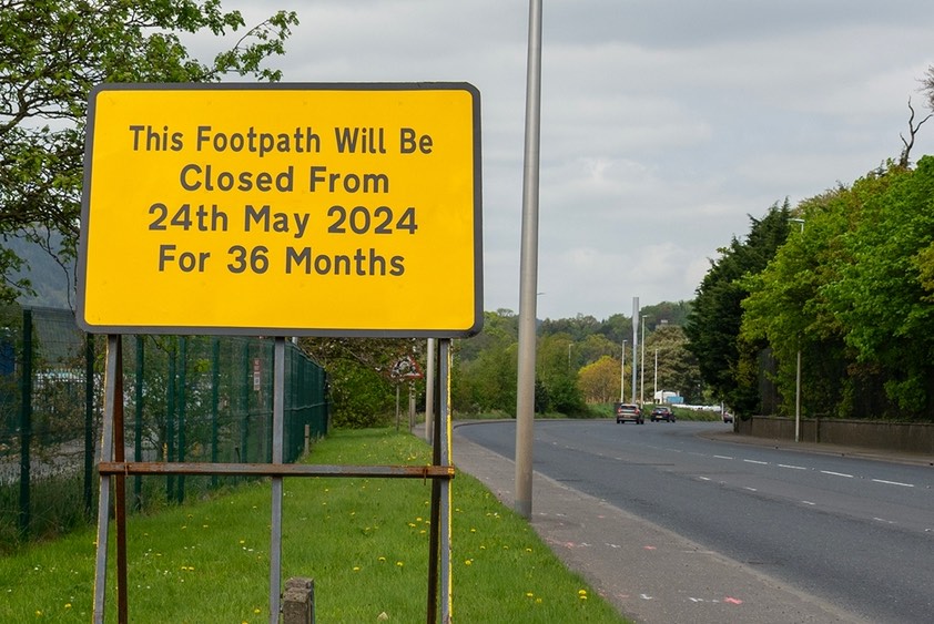
photo below was taken at the weekend by Brian of
Old Warrenpoint and shows the signage that has
appeared. Another sign nearby on the footpath
confirms the date as 24 May and gives the
duration of the project as 36 months, as
expected. So we can expect completion by the end
of spring 2027. This will be a very interesting
project to watch happen over the next three
years.
17 Apr 2024: Word on the street is that
a winning contractor has been selected for this
scheme, and that the tender will be formally
awarded by Louth County Council in the near
future. BAM has been mentioned as the likely
winner, but we will see. Construction is likely
to begin very quickly, perhaps next month (May).
21 Feb 2024: Yesterday the Irish
government announced
a range of funding for cross-border projects.
Narrow Water Bridge was one of them, though they
did not specify the amount (but estimated to be
around €60m). This may be because Louth County
Council are shortly to award the construction
tender. The scheme has been out to tender since
late 2022. The tender award is likely to happen
by the end of June, and possibly sooner.
Construction could then get underway fairly
quickly as all the various permissions are
already in place. So I would expect to see work
on the ground ramping up during the summer. We
would then see the bridge completed by mid 2027.
Today Pat McGivern spotted some land clearance
underway on the county Down side of the bridge
site adjacent to the existing roundabout (see
photo below). If it's related to the bridge –
and it's hard to see what else it could be – it
might be either to ensure vegetation is cleared
before the bird nesting season, or it might be
to prepare the site in more general terms for
the contractor to use when setting up. It is now
virtually certain that this scheme will happen.
Clearance works underway at the County Down side
of the bridge site on 21 Feb 2024. You can see
the existing roundabout on the left. [Patrick
McGivern]
1 Nov 2023: Last month I reported some
site preparation works taking place at Narrow
Water. I commented that the works might be
unrelated to the bridge, and alas this turns out
to be the case. The works evident are do do with
the new Greenway being developed. The official
position of Louth County Council remains that
work is due to get underway on the bridge itself
in the first half of 2024, so a little longer to
wait.
6 Oct 2023: In the last update I said
I'd anticipate work getting underway on the
ground before the end of 2023. However, since
then, Louth County Council has indicated
that it is more likely to be the first half of
2024 before this happens. I am not sure why it
is taking so long given that the tender process
has been underway for over a year now, but they
are certainly correct. Assuming a three year
construction process this would mean an opening
around summer 2027. Low-level works have been
underway on the Louth bank of the site for some
months now. The photo below was taken last month
by Liam Rice (thank you). It shows topsoil
removed just to the north side of the round
tower. This is not the route of the road (it
will run to the left of the tower in this view)
so I think this is likely to be preparatory work
for a site yard or for a temporary works area.
(Of course it may be completely unrelated to the
bridge – but with nothing else to report you
can't blame observers for clutching at straws!)
View south-west across Narrow Water from County
Down towards County Louth, on 19 Sep 2023 [Liam
Rice].
28 Apr 2023: The tendering process now
appears to be in a second phase, and tenderers
have until the start of June to submit their
bids. Since funding and planning permission are
in place, I would anticipate construction to get
underway before the end of 2023 which would be
great. There has been some talk
in recent months about naming the bridge after
US President Joe Biden, given that he has family
connections to County Louth. However at this
time the current name of Narrow Water Bridge
remains the favourite.
25 Nov 2022: The Irish Taoiseach visited
the site of the scheme last week, and announced
the commencement of a tender process for
construction of the bridge. This was really just
a publicity opportunity for Micheál Martin, who
ceases to be Taoiseach next month, because the tender
was actually released almost three months ago on
5 September (as reported in my previous update
below), with a closing date of 23 November. So
with the tendering now closed, effort is now
going to turn to evaluating the tenders. I would
anticipate a contract award before too long,
perhaps early in the new year, which would allow
the winning contractor to start ramping up
equipment at the site. I get the sense that
money is unlikely to be an issue this time round
(compared to the unsuccessful tendering process
in 2013) so I fully expect to see work getting
underway during 2023, hopefully by the summer.
An exciting time for South Down / Louth!
22 Sep 2022: The construction tender for
this scheme was finally released
during the week of 5 September. The total
estimated value of the tender is €60m, which is
considerably higher than the tenders of €26-40m
received when the scheme last went out to tender
ten years ago. Given that cost under-estimates
were the root cause of the collapse of the
scheme at that point, it is good to see more
realistic cost estimates being given this time
round. Contractors have until 9 November to
submit their tenders. Since the bridge has
already passed all its legal and statutory
hurdles, construction could start immediately
upon the appointment of a winning tender, which
means we'll hopefully see work getting underway
during 2023. Construction is due to take three
years, meaning completion in 2026. With thanks
to Pat McGivern for letting me know about this.
The photos below show some preparatory works
already taking place.
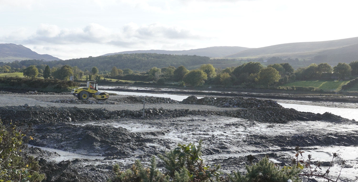
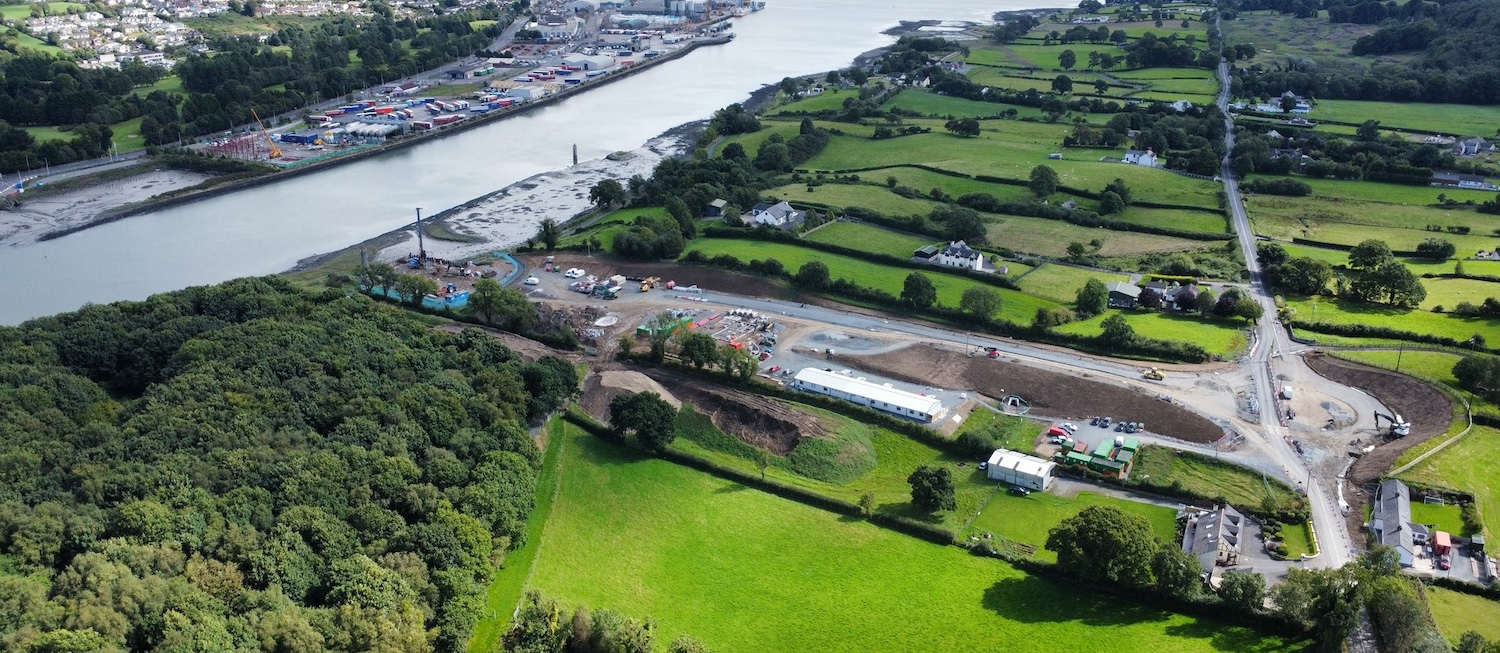
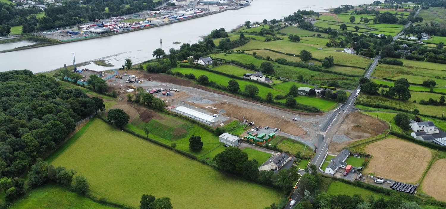
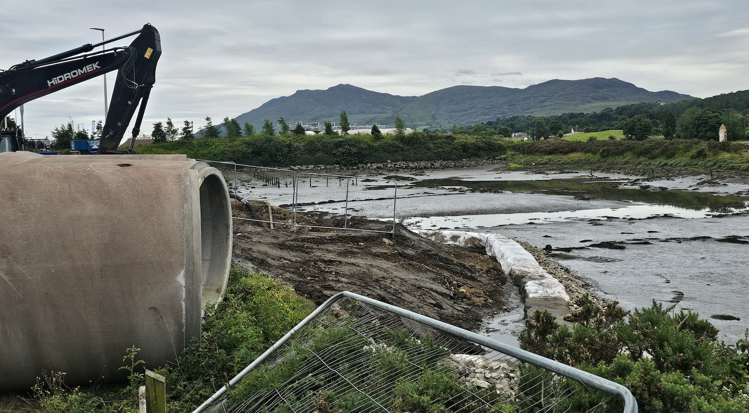
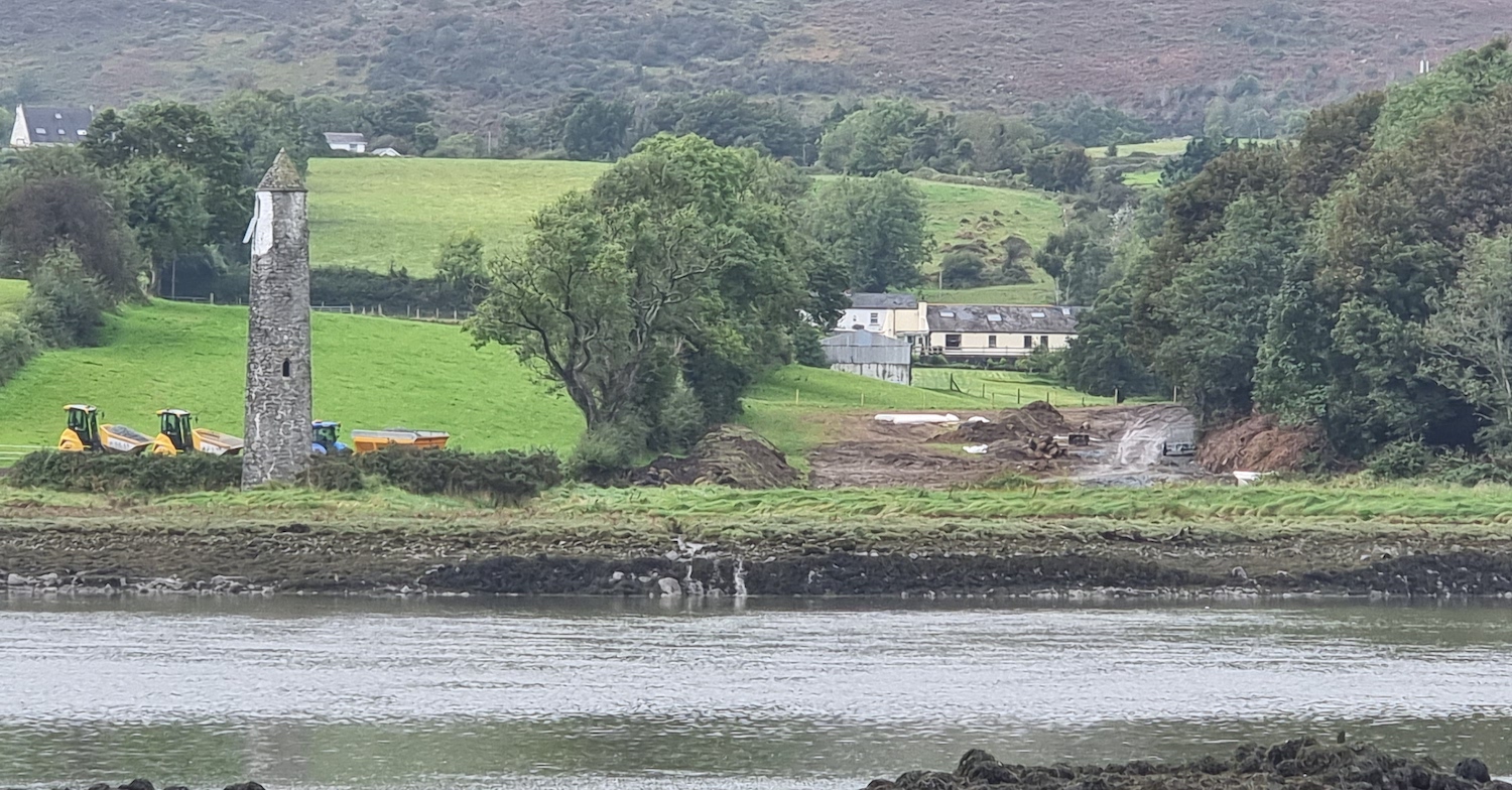
Site access being prepared on the Louth shore of
Narrow Water, ready for work to begin in 2023.
[Pat McGivern]
Recently-completed bird refuge at Narrow Water.
This is intended to assist birds whose
activities will be disturbed by the construction
of the bridge. [Pat McGivern]
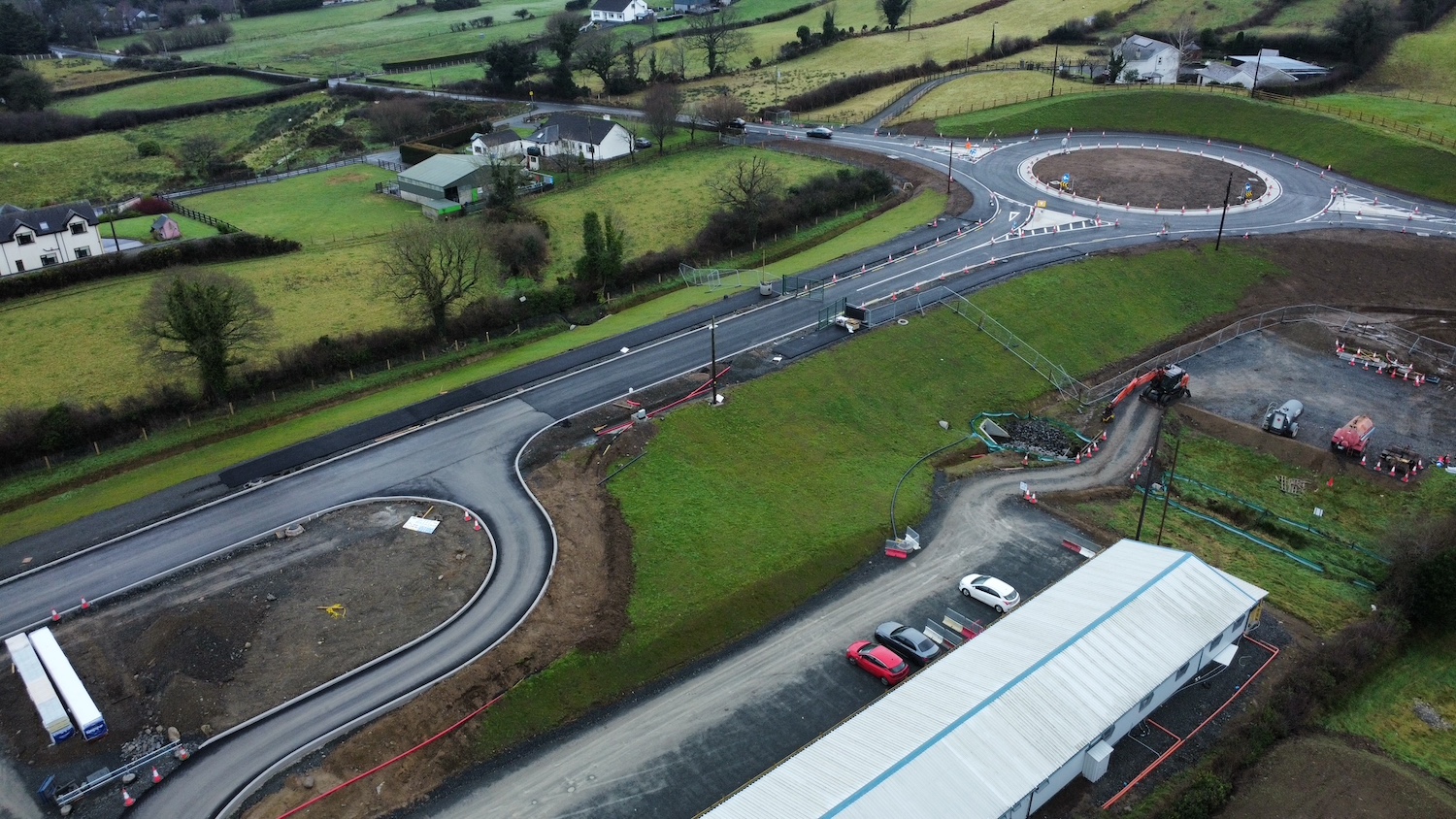
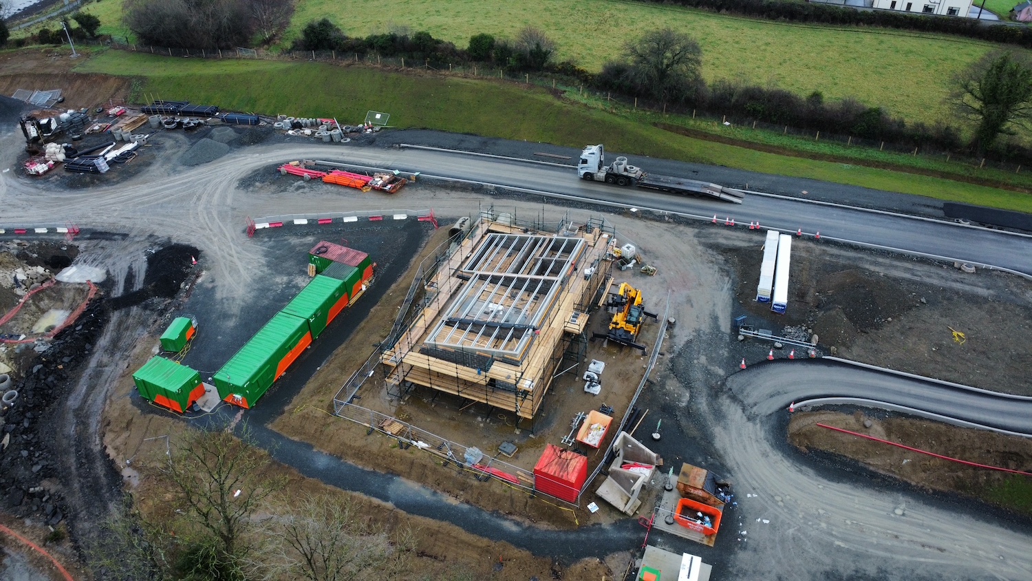
15 May 2022: On 26 Mar 2022 the DFI
Minister "made"
the Bridge Orders for the Narrow Water Bridge.
These are the legal documents required (on the
the Northern Ireland side of the bridge) for DFI
to have the authority to build a bridge over a
navigable river. In this case, the bridge will
feature a lifting section at one end that will
preserve navigation. The DFI press release notes
that this will allow Louth County Council to
bring the scheme to procurement (i.e. to release
the construction tender). The Irish government
provided Louth CoCo with €3m last summer to
assist this part of the process. I am still
anticipating the tender to be released sometime
this year so things may well continue to move.
(The lack of an Executive in NI should not be a
major problem as the project is being
spearheaded by Louth CoCo.)
2 Mar 2022: The DFI Minister was asked
about this scheme in the Assembly a month
ago. In her reply she confirmed that the project
is being prepared to go back out to construction
tender by Louth County Council (the same body
that was responsible the last time this happened
ten years ago). However, she said that DFI are
"working closely with Louth County Council to
complete the processes" required to make this
happen. She also confirmed that the design being
used for the bridge is the same design that was
tendered in 2012. She again said that it is
hoped that work could commence in 2023, subject
to the usual caveats that everything has to
navigate the statutory processes.
29 Nov 2021: The DFI
Minister met the Irish Minister for
Housing, Local Government and Heritage
(HLG&H) about six weeks ago on 15 October at
the site of the planned bridge, as well as local
people. They confirmed that the subgroup of the
North-South Infrastructure Group (mentioned in
the August update below) has been established to
progress the scheme. The DFI Minister also said
that she and her southern counterparts are
planning to enhance the walking/cycling
infrastructure leading to the bridge on both
sides. The Irish HLG&H Minister again stated
that work would begin in 2023, subject to the
successful completion of the statutory processes
and appointment of a contractor, so the schedule
still seems to be sticking, which is good news.
(The DFI Press Release once again incorrectly
asserts that Narrow Water Bridge was a key
commitment of New Decade, New Approach – DFI
continue to repeat this line!)
22 Aug 2021: Work on this scheme seems
to be progressing swiftly now that it has
commitments on both sides of the border. At the
end of June the
Irish government allocated €3m to
development work on the project from the new
Shared Island Fund, and indicated that further
funding would be forthcoming for construction
once it was progressed to that point. A tender
is likely to be released within the next year.
The last time the project went out to tender
(but did not proceed to construction) it was
managed by Louth County Council. This time it
appears that a subgroup of the North-South
Infrastructure Group will be formed to take this
role. This would include Louth CoCo, but also
Newry, Mourne and Down District Council.
Construction is currently anticipated to begin
in 2023 (though technically work began in
November 2017, when a small amount of work took
place to prevent planning permission expiring).
While infrastructure projects are very prone to
delays, this scheme certainly seems to have a
fair wind behind it at this point.
5 May 2021: The scheme seems to have
been discussed at today's
meeting of the North-South Ministerial
Council, though nothing of any substance was
said. In February the Infrastructure Minister
held a meeting with Newry, Mourne and Down
Council, and Louth County Council and then put
out a press
release affirming her commitment to the
scheme (though again implying that it was a
commitment of the 2020 New Decade, New
Approach document, which it was not). She
said "I am committed to the delivery of this
iconic project that will allow so many
untapped opportunities to open up for South
Down and Louth." There appears to be
political will on both sides of the border to
build this bridge, so the sticking point seems
to be who will pay for it. To this end, the
Minister was asked
about the project in the Assembly on 26 April.
She replied that "I remain committed to
working with Minister Eamon Ryan and the
Taoiseach's office — I am very mindful of the
Shared Island Fund — so that we can move the
project forward", so this may well be how
it is being approached. The last estimate of the
construction cost, eight years ago, was between
€26m and €40m. DFI, for their part, are calling
the ongoing planning costs for the scheme as
"pre-committed" in their budget with £5m set
aside for this financial year.
22 Dec 2020: As we approach the 14th
anniversary of the genesis of this scheme, it
has continued its newfound momentum as noted in
October's update below. In a Question
for Written Answer in the Assembly in
early November, the DFI Minister said "The
Narrow Water Bridge is a commitment in New
Decade, New Approach and is currently at
options analysis stage and my officials are
working to update an economic appraisal of
options for development in collaboration with
Southern colleagues in the Department for
Transport." (Note that while New Decade,
New Approach (NDNA) mentions Narrow Water Bridge
as an example of the kind of schemes that the
Executive might choose to fund, I do not read it
as a commitment in NDNA.) Nevertheless, a recent
DFI document setting out their financial
priorities lists Narrow Water Bridge as
"pre-committed" under NDNA, with a cost for the
next financial year (2021-22) of £5m, which is
presumably for ongoing planning costs. It's
still not clear where the money for the bridge
will come from, and how the cost will be split
North-South, but it certainly looks as if the
Minister is committed to progressing with it.
29 Oct 2020: This scheme seems to be
regaining the momentum it had before its
collapse during the previous attempt to proceed
to construction seven years ago. Firstly, two
weeks ago the Irish government announced
the creation of a Shared Island Fund, which will
have funds of €500m over the next five years to
invest in all-Ireland projects. The fund will be
used for various purposes, but cross-border
infrastructure projects seem to be high on the
agenda, especially roads, rail and greenways.
They explicitly mentioned Narrow Water Bridge as
one of the schemes that they would be interested
in funding. So this suggests strong Irish
government support. We already know that the
current Infrastructure Minister in Northern
Ireland is also very supportive of the scheme,
so there would seem to be few obstacles now to
making progress. At a DFI Weekly
Business Review Meeting four weeks ago, it
was noted that DFI has been instructed
(presumably by the Minister) to "prepare a
paper on options for taking forward Newry
Southern Relief Road and Narrow Water Bridge
projects". This was ahead of the Shared
Island Fund announcement, but dovetails nicely
with it. So I would expect to hear more about
this scheme in the coming months.
11 Sep 2020: It is now almost seven
years since the last attempt to build this
bridge collapsed due to a combination of
unrealistic cost estimates and inadequate
funding. A lot has changed in that time, not
least the collapse and reinstatement of Stormont
and now the tenure of Nichola Mallon as DFI
Minister who in recent weeks has gone out of her
way to signal
her support for the scheme. Two days ago
she was photographed with the Narrow Water
Bridge Community Network and local
representatives and stated
that she supported the scheme, and commented in
particular that DFI is now working with the
Republic's Department for Transport, Tourism and
Sport to develop the project. So with political
will apparently there on both sides of the
border we could see some further movement on
progressing this scheme within the next year or
so.
27 Feb 2020: The "New
Decade New Approach" agreement that was
reached in early January included references to
this scheme. The British government section
merely listed Narrow Water as an example of the
type of scheme the new Executive might choose to
fund, without making any explicit commitments to
it. The Irish government did not commit any
funds either, but did say "The [Irish]
Government is also ready to jointly progress
consideration of options for the development
of the Narrow Water bridge project at the
[North South Ministerial Council]". In
other words, they're happy to discuss options
for progressing the scheme with their
counterparts at Stormont. This position is
repeated in a recent Written
Answer by the new Infrastructure Minister
when she was asked about the scheme. She said "I
will be reviewing the options that have been
considered to support future development of
Narrow Water in coming weeks. I recognise the
importance of the Narrow Water Bridge project
in linking the communities on both sides of
the lough and maximising the tourism potential
of this cross border region whilst protecting
the natural environment in this area of
historic and ecological significance."
This is not a committment to progress the scheme
either, but it does indicate that she is
sympathetic to discussing the matter with the
authorities in Dublin. We shall have to wait to
see if it is discussed at the next Transport
Sectorial meeting of the NSMC, which last met in
December 2016, shortly before Stormont
collapsed.
5 Nov 2017: Planning permission for the
Northern Ireland side of the bridge was due to
expire on 24 October 2017, since planning
permission lasts 5 years here. However, a quirk
of the law here means that once a "substantial
start" is made the clock stops and the duration
of planning permission is effectively unlimited.
For this reason Louth County Council seem to
have sent
a contractor to the Northern Ireland side
on the day in question and made a "substantial
start" on the bridge, which appears to mean some
preliminary earthworks. This is likely to
have worked, meaning that for the time
being the expiration of planning permission is
not an issue. However, there is still
insufficient funding for the scheme from either
Dublin or Belfast, and no functioning Executive
in Northern Ireland, and so there is no sign of
if or when further work might get underway.
10 Jul 2017: Concerns were expressed
yesterday by an economic development body that
Narrow Water Bridge is about to encounter
another setback in that the planning permission
on the Republic of Northern
Ireland side is set to expire in October this
year. If it does, then the planners would have
to re-apply for permission. In Northern Ireland
beginning work is sufficient to stop the clock
on expiration (even a few days of topsoil
removal would be sufficient) but the same is not
true in the Republic. The implication was that
the continued non-existence of the Stormont
Assembly was preventing planning for the scheme
progressing. While this is true, I think the
story is bit of a red herring as commencing work
by October this year has been off the table for
some time already. Firstly, no contractor has
been appointed and the process of doing so would
take several months by itself. So even if we
began tomorrow, there's no way a contractor
could be in place and work underway by October.
And secondly, even before the Assembly collapsed
the DFI Minister Chris Hazzard was talking
as if he did not expect work to begin until
2019, and even that was assuming the scheme was
being progressed "as a priority" - a much more
plausible timeframe in my view. So unless the
planning permission can be extended somehow,
which depends on the flexibility of the
authorities, I think having to re-apply for
planning permission is the most likely outcome.
28 Jan 2017: Very little progress has
been publicly reported about this scheme over
the past few months. However, the outgoing DFI
Minister Chris Hazzard has released two press
releases a week apart specifically mentioning
the scheme and giving some more information. In
a press
release on 16 January he said "A
meeting is now being arranged with key
stakeholders to identify the preferred option
for the Narrow Water Bridge project. I am
determined this is taken forward as a priority
with a view to reaching early agreement and
enabling construction to begin by 2019,
subject to funding and statutory procedures".
The DFI is now the lead in this project
(previously it was Louth County Council).
Although a design is already in place for the
previous incarnation of the plan, the reference
to "preferred option" probably refers to the
fact that the DFI is looking at this scheme and
the A2
Newry Southern Relief Road as
complimentary projects, as the press release
goes on to say. They both cross the Newry River,
just at different points, so there is definitely
merit in looking at whether they could be
combined. A start date of 2019 is very ambitious
given that there might need to be a public
inquiry process that would take perhaps 6
months, but if there was political will (which
of course would require a functioning Executive)
and continued progress, and funding from the
Executive, it is just about achievable. In
fairness to everyone, we also need to note that
the current DFI Minister is likely to be
standing for election as an MLA in the
constituency where these two schemes are partly
located. There was then a second
press release about Narrow Water on 25
January where the DFI Minister and his southern
counterpart jointly stated their committment to
progressing the scheme and highlighted the fact
that this scheme was one of those explicitly
listed in the "Fresh Start" agreement of
November 2015. Finally, we have now reached the
tenth anniversary of the Irish government first
proposing cross-border funding for this bridge
in their National Development Plan.
23 Oct 2016: There was another
discussion about this scheme in
the Assembly on 4 October. The Minister
was asked what is happening and he said "I am
working actively with people in the South and
with my Government colleagues in the South to
advance this project. Officials, North and
South, are sitting down with the Narrow Water
bridge stakeholder group this week and next
week to advance proposals. ...I am absolutely
determined that this is a project we will see
delivered." This language does imply a
certain degree of committment from the Minister,
who geninely seems to be behind this project,
which bodes well for advocates. When he was
asked if there is pressure on "this House"
(Stormont) to deliver the project he went on to
make the comment "Again, it is not for this
House but for our counterparts in Dublin".
This comment implies that Stormont has a
supporting role, but not a leading role, in
delivering Narrow Water Bridge. Finally, he said
"Councils also have a big role to play, as
they have done magnificently so far. The
memorandum of understanding between Louth
County Council and Newry and Mourne District
Council and the leadership that chief
executives have shown in recent years have
been very important." So the bottom line
seems to be that the Minister wants to see this
bridge built, and he is working with everyone he
can (councils north and south, the Irish
government) to find a way to make it happen.
22 Sep 2016: Having had to take some
time away from the site over the summer, this
update is to catch up on events during 2016. As
noted in the previous update (below), the "Fresh
Start" agreement in November 2015 committed the
two jurisdictions to reviewing this project. In
a Written
Answer (AQW 1283/16-21) in the Assembly in
June 2016 the new DFI MInister said "On
behalf of the Executive and working with
colleagues in Dublin, my Department has been
tasked with taking the lead on this work and a
report on options will be presented to the
next North South Ministerial Council planned
for July. This will enable Ministers
collectively to determine how best the Narrow
Water Project should be taken forward and
allowing for work to be undertaken on
establishing robust costings." It is
notable that the new Department for
Infrastructure is "taking the lead" on studying
the options for Narrow Water Bridge. Under the
tenure of the previous UUP Minister, the old
Department for Regional Development was never
enthusiastic about this project, involving
itself only insofar as it had to be in order to
facilitate statutory processes but not being
involved in planning or putting up funding, and
indicating that it didn't want to be involved in
adopting or maintaining their half of the
finished bridge either. Now, under a Sinn Féin
Minister, the new Department for Infrastructure
seems to be "taking the lead" in the project
which is quite a change. The joint
communiqué released after the subsequent
meeting of the North-South Minsiterial Council,
on 4 July 2016, isn't very enlightening. It
merely says "Ministers noted the progress
report by Senior Officials from relevant
Departments in both jurisdictions addressing
the Fresh Start commitments, including ...the
review of options for the ...Narrow Water
Bridge." This suggests that a report on
options was not completed in time to be
considered at that meeting. Meanwhile, the local
media has continued to report on the scheme
during 2016. For example, in April the Irish
News reported on the possibility that the
scheme could be married in with the separate,
but nearby, Newry
Southern Relief Road project (a project
that would bring real benefits, though its
achilles heel is its absolutely huge
cost-per-mile). The two schemes are not 100%
compatible in terms of objectives, but
nevertheless I feel the idea has plenty of merit
and this option ought to be given serious
consideration given that we have to live within
financial realities. Additionally, local
pressure groups have also continued to highlight
the scheme to politicians.
23 Nov 2015: It is exactly a year since
the previous update, and two years on from the
scheme being suspended by Louth County Council
due to insufficient funding. Last week saw the
publication of an agreement between the British
and Irish governments, Sinn Féin and the DUP
which will supposedly end the current impasse in
Stormont. Called "A
Fresh Start: The Stormont Agreement and
Implementation Plan", the document
contains a lot of information. However, the bit
that is relevant to roads is under Section E:
"Irish Government Financial Support". It had
been hoped by some that the Agreement would see
this scheme given funding as part of a kind of
"agreement dividend". This hasn't quite
happened. Clauses 4.1 and 4.2 state: "The
Irish Government remains committed to the
concept of the Narrow Water Bridge, which
would provide a valuable North-South link
between counties Louth and Down with potential
to provide jobs and a significant boost to
tourism in the area. The Northern Ireland
Executive and the Irish Government agree to
undertake a review of the project with a view
to identifying options for its future
development, for consideration by the North
South Ministerial Council in June 2016."
While this doesn't commit anybody to any money
or even anything concrete at all, it does at
least indicate that both sets of authorities are
not yet ready to declare this project dead. In
June 2016 we will see a report on what options
there are for rekindling this scheme, and so
there is some hope that it could still be built.
There is certainly a lot of local support. So
watch this space!
23 Nov 2014: A year on from this
scheme's effective cancellation, a new pressure
group has emerged which appears to consist of
local community leaders, business people and
politicians. They have set up a web site here
and their aim appears to be to continue to lobby
for the provision of this bridge. The text on
the main page implies that they are suggesting
that the scheme be combined with the nearby
proposal for a Southern
Relief Road around Newry, linking the A2
Warrenpoint Road to the A1 south of the city.
The idea may be that the Southern Relief Road
could start on the A1 further south than
currently planned, close to the RoI border, and
then cross the Newry River at Narrow Water via
this bridge. It is an idea that is certainly
worth looking into since it would require only
one bridge to be built to achieve the aims of
both proposals. With thanks to Paul Sloan for
letting me know about the new web site.
11 Dec 2013: In my previous update last
month I asked a question about the withdrawn EU
funding: "if Louth CoCo came up with the extra
£5m tomorrow could it go ahead again, or is the
withdrawal of EU funds final?". The answer now
appears to be "yes", the withdrawal is final and
can not now be reversed. According to the DRD
Minister in
the Assembly yesterday, the EU has
indicated that the funding now needs to be
redirected to other schemes. However, the
Minister announced that it could be redirected
towards an upgrade of the flagship, if rather
dated, Enterprise train service between Belfast
and Dublin and that a North-South meeting was
held last week to draw up an application. This
would presumably qualify as it is a cross-border
service. The Minister went on to confirm that "...the
situation has now moved on. SEUPB [the EU] has
withdrawn its letter of offer, and, as such,
the bridge project is no longer on the table."
This, of course, just means that the bridge no
longer the funding to proceed now. The project
itself has not been cancelled so could still
happen at some point in the years to come if a
new source of funding can be identified.
15 Nov 2013: In my previous update ten
days ago I commented that "the objective of
having the bridge completed by the EU's original
deadline of June 2015 now seems implausible",
and this was confirmed to be the case today when
the Special EU Programme Body withdrew
their funding, on the grounds that the
project's instigators (Louth County Council)
have not been able to secure sufficient funding
to complete it in time for the deadline of June
2015. Apparently the remaining shortfall was
£5m, and most political eyes were looking
towards Dublin for this cash, which was not
forthcoming despite various meetings apparently
going on in recent weeks. With the EU
withdrawal, the shortfall is now almost £20m,
and it's almost inconceivable that either Dublin
or Belfast would be prepared to stump up that
level of cash. Two things are not clear.
Firstly, is this a final decision? For example,
if Louth CoCo came up with the extra £5m
tomorrow could it go ahead again, or is the
withdrawal of EU funds final? I suspect that the
answer is 'yes', it is final as the EU has shown
remarkable forebearance with the project's
sponsors to date. Secondly, will there be an
opportunity to reapply for EU funding? The
particular fund in question (Interreg IVA)
appears to not
have any more cash beyond this year. While
various local politicians are still talking
about the scheme going ahead, it is hard now to
see how this could happen. It looks like the
project has now been halted for the second time
in three years. However, it has risen from the
ashes once before, so we'll not write it off
completely just yet. Finally, it has to be
pointed out that the fundamental cause of these
difficulties is not the willingness or
unwillingness of any particular government body
to stump up extra cash, but the fact that the
project's planners so grossly underestimated the
cost of the scheme. The issue of extra funding
was more of a salvage exercise.
5 Nov 2013: Although lots of money
pledging has gone along which, on paper, seems
to be sufficient to pay for the works (see
previous update) still nothing more has been
announced about this scheme which suggests
something is still not right. In the Assembly
yesterday, the Deputy First Minister
Minister offered some hope, but no timescale: "All
of us in the House understand the difficulties
around the tendering process and the scale of
the tender, which was way in excess of what
was expected. Since that, there have
been a number of discussions about whether a
remedy could be put in place. [Local MLA]
Caitríona Ruane and I were involved in
discussions in Rostrevor with the Taoiseach,
and I have been involved in other discussions
with very senior advisers to the
Taoiseach. I know that, in the
background, there is a sense of some remedy
for the difficulties that exist." When he
was pressed on whether or not the problem was
the Northern Ireland Executive, specifically the
unionist Finance Minister, he suggested that
this was not the case: "...I think it
would be wrong to identify our Finance
Minister as the problem with regard to Narrow
Water. There is, effectively, a responsibility
on the Irish Government, ourselves, the
Special EU Programmes Body and the councils on
both sides of Narrow Water to come up with a
solution. I do not know whether that solution
can be found. I would like to hear the Irish
Government say more about it. In my
discussions with the Taoiseach in Rostrevor a
number of weeks ago, it was indicated to me
that he intended to say something about it
but, thus far, there has been silence."
This suggests that there is hope of a
resolution, but not much more. Certainly the
objective of having the bridge completed by the
EU's original deadline of June 2015 now seems
implausible. The EU may have some flexibility
here, but I have not heard this officially.
4 Sep 2013: Louth County Council have
spent the past two months looking around to find
the extra money needed to complete this bridge
following the discovery last month that their
working estimates for the construction cost had
been at least €8m too low, and possibly
more. According to the Irish
News today they may have almost raised
this amount of money. The article says that
Newry & Mourne District Council have pledged
£1.8m, Down District Council have pledged £0.5m
and Louth County Council have pledged €2m. In
addition, it is claimed that an anonymous
benefactor in Northern Ireland may provide £4m
towards the scheme, and it is also claimed that
the Irish government may soon announce that it
is to provide another €3m. After converting
currencies, this is a total of about €12.5m,
which on the face of it would seem to be
sufficient. The only unknown is that the EU
money supposedly came with a stipulation that
work had to be completed by June 2015, which
seems unlikely to be met at this point. If this
is the case, perhaps local politicians can lobby
for leniency. If the bridge does go ahead, I can
think of few road schemes in the recent past
that have had so many funding sources!
9 Jul 2013: The DRD Minister finally made
his announcement on the Bridge Order
today. He confirmed that 17 objections had been
received, the majority from local fishermen. He
went on to say that Louth County Council had had
a "series of meetings with some of the
objectors". He explained that "In the context
of the fact that the original objections were
clearly outlined and well articulated, and the
additional dialogue between Louth Council and
objectors, I concluded that [a Public Inquiry]
was not necessary." and concluded that "it
is now my intention to make the necessary
Bridge Orders in relation to the Narrow Water
Bridge project." While this is good news
for the project, the same day also saw
unexpected and disappointing news from Louth
County Council. A contractor was to have
been appointed after 24th June, but this has not
occurred and the reason is now clear. Louth
County Council said in
a press release "Having examined all of
the tenders received from contractors
competing to build the bridge, it is clear
that their estimates of the cost of
construction are considerably higher than the
figures we have been working with to date.
This leaves us with a substantial funding
shortfall. Our focus now is on seeing if this
can be filled through any combination of
additional funding and cost reductions."
Tenders received seem to have ranged between
€26m and €40m, much greater than the total cost
of approximately €18m being quoted so far. The
shortfall, therefore, is at least €8m and it is
unclear where this will come from. In addition,
work really needs to get underway this month if
the scheme is to achieve the goal of being
completed by June 2015, if EU money is not to be
lost. The Council have, therefore, said "While
our ambition remains to see this socially and
economically desirable project through to
completion, the reality is that it is now
effectively on hold. At this time, we want to
record our appreciation for the support that
we have received to date from all of the
various stakeholders in both the Republic and
Northern Ireland." Questions will
certainly be asked about why the cost estimates
used during the planning process were so far
out. Politicians will also be putting pressure
on various authorities to come up with
additional cash to make the project a reality.
2 Jul 2013: The word on the street is
that the DRD Minister Danny Kennedy is in a very
awkward position regarding the Bridge Order. The
Bridge Order is the final legal framework that
needs to be granted in Northern Ireland to allow
construction, and basically gives permission to
build a structure that could affect the
'navigability' of a river by boats. Apparently
17 objections may have been received, all or
most from fishermen, and it's being rumoured
that Mr Kennedy's legal advice is that a public
inquiry will be necessary (otherwise he could be
open to a legal challenge). However he will also
be aware that a public inquiry will effectively
kill the project since it must start within the
next few weeks if Louth County Council are not
to lose their EU funding. Apparently a recent
petition in support of the bridge collected 1500
signatures. It seems plausible that a range of
interest groups will currently be talking to the
fishermen behind the scenes in an effort to
persuade them to withdraw their objections. It's
a very tense and awkward situation for all
concerned.
10 Jun 2013: The scheme now seems to be
in two halves, divided by the border. On the County
Louth side, where there are no obstacles
to construction, preliminary site works have
already begun (see photo below). These seem to
primarily involve vegetation clearance, but an archaeological
survey also seems to be planned for the
week beginning 17 June. According to the Newry
Reporter on 5 June, the project is now out to
tender (although I haven't been able to find it
online) with a closing date of 14 June, with
Louth County Council due to appoint the
contractor on or after 24 June. In a best case
scenario, this will see construction begin in
"late July or early August". Moving to
construction will, of course, depend on progress
on the County Down side, where the one
remaining hurdle is the need for the Bridge
Order. The Bridge Order was out out to public
consultation, which ended on 4th June.
Apparently a number of objections have been
received from fishermen who fish for mussels in
the immediate vicinity of the bridge, so the
Minister will have to decide whether these
objections are sufficient to warrant a Public
Inquiry. The Northern authorities have been
talking to the fisherman in a effort to allay
their concerns. Such an Inquiry could take a
couple of months, and could jeopardise the
project, since the bridge has to be completed by
June 2015, or else Louth County Council lose
their EU funding. Nevertheless, this is a legal
process that can't simply be ignored when it is
inconvenient so the Minister will need to take
good advice. With thanks, once more, to Patrick
McGivern.
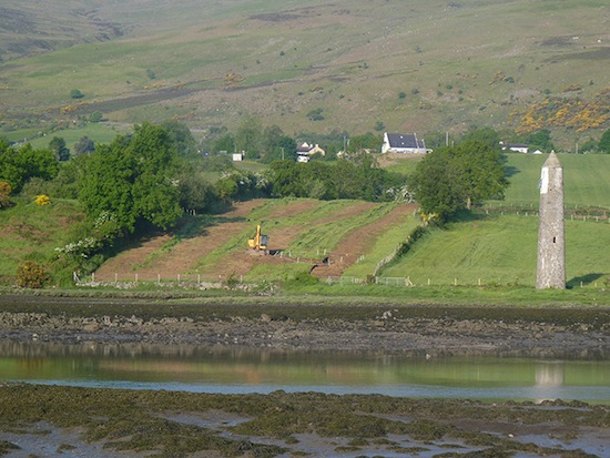 Preliminary site works underway
at Narrow Water on the County Louth side, around
6 June 2013 [Patrick McGivern]
28 May 2013: In the previous update I
mentioned the divergent opinions that surrounded
the fact that the Northern Ireland Department of
Finance had not yet approved Northern Ireland's
share of the funding. Well, today the Finance
Minister finally
announced that he has approved the
funding. This means that Northern Ireland will
contribute £2,691,880; Louth County Council will
provide £781,962 and the European Union INTERREG
IVA Programme will provide the remaining approx
£14,000,000. Since the project is not a DRD
scheme but has been proposed and developed by
Louth County Council, the Department of Finance
has put several conditions in place:
- Louth County Council (RoI) to be responsible
for covering all cost over-runs.
- Louth County Council (RoI) to meet all
maintenance costs once the bridge is
completed.
- Newry and Mourne District Council (NI) to
meet all operational costs (eg
opening/closing).
This was one of two outstanding issues
facing the project, the other being the legal
process of obtaining a Bridge Order in Northern
Ireland (a legal order that is required when
someone wants to build a bridge over a waterway
that is used by boats). This was put out for
public consultation at the end of April, and the
consultation ends on 4 June. There is the
possibility of a Public Inquiry, but given that
any objections would have to be made in relation
to the bridge's impact on boats, it is surely
unlikely that there could be many, so this may
not happen and may not be much of a delay. The
scheme has planning permission, and it is even
possible that Louth CoCo will take a gamble and
go ahead with the process of appointing a
contractor ahead of having the Bridge Order in
place, which would be fine as long as any actual
work does not begin north of the border until it
is in place. The bridge must be completed by
June 2015 to fulfill the terms of the EU
funding, and that would really require work to
be underway during this summer, 2013. See Newry
Times and BBC
coverage for more. Louth County Council's page
on the scheme was less than helpful when I
checked it!
1 May 2013: In the previous update I
mentioned that a Bridge Order was required for
the bridge, and this
was finally published for public
consultation last week, along with some associated
legislation to alter rights-of-way in the
river. A DRD press release explains
that the delay in doing this was due to some
late changes that were required to the design.
After reading the last sentence in my previous
update (below) a researcher at the University of
Ulster contacted me to explain why the Northern
Ireland Department of Finance needs to give the
go-ahead to the project. He said "The funding
from the Executive is because Louth and
possibly Newry and Mourne Council applied for
Interreg funding from the EU for the bridge.
One of the unusual features of Interreg
funding is that it requires contributions from
National Government. ... Interreg,
because of the nature of the work being
infrastructure or large scale research
projects requires commitment of the national
governments and this usually involves a
financial contribution. This is why for Louth
to draw down the money from the EU to build
the bridge, the Executive must commit to the
expenditure in the reports." (with thanks
to Philip Griffiths) The Department of Finance
has still not approved the project, and a wide
range of opinions have been expressed as to why
this might be (see here,
and here,
and at various times in the Assembly
yesterday). Supporters of the bridge have
even started a petition
urging a decision. The word on the street is
that a decision is likely to be announced in the
near future. The EU funding comes with a
condition that work is to be completed by 2015,
and for this to be achieved work really needs to
get underway during the summer.
25 Mar 2013: Louth County Council have
received planning permission to build this
bridge. However, there are still two obstacles
to be overcome. Firstly, according to a
press
release today, the DRD has now been asked
by Louth County Council for a Bridge Order. A
Bridge Order is required when someone wants to
build a bridge over a waterway that is used by
boats ("navigable"), and is designed to prevent
a situation where a poor bridge design blocks
boats from passing. As required by law, the DRD
will put this out for a public consultation
during April, and this will last for 6 weeks. If
there are a large number of objections they may
be forced to hold a public inquiry, but given
that the bridge will be of a "lifting" design,
it seems unlikely that there could be many
objections to the Bridge Order so this may not
be necessary. The need for this might scupper
Louth County Council's hope to have work
underway by the start of July. Secondly,
it seems that the bridge does require the
approval of the Department of Finance at
Stormont, due to the need for Northern Ireland
to contribute approximately £2.8m to the scheme
(source).
I am not sure exactly what this money is needed
for but it seems that it still has to get the
official go-ahead from the Department of
Finance, and that that has not yet been
forthcoming. With thanks to Patrick McGivern for
keeping me updated.
11 Feb 2013: According to a Question
for Written Answer, Roads Service does not
intend to adopt the part of Narrow Water Bridge
and its link roads that lie in Northern Ireland.
"Adopting" is the formal process whereby Roads
Service agree to be responsible for the
maintenance of a road. Almost all public roads
in Northern Ireland have been adopted, and new
housing estates are usually adopted after a
period of time, so this decision would be
unusual. Instead, the road and bridge will be
maintained by Newry & Mourne District
Council, as part of an agreement with Louth
County Council. It perhaps reflects the very
unusual cross-border nature and the fact that
the origin of the project is in county Louth.
20 Nov 2012: According to an article in
the Newry Reporter on 14th November (I only saw
a paper copy) Louth County Council have given
the timetable for this scheme as follows:
- 15 Nov 2012 - "Pre-Qualification"
questionnaire to be advertised (to shortlist
contractors)
- 17 Dec 2012 - Closure of Pre-Qualification
questionnaire.
- By Christmas - Shortlist of five contractors
finalised.
- Mid January 2013 - Final design of bridge
allows main tender process to begin.
- Mid April 2013 - Closure of tender process.
- 15 June 2013 - Appointment of contractor
- 1 July 2013 - Work to begin, to last 21
months, hence:
- April 2015 - Completion due.
In other news, a video flythrough of the
completed bridge is available here
on YouTube. With many thanks to Patrick
McGivern for sending me both these snippets.
24 Oct 2012: Today it
was announced that Louth County Council
have been successful in their
application for Special EU Projects funding of
€17.4m (£14.1m) to cover the cost of the bridge
(earlier than I anticipated last week). The
exact source of EU funds is Interreg
IVa which gives money to areas with social
and economic problems caused by the presence of
borders. This was the final hurdle for this
scheme, since planning approval has already been
granted, so I would anticipate a tendering
process will commence in the near future. Since
this fund requires projects to be completed by
2015, I would not be surprised if work was
underway by mid 2013. I have hence moved this
scheme up to "schemes likely to commence in the
next 12 months". Not bad progress for a scheme I
declared dead in July 2011!! Great news for the
regions it will serve.
15 Oct 2012:
As stated back in March's update (see below),
Louth County Council applied for planning
permission for this bridge in both Northern
Ireland and the Republic of Ireland seven months
ago. This was granted
in Northern Ireland on 12 October, and was
granted
in the Republic of Ireland on 15 October.
This does not mean that work can begin - Louth
County Council is depending upon an application
they have made for Special EU Projects funding
to cover the €18m (£14.5m) cost of the bridge, a
decision on which is due to be taken around
December this year. One caveat is that any
scheme supported by these funds must be
completed by 2015. This means that, if the
scheme does go ahead, work is likely to start
very quickly. Northern Ireland is not
contributing funds to the scheme. For those who
are interested, a vast array of technical
schematics, plans and other documents are
available on the Planning Service web site: click
here and then click on "Associated
Documents". With thanks to Patrick McGivern for
information for this update.
6 April 2012:
In a Written
Answer in the Assembly two weeks ago the
"Roads" Minister confirmed that Roads Service is
"not in a
position to contribute any funds to the Narrow
Water Bridge scheme" because "the proposed
bridge [does] not improve or extend Northern
Ireland’s Strategic Road Network, [and] it
would therefore not attract a high priority
compared to other schemes". This is not
new news, but it does spell out his position
unambiguously. The Environment Minister
(responsible for planning permission) was also
asked about the scheme. He gave a positive
response: "Planning
are fully aware of the social and economic
benefits that would follow from the
development of the bridge and these will be
taken into consideration in the decision
making process, along with the other normal
planning and environmental criteria. I recognise that
the Mournes and wider area is a wonderful
natural asset which should be protected and
positively developed. The Bridge Project is an
important application and Planning will very
carefully consider the proposal." This
suggests that the scheme is likely to obtain
planning permission. Louth County Council
applied for this about a month ago (see previous
update).
3 Mar 2012:
According to this
news story, Louth County Council has now
applied for planning permission from the
authorities in Northern Ireland for the bridge,
and also published the necessary compulsory
purchase order to acquire the necessary
land on the Republic's side of the border. There
is still no confirmation of where the money
(quoted as €20m in the article) will come from.
In the article, Louth CoCo imply that their main
hope is Interreg
funding, and that since this comes with a
limited timeframe, the scheme must be "good to
go" in anticipation of a positive result. With
thanks once again to Patrick, and also to Brian
of Old
Warrenpoint.
16 Jan 2012: It seems that this project might
get resurrected, despite the Irish
government deciding not to proceed with the
scheme last summer (see previous update).
According to this
news story in The Argus from last
month, the scheme has now been taken up by
Louth County Council. While it is true that
Louth CoCo were already spearheading the
project, previously it was to be funded
centrally by the NRA. It now seems that
Louth CoCo have basically been told that
they can still proceed with the scheme, but
only if they can come up with the bulk of
the cash by themselves. Hence Transport
minister Leo Varadkar has told Louth CoCo
that they can go ahead and apply for
planning approval, and that if they can come
up with the bulk of the cash, the NRA will
likely stump up a €1.5m contribution. The
last cost estimate of the Irish government
contribution was €14m in 2007, but it is not
known whether this is still valid given the
amount of planning that has gone on since
then. (It has always been hinted that
Northern Ireland might part-pay for the
bridge, but this has never been officially
stated.) So basically now Louth CoCo will
embark on a process of applying to all and
sundry for funding, while simultaneously
advancing the planning process. Due to this
change I am shifting this scheme back out of
"Cancelled Schemes" and into "Schemes
proposed but with no definite go-ahead",
which seems to be a fairer description of
its status. With thanks to Patrick for this
information.
14 July 2011: According to a
Written
Answer in the Irish Dáil, the Irish
government has decided not proceed with the
plan. Transport minister Leo Varadkar said: "Louth
County Council submitted an economic appraisal
and the completed Environmental Impact
Assessment of the proposed Narrow Water Bridge
project to the National Roads Authority (NRA).
These reports were reviewed by NRA on behalf
of my Department and the NRA recently
submitted their report with recommendations in
relation to this project. I have examined this
report and recommendations and based on the
economic appraisal, the current financial
circumstances, competing demands from other
local authorities for strategic schemes which
have a better benefit/cost ratio, this
Department is not in a position to
proceed any further with the Narrow Water
Bridge project, and beyond 2011 no further
funding will be made available for it."
This seems fairly definite, and doesn't appear
to be a simple postponement. It reads as if the
Minister has looked at the economic appraisal
and decided that the bridge is not worth
building. It seems almost impossible to conceive
of Stormont stumping up the cash to make up the
shortfall. Of course, any scheme can get
resurrected at any point, but in the absence of
anything official suggesting an intention to go
ahead I have moved this scheme to the "cancelled
schemes" list. This will, of course, be very
disappointing for the people of south Down and
Carlingford areas. With special thanks to Slugger
O'Toole for spotting this one and breaking
the news on his web site, and also to Andrew
Gallagher for sending me the link.
1 May 2011:
It has been two and a half years after the
previous update, and at last there is real
evidence that work is progressing. Over the past
couple of weeks a platform has been in place at
the site of the bridge which, according to Louth
County Council, is "working on ground
investigations before finalising the design"
(Newry Reporter 28 Apr 2011). There is still no
official go-ahead for construction which,
according to the council, has "no exact
timeline". The picture below shows the
platform. With thanks to Pat McGivern and Billy
Walker.
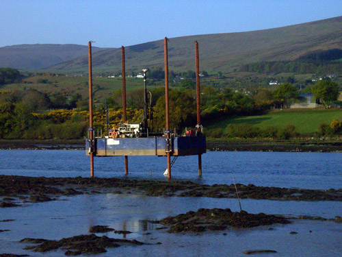
The
engineering platform being used for site
investigations
at Narrow Water, as seen on 28 April 2011. [Pat
McGivern]
21 Oct 2008: The latest
public consultation happened yesterday. The
planners have decided on the orange route
connecting directly to the existing roundabout
on the A2 Warrenpoint Road. The planners also
released pictures of the proposed bridge - see
above.
24 May 2008:
Louth County Council, who are in charge of these
early stages of the scheme, held public
consultations on 19 and 20 May. The feasibility
study is now over, and has concluded that the
scheme is viable. The next stage is to look at
the engineering issues around the scheme and to
that end three possible locations for the bridge
were proposed - as shown above. A further public
consultation is expected in August.
|