|
|
Status
|
Construction scheme
(future) |
|
Where
|
To
connect the A1 Newry Bypass directly to
the A2 Warrenpoint Road, around the
south side of the city |
|
Total
Length
|
Approx 1.5 miles /
2.4km depending on route chosen |
|
Dates
|
Included in draft
"Banbridge Newry & Mourne Area Plan
2015" - August 2006
Feasibility study
published - August 2009
Scheme moved to
forward planning schedule - 28 November
2014
Consultant appointed to produce Stage 1
Report - March 2015
Stage 1 Scheme
Assessment Report published - 15 June
2017
Public consultation
held - 14 & 15 November 2017
Preferred route
announced - 3 October 2018
Statutory Orders to be published
(presumably in draft form) - 2019 (as of
Jan 2017)
Given a funding commitment as part of
the Belfast City Deal - 2018
Belfast Region City
Deal signed (which provides funding) -
Dec 2021
Draft legal orders and Environmental
Statement due to be published - early
2024
Public inquiry likely
to happen - date not yet known
Earliest possible commencement of
construction - 2028 (as of Aug 2023;
changed from 2025-27 as of May 2021;
2023-25 as of Oct 2020)
|
|
Cost
|
£110m to £130m - as of
Jan 2025
(£85-100m - as of 2018;
£78-128m as of 2017; £100-211m as of
2009)
£93.4m of cost to be funded from the
2021 Belfast Region City Deal
|
|
Photos
|
None as yet -
please contact me if you have any to
contribute. |
|
See
Also
|
General
area map - Google Maps
A1
Newry Bypass scheme - on this site
A2
Warrenpoint Road - on this site
Banbridge
Newry & Mourne Area Plan 2015
- Planning Service
|
Click
here to jump straight down to updates
for this scheme.
The arterial A1 runs around the western side of
Newry city. Another dual-carriageway, the A2
Warrenpoint Road, runs east to Warrenpoint
harbour from Newry. However, despite being only
a mile apart, on opposite banks of the river,
the only way to go between them is to drive
right into the centre of the city. Local
politicians have long called for a southern
relief road to link them up, and this proposal
was included in the draft "Banbridge Newry &
Mourne Area Plan 2015" published in August 2006,
along with a suggested route corridor. A
feasibility study was published in August 2009
which found that the road should be built, but
also noted the proposed route was not an
efficient or easy one and suggested three other
routes which were both cheaper and easier to
build. A Stage 1 assessment report was published
in 2017 and suggested three routes for further
study. The preferred route was announced in
2018.
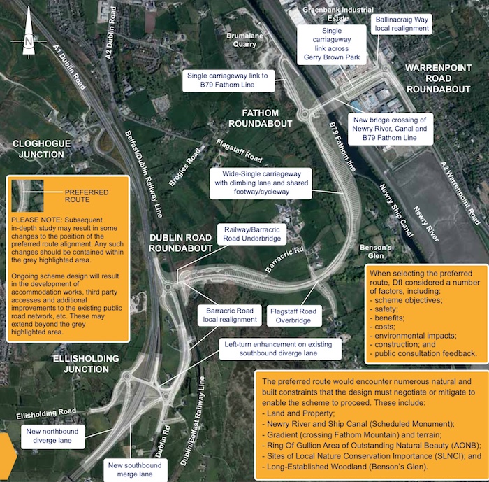
Route
The graphic below shows the proposed route as
of June 2019.
The 2017 Stage 1 Scheme Assessment Report
suggested three possible corridors - known as 4A
(red), 4B (orange) and 5 (purple). Routes 4A and
4B are identical except for the location of the
bridge over the Newry River.
Previous Proposals
The 2009 Feasibility
Report did not carry out an extensive study into
routes, but did note that the original "blue"
route proposed in 2006 (estimated cost 2009
£178-186m) "includes some significant
challenges, including proximity to the
existing Dromalane Quarry and the provision of
suitable access arrangements onto the A1...".
They proposed three further routes:
- The Greenbank Corridor,
which ran from either the
Ellisholding Road junction on the A1 or
the Cloghogue junction on the A1 and ran north
east to the existing roundabout on the A2
quite close to the city centre. Estimated cost
in 2009 was £104-124m.
- The Low-Medium Level Corridor,
which ran from Ellisholding Road junction on
the A1 south-east across a low-level bridge to
the A2 Warrenpoint Road. Estimated cost in
2009 was £100-132m.
- The High Level Corridor,
which was similar to the Low-Medium Level
Corridor except that the bridge was higher
above water level and swung inland to return
to ground level. Estimated cost in 2009 was
£211m, the most expensive of the three.
All three of these
options would have required the addition of
south-facing sliproads at the existing
Ellisholding Road grade separated junction on
the A1.
Updates
7 Jun 2026: In a question
for Written Answer, DFI Minister Liz
Kimmins confirmed that so far £8.7m has been
spent on this scheme (to the end of 2025/26
financial year) which includes £7.9m of
development expenditure and £0.8m of land costs.
A reminder that the scheme is currently on hold
pending the outcome of DFI's appeal to the A5
court ruling.
4 Mar 2026: DFI has declined
to release more details about the public
consultation which closed exactly a year ago, on
the grounds that it forms part of an unfinished
document, which is true as this would be DFI's
report on the consultation. I suspect another
reason is that DFI are not in a hurry to
progress planning for this scheme because it is
facing problems on three fronts simultaneously –
public opposition to the design of the fixed
bridge over the Newry river, the A5 court ruling
which is impacting all schemes, and the fact
that there is insufficient money to complete it.
If I worked in DFI I would probably seek to draw
out the planning process in the hope that these
pressures would have eased by the time we got to
the stage of it being ready to build, so I
suspect that's what's happening.
8 Oct 2025: In a report
to Newry, Mourne and Down District Council two
weeks ago DFI updated us on this scheme. The
public consultation which was held in February
resulted in 200 responses which DFI are
considering. Of these, 154 were objections and
of those 55% related to the decision to build a
fixed bridge over the Newry river. The overall
report discusses three major road schemes (the
other two being A1
junctions phase 2 and the A24 Ballynahinch
Bypass). However only the report on this
scheme refers to the court ruling against the A5
project under the Climate Change Act that
happened in the summer. They say "Department
officials are currently working through the
judgement, however, it is too soon to conclude
on the implications to other infrastructure
projects, such as Newry Southern Relief Road".
This may because the formal decision to proceed
has already been taken for those other schemes,
meaning that (by understanding) it's too late to
launch a legal challenge to the decision to
proceed with them. The report also says
(unsurprisingly) that a pubic inquiry will
almost certainly be held, though no timescale is
given. It should also again be noted that the
scheme has a funding shortfall (according
to the Minister Liz Kimmins) of £22 million,
since the current estimated cost is £110-130m
but only £93.4m allocated from the Belfast
Region City Deal. So if this scheme is going to
happen money will have to come from somewhere,
and at this point the only place I could see it
coming from is funding from the delayed A5
scheme. However that's an Executive decision
that's not within the remit of the DFI Minister
to decide alone. So as of now the project has
the wind against it with constraints resulting
from (a) public opposition to the bridge design
(b) climate considerations and (c) funding
pressures.
12 Feb 2025: As announced, the public
consultation to the scheme is now open, viewable
at Newry Leisure Centre on Cecil Street until 4
March. The Environmental Impact reports and
draft legal orders for the scheme - which are
BIG - are accessible online here.
These include copies of the displays visible at
the exhibition, maps showing the route of the
planned road, the land to be vested and
information on the impact on shipping on the
river and canal. Members of the public have
until 4 March to give their opinion, which will
probably next be subject of a public inquiry.
You can email comments directly to southern.sri@infrastructure-ni.gov.uk
13 Jan 2025: The autumn public
consultation mentioned in September didn't
happen after all. However, DFI announced ten
days ago that it would take place from Tuesday
21 January at Newry Leisure Centre on Cecil
Street. It will be there until 4 March and
during this six week period anyone can make a
response to the proposals (details
here). The purpose of the exhibition is to
formally set out the legal documents described
in the previous update (below). The process will
probably lead to a public inquiry later this
year. The press release also sets out the
estimated cost as £110-130m. This is
considerably higher than the £85-100m figure
that was given in 2018, and reflects the
substantial rate of construction inflation over
the past five years. This also confirms that the
cost now exceeds the £93.4m allocated from the
Belfast Region City Deal, which means DFI will
need to find additional cash to complete the
project. This may be one of the reasons the
Minister is so reluctant to increase the cost by
a further £10m by agreeing to a lifting bridge
over the Newry Canal, rather than the planned
fixed bridge.
29 Sep 2024: In a report
to Newry, Mourne and Down District Council last
week, DFI stated that they are almost ready
publish the draft legal documents and the draft
Environmental Impact Assessment Report (EIAR)
for this scheme. The legal documents are the
Direction Order (which gives DFI the right to
build a new trunk road) and the Vesting Order
(which transfers ownership of the required land
to DFI). The EIAR is essentially DFI's
justification for building the road. These will
be put out to a public consultation in "autumn
2024" (so anytime in the next nine weeks). If a
public inquiry is needed (and given the
controversy of the bridge, this is a virtual
certainty) then that would be the next stage of
the process, perhaps in late 2025. This scheme
is due to be funded by Belfast Region City Deal
which, thankfully, does not seem to have been
"paused" by the UK government as two others have
been. This at least means that the scheme
probably won't have to sit for years awaiting a
funding allocation once planning is completed.
8 May 2024: The main point of
conversation about this road has been the
decision by DFI civil servants in 2023 (when
there was no Executive) to build a fixed bridge
over the Newry Canal, which will block tall
ships from passing under. In March, once the new
Assembly was up and running, the DFI Minister announced
that he was going to "review the decision
taken... to have a 50m span fixed
bridge over the Newry Ship Canal". At the
end of April he gave his response
– "I have now completed this review and can
confirm that the decision for a 50m span fixed
bridge remains unchanged.". DFI have said
that an opening bridge would cost an extra £10m
and also that having a shorter span (which would
be needed to have an opening section) "adversely
impacts on the scheduled monument of Newry
Canal". The Minister also said that
changing the plans at this stage would take
extra time and he is keen to get the road built.
My feeling is that the first reason is more
likely to be the clincher, as the scheme is
funded by the City Deal so in the current
economic climate adding the cost of a lifting
bridge could well be enough to kill the entire
scheme through a funding shortfall. With a
public inquiry yet to happen, however, I'd
expect this debate to rumble on for some time
yet.
6 Oct 2023: DFI Roads are going to be holding
a public exhibition about the current
status of the scheme later this month. The event
is likely to be dominated by the decision (March
2023) to build a fixed low-level bridge over the
Newry Canal. This has met local opposition due
to the fact that it will block access to tall
ships reaching Newry. DFI's position is
restricted by the fact that the budget for the
scheme is largely fixed by the City Deal
funding, meaning that the scheme has
insufficient funds to include a lifting bridge.
So this event is a good opportunity for locals
to express their views and also understand the
various limitations on the scheme. Lack of an
Executive seriously hinders any effort to
acquire more funds for the scheme. More funds
may even be necessary without a change to the
design, due to construction inflation, so the
whole situation is a bit of a headache for civil
servants. Anyway, you can go and see the
exhibition at Newry Leisure Centre on Cecil
Street from 10am-8pm from Monday 16 to Thursday
19 October. However, DFI staff will only be
present on the Thursday so if you want to engage
with DFI staff you will need to go on that day.
If you can't make the exhibition, but still want
to provide your views, see the bottom
of the press release.
18 Aug 2023: DFI Roads this week released
a document showing how the current roads
programme will be prioritised in the current
economic and legislative climate, where DFI is
now required to de-carbonise transport. The
Newry SRR has remained on the current programme,
principally because it has a confirmed funding
allocation of £93.4m from the Belfast Region
City Deal. This funding is only sufficient to
build a fixed bridge over the Newry Canal, so if
the local pressure to build a moveable pressure
was to result in a design change, new funding
would need to be identified in order to proceed.
The next stage is the publication of draft legal
documents (needed to build a new road and
bridge) and an Environmental Statement (setting
out DFI's justification for the road). These are
expected in "early" 2024. These would be put out
for public consultation and would almost
certainly then lead to a public inquiry, a
process which can take maybe 18 months. This
would be followed by DFI taking time to consider
the outcome and, if approved, would then lead to
a procurement process of perhaps a year.
Therefore, as DFI state, the earliest possible
start year for construction would be 2028. (As
an aside, it has occurred to me that providing
this new road link from the A1 at Ellisholding
Road to the A2 Warrenpoint Road would remove one
of the last arguments against giving the Newry
Bypass motorway status to mirror its extension
in the Republic of Ireland. The lack of a
reasonable quality route for non-motorway
traffic from Newry to the old Dublin Road at
Ellisholding Road was previously given as an
argument against doing this. This new road would
create such a link that entirely uses A-class
roads. The Newry Bypass was otherwise built to
full motorway standard, so why not? Food for
thought.)
28 Apr 2023: Newry.ie, a Newry-based
social enterprise, has published an interesting
piece which explores what has been going
on between the council and DFI about the
question of a fixed versus moving bridge to
carry the NSRR over the Newry Canal. In early
March DFI decided to go with the "fixed" option.
The piece in Newry.ie suggests that more has
been going on behind the scenes to inform this
decision, namely that the council's own
consultants may have recommended that in the
future tall ships should be accommodated
downstream at Warrenpoint, while the Albert
Basin in Newry would be reserved for smaller
craft without masts. That's ultimately a matter
for the council to decide, but if so it does
render the design of the nearby Narrow
Water Bridge somewhat redundant if there
is no longer a plan to allow tall ships to sail
to Newry. Narrow Water Bridge is to be built
with an opening section. Construction on that
bridge is due to begin within the next twelve
months. With thanks to Patrick McGivern for the
heads-up.
10 Mar 2023: DFI published a press
release last week stating that they had
decided to adopt a non-opening bridge for the
crossing of the Newry canal and river on this
scheme - see images below. This will be a
controversial choice, given that local opinion
has been generally in favour of an opening
bridge that would not impede tall ships coming
up to Newry, and given that the Narrow Water
Bridge which is to be built a few miles
downstream will be an opening bridge. The
proposed bridge would have a clearance of 12
metres. The decision is not final (this is a
“preferred” option) as the scheme would still
need to go through a public inquiry where all of
this would be aired.
The press release notes that (as we already
knew) the project has a funding allocation from
the Belfast City Deal of £93.4m. Given that the
moveable bridge has an additional whole-life
cost of £18-32m over and above the cost of a
fixed bridge, I think this funding source
explains their preference for a fixed bridge.
The funding allocated isn’t sufficient for a
moveable bridge. The economic case for the fixed
bridge is pretty solid, but it could be that
public opinion regards other considerations to
have weight too. The only way a moveable bridge
can be built is if “someone else” provides the
additional funding. The obvious source would be
the Department for Infrastructure, which would
require the approval of both a local
Infrastructure Minister and a local Executive.
So a return to power-sharing seems to me to be
the only way that a moveable bridge will be
provided. This announcement came unexpectedly
during the week that the new UK-EU agreement on
the Northern Ireland Protocol was announced, and
I can’t help but wonder if they are linked,
especially given how much the “non-opening”
aspect of the choice was emphasised in the press
release. Is it perhaps an attempt to give local
politicians a reason to get back into
government? Who knows.
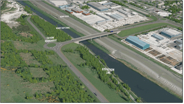
DFI mockup of the proposed Southern Relief Road
(foreground) and a fixed bridge over the Newry
canal and river.
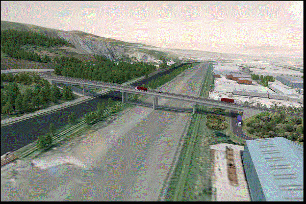
DFI mockup of how the bridge would look in
closeup. With a 12 metre clearance it would
still be a tall structure.
10 Aug 2022: DFI recently published
the "first day briefing" that was given to the
DFI Minister John O'Dowd when he entered his
post in May 2022. The briefing for this scheme
focuses on the controversy about the fixed vs
lifting bridge over the Newry river (see
previous update). It notes that the additional
whole-life cost of a moveable bridge (60 years)
would be £18-32m. In contrast, research
commissioned by Newry, Mourne and Down District
Council suggests that the loss to the economy of
a fixed bridge over the same timeframe would be
less than £200k. It is also worth noting that
the funding given to the road in the Belfast
Region City Deal is only sufficient for a fixed
bridge, so if a moveable bridge was chosen the
additional money required would have to be
provided by the Executive which (as well as not
currently in existence) is facing considerable
funding pressures. Economically, the case for a
fixed bridge is rock solid. It remains to be
seen whether other factors will be enough to
over-ride these facts.
13 Feb 2022: A quick update to note this
news article from January which reports
continued disagreement locally about the
preferred design of a fixed bridge over the
Newry river. Peter Maxwell, of the Inland
Waterways Association of Ireland is quoted as
saying "It has to be an opening bridge unless
you want to see [Albert] basin [in Newry]
completely naked with no boats in it at all."
James McArevey, of the Newry Maritime
Association said "We realise the road is
needed. If it does go ahead and it isn't a
lifting bridge, we would suggest a compromise
that the tall ships could be accommodated
south of the bridge." Because the scheme
has not yet had a public inquiry, and it's
virtually certain that it will, there is still
an opportunity for all of this to be aired an
examined. The outgoing DFI Minister has
previously indicated an openness to considering
different options for the bridge even at this
stage.
16 Jan 2022: The Belfast Region City
Deal was signed
on 17 December 2021. This is significant because
this is the source of the funding for the Newry
Southern Relief Road (though it hasn't actually
been provided yet), a project whose future now
seems secure. This is unusual among road schemes
which normally clear their planning hurdles before
funding is allocated for construction. The Investment
Strategy for Northern Ireland web site
still shows the procurement process to get
underway between Dec 2023 and Sep 2024, with
construction estimated to take place from March
2025 to September 2027, i.e. a construction
period of two-and-a-half years. Meanwhile, the
project is still in the planning stages with a
public inquiry likely to be needed at some
point. Given that a public inquiry process can
take a year or more to complete, it would need
to take place soon for the timescale above to be
achieved. The debate between a fixed bridge and
a moving bridge over the Newry canal is still
ongoing, but nothing further has been said about
this.
5 May 2021: Local media is reporting unease
within Newry, Mourne and Down Council about
DFI's preferred option for a fixed bridge to
carry the Newry Southern Relief Road over the
Newry Canal, on the grounds that such a bridge
would limit maritime traffic on the canal. DFI
have not committed to a particular design, with
a fixed bridge being their "preference" at this
time. A high-level bridge or a "lifting" bridge
are both options, though they would cost
substantially more than the fixed low-level
bridge. Meanwhile, the Investment
Strategy for Northern Ireland shows the
anticipated timescale for the scheme has slipped
substantially, with the tender process now
estimated to begin by December 2023, 18 months
later than was anticipated last autumn (see
previous update). This would mean construction
is now planned for the period from March 2025 to
September 2027. Given that it is being funded by
the Belfast City Deal, such a substantial
slippage implies that the funding isn't expected
to be released by the City Deal authorities for
about three years.
29 Oct 2020: At a DFI Weekly
Business Review Meeting four weeks ago, it
was noted that DFI has been instructed
(presumably by the Minister) to "prepare a
paper on options for taking forward [the]
Newry Southern Relief Road...". This ties
in with the fact that the road is to be funded
through the Belfast City Deal and suggests that
DFI is actively planning a strategy for
construction. The Investment
Strategy for Northern Ireland is still
listing the scheme as a future contract, but the
start of the tender process has slipped slightly
from "late 2021" to the quarter ending "June
2022" with construction now planned for the
period from September 2023 to December 2025.
12 Jun 2020: The DFI Minister announced
her budget
for the next year, which allocated money to the
Executive's flagship projects (A5, A6 and
Belfast Transport Hub). She followed this up
today with a press
release clarifying that she had approved
funding for the continuation of planning of
several planned road schemes, including the
Newry Southern Relief Road, which is due to be
funded from the Belfast City deal. This
indicates that work on the scheme will be
ongoing. There has been no further public
announcements on progress since December 2019
(see previous update). However, minutes
of DFI Board meeting on 16 Dec 2019, recently
published, suggest that the Department for
Communities has raised concerns about the
proposal for a fixed bridge over the Newry Canal
(rather than a high bridge or a moveable bridge
which would allow all shipping to pass
unhindered). The minutes state that "DfC had
raised an issue in relation to the
construction of a fixed bridge on this scheme
and that this may require discussion at
Permanent Secretary level." This is likely
to be one of the main points that comes up in
any future public inquiry.
7 Jan 2020: Just before Christmas DFI published
a summary of the feedback that they received at
the public exhibition of June 2019. We need to
give the caveat that the people giving feedback
constituted a self-selecting sample (i.e., they
were those most motivated to give feedback), and
therefore may or may not be representative of
more general opinions in the local area.
However, it is still worth pausing to look at.
The feedback showed that the two factors deemed
to be of greatest importance by the public were
(1) reducing traffic congestion in Newry and (2)
minimising the impact on the environment.
Interestingly, the two factors deemed to be of
least importance by the public were (1)
achieving value for money and (2) ensuring that
shipping can still pass along the Newry Canal.
The second one is relevant in that the proposed
design would involve a fixed, low-level bridge
which would prevent taller vessels passing
upstream of the bridge. DFI did clarify this by
adding that, despite coming low overall in terms
of public priority, "the navigation of the
canal was the issue most highlighted as a
barrier to support of the scheme". The
only other significant issue that emerged from
the consultation was the access arrangements for
Loughway Business Park and Greenbank Industrial
Estate. (The new road would involve re-routing
the access road that runs through the industrial
estate, potentially isolating the southern end
from the remainder.) Overall, 53% of respondents
were in favour of the scheme and 34% opposed.
The scheme received a funding commitment through
the Belfast City Deal in 2018, but this money
has yet to appear. At this point in time, the
Investment Strategy for Northern Ireland web
site estimates that the scheme will go out
to tender in late 2021, with construction to
take place in the period 2023-25. These
timescales are, however, tentative.
26 Jun 2019: DFI Roads ran a public
exhibition on this scheme today and will hold it
again tomorrow (27th) at the Sean Hollywood Arts
Centre. You can see the leaflet that was given
out here.
The purpose of the exhibition seems to be to
gauge public opinion on what would certainly be
a beneficial scheme in transport terms, but also
an expensive one (c£100m) with a lot of
challenges. DFI have actually included a
statement to this effect in the public
exhibition, which is unusual but also an
acknowledgement that the scheme will not be easy
and will have an environmental cost. For
example, it is tricky in engineering terms, will
be steep in places, will cross the Newry Canal
and will impact on an AONB, an SLNCI and an area
of woodland. DFI say:
The preferred route would encounter
numerous natural and built constraints that
the design must negotiate or mitigate to
enable the scheme to proceed. These include:
- Land and Property;
- Newry River and Ship Canal (Scheduled
Monument);
- Gradient (crossing Fathom Mountain) and
terrain;
- Ring Of Gullion Area of Outstanding
Natural Beauty (AONB); - Sites of Local Nature
Conservation Importance (SLNCI); and -
Long-Established Woodland (Benson’s Glen).
DFI will produce a benefit/cost analysis which
will likely show that the scheme would bring
economic benefits. After that, the balance of
public opinion in the Newry area, whether it is
pro- or anti- this scheme, which will probably
influence whether and how things proceed.
In terms of the design itself, I have included
a screenshot of the emerging design at the top
of this page. Beginning on the A1, south-facing
sliproads will be provided at Ellisholding Road
to match the existing north-facing sliproads and
provide full access. The road follows the old
Dublin Road for a short distance, before turning
sharply east via a roundabout. It goes straight
for a short distance, before heading steeply
down hill on a curve, which will require a
significant embankment. The steep incline means
that a climbing lane will be provided in the
uphill direction. It will then terminate at a
roundabout above Fathom Line before crossing
Fathom Line, the canal and the Newry River on a
bridge to terminate on the existing A2
Warrenpoint Road at another roundabout.
24 Mar 2019: The BBC reported
last week that one of the issues for the
proposed route of this scheme has been solved.
The terminus of the road on the A2 Warrenpoint
Road requires running through a GAA pitch (Gerry
Brown Park), and the owners have now
agreed to vacate the site. The scheme has yet to
go to a public inquiry but, if it does, one of
the controversial issues is likely to be the
clearance over the river. DFI's current plan
shows a bridge about ten metres above the river,
but the tall ships that sometimes go to the city
need 35 metres of clearance. DFI estimate that
an opening bridge is likely to add about £25m to
the cost of the £100m scheme, which would be a
substantial extra outlay. At the same time, a
fixed bridge would limit sailing on the river.
The scheme was given a funding committment as
part of Belfast's City Deal at the end of 2018.
However, the money hasn't yet been allocated and
in any case we're still a minimum of two years
away from construction due to the statutory
processes that still have to happen. This is one
of the most technically challenging schemes
undertaken in Northern Ireland in recent years,
combining steep terrain, environmentally
sensitive areas, navigable rivers, geologic
instability, woodland and highly constrained
route corridors.
6 Oct 2018: Last week DFI announced
the preferred route for this road. This follows
a public consultation 11 months ago at which
three proposed routes were present to the
public. These were routes 4A (red in the map
above), 4B (orange) and 5 (purple). Last
November I commented that route 5 (purple on the
map above) was the clear favourite as it's both
the cheapest and the most cost effective, and so
it has proved as DFI have selected route 5 as
their preferred route. So this means that, as
shown on the map above in purple, the new road
will begin on the current A1 at Ellisholding
Road - which will gain south-facing sliproads -
run along the old A1 for a short distance north
to a new roundabout, after which it will head
downhill towards the Newry River and canal
following an S-shaped route and then cross the
river on a bridge to the existing A2 Warrenpoint
Road. A short link road will connect the bridge
to the Fathom Line. DFI have pledged that "a
series of local exhibitions and information
events will be held over the coming months" so
we shall look forward to those. Assuming no
difficulties, DFI will now produce a detailed
Environmental Statement (which sets out the case
for building the road and the impact it will
have) and draft versions of the legal orders
needed. After that the normal procedure is a
public inquiry. So we're still a minimum of two
years away from having an approved scheme ready
for tendering, and at that point proceeding
further will depend on the availablility of
funding which has not currently been allocated.
A final point - choosing this route rules out
any possiblity of this scheme being combined
with the Narrow Water Bridge proposal. DFI's
preferred route makes more sense from the
viewpoint of Newry as a city than a route as far
south as Narrow Water, but does mean Narrow
Water Bridge needs to be a separate scheme.
24 May 2018: DFI have just released a copy
of a presentation that was recently given
on the progress of the scheme. It doesn't say
much that we didn't already know, but it does
provide a good summary of where we are now.
Notably, the presentation stresses that the
earliest date for commencement is 2024.
This is unusual as DFI are usually very
retiscent to quote dates (because they're nearly
always optimistic) so all I would say on that is
that I would read this as the earliest
date (fair wind etc) rather than the most likely
date. The scheme is extremely challenging from
an engineering perspective, combining almost
every possible complication including steep
inclines, geologically unstable land, old
quarries, the need to bridge a navigable river
and canal, proximity to an ASSI and an ancient
woodland, and a range of listed buildings and
ancient monuments. I also have to correct a
rather embarrassing mistake I made a year ago,
but since I sometimes point out errors made by
DFI I feel it's only fair to hold my hands up
when I do the same. In my June 2017 update below
I said that route 4B "coincides with the location
of the separate Narrow
Water Bridge proposal". I
don't know why I wrote that, because it is
nonsense! It's actually about 1km upstream of
the proposed site of Narrow Water Bridge. So
while the point still stands (ie, that option 4B
could negate the need for Narrow Water Bridge) I
was wrong to say that they were at the same
location. So sorry about that! I'll try to up my
game.
5 Nov 2017: Design work seems to be
continuing on this scheme, which had strong
backing from the former Infrastructure Minister
Chris Hazzard prior to the collapse of the
Executive earlier this year. The Scheme 1
assessmeny report was published in June and
there is now to be a
public consultation at the Sean Hollywood
Arts Centre, 1A Bank Parade, Newry, between
10.00 am and 9.00 pm on the 14 and 15 November
2017. This is likely to be a consultation on the
three route options published in June, rather
than telling us anything new. It is, however, an
opportunity for the public to have their say and
give feedback. The scheme has also recently been
given €1.35million (£1.2million) in European
Union funding through the Connecting Europe
Facility for ongoing design work. This Achilles
heel of this scheme has always been its huge
cost, but during planning the cost estimates
have actually fallen (rare for road schemes in
Northern Ireland) from £100-211m in 2009 to
£78-128m in 2017. This is likely to be because
the original routes went over extremely
challenging ground, whereas more recent work has
identified better options. At the minute Route 5
(purple on the map above) is the clear favourite
as it's both the cheapest and the most cost
effective. However, the presence nearby of the
proposed Narrow Water Bridge complicates things
as there is still the option of marrying the two
together, which could be accomplished under
Route 4B. So the question becomes - would
combining the two schemes give you a result
where (a) both schemes end up compromising their
objectives, or (b) the two schemes benefit each
other and everyone is a winner. That question
can only be settled by detailed analysis of
potential journeys so is currently open.
25 Jun 2017: The Stage 1 Scheme
Assessment Report, which has been in progress
since 2015, was published on 15 June and can be
downloaded here.
A Stage 1 assessment looks at a proposed road
scheme and examines the various routes it could
take, and concludes by narrowing it down to two
or three route corridors that are to be taken
forward for more detailed analysis. So that's
what has just happened. You may recall that in
2009 four corridors were suggested,
known as the "Greenbank", "Low-Medium" and
"High-Level" corridors, along with the original
2006 corridor. The Stage 1 analysis indicated
that the Greenbank corridor and the 2006
corridor are both geologically unstable and
hence should be rejected. The report recommended
three route corridors, known as Route 4A, Route
4B and Route 5. Possible lines for the road
within these corridors are shown on the Google
map further up this page
(though note that these are indicative only).
Routes 4A and 4B are identical except for the
location of the bridge over the Newry River.
This is important because the second (certainly
deliberately) coincides is close to the
location of the separate Narrow
Water Bridge proposal, and Route 4B
therefore presents an opportunity to "kill two
birds with the one stone" by providing Narrow
Water Bridge as part of the Newry Southern
Relief Road. At the western end, all three
routes terminate at the Ellisholding
Road junction on the A1. In all cases, the
design requires the provision of new
south-facing sliproads at this junction, which
is currently only accessible to/from the north.
The report also gives some predictions of the
construction cost and hence benefit/cost ratio
of rach route. In the case of the benefit/cost
ratio, any value above 1 means the scheme makes
economic sense, and the higher the better. The
report also looked at things like environemtnal
impact ("slight adverse" in all three cases),
impact on traffic flow, accessibility of the
South Down area and many other things not
outlined here.
Route
|
Estimated
Cost
|
Benefit/Cost
Ratio
|
4A
|
£128m
|
1.491
|
4B
|
£118m
|
1.859
|
5
|
£78m
|
2.211
|
The conclusion is that Route 5 should be
preferred because it is considerably cheaper
than either Route 4 option, and has a higher
benefit-cost benefit. However they also
recommend that Routes 4A and 4B be considered at
Stage 2. One reason to do this is the Narrow
Water Bridge project because if Route 5 were
chosen, Narrow Water Bridge may still get
built because Narrow Water so far away
from the bridge proposed for Route 5 that it
wouldn't really benefit the Omeath area, one of
the reasons Louth County Council are so keen on
it. The cost of Narrow Water is unknown, but say
it was £30m, then the true cost of Route 5 +
Narrow Water would be £108, making the total
cost of the combination fairly similar to Route
4B. There would also be a case for asking the
Irish government to make a contribution to such
a scheme if it meant TransportNI providing
Narrow Water Bridge. I would say, therefore,
that Routes 4B and 5 are both looking like good
options at this point. Work will now begin on a
Stage 2 report which will recommend a preferred
route.
28 Jan 2017: In a press
release issued on 16 January, the outgoing
DFI Minister stressed his committment to this
scheme. The nearby Narrow
Water Bridge scheme is a particularly
prominent scheme, and was listed in the 2009
"Fresh Start" Agreement, but it has ovbious
overlaps with this scheme since both involve
bridging the Newry river, albeit at different
points. So it seems that the two schemes are
being considered as a pair, and could even end
up beign combined. For now, however, they are
separate schemes. The Minister said he "has
instructed officials to take forward planning
and development work on the Newry Southern
Relief Road to allow the introduction of the
Statutory Orders by 2019". Now, the scheme
had already been moved to the forward planning
shcedule in November 2014, but the target date
of 2019 for Statutory Orders is new. The
"Statutory Orders" are initially published in
draft form and are usually subject to a public
inquiry. Once it has passed the Inquiry
(assuming it does) and is likely to get funding,
the orders are then made properly. It's unclear
from the press release which is meant, but
realistically it is more likely to be the
former. So by that reckoning we could expect a
final route to have been announced by 2019 with
a public inquiry likely to follow sometime after
that. The Achilles Heel of this project is its
huge unit cost, which is a consequence of the
very difficult terrain. Even the cheapest option
is over £100m which is very high for a road that
would only be 1.5 miles long. By comparison, the
4 mile A31
Magherafelt Bypass cost only £45m. The
cost/benefit analysis for the Newry Southern
Relief Road will thus be quite challenging. The
DFI would need to get the cost of the scheme
down as low as possible, which would mean a
low-level bridge over the Newry river.
3 May 2015: According to the minutes of
a TransportNI Board meeting held on 28 November
2014, but just
published, this scheme has been moved to
the Forward Planning Schedule (and indeed it
duly appears in the
FPS list). The significance of this change
is that schemes in the FPS are being actively
planned, whereas before now the scheme was
merely a suggestion, the only work being a
feasibility study completed in 2009. Now that it
is in the FPS it means that the planners will
look at it in more detail. This does not in
itself guarantee that it will be built, but it
does mean that it has entered a more formal
phase of planning. So the DRD have now said that
a "Stage 1 Preliminary Options Scheme
Assessment" has begun. This normally results in
a range of options with cost estimates and a
cost/benefit analysis of each one. There is no
indication of when this might be published, but
it could take a couple of years depending on the
resources allocated to the task.
23 Nov 2014: Supporters of the nearby Narrow
Water Bridge proposal have set up a web
site here
and their aim appears to be to continue to lobby
for the provision of the bridge, whose
construction fell through this time last year
due to inaccurate cost estimates. The text on
the main page implies that they are suggesting
that that scheme be combined with the Southern
Relief Road. The idea may be that the Southern
Relief Road could start on the A1 further south
than currently planned, close to the RoI border,
and then cross the Newry River at Narrow Water
via the proposed Narrow Water Bridge. This would
require a short stretch of the road to be
located in County Louth, so it would introduce a
cross-border element. The expense of this scheme
as it currently stands (anywhere from
£100m-£211m) means that it is a low priority for
the DRD, but this idea of linking it to Narrow
Water and using a more southerly approach route
is certainly worth looking into since it would
require only one bridge to be built to achieve
the aims of both proposals. With thanks to Paul
Sloan for letting me know about the new web
site.
22 April 2012:
The Minister was asked about progress on this
scheme via three Questions
for Written Answer in the Assembly two
weeks ago. He said that Roads Service are
currently "undertaking
further environmental and engineering
assessments" and that this work will be
completed in mid/late 2012. He added that this
would inform the selection of the preferred
route, but it sounds as if this could be after
the date mentioned. He confirmed that so far
Roads Service have spent just under £930,000 on
planning for this scheme. However, he also
stressed that the scheme has not, and never has
been, given a definite go ahead, and that
therefore there is no timescale for
construction.
26 Sep 2009: The Feasibility
Report into the scheme was published in August
2009, and
a press release issued five days ago. The
report showed significant benefits to proceeding
with the scheme and proposed four alternative
route corridors. The report however recommended
against the route proposed in 2006, for cost and
engineering reasons, instead suggesting three
alternatives as shown on the map above. The cost
estimates vary widely from £100m to £211m
depending on the option chosen. On the basis of
the report the Regional Development Minister has
"asked Roads Service to proceed with further
environmental and engineering assessments and
to engage in a wider consultation process,
considered necessary to identify a preferred
corridor for the Newry Southern Relief Road."
There are still no firm plans to proceed with
the scheme which, if it does happen, is unlikely
to happen in the near future and perhaps not for
ten years. It is also interesting to note that
the feasibility report comments that
constructing this scheme, at least if the
Low-Medium Level Corridor is chosen, could
render the proposed Narrow
Water Bridge project redundant.
23
May 2009: According to the Minister
of Regional Development (during a question
and answer session in Stormont a couple of
weeks ago) the feasibility study into the Newry
Southern Relief Road has now been completed, but
Roads Service want to do additional work
"developing its findings" before releasing it
publicly. He said "The project is important.
Roads Service and the consultants it has
engaged have undertaken significant assessment
work." and "We hope to be in a
position to present the report’s findings
soon". The first of these comments
suggests that the feasibility study was
favourable towards the road's construction, but
we shall have to wait and see.
|