|
|
Status
|
Construction scheme
(completed) |
|
Where
|
To add
new bus lanes, cycle lanes and
pedestrian crossings in Belfast City
Centre by reducing road space for
general traffic, and creating a new
one-way gyratory west of the city
centre.
|
|
Total
Length
|
Includes 2.6km of
bus lanes and 1.3km of cycle lanes
|
|
Dates
|
Proposed as part of
"Belfast on the Move" scheme - 30 Sep
2010
Public consultation Oct and Nov 2010
First bus lane came into operation - 21
Nov 2011
Hope Street & Durham Street schemes
began - 6 Jan 2012
Hope Street scheme
completed but unopened - May 2012
Oxford St bus lanes - 5 July 2012
May St / Donegall Sq South / Howard St
bus lanes - 17 Sep 2012
Hope Street became two-way - 28 Oct 2012
Phase 2 of works resumed - 28 Jan 2013
College Square East / Avenue bus lanes -
12 Apr 2013
Great Victoria Street bus lane - 26
April 2013
Wellington Place / Donegall Sq North /
Chichester St bus lane - 31 May 2013
Most STEM works
completed early June 2013
Final component (Ann
Street cycle lane) completed October
2013
Final infrastructure to be completed
during summer 2013
|
|
Cost
|
£4.2m (£2.5m in
2012 and £1.7m in 2013 |
|
Photos
|
See below |
|
See
Also
|
Original
Sep 2010 press release - DRD
Map
of proposals - DRD (PDF)
Official
web site for Belfast On the Move
- DRD
Belfast
Rapid Transit System - on this
site
1.
Streets Ahead Enabling Measures
Phase 1 - on this site
3.
Rapid Transit Enabling Measures
- on this site
4.
City Centre Ring Road Southern
Section - on this site
5.
Streets Ahead Enabling Measures
Phase 2 - on this site
6.
Transforming the City Centre Ring
Road - on this site
|
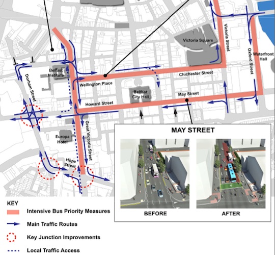
Belfast is currently undertaking a long-term
scheme to redirect general traffic flows out of
Belfast city centre, in order to permit a greater
role for buses, rapid transit, pedestrians and
cycling. Called Belfast
on the Move, the work is being carried
out in six phases, of which this scheme is the
second (Phase 1 was completed in 2011 - see links
above):
- Streets Ahead Enabling Measures Phase 1
- Sustainable
Transport Enabling Measures (STEM)
- Rapid Transit Enabling Measures
- City Centre Ring Road Southern Section
- Streets Ahead Enabling Measures Phase 2
- Transforming the City Centre Ring Road
Phase 2 involves taking road space away from
general traffic and using it to provide new bus
and cycle lanes. In some cases, the capacity of
the road for general traffic is being reduced
from four to two lanes. To the west of the city
centre a one-way system is being introduced to
take traffic off Great Victoria Street to enable
greater bus priority. The proposals are too
detailed to describe in text, but a summary is
as follows:
- 2.6km of new bus lanes throughout the city
centre.
- 1.3 km of dedicated cycle lanes in the city
centre.
- 20 new signalised pedestrian crossings and
40 disabled parking spaces.
Creation of a clockwise gyratory on
College Square East -> Grosvenor Road
-> Durham Street -> College Street.
Deleted from plan as of January 2013.
- To make Hope Street two-way, to
facilitate...
- Great Victoria Street to become one-way
southbound.
Much more precise proposals can be seen on page
2 of this
PDF file (but this file is out of date
as of Jan 2013). The entire process is due
to be carried out from late 2011 to mid 2013.
The map below is an updated DRD map and
shows the major elements of the project as they
stood in January 2013. Eventually the plan is to
take all general traffic off Donegall Squares
North and South, ie from in front of and behind
City Hall.
Previous Scheme
The map below is an old DRD map from
2011 and shows the original plan which
featured a one-way system west of the city
centre. This was planned because it was throught
that Rapid Transit would use Grosvenor Road and
hence space would be needed on Grosvenor Road.
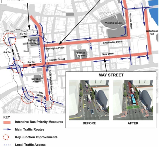
Map of proposed changes as part of the STEM
project as of 2011 [DRD from here].
Updates
23 Sep 2013:
As stated in the previous update, the final bus
lane came into effect at the end of May. Work
over the summer has been confined mostly to the
installation of the last remaining cycle lane on
Ann Street. Ann Street is due to be resurfaced
shortly, after which it has to be left to set
for about three weeks before the new green cycle
lane surfacing can be added over it. After that,
the STEM project will be fully completed. Hence
I'm marking this scheme as being completed in
"October 2013". It is very likely that – as
planned – the next phase of the ongoing Belfast
on the Move project will be the Rapid
Transit Enabling Measures, which could
start to roll out during 2014.
26 Jun 2013:
The final bus lane of the STEM project came into
operation on 31 May 2013: across the front of
City Hall along Wellington Place, Donegall
Square North and Chichester Street. This allows
just one lane for general traffic along most of
this distance, and had the potential to the the
most disruptive of all measures. However, these
fears proved generally unfounded and the new bus
lane came into operation with much fewer
problems than were the case nine months ago when
the bus lane behind City Hall was introduced.
Congestion does seem to be a bit worse than
before on Great Victoria Street and Fisherwick
Place, but in general there was little media
attention. On social media the focus has instead
been on the rather poor enforcement of the bus
lanes in the city, including the city centre,
which is a big issue that the DRD do need to
address. All the "bus lane" elements of the STEM
project are now complete, but further works
still have to happen before final completion:
- Ann Street – introduction of a 2 way cycle
track from Victoria Street to Oxford Street;
- Linenhall Street - introduction of a 13m
loading bay and a contra flow cycle lane from
Donegall Square South to James Street South
Meanwhile, the DRD themselves have assessed the
impact of the bus lane on
their web site in these terms: "During
the initial ‘bedding in’ period for these
amended road layouts, while the travelling
public got used to the new arrangements, there
were some additional delays to vehicles
accessing the city centre. However, in the
last few months the level of congestion has
been reduced and traffic flows are improved.
Preliminary information indicates that
traffic levels are lower across the city
centre, there appears to have been no
significant impact on journey times through
the city centre and some of the ‘through’
traffic has diverted to more strategic routes.
In addition there was no decline in the
numbers of cars parking in the city centre
which shows that people are still driving into
the city to park. There is no evidence to
suggest that the changes have deterred car
borne shoppers.
Early indications from Translink are that
buses are getting through the city centre more
quickly, the services are staying on schedule
and are more reliable and their customers are
seeing real benefits. In addition the Park
& Ride facilities serving Belfast have
seen a marked increase in usage."
At this point in time, there is no reason to
think that the scheme has not been successful,
so the scheme's designers and managers deserve
credit for what has been achieved.
20 May 2013: The
Fisherwick Place bus lane came into operation
three weeks ago, and the resultant congestion
has not been as bad as feared, which is good
news. On Friday 17 May a new bus lane came
into operation on Donegall Square East (to
the left of City Hall if you're standing looking
at the front door). The main impact of this on
car drivers is that it is no longer possible
to drive straight on (across May Street) from
Donegall Square East into Adelaide Street (this
movement) during its hours of operation.
The reason is not just the creation of the bus
lane - this is a very popular way of getting
into the southern part of the city centre from
the west, and by deliberately preventing the
movement the hope on the part of the Belfast On
The Move planners is surely that drivers will
find alternative routes that avoid the streets
around City Hall, helping achieve the goal of
reducing the amount of traffic around City Hall.
Roads Service have published
a map of some suggested alternatives not
all of which, it has to be said, would appear to
support this goal. The next phase of work
will be the introduction of the new bus lane
across the front of City Hall along Wellington
Place, Donegall Square North and Chichester
Street, likely to be the most disruptive of all
the lanes introduced to date. DRD are saying
that this work will be completed by the end of
May, so its introduction must be going to take
place within the next 10 days or so. As always,
see official
STEM web site for the most up-to-date
information.
28 Apr 2013:
New bus or cycles lanes have come into operation
over the past three weeks: College Avenue bus
lane came into operation on 12th April;
Grosvenor Road cycle lane (Durham St to
Fisherwick Place) on 22nd April; and Great
Victoria Street bus lane (Hope St to Grosvenor
Road) on
26th April. None of these seemed to cause
serious problems. The next change will be a new
bus lane on Fisherwick Place which will come
into effect on 1st May. It will mean that only
one lane will be available for general traffic
turning right into Wellington Place, a very
popular movement, so this change may create
congestion. The work to create a new bus lane
across the front of City Hall along Wellington
Place, Donegall Square North and Chichester
Street must surely get underway over the next
few weeks, this being the element of the work
that is likely to create the most congestion
during the 'bedding in' period. As always, see official
STEM web site for the most up-to-date
information.
11 Apr 2013:
As I said in the last update, work on Phase 2 of
the STEM project as been ongoing for over two
months now. According to a press
release issued today, the bus lanes are
going to start going live in batches, with the
first one - the southbound bus lane on College
Avenue and College Square East going live
tomorrow, 12th April. This one has been created
by widening the road, so will not reduce the
capacity of the road for general traffic. The
press release also suggests that from 22nd
April, Grosvenor Road eastbound will be
reduced from two general traffic lanes to one
general traffic lane between Durham Street and
Fisherwick Place, with the extra space being
turned into a dedicated cycle lane. This will
create some disruption, so Roads Service want
road users to consider using Durham
Street/College Square North or Sandy Row/Hope
Street as alternatives. Finally, starting at the
end of April work will begin on the most
controversial element of them all - the
introduction of the bus lane across the front of
City Hall along Wellington Place, Donegall
Square North and Chichester Street which will be
introduced either in May or June. This change
will lead to major traffic disruption for a
number of weeks, so if you use this route it is
worth thinking now about alternative
routes or modes of transport. I have blogged
about these changes in more detail, including
maps. As always, the official
STEM web site is being kept impressively
up-to-date with information about planned road
closures, and is well worth checking
regularly.
20 Mar 2013:
Work has been progressing steadily during the
six weeks since the last update. Works are
currently concentrated on College Square East,
Fisherwick Place, Great Victoria Street and from
next week will take place (with lane closures
overnight only) on College Square North &
East, College Avenue, Durham Street and College
Street. That will take us up to Easter, and it
seems that the "major" element of the scheme, at
least from the motorist's point of view, will
then begin - the introduction of the bus lane
across the front of City Hall along Wellington
Place, Donegall Square North and Chichester
Street, along with restrictions to the use of
Donegall Square East. The whole STEM scheme is
due to be completed by mid June, which is around
12 weeks from now. Given that this will see a
fairly major reduction in capacity once it goes
live I would anticipate widespread traffic
congestion for a month or more, coupled with
significant negative media attention, in line
with what we saw in September 2012 when the bus
lane behind City Hall was introduced. However
past experience suggests that the scheme will
'bed in' over a 6-8 week period as road users
find alternative routes or modes of transport,
and I would recommend road users should allow
this much time before making a judgement of the
scheme. As I have said before, the official
STEM web site is being kept impressively
up-to-date with information about planned road
closures, and is well worth checking regularly.
11 Feb 2013:
The official
STEM web site is being kept very up to
date with information about planned road
closures, and is well worth checking regularly.
Some work has taken place on Fisherwick Place
and Howard Street, but for the next four weeks
work will be focused on Great Victoria Street,
where a northbound bus lane will eventually be
introduced. Although the work will take place
during the daytime, the lane restrictions will
be removed during the morning and evening rush
hours. Meanwhile, in a Question
for Written Answer in the Assembly, the
DRD Minister has reiterated some of the
statistics showing the initial impact of last
autumn's new bus lanes. It suggests that in the
aftermath of the bus lanes, traffic levels on
Oxford Street and May Street fell by 5000
vehicles per day, while Chichester Street fell
by 2000 vehicles per day. Meanwhile, Westlink
rose by 4000 per day. On the buses, patronage
rose by 1500 per day, and the use of
park-and-rides rose by 15%. However, these
statistics are preliminary and it will not be
possible to fully assess their impact until the
second half of 2013, when all works are
complete. The total cost is given as £4.2m.
19 Jan 2013:
The announcement
of the next phase of the STEM project took place
on Wednesday 16th January. The information
confirmed that work is going to begin on Monday
28 January, and will initially involve work on
Great Victoria Street and Grosvenor Road, before
advancing in the coming months to cover College
Avenue and finally the route along the front of
City Hall with all works due to be completed by
Summer 2013. The full list of works is as
follows:
- Great Victoria Street (Hope Street to
Grosvenor Road) and Fisherwick Place - lane
reallocation and introduction of a northbound
bus lane;
- Grosvenor Road (Durham Street to Great
Victoria Street) - lane reallocation;
- College Avenue and College Square East -
lane reallocation and introduction of a
southbound bus lane;
- Victoria Street – introduction of a cycle
track from Chichester Street to Gloucester
Street;
- Ann Street – introduction of a 2 way cycle
track from Victoria Street to Oxford Street;
- College Square North, Durham Street and
Grosvenor Road – resurfacing;
- Wellington Place, Donegall Square North,
Donegall Square East and Chichester Street -
lane reallocation and introduction of bus
lanes.
As noted in the previous update, November's
decision to shift the route of the western side
of Belfast Rapid Transit from Grosvenor Road to
Falls Road has impacted on this scheme. You can
see the changes by comparing the two maps
further up the page. Specifically it means that
Grosvenor Road no longer needs to have a bus
lane on it and therefore will have enough space
to remain two-way. This means that the
proposed one-way system around Durham
Street/College Square North is no longer
necessary and has therefore been removed
from the plan. This will save a good bit of work
in this vicinity. It also means that drivers
will be able to turn right out of Howard Street
onto Fisherwick Place and from there turn right
onto Wellington Place (as they can at present)
except that Wellington Place will be reduced to
one lane for general traffic.
DRD seem to have learned from the experience of
Phase 1, so there will be plenty of warning this
time ahead of each change to the road network
and will be publicising suggested alternative
routes (which, for people whose destination is
not in the city centre, is generally Westlink or
Outer Ring). But commuters also need to be aware
and accept that there will be disruption,
possibly on the same scale as last October, but
we do know from experience that this is very
likely to bed in within 6-8 weeks as it
did the first time round. On this final point,
DRD have made a few observations that indicate
that the scheme is actually working as planned:
- In Oct/Nov 2012 Metro passengers were up
1500/day compared to the same period in 2011.
- In Oct/Nov 2012 park-and-rise use was up 15%
compared to the same period in 2011.
- There appears to have been no reduction in
city centre parking, meaning that shoppers do
not seem to have been deterred from the city
centre.
14 Jan 2013:
The next phase of STEM, ie the works due to take
place over the next six months, are due to be
officially launched this week. There seems to be
a determination to ensure maximum publicity for
what is being proposed, which is good news. The
announcement is likely to include an adjustment
to some of the details of the plan due to the
decision made in November to route the WWAY
Rapid Transit route along the Falls Road rather
than Grosvenor Road. In particular, it would
seem to be necessary to facilitate buses turning
right onto College Square East from Howard
Street. However, I do not want to speculate
before the announcement. The Belfast Telegraph ran
an article last week where they discussed
the proposed removal of about 80 metres of the
bus lane that was introduced at the western end
of Howard Street last year (incorrectly
illustrated with a picture of the Donegall
Square South bus lane that is staying). My gut
feeling is that the removal discussed in this
article is in fact one element of a series of
changes being made to facilitate the changed
route of rapid transit, and does not in any way
indicate a backing-down by the DRD!
12 Dec 2012: In
a talk at the PLACE
Architecture and Built Environment Centre today,
Ciarán de Búrca (the head of the project)
confirmed that the entire STEM scheme should be
completed by June 2013, and that work to
implement the next round of bus lanes would
begin at the start of January. I
have also blogged once again about the new
bus lanes and how they are faring three months
on.
1 Dec 2012: On
12th December at 1pm Ciaran De Burca – the
person at DRD who is responsible for leading the
STEM project and the wider Belfast on the Move
scheme - will be outlining the objectives of the
project and taking questions. The event is being
hosted by the PLACE Architecture Centre on
Fountain Street, Belfast (near Waterstones).
Admission is free and is open to anyone, but as
space is limited you still need to get a ticket
by visiting this
web page. Queries should be directed to PLACE. I
should also have said before now that I blogged
about the new bus lanes again about two weeks
ago, discussing how things had gone in the two
months since the May St/Howard St lanes were
introduced. Finally, the DRD web site has been
updated and suggests that the next set of STEM
works in Belfast will be on Great Victoria
Street, Grosvenor Road and Fisherwick Place
early in 2013.
25 Oct 2012: Over
the past month the media interest in the new bus
lanes has dwindled greatly, and I have heard
much fewer reports recently about the
congestion. Whether this means (a) it has
"bedded in" (b) people are switching to bus or
(c) people are travelling into the city less or
(d) a combination of these, remains to be seen.
In other news, the
DRD have reported that Hope Street
will become two-way this Sunday,
28 October 2012. The work was actually carried
out in the spring of 2012, but the westbound
lanes have sat unopened for the past five
months. Hope Street will be closed from Saturday
evening to carry out the switch over. Hope
Street is a short street, but this important
change will allow Roads Service to make Great
Victoria Street one-way southbound from
Grosvenor Road to Hope Street early next year
(see map above). The works on College Avenue
are now complete (earlier than anticipated in
the last update), and Roads Service. Apparently
no further major works will be carried out
before January - this may have been in response
to the concerns of traders who are worried about
trade in the run up to Christmas. Finally, the
DRD are also saying that over the next few weeks
work will be carried out to resurface
the footpaths behind City Hall. It is not known
whether the STEM scheme is still on schedule for
completion by "mid 2013" as was advertised last
January.
2 Oct 2012:
The past fortnight has seen a flurry of media
attention devoted to this scheme due to the
apparent increase in congestion that the new May
Street-Howard Street bus lanes have been
created. I have blogged
about this. This has resulted in the DRD,
Belfast City Council and PSNI setting
up a joint working group to meet
fortnightly and tackle the congestion issues.
The DRD, for its part, is urging people to be
patient by giving the scheme plenty of time to
'bed in' before judging it. Meanwhile, work
continues on the scheme, with work underway on College
Avenue (erroneously labelled as Millfield
by Google) for the period October and November,
which will result in a new southbound bus lane.
Work is presumably also going to get underway
before too long on the one-way system on College
Square North/ College Square East / Grosvenor
Road / Durham Street (see map above). This work
ought to be completed by early 2013. I have explained
the works on College Avenue in more detail
over on my blog, since it seems to have caught
motorists by surprise.
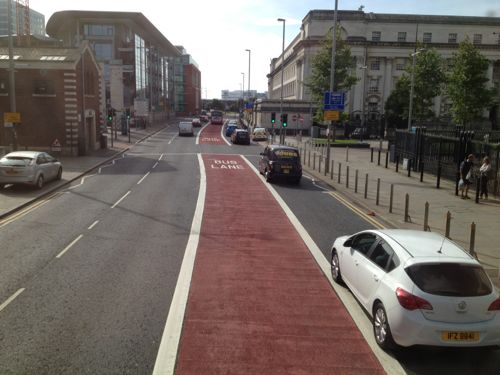
17 Sep 2012:
The new bus lane on May
Street, Donegall Square South and Howard
Street came into force this morning
(although the erroneous signage indicating the
location of the bus lane makes it uncertain
whether it is enforceable @andyboal). This bus
lane affects the main westbound route behind
City Hall, and has more impact than the Oxford
Street bus lane which opened in July, because it
reduces the number of traffic lanes for general
traffic from 4 to 2. The space freed up by this
has become an extra wide bus lane leaving enough
space for cyclists to share it (the graphic
above shows an illustration of this). The route
also features a bus gate at the Linenhall Street
junction to allow the buses to switch from the
left lane (ie, where the bus stops are) to the
right lane (to turn into Donegall Square West).
Activity in the media and on Twitter suggested
that traffic congestion was worse this morning
than normal, with knock-on delays some distance
away in places like Ravenhill Road. It will, of
course, take time for the new setup to find its
equilibrium and it's therefore unfair to judge
it straight away. The engineers appear to be
working clockwise round the city centre, so
presumably the next phase will involve work
around the area of the Great Victoria
Street/Grosvenor Road junction.
8 Sep 2012:
Progress continues apace on this scheme. The
schools going back last week coincided with
resurfacing work on May Street, and the first
time the Oxford Street bus lane was in force.
The impact was mixed, as this
article in the NewsLetter outlined.
Progress doesn't seem to be quite as good was
forecast in June (see updates below). The
resurfacing work on May Street appears to be
only just completed, while there don't appear to
be any new signs in the central area yet. The
photos below were all taken two days ago from a
bus, taken as I was exploring the new setup.
Meanwhile, I've written about the prospects for
the STEM scheme over
on my blog.
View south along Oxford Stret from Queen
Elizabeth Bridge, showing a bus going through
the new "bus gate" while red lights stop the
cars in the three general traffic lanes. The bus
gate allows the bus to get across two lanes (see
next pic). Taken 6 Sep 2012. [Wesley Johnston]
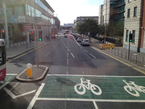
Taken from a bus which went round the bus gate
(!?) after the bus light changed to red. Clearly
showing the way the lanes ahead have changed, as
well as an advanced stop line – the first of
many cycling measures. The old lane marking sare
still visible. Taken 6 Sep 2012. [Wesley
Johnston]
View southbound on Oxford Street (about here)
showing the new bus lane. The bus lane is in
lane 3 as the two right lanes turn right onto
May Street ahead. This is part of the reason for
the bus gate behind. Taken 6 Sep 2012. [Wesley
Johnston]
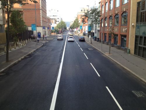
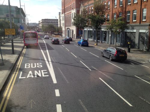
Resurfacing work underway on May Street, looking
west, with some of the road markings down. This
road was formerly 3 lanes with parking spaces on
the right. The parking spaces have been removed.
The area on the left will be a bus and cycle
lane. Taken 6 Sep 2012. [Wesley Johnston]
20 Aug 2012:
Over the summer much work has taken place. The
new bus* lane on Oxford Street came
into use on 5th July 2012. Unusually, the
bus lane is the third of the four lanes (ie
general traffic can be on either side of it, but
not in it). A bus gate has been introduced
(traffic signals that stop general traffic to
let a bus through) for both speed and to let the
bus change lanes easily. General traffic can
still use the bus lane from 7pm to 7am, and all
day on Sundays, when buses do not need to be
given priority. From keeping an eye on Twitter
and discussion forums, it's clear that the first
week or two resulted in total confusion for
drivers as they tried to work out what lane they
had to be in, but according to the DRD "the
new arrangements are now operating
satisfactorily without undue delays". The
scheme has reduced the space on Oxford Street
for general traffic by 25%, but so far this
doesn't seem to have caused problems. Another
bus lane has been introduced on East Bridge
Street. The DRD also said on their web
site on 8 August that "further bus
lanes and bus gates will be introduced in May
Street to Howard Street over the summer months
[August?], followed by further works on
Fisherwick Place culminating in bus lanes
being provided in Wellington Place to
Chichester Street in Spring 2013".
*The "bus" lane can be used by buses, permitted
taxis, motorbikes and cyclists.
24 Jun 2012: The
elements of this scheme continue to hot up. The
Hope Street scheme is now finished and work to
adjust the Durham Street / Grosvenor Road
junction is well advanced. Two weeks ago the DRD
released a
press release noting what would be
happening over the next three months:
- June 2012 - A bus lane being introduced in
Oxford Street, from Queens Bridge to May
Street, May Street, Donegall Square South and
Howard Street. (A traffic island has already
been erected on Oxford Street at the time of
writing, presumably to let buses switch from
the left lane to the right safely).
- June/July - Resurfacing of May Street,
Donegall Square South and Howard Street, prior
to the introduction of the bus lanes
by early July.
- July/August - Erecting a new strategic
direction signage
system throughout the city (presumably to
direct traffic around the new one-way gyratory
west of the city centre, and perhaps also to
direct strategic traffic away from City Hall).
In the longer term, the press release notes
that: "Over
the next year, the Department for Regional
Development’s Roads Service will be continuing
to introduce more bus and cycle lanes in the
city centre. Work will include resurfacing,
erecting signage, traffic signal installation,
kerbline alterations, pedestrian crossings and
road markings. The changes to junctions,
traffic flows and routes for Translink’s buses
will affect streets around the City Hall area".
Additionally, signage on site suggests that the
Barrack
Street 'rat run', a long time bone of
contention for residents, will be closed off as
of today. This 'rat run' became more popular
with the 2006-2009 Westlink upgrade which has
closed off access at Grosvenor Road for traffic
coming from the north.
A map
document has also just been released
showing in full detail the uses that will be
permitted at the sides of each road. All of
these changes should be in place by summer 2013,
when the STEM scheme is due to be completed.
Finally, 30th May 2012 saw the publication of
all six legal documents required to make the
STEM scheme a reality:
• The Bus Lanes (Belfast City Centre) Order (NI)
2012,
• The Cycle Routes (Amendment No.)Order (NI)
2012; and
• The Waiting Restriction (Belfast City Centre)
Order (NI) 2012.
• The Parking Places on Roads (Belfast City
Centre) Order (NI) 2012,
• The Parking Places on Roads (Coaches) Order
(NI) 2012; and
• The Control of Traffic (Belfast City Centre)
Order (NI) 2012.
1 May 2012:
The DRD posted an update
on their web site about five weeks ago,
including images, which I have only just found.
It indicates that work began on the junction
modifications of Hope Street/Great Victoria
Street on 30 January 2012, and that work began
on the modifications of the Grosvenor
Road/Durham Street junction a week earlier, on
23 January. Work at the Durham Street junction
is due to take four months, which would suggest
there is still a month of work to go here.
However, the update suggests that all the
associated works will not be completed until the
end of June.
Meanwhile, the new traffic signals at the Sandy
Row/Hope Street junction (the bottom left
junction on the map above) went live on 16 April
2012. Great Victoria Street remains two way for
now, but this will change next year – I assume
that the next part of the project will be to
modify College Square North and Durham Street
(beside Belfast Institute on the map above) as
this will also need to be completed before the
one-way gyratory can be implemented. Although
these changes may seem like tweaking, they are
part of a bigger plan and will facilitate
increased priority for buses, cyclists and
pedestrians in the central part of the city.
7 Jan 2012:
The first of the proposed bus lanes (on Victoria
Street) came into operation on 21 November 2011,
and operates from 7am to 7pm according to this
press release. Meanwhile, work on the
scheme to make Hope Street two way gets underway
in two days (on 9 January) according to this
press release. This will not only involve
converting Hope Street into a two-way road, but
also upgrading the junctions at either end of
Hope Street, and Grosvenor Road/Durham Street
junction. The work will take four months, but
the press release implies that Great Victoria
Street will remain two way at that point, only
becoming one way once the one-way system at
College Square is completed. The same press
release implies that all of the STEM works are
due to be completed over the next 18 months, ie
by mid 2013.
|
