|
|||||||||||||||||||||||||||||||||||||||||||||||||||||||||||||||||||||||||||||||||||||||||||||||||||||
|
|
A12 Westlink, Belfast
The A12 Westlink is an incalculably important road, connecting the M1 to the south of Belfast to the M2 and M3 to the north. Second only to the M2 in terms of traffic levels, it is one of the busiest roads in Northern Ireland, carrying about 70,000 vehicles per day in 2004. As well as tens of thousands of daily commuters, virtually all traffic heading to Belfast Port from the south travels along the Westlink. Drivers have a love-hate relationship with this road which has been chronically congested since the day it opened in 1981, yet serves as a vital artery to the growing city. History | Junction Map | Construction Timeline | Route Description Traffic Data | Future Plans | Original Map | Photographs | Historic Photographs A detailed history of the original concept of the Westlink, and how it evolved into the road we know today, can be found on the Belfast Urban Motorway page. Suffice to say, what eventually got built was far removed from the original plans for an elevated motorway encircling Belfast city centre. By the time it was completed in 1983, the original plans had been reduced to a dual two-lane road, the northern half grade-separated with flyovers, and the southern half at-grade with roundabouts and traffic lights. A complex project carried out from 2006 to 2008 saw the southern section grade separated and widened to dual three lanes. Compulsory variable speed limits were introduced on the Westlink on 16 September 2010 in an effort to further control traffic flow and limit congestion.
Beginning at the north end the A12 Westlink starts at a traffic light controlled junction with York Street north of the city centre. This junction connects to the M2 and M3 as well as the local road network. To increase the capacity of the junction, the A12 is three lanes wide at this point, but the third lane is quickly merges with the second as the road climbs up steeply to cross over North Queen Street on a bridge. The road is therefore two lanes each way from this point. As the surrounding land continues to slope upwards, the Westlink levels off and then descends below ground level to pass beneath Clifton Street (the bottom of the Crumlin Road). At this point there is a junction with four sliproads giving full access to and from the Westlink. After climbing a little the Westlink drops a second time to pass beneath Peter's Hill (the lower Shankill), but with no access. This whole stretch is known as the "canyon" section since it is contained within a vertically-sided cutting and dates from the road's construction in the early 1980s. The road climbs up again before descending for a third time to pass beneath Divis Street (the lower Falls). There are four sliproads at Divis Street giving full access to and from the Westlink. The layout of Divis Street junction is remarkable since it is a single-point urban interchange, the only example of this type of junction in the entire UK. The north-facing sliproads at Divis Street and the south-facing sliproads at Clifton Street have incredibly short merges, meaning that traffic on the Westlink is usually forced to give way to traffic joining from the sliproads. The south-facing sliproads at Divis Street continue as additional lanes, so from this point onwards the Westlink is three lanes each way. The Westlink then descends yet again - but not as deep as before - to pass beneath Grosvenor Road. The Grosvenor Road rises above ground level to cross the underpass which is only about 4 metres below ground level. This underpass is newer, having opened in 2007. Due to its proximity to Divis Street junction, there are only two sliproads giving access to Grosvenor Road, and these are on the south side of the road. The Westlink then makes a very sharp turn to the right, one that can be tricky to negotiate at the 50mph speed limit. On the northbound side of the Westlink there is a left-in/left-out access road (Mulhouse Road) leading into the grounds of the Royal Victoria Hospital. This cannot be accessed travelling southbound. Opposite Mulhouse Road a bus-only lane from the Europa Bus Centre merges with the Westlink. The inbound bus lane runs adjacent to the east side of the Westlink from Broadway roundabout to this location. Passing beneath the distinctive tubular Roden Street footbridge, the Westlink curves to the left, travelling at ground level. It then descends down below ground level for a final time to pass beneath Broadway roundabout. As it starts its descent the road becomes the M1 motorway: our journey along the Westlink is completed. At off-peak times our journey should have taken around two minutes. Traffic levels on selected sections of the Westlink:
Roads Service's eventual plan is to complete the grade separation of the Westlink by connecting it directly to the M2 and M3 motorways by constructing flyovers/underpasses at York Street junction. At the time of writing (2009) this scheme was scheduled for construction between 2013 and 2018. Details will be maintained on this page. In the longer term, there may be a need to widen the original "canyon" section from Clifton Street to Divis Street which remains two lanes each way. Roads Service own sufficient land to achieve this, but the scheme would be very expensive as it would require demolishing all three bridges and the sides of the underpass. It is therefore extremely unlikely to happen in the near future. Finally, once the York Street junction has been grade separated, Roads Service may choose to apply motorway restrictions to the Westlink since it will directly flow onto motorways at either end. Click here to see a map of the area dating from prior to the construction of the Westlink with the route of the Westlink superimposed on it. This illustrates the scale of demolition that was required, although admittedly some of this was already due for demolition due to urban redevelopment plans. To the south, the M1 end of the scheme was built by culverting the Blackstaff River and by taking over part of the railway marshalling yard at Great Victoria Street. The map shows the M1 to the bottom left and the M2 as a dotted line at the top. (The route of the modern M3, opened in 1995, is also shown crossing the river Lagan to the right.)
Starting our tour at its north end, this is the terminus of the Westlink. The photographer is on York Street with the M2 and M3 behind. Ahead the road is rising up to cross over North Queen Street. [Wesley Johnston]
The view not seen by most Westlink users - the Westlink crosses North Queen Street on this ugly bridge. York Street is to the right. [Wesley Johnston]
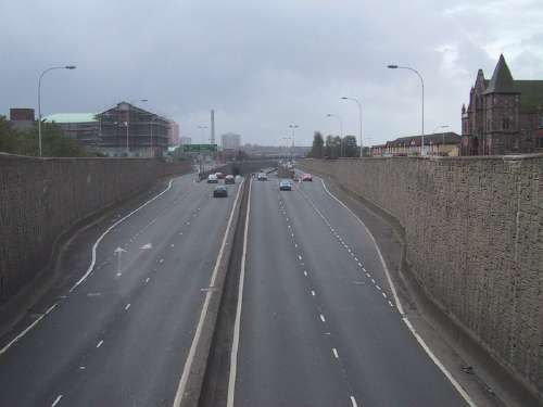
Looking back north from the Clifton Street bridge. The lorries on the left are about to join the Westlink northbound - imagine the forces acting on a vertical retaining wall this high with two lorries on top! This is the start of the "canyon" section of the Westlink. [Wesley Johnston]
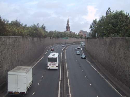
The view north from the next bridge, Peter's Hill, which does not have any access onto the A12. The spire is Carlisle Memorial Church at Carlisle Circus. [Wesley Johnston]
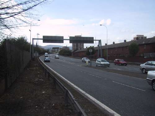
Looking south from the same bridge, Peter's Hill, towards the next junction at Divis Street. In the 1960s this area was all houses and shops. On the right is Townsend Street Presbyterian Church. [Wesley Johnston]
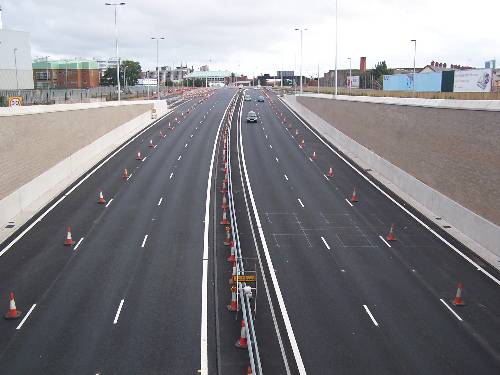
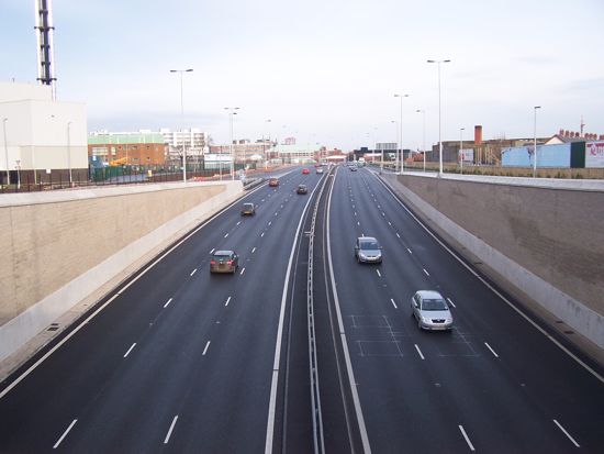
Looking south along the Westlink from Grosvenor Road flyover. This picture was taken in September 2008 before the third lane opened after the upgrade. The south facing sliproads are visible on the left and right - there are none facing north due to the proximity of Divis Street. [Wesley Johnston]
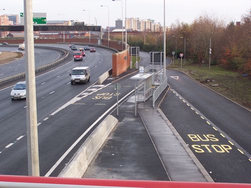
Coming round the corner from Grosvenor Road (to the top left in this image) the outbound bus lane from the Europa Bus Centre merges with the road. The fact that a bus stop has been placed at the this point, meaning that buses are expected to merge into dense traffic travelling at 50mph from a standing start is quite bizarre. The inbound bus lane runs adjacent to the Westlink from Broadway roundabout, visible on the right. Dec 2008. [Wesley Johnston]
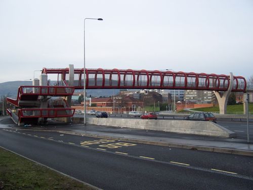
The previous picture was taken from the iconic tubular Roden Street footbridge. The bridge is designed to prevent vandals throwing objects onto the Westlink, yet still be attractive to look at. Dec 2008. [Wesley Johnston]
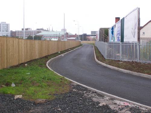
Access to the Royal Victoria Hospital site is provided at Mulhouse Road via a left-in/left-out junction, seen here from the Roden Street footbridge. There is no access southbound. Access to the site is also possible from Grosvenor Road and Broadway junctions, and indeed this entrance is closed by gates (just off frame to the right) during the night. Dec 2008. [Wesley Johnston]
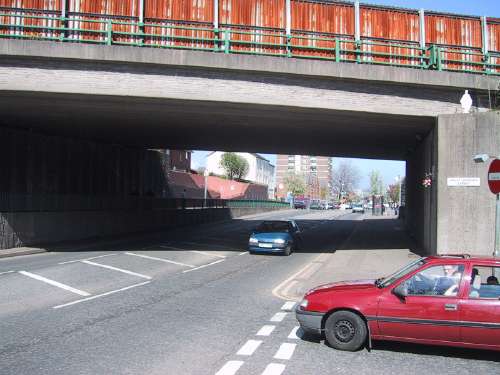
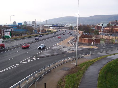
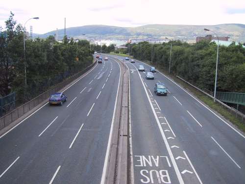
The Westlink terminates here, at Broadway roundabout. The road then seamlessly becomes the M1 motorway which descends down into the underpass below us. Dec 2008. [Wesley Johnston]
The inbound bus lane runs parallel to the east side of the Westlink from Broadway roundabout as far as Roden Street foorbridge where it turns away towards the Europa Bus Centre. July 2008. [Wesley Johnston] This section shows images of the Westlink as it looked at various points in the past.
The A12 Westlink shortly after opening in 1983 seen looking north from the Grosvenor Road roundabout (bottom). Today it would be difficult to imagine the road with such little traffic. [Photo from the UK Motorway Archive http://www .iht.org/motorway/wlink.htm]
The Grosvenor Road roundabout as it was from 1983 to 2006, here seen from the south side. The roundabout was large and flat, with trees growing in the centre and the south approach. [Wesley Johnston]
The Westlink looking south from the now-demolished original Roden Street footbridge around 2005. There was a traffic light controlled junction at Roden Street/Mulhouse Road at this time. [Wesley Johnston]
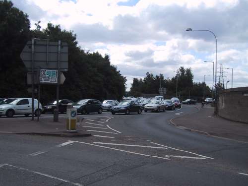
Broadway roundabout seen from Broadway on its western side around 2005 before it was grade separated. As you can see, the traffic was awful even at this point: mid morning on a Saturday. [Wesley Johnston]
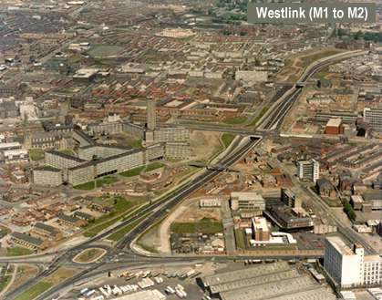
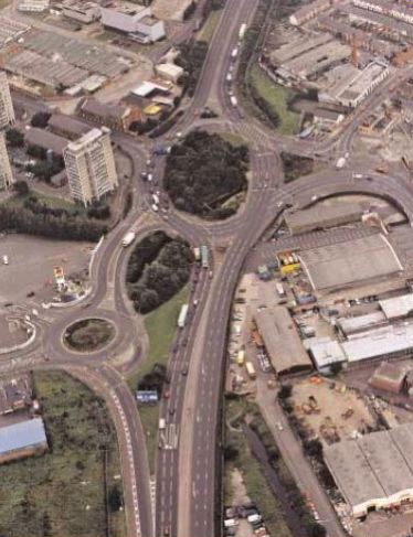
The Broadway roundabout from the air around 2004 with the Westlink to the top and M1 to the bottom, showing how it looked before the modern underpass was built. [Picture from issue 3, (2004), of the Northern Ireland Roads Service magazine "On the move"]
|
||||||||||||||||||||||||||||||||||||||||||||||||||||||||||||||||||||||||||||||||||||||||||||||||||||