|
|
Status
|
Construction scheme
(future) |
|
Where
|
To
construct direct free-flowing links
between the Westlink and the M2 and the
Westlink M3 at the York Street junction
in Belfast via a series of underpasses. |
|
Total
Length
|
n/a |
|
Dates
|
First proposed as part
of the Belfast Urban Motorway in 1967
This incarnation
first proposed - July 2006
Consultants appointed
- around Dec 2007
Plan given go-ahead -
Apr 2008
Public exhibition
held - 1 and 2 Jun 2011
Preferred option
announced - 6 Dec 2012
Ground investigations
contract began - 21 Jan 2013
Environmental
Statement and associated documents
published - 28 Jan 2015
Gateway 2 approval given - 14 May 2015
Public inquiry began
- 10 November 2015
Tender process
commenced - 22 November 2015
Tender process
revealed to be "on hold" - October 2016
Construction date unknown (as of Oct
2016) (changed from "late 2017" as of
Mar 2016; "early 2018" as of Oct 2014;
changed from "2014-18" as of Nov 2008)
Construction to last three years (as of
Jan 2015)
Appointment of contractor "set aside" by
courts following legal challenge - Aug
2018
DFI lose appeal to successful legal
challenge - Sep 2019
Review of scheme announced - 27 July
2020; this was completed by Dec 2020
Placemaking and Active Travel Review
published - 11 Oct 2022
Construction - scheme
paused as of Dec 2023.
Was to have begun Dec 2022, with
completion in Dec 2028 (as of Sep
2021)
No funds for
construction in the draft 2022-25
Executive budget
|
|
Cost
|
£130m as of Oct 2016
Theoretically
qualified for "up to 40%" EU funding
(ie, pre-Brexit)
(changed from £125m - £165m
as of Jan 2015; £100m - £135m as of
Dec 2012; £72m - £100m
depending on option chosen as of Jun
2011; "£50m" as of Nov 2007)
|
|
Photos
|
See below. |
|
See
Also
|
Official
web site on scheme - TransportNI
General
area map - Google Maps
M2
on this site
M3
on this site
Westlink on
this site
Westlink
upgrade on this site
Belfast
Urban Motorway history - on this
site
|
Click
here to jump straight down to updates
for this scheme.
Now that both the M1/Westlink and M2 upgrades
are completed, the last remaining at-grade
junction on the Belfast motorway network is the
York Street junction where the M2 meets the M3
and A12 Westlink. Freeflow links already exist
between the M2 and M3, but traffic wishing to go
between the M2 and A12 and the M3 and A12 must
use the traffic light junction at York Street.
The upgrades to these three roads have served to
highlight this as the final missing link in the
jigsaw with queues regularly stretching beyond
Fortwilliam and Grosvenor Road on a typical
working day.
These are the three busiest roads in Northern
Ireland (although, contrary to popular
impression, the Westlink is actually the least
busy of the three with the M2 being the
busiest). This junction is therefore the busiest
junction
in Northern Ireland, catering for
around 100,000 vehicles per day, yet it
currently relies on a series of traffic signals.
This is obviously not a good situation.
The current plan, as of December 2012, is to
completely grade separate all movements between
the Westlink and M2, and Westlink and M3 (M2 to M3
movements are already free flowing). This will be
achieved by constructing the four links mainly
below ground level. The graphic below shows the
proposed arrangement. This graphic is lifted from
a DRD leaflet which you can see in full resolution
here.
A more detailed plan of the proposed layout is
available at
this link.
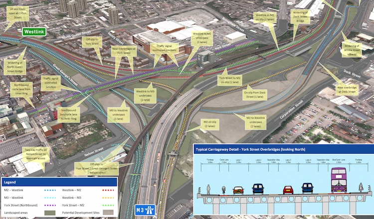 There are a few
less-obvious points worth highlighting to drivers
about this design: There are a few
less-obvious points worth highlighting to drivers
about this design:
- The short stretch between Clifton Street and
York Street will become a weaving section, ie
an onslip joins and shortly afterwards leaves
again as an offslip. This is similar to the M3
Lagan Bridge arrangement, except that the
sliproads will be just one lane each. It will
be interesting to see how well this performs.
- There will no longer be access to the local
road network at this junction when coming from
the M2. People wishing to drive into the city
centre from the M2 will have to leave at the
existing junction at Duncrue Street instead
and drive down Corporation Street.
- The link carrying traffic from the M3 to
Westlink will by only one lane wide, as
opposed to the current two-widening-to-three
arrangement. This has to be the case due to
the restrictions of the Westlink itself, but
will be interesting to see how this works in
practice.
- There will be a significant reduction of
traffic on the surface streets.
Historical Background
When the public inquiry that led
to the construction of the Westlink was
concluded in the late 1970s, it was decided to
construct the Westlink to York Street, and to
later build the M3 but that the junction between
the two would be at ground level with traffic
lights. The adjacent railway viaduct seemed to
rule out an easy grade separation, but Roads
Service have since changed their view and
decided to explore such a scheme. The scheme was
therefore officially proposed in the document "Expanding
the Strategic Road Improvement Programme"
released for consultation in July 2006. This
document envisaged an extra £400m for roads in
the period to 2015. The plans are very
reminiscent of the original 1960s plans for a
3-way motorway junction here (see below).
Between 2011 and 2012
Roads Service were considering four different
options to link the three roads together. Two of
these were fully freeflow, and two required
traffic lights on one of the links (see table
below). The various options each had different,
but equally important implications for the local
road network, especially access to and from the
city centre, to and from the Port of Belfast and
in some cases access to and from Clifton Street.
The plans and maps were outlined in a leaflet
published in June 2011, accessible
here. The table below outlines the key
points of the four options that were under
consideration. In December 2012, Option C was
selected.
| |
Option A |
Option B |
Option C |
Option D |
| Westlink to M2 |
Freeflow, underpass |
Freeflow, underpass |
Freeflow, underpass |
Freeflow, overbridge |
| M2 to Westlink |
Freeflow, underpass,
40mph limit likely |
Freeflow, overbridge,
50mph limit likely |
Freeflow, underpass,
40mph limit likely |
Freeflow, overbridge,
50mph limit likely |
| Westlink to M3 |
Freeflow, underpass |
Freeflow, underpass |
Freeflow, underpass |
Via street level traffic signals |
| M3 to Westlink |
Via street level traffic signals |
Freeflow, under York
Street |
Freeflow, under York
Street |
Freeflow, over York
Street |
| Effect on Clifton
Street junction |
As existing |
As existing |
As existing |
M2-bound onslip closed. Other three as
existing. |
| Access from Belfast
Port to Westlink |
Via Corporation Street |
Via Duncrue Street |
Via Corporation Street |
Via Duncrue Street |
| Other notes |
|
Overbridge ca. 18 metres above ground
level. |
|
Overbridge ca. 18 metres above ground
level. |
| Estimated cost |
£72m |
£100m |
£98m |
£95m |
Progress
10 Nov 2025: In a Question for Written
Answer in the Assembly in September 2025 (AQW
30340/22-27) the DFI Minister Liz McKimmins was
asked about this project. She said that the
"placemaking report" which Minister O'Dowd said
was being "reviewed" back in October 2024 "was
completed in May 2025, and a detailed report
has been presented to my office for
consideration" and "I have scheduled a
meeting with my officials to discuss the next
steps for the York Street Interchange project".
She also warns that the estimated cost of
£120-160m was given in 2015 prices and will
likely now be "significantly higher" – my
guess is over £200m. This is really the
important point because design work in and of
itself is all very well, but without a plan to
build it, it is all moot. She goes on to point
out what I said in the previous update, namely
that the scheme is not not an Executive flagship
project and does not currently have any funding
allocation, so there is currently no viable
pathway to construction. The only flicker of
hope is that the Minister did say "I have
asked my officials to review possible
alternative funding methods which could
facilitate scheme progression. This work is at
an early stage". To that I will just say,
good luck with that. The next news story about
this scheme will probably the publication of the
department's new transport strategy which should
come in the next few months and will tell us if
this scheme is still a runner.
22 Sep 2025: Unofficial word is that DFI
have moved towards a design for the road that is
more in line with what critics were proposing
ten years ago, namely to put most of the
junction below ground level and cover it over.
This will release surface land for various forms
of public realm development, and also including
some housing. The consultants working on the
scheme believe that the plans may go public
within the next year or so, though it's worth
noting again that it's not an Executive flagship
project and does not currently have any funding
allocation. The only way this might change would
be if the delays to the A5 project released some
cash – though of course there's no guarantee
that any cash released would go back to DFI as
it was allocated by the Executive. In any case,
it's an interesting development in the design
and it will be good to see how it is received.
13 Nov 2024: In the previous update DFI
Roads indicated that the work to analyse the
recommendations in the independent Placemaking
and Active Travel Review that was published in
October 2022 would be completed in "early 2024".
Since then we heard nothing, but Minister O'Dowd
was asked about it in the Assembly
in late October. He said "I met officials on
9 October 2024 to review the report, which
allows me to consider the way forward for the
scheme. Any subsequent decision to proceed
with the York Street interchange project can
only be made when I am confident that there is
budget certainty for the scheme and that its
delivery is in line with my Department's
emerging transport plans." It does feel
like work on the scheme is not considered a
priority by the Minister, but in fairness to him
the scheme has no funding, and has little
prospect of getting funding in the near future.
In addition, it is true that DFI is currently
working on a new transport strategy for the
Belfast area and the future of this scheme will
be decided by that report. So I don't expect to
see anything much happen on this scheme until at
least the publication of the Belfast area
transport plan, whose date we don't currently
know.
1 Dec 2023: In their latest
report to Belfast City Council, DFI Roads
have given an update on where we are with the
scheme, especially the consideration of the
recommendations in the independent Placemaking
and Active Travel Review that was published in
October 2022. DFI say that this work is ongoing,
and it appears to be considering how the
recommendations would impact the design and how
it could be built. This work is due to be
completed in "early 2024", ie quite soon. After
that work on the scheme will then be
paused, despite it not being formally paused in
DFI's August announcement
into scheme prioritisation since it has no
funding and is not an Executive "Flagship"
project. So, barring a reversal of this decision
by any future Executive, we can now consider
this scheme to be parked for the foreseeable
future. It will be interesting to see if, and in
what form, it appears in the forthcoming new
strategic transport plan (the RSTNTP) which is
due to be published in the next year or so.
1 Nov 2023: In August DFI Roads released
a document showing how the current roads
programme will be prioritised in the current
economic and legislative climate. This scheme
ended up not being formally "paused", despite
not being an Executive Flagship project, not
being funded through the New Deal agreement or
the Belfast City Deal, and having no other
source of funding. So essentially the project is
not going to happen any time soon and indeed may
not happen at all (its best opportunity was lost
in 2016-18 due to a botched procurement
process). While DFI are continuing to carry out
tweaks to the design of the scheme to take
account of the Placemaking and Active Travel
Review that was published this time last year,
the much more important question about the
future of the scheme is the strategic direction
of DFI. DFI are now working on a new strategic
transport plan (the RSTNTP) which will be
published in the next year or so. This plan will
itself be informed by the new 2022 legislation
that requires DFI to de-carbonise transport,
which presents a significant challenge to major
roadbuilding. So whether the scheme happens now
will hinge on whether it is compatible with the
emerging transport policies that come out of
this process. I am not going to speculate on
this – I think it could easily go either way for
this scheme. So not much more can be said about
this scheme until the RSTNTP is published.
14 Oct 2022: The DFI Minister has
finally released the Placemaking and Active
Travel Review alluded to in the last update in
August. Although the report is dated autumn
2022, the contents is clearly the three
"enhancement options" that were identified back
in 2021. You can download the report from here
- go down and look for "PAR" documents at the
bottom of the list on the right. Before
describing what is proposed, it is important to
clarify that this document is NOT a set of
proposals from DFI Roads, nor is it something
that DFI is proposing to build. Rather, it is a
report by independent consultants as to what
COULD be done to improve foot/cycle facilities
and the local streetscape in tandem with the
scheme. Whether any of these recommendations are
taken forward is ultimately up to the DFI
Minister.
The report notes that the current design (which
dates from 2015) is very poor in terms of local
streetscape, mainly because that was not in the
remit of the designers of the scheme. It also
notes that severance is severe and
pedestrian/cycle facilities are not good. It
recommends three options for improving this
problem while still broadly maintaining
the aims and the design of the scheme as
proposed. Each option is an enhancement of the
previous one. The names of the options were
derived from a much longer list, hence why they
are 3, 3A and 4. The costs are fairly vague in
the document, probably because they have not had
a detailed analysis, but from looking at them
the most ambitious option would certainly add at
least £10-20m to the bill.
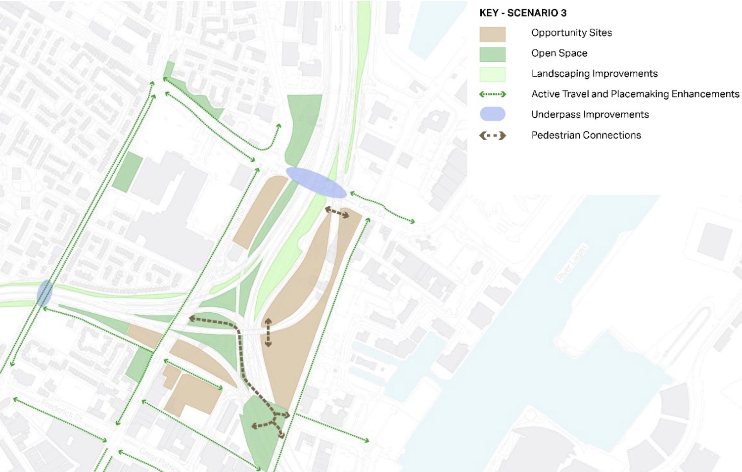
- Option 3 keeps the design as
proposed, but adds a new pedestrian/cycle way
through the centre of the junction, improved
environments under Dock Street and North Queen
Street bridges, and the addition of segregated
cycle lanes on various nearby streets such as
North Queen Street, Corporation Street and
York Street. The diagram below is from the
document and summaries option 3.
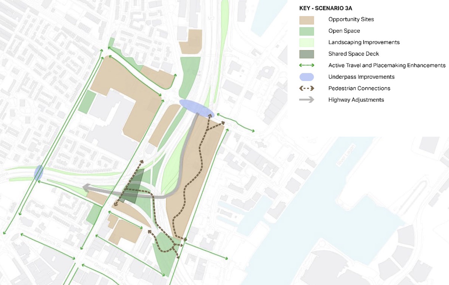
- Option 3A is as per option 3 but
modifies the design of the M2->Westlink
sliproad to make it tighter, and hence take up
less land adjacent to Corporation Street. The
appearance of the sliproad in the
visualisation below looks a little horrific
from a design point of view, but I suspect
it's meant to be indicative only. Such an
adjustment couid be done, but it would require
with a reduced speed limit due to the tighter
corner, which would then be of similar radius
to the Westlink->M3 movement. With this
alteration the land freed up would be returned
to community use. The design also features a
partial deck over part of the junction
adjacent to York Street which would be laid
out as a small park. The diagram below
summarises option 3A.
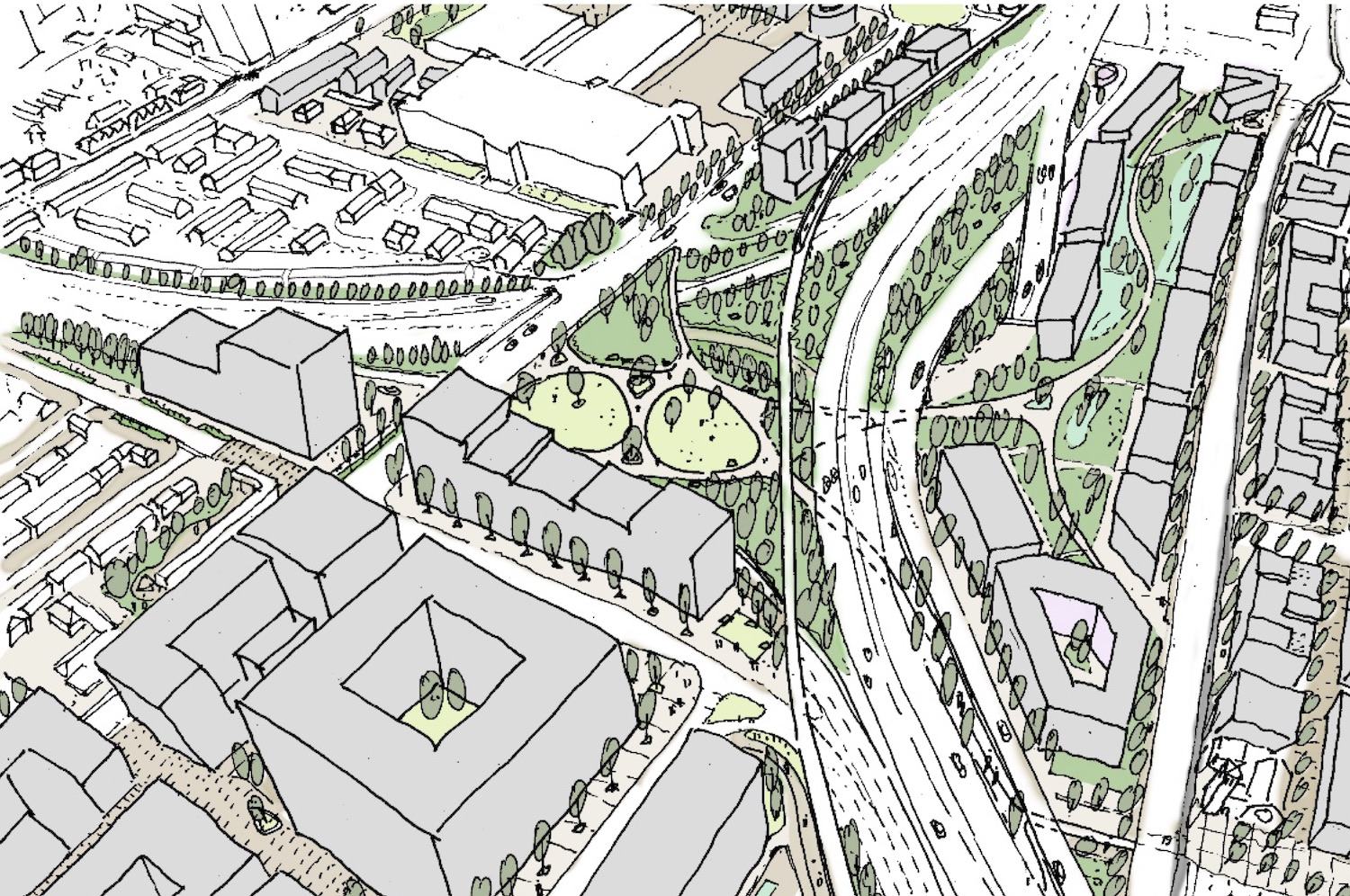
- Option 4 is as per option 3A
except that the deck is expanded to cover
a much larger part of the centre of the
junction, with a larger park on it. It
also features a similar deck over part of
Westlink at Clifton Street. This option is
much broader in its geographic scope,
taking in proposals on Dunbar Link and
including two new new footbridges over the
Lagan. This option is shown below, and
there is an artists' impression after
that.
Overall, all of these proposals sound very
good. However, they do go well beyond the
scope of the York Street Interchange
project so woudl certainly require
involvement of additional bodies such as
Belfast City Council. It's not clear how
the additional aspects would be funded
since some aspects, such as cycle
provision, is clearly within DFI's remit,
but elements like parks are not. What
happens next will really hinge on the
opinions of the DFI Minister as it would
need someone high up to drive the works.
24 Aug 2022: A brief addition to
the previous update to note this Written
Answer by the DFI Minister about six weeks
ago. In this he added that the work on
refinement of the shortlisted options as
recommended within the Placemaking and Active
Travel Review report will be completed "at
the end of the year" (we assume
calendar year, 2022). The previous Minister
never published the Review report that was
completed in 2021 - a document that is
definitely in the public interest - I sincerely
hope the new DFI minister publishes this latest
work once it is done. The Minister also took
time to note, in a recent
press release, that he remains "committed"
to the York Street Interchange.
10 Aug 2022: DFI recently published
the "first day briefing" that was given to the
DFI Minister John O'Dowd when he entered his
post in May 2022. It gives slightly more
information about the "options to enhance
place making and improve active travel
provision" which were recommended in the
as-yet unpublished report that was completed in
March 2021. It comments that the report "advises
that additional measures could be implemented
in tandem with it, to maximize the benefits
for communities. The report recommends that three
of the enhancement options are further
developed and refined to allow an informed
decision to be taken on the way forward."
This sounds as if the review is not a
fundamental revisiting of the scheme, but rather
focuses alternations to the design to better
accommodate active travel and perhaps also to
improve its appearance and how it ties into the
local area. The report also comments that the
current cost estimate (last given as £130m in
2016) is being revised to take account of the
changes to the design and also the significant
construction inflation that has been seen in the
past few years.
8 Jul 2022: The trail of inaction on
this scheme continues. The (new) DFI Minister
was asked about this scheme in a recent Written
Answer where he essentially reiterated the
position that his predecessor reported six
months ago. He again commented that "The
report [completed in Dec 2021] identified a
number of options to enhance place making and
improve active travel provision. Work is
ongoing to refine the shortlisted options and
consider factors relating to their potential
implementation." It does not sound to me
as if a lot of resources are being put into this
work at this time. This is perhaps
understandable since it currently has no funding
allocation for construction, at least until the
end of the draft budget in 2025, so there is
zero chance of it going back out to tender in
the near future. The Minister recently confirmed
that, to date, £22.3m has been spent on the
project.
16 Jan 2022: Last month the DFI Minister
was asked about the future of this scheme in an
oral
question time in the Assembly. Firstly,
she had previously said that further work was
being prepared by DFI in response to the "short,
sharp external review" that was completed in
March 2021. She said "work is ongoing to
maximise ambition on what can be delivered for
communities, connectivity and the wider Living
Places agenda. I expect to receive the report
this month. That will allow me to quickly
identify next steps". She should therefore
have received the report by now. It is now clear
what, if anything, will or can happen in the
next few months as Nichola Mallon is unlikely to
be the DFI Minister after the Assembly election
that is due in May. She did, however, make a
remarkable set of observations in the same
debate. She said "I recognise the strategic
importance of the scheme, but I want to make
sure that it is the right scheme, as I said,
for those who use it and for the communities
who live around it. They have been completely
separated. I would argue that the Westlink in
its current format has caused harm and
detriment to the communities who live around
it". The rationale for the scheme has
indeed been largely separated from the needs of
the community through the planning process to
date, by virtue of the fact that DFI's remit is
very narrow, limited to transport, so other
considerations are beyond what it has authority
over. This has indeed been a failing of the
demarcation of Stormont departments for some
years, but it is the first time I have ever
heard an infrastructure minister actually point
this out, and indeed speak in such negative
terms about one of the city's most vital road
links. With no significant funding allocated in
the most recent Stormont budget, I would not
expect to see much movement on this project in
the next year.
18 Oct 2021: Seven months ago the DFI
Minister announced the outcome of a "short,
sharp external review" into the scheme and
committed to further work on the matter. Nothing
has since been released, and this is getting
increasingly frustrating as it is clearly in the
public interest to know what is being
recommended and said behind the scenes. Two
weeks ago Belfast City Council passed
a motion calling on the Minister to let
them have immediate sight of the outcome of the
Independent Assurance Review of the York Street
Interchange. The rationale for this move,
according to the motion, is as follows: "This
Council notes that it is currently corporately
committed to supporting the York Street
Interchange project. This decision was made
before this Council declared a climate
emergency; before the NI Assembly declared a
climate emergency and before the most recent
Intergovernmental Panel on Climate Change’s
Report published in August 2021, which was a
‘Code Red’ warning for humanity. Belfast City
Council is a key stakeholder in the York
Street Interchange Project and sits on the
Strategic Advisory Group for the York Street
Interchange. [Releasing the information] will
allow us to make an informed decision on
whether we as a Council continue with our
corporate support for this project." The
official position remains that Belfast City
Council is supportive of the scheme. If the
council were to withdraw its support it would be
reminiscent of the decision by the same council
to withdraw its support for the Belfast Urban
Motorway in 1973, being one of the reasons
the scheme was eventually scrapped.
25 Jul 2021: DFI's most
recent report to Belfast City Council
provides an update on this scheme. It doesn't
really say much more, but does elaborate on what
the consultants are currently doing. It is worth
quoting at length: "further work is being
carried out, particularly around place making
and to maximise ambition in terms of what can
be delivered for communities, connectivity and
the wider living places agenda. It is proposed
that this work will also take into account the
further development of Bolder Belfast .The
Strategic Advisory Group for the scheme will
also be reconvened and the communications
strategy updated to ensure local communities
and other stakeholders are kept informed of
future developments." "Bolder Belfast"
refers to a document published in 2020 by
Belfast City Council which envisions a city
centre more focused around pedestrians, cycling
public transport and a focus on removing
barriers. The group is due to report back to the
DFI Minister in the autumn of 2021. For what it
is worth, my gut feeling is that the legal
challenge that DFI lost in 2018 has killed York
Street Interchange in the form envisaged, but
that a new design will be developed that softens
the severance effect of the scheme while still
providing the key benefits of removing through
traffic from surface streets.
4 Apr 2021: On 26 March the DFI Minister
announced the outcome
of her "short, sharp external review" of
the project, which she initiated in July 2020.
The "independent panel" made six recommendations
as follows. My comments are in italics.
- The YSI project brief should be reviewed and
revised to ensure it aligns with the concept
of “place making” and new best practice in
terms of urban transport design, and with the
Minister’s agenda. [This I interpret to
mean that the scheme should be seen as more
than just a transport scheme, and so also
take into account the scheme's sensitive
location and other needs people have.]
- The wider area impact and benefits of the
Project should be evaluated using appropriate
quantitative and qualitative assessment
mechanisms. [This I think means that more
work should be done to assess both the
benefits and the problems that the scheme
would bring to allow a fuller understanding
of the winners and losers. This is similar
to recommendations made recently by the
Inquiry Inspector on the A5 scheme and does
reflect current thinking.]
- The current Project costs should be updated
to act as a benchmark to inform any decision
on future alternative development. [Scheme
costs were last published five years ago, so
it makes sense to update them.]
- There needs to be a system of ongoing
communications with all interested parties.
This should include updating the 2017
Communications Strategy and employing a robust
Communications Structure now as well as during
any construction phase. Communications
should be ongoing and not just point in time.
[Talk more to the public!]
- There needs be much closer co-ordination
both within the DfI and between DfI and other
relevant departments and interested parties at
both policy and delivery levels with regard to
YSI development and delivery. [The Northern
Ireland government suffers from different
departments having very specific briefs and
their Ministers often coming from different
political parties. DFI's role is
specifically transport, so other areas such
as "place making" are often outside their
remit. This recommendation is to try to do
better in this regard. This will be
difficult in practice for the reasons stated
as it needs agreement at Executive level.]
- There needs to be a co-ordinated decision
made in the context of emerging policies,
which then needs to be applied to ensure that
the YSI project aligns to this context. [It
is not clear what this means - perhaps that
York Street Interchange needs to be
compatible with the new transport plans
being developed, or with new policies
towards sustainable transport].
The Minister has accepted all six
recommendations, and has instructed the scheme's
consultants to "carry out further work
particularly around place making and to
maximise ambition in terms of what can be
delivered for communities, connectivity and
the wider living places agenda". She has
asked for this work to be completed by autumn
2021. She did not take the opportunity to
re-state her support for the scheme (though she
did do so not long ago, in July 2020) and is
still talking in terms of all this work taking
place "before I make a decision on the next
steps for the scheme". My feeling is that
the process is likely to result in relatively
minor tweaks to the design to make the road
links less intrusive, to plan for a better
resultant screetscape that is less of a barrier
to pedestrians and cyclists, but still
maintaining the underlying principle of taking
strategic through-traffic off the surface
streets and onto dedicated links. It could well
result in a win-win situation if done well.
However the whole process, which has been
underway now for 15 years, will drag out for
several more years.
22 Jan 2021: The new DFI Minister
announced a "short, sharp external review"
of the project in July 2020. According to a
briefing given to the Infrastructure Committee
in Stormont on 9 December 2020, "this
[review] has been completed and the
Minister is considering its findings before
deciding on next steps". Budget-wise the
scheme is officially listed as a "pre-committed"
scheme and is included with the qualifier "New
Decade New Approach". NDNA did not specify
particular schemes for money to go towards, but
this shows that DFI clearly regard this as one
of the candidates of the additional investment
envisaged by NDNA. The scheme had been due to go
back out to tender in June 2020, but that did
not happen due to the Minister's intervention.
On the Investment
Strategy for NI web site the scheme is
currently listed as going out to tender in "June
2021" and has construction due to begin by
December 2023 and to last four years. These
timescales are surely indicative, anyway, as the
Minister has not yet made clear her intentions
for the scheme.
The Department of Finance issued its draft
annual budget on 18 January which includes
£693.2m of capital funding. The budget does not
set out any more detail but, to put this in
perspective, over the next year DFI needs £72.7m
in order to progress the projects already under
construction and an additional £441.3m to cover
"inescapable" costs such as NI Water and
Translink. This would still leave £179.2m of
additional funding for other
pre-committed/desirable schemes. DFI wanted a
relatively modest £4.6m this year in order to
continue work on York Street Interchange, and
the draft budget suggests this will be possible.
So really now we are just awaiting the
Minister's decision on whether she is content
for the scheme to progress, or whether she wants
to re-visit the objectives and/or design. It is
again worth noting that York Street Interchange
is not a "flagship" scheme, and
therefore does not have a ring-fenced budget.
Draft Budget 2021-
27 July 2020: In my update below on 25
May 2020 I expressed the view that this scheme
was at risk due to shifts in public opinion,
lack of money, changing travel patterns and
recent court judgements. This was borne out
today when the DFI Minister announced
what she calls a "short, sharp external
review" of the project. The terms of
reference for the review are to "focus on the
scheme’s ability to deliver the following and
consider any other issues highlighted":
- The Minister’s priorities around focus on
well-being, sustainable travel, creating
thriving liveable places and communities,
responding to the climate emergency and
connecting people and opportunities;
- The Executive’s priorities set out in New
Decade: New Approach and the Outcomes Delivery
Plan, and ;
- The scheme’s strategic fit alongside the
emerging policy context, for example, the
Belfast Agenda, the Belfast City Council
Development Plan Strategy and the emerging
Transport Plans.
Although not explicitly mentioned, I think DFI
must be aware that the scheme is at great risk
from a legal challenge on sustainability grounds
following the successful legal challenge to the
Heathrow third runway, where judges ruled that
schemes must take into account the government's
stated aim of reducing carbon emissions. So they
may have concluded that some kind of review is
preferable to a time-consuming legal challenge.
In addition, time is passing (even the public
inquiry was almost 5 years ago) and the more
time goes on the more out of date the planning
risks being. Thirdly, there has been a lot of
opposition to the current design (and it is
organised opposition) in the north Belfast area
and a feeling that the scheme could give greater
weight to the need to reduce the severance
effect on north Belfast and to free up more
opportunities around the junction for
development than the current design permits. In
my view, these are all good reasons to have a
review and I think there is potential here to
bring about a better outcome. The Minister's
used of the phrase "short sharp review" is
clearly intended to counter fears that this is
another delay - but clearly if the design
changes in a significant way then it would
likely require a new public inquiry and a new
procurement process, all of which could add a
couple of years to the project timescale.
It is worth noting that the Minister has also
stressed her commitment to proceeding with the
scheme. She said "I recognise the strategic
importance of the York Street
Interchange. Its inclusion in the New
Decade New Approach Agreement is a further
indication of the significance of the project
to our economic and societal wellbeing and I
am determined to see it delivered". At the
same time, the Executive has not given it any
funding for construction so at this stage it
remains an aspiration.
12 Jun 2020: The DFI Minister announced
her budget
for the next year, which allocated money to the
Executive's flagship projects (A5, A6 and
Belfast Transport Hub) but did not give any
funding for any other capital road schemes,
including this one. She followed this up today
with a press
release clarifying that she had approved
funding for the continuation of planning of
several planned road schemes, and went on to
give seven examples ("such as") of schemes, four
of which were bypasses. The glaring omission
from the list was York Street Interchange. I
would read this press release as an indication
of what the new Minister's priorities are, and
they seem to be regional schemes across the
province. It appears that she does not regard
York Street Interchange as a priority. So, on
this basis, I would not expect to see work
commencing on this scheme in the near future.
25 May 2020: In the last update six
months ago (see below) I said that the tender
process would begin again in June 2020. This
timeline appears to be correct, as at least one
of the bidding contractors was told last month
to prepare for re-pricing their bid. However
nothing whatsoever has appeared on the DFI's own
procurement
web page. It could be that DFI are not going
back to square one, but rather going back only
to the shortlisted tenderers from last time,
which could be regarded as a continuation of the
previous tender process. If that's the case then
a contractor could be appointed either towards
the end of 2020, or early 2021. Flaws in the
evaluation process were what triggered the
successful legal challenge to the previous
tender process in 2018. The ISNI
web site (that tracks large NI government
contracts) still suggests construction could
begin in September 2022 and end in 2026.
Nevertheless, I am coming round to the view
that this project may not happen at all. There
are a number of reasons for saying this. (1) In
the light of the Heathrow Airport court ruling,
York Street Interchange is highly susceptible to
a legal challenge along similar lines which
could, at the very least, delay the project. (2)
It is not clear whether the money for the
project still exists (it had been funded as part
of the now-defunct DUP-Tory pact) and, even if
it does, the deep recession that will follow
after COVID-19 will throw all major
infrastructure spending under the spotlight. (3)
Travel patterns are likely to be disrupted by
the global pandemic and associated lockdown,
meaning that past traffic modelling may prove
redundant going forward. This is not to say that
the scheme would suddenly become unjustified -
merely that, as stewards of public money, it
would make sense to look seriously at the
question before committing this level of cash.
(4) Public opinion, at least in the North
Belfast area, seems to be increasingly vocal in
their opposition to the project in the form
proposed. This is also influenced by the Greta
Thunberg phenomenon and recent attention given
to the "climate emergency". See this
news story, for example. To be clear, I am
NOT saying that I am opposed to the project,
merely that in my judgement it is looking
questionable whether it will happen. It is very
reminiscent of the way the Urban
Motorway in the early 1970s was killed off
by lack of cash and the Oil Crisis. It could be,
looking back from the future, that 2018 was York
Street Interchange's last chance to be built,
one that was lost by DFI's own tender evaluation
process. I recently took part in a
video chat with Mark Hackett, who has
proposed a scaled-back project which would bring
some, albeit reduced, benefits for vehicles in
order to reduce the scheme's impact.
20 Nov 2019: After last year's
successful legal challenge to the tender process
for this scheme, we had been wondering whether
the tender process would have to be re-run. DFI
have now revealed that the answer is "yes". The
ISNI
web site (that tracks large NI government
contracts) has been updated to indicate that the
tender process will begin again in June 2020
(seven years after the first time it went out to
tender!), with a contractor to be appointed by
June 2021. Interestingly, it then gives an
estimated construction start date of September
2022, with completion in March 2026. This, of
course, assumes there is funding. There are some
knowns and some important unknowns in this
regard. Here is what we know: (1) The scheme was
NOT included in the Executive's Programme for
Government. Therefore, it had not been allocated
any funding at the point that the Executive
collapsed. The Civil Service has, to date,
continued to follow the PfG and seems
reluctant to stray from it. (2) Although the
scheme qualified in theory for some EU money,
the outgoing DFI Minister did not apply for this
because (he said) the next EU funding round
would take it beyond the date of Brexit. (3) As
part of the DUP-Tory pact of June 2017, the DUP
negotiated funding for the scheme. (4) The
scheme has not gone ahead during the lifetime of
the pact due to the successful legal challenge.
This suggests that, if the pact is not renewed
after the election, the funding may well be lost
and without an Executive there may be nobody
prepared to bring it forward and give it funding
from another source. (5) However an unknown
is where the money that was to have been spent
on YSI is now. Has it already been passed over,
and is sitting somewhere, still accessible? Is
it still in London, and potentially lost? The
answer to that question is very relevant and
unknown. (6) Finally, it's worth noting that the
date of 2022 is beyond the completion of two of
the main projects in the Programme for
Government, namely both A6 dualling schemes, and
part way through the first two phases of the A5
dualling scheme. The former Executive has left
no guidelines as to what could come next at that
point. It could be that DFI believe that the
scheme should come next in the queue. Whether
this happens will depend on who is making the
decisions in 2022. With thanks to Jonathan Craig
for alerting me to the tender notice on the ISNI
web site.
11 Sep 2019: As a reminder, DFI
appointed a contractor for this scheme early in
2017, which was immediately challenged in court
by one of the losing contractors (BAM/McCann).
That legal challenge was successful, and the
court "set aside" the contractor appointment in
August 2018. DFI appealed this decision, and the
court last week finally gave their judgement to
the appeal - and it was a loss for DFI.
The Lord Justice said "It may well seem
regrettable that a much needed and very
important piece of road improvement has been
delayed because the panel evaluating the two
tenders made two quite narrow errors in their
assessment. However, those two narrow
errors, it is agreed, were enough to alter the
award of the contract between the plaintiffs
and the previously successful tenderer."
So the conclusion is that the procurement
process was not carried out correctly by DFI
with the result that, had it been carried out
without the two errors mentioned, BAM/McCann
would have won the cotnract, and were therefore
justified in launching legal action. It means
DFI will either have to re-run the tendering
process, or else enter into some kind of
compensation arrangement, both which will be
costly. However, the delay caused by the
legal challenge does, in my view, seriously
jeopardise the viability of this scheme. The
scheme did NOT receive any funding from the
outgoing Northern Ireland Executive, was not a
flasgship project and was therefore not to have
gone ahead in the near future. That changed with
the 2017 DUP-Tory pact promised funding for the
scheme, but with the future of the UK government
and that pact looking very shakey indeed, it
seems very likely that this funding will be gone
by the time procurement is completed. With no
Executive to allocate funding to the scheme,
little can be done about this. As a result, this
scheme may now not happen at all, or if it does,
it may not be for many years. It is not DFI's
finest hour.
23 Jul 2019: It has been a year, now,
since the appointment of the contractor was "set
aside" by the court following a successful legal
challenge by BAM/McCann. In December (see
previous update) it emerged that DFI had decided
to launch an appeal to the ruling, but we have
not heard anything since then. However, the recently-published
report to Lisburn & Castlereagh Council
confirms that "an appeal has now been heard
and the judgement is awaited". No time
table is given for when the ruling might be
expected. The funding for this project is from
the DUP-Tory pact which does, perhaps against
the odds, continue to persist and so the funding
is still there should there be a favourable
ruling, though it could disappear at any moment.
If DFI lose the appeal then it seems likely that
the procurement process would have to be re-run,
which would add many months to the project. The
Report also says "Following a Ministerial
direction, the process of consulting local
residents and key stakeholders on issues
identified in the Inspector’s Report has now
commenced". As there isn't currently a
Minister, this is presumably a ministerial
direction from over two years ago - the
Inspector's Report referred to was published in
November 2016.
3 Dec 2018: A court ruling in August
found that the DFI had made mistakes during the
procurement process and set aside the award of
the contract. We had expected the next step to
be some kind of remedial work, which would
involve either paying compensation to one of the
involved parties or re-running the procurement
process. However, it emerged last week that DFI
have instead opted to launch an appeal to the
ruling itself, ie they are challenging the
ruling that they made mistakes. This surprises
me in that it will add several months to the
timescale of the project at a time when the
funding for the project is hanging by a thread.
However, it is true that re-running the
procurement process would also add several
months to the timescale. They would not be
appealing if they had not been given advice that
they had a reasonable chance of success, so this
will be an interesting one to watch in the
coming months. Whatever happens, I would not
expect to see any work happening on the scheme
in the short term.
15 Nov 2018: This scheme is hanging by a
thread. As we know, the scheme has funding via
the DUP-Tory pact in Westminster. The events in
London today have seen the DUP say that they
will vote against the government's Brexit deal
with the EU. Since supporting this legislation
is part of the DUP-Tory pact, were they to do so
it would mean the end of the pact. Some funding
for York Street Interchange was included in the
most recent budget, but I suspect it may not be
enough to complete the priject. If the pact does
collapse, then the remainding (future) funding
for York Street Interchange disappears too. So
that means that this scheme might well be about
to die for the foreseeable future. This could
render the recent legal challenge, and concerns
about having to re-run some or all of the
tendering process, irrelevant.
11 Nov 2018: In August the DFI lost a
court case brought by BAM/McCann, who did not
win the tender, and alleged that the procurement
process was flawed. The scheme did have funding
(via the DUP-Tory pact) and was shovel-ready, so
this court case meant that the road could not
progress during 2018 as had been planned. A further
legal hearing was held in October to
determine what should happen by way of remedy.
In this hearing, BAM/McCann argued that the
court should declare that it would be "lawful"
to award the contract to them instead, but the
judge declined to do this, stating that it was
sufficient that the court had "set aside" the
award to the winning contractor. This does open
up the real possibility that the tender process
may have to be re-run, which could potentially
add 6-9 months on to the project timescale. That
is a big risk, because the DUP-Tory pact - upon
which this scheme is entirely relient for its
funding - runs out in June 2019 (and may
collapse before then). If that happens, the
scheme may eventually return to a shovel-ready
state, but no longer have any funding. New
funding is unlikely to appear without a return
to Stormont power sharing. The upshot of all
this is that in a worst-case scenario the
mistakes that were made in the tender process,
and the consequent legal challenge, may have
killed this scheme entirely.
12 Aug 2018: The ruling in the
long-running (16 month) legal challenge to the
contract award for this project finally
came last week. The case was brought by
BAM/McCann who did not win the tender. The judge
ruled that mistakes had been made by DFI during
the procurement process and in particular that
it was a mistake for the DFI tender evaluation
panel to conclude that BAM/McCann had not
properly understood the project. The DFI panel
also said that BAM/McCann had not provided
enough detail about phasing of work but the
judge said that the DFI panel had not been
transparent enough about the amount of detail it
was expecting. What happens next will be decided
at a hearing in September. However, it is likely
to result in either (a) the tender process being
re-run, with compensation due to the current
winning contractor or (b) the tender award
remaining as it is, with compensation due to
BAM/McCann. The first option could add a further
6 to 9 months to the timescale of the project,
while the second would be quicker. Either way,
the public purse is going to lose out with
compensation seemingly due to somebody no matter
what the outcome.
The big risk for the project is that the
scheme had no funding allocation until the
DUP-Tory confidence-and-supply pact of June 2017
which promised £2bn funding for Northern Ireland
over two years, including funding for this
project. The two years runs out in June 2019 -
indeed, the pact could end at any moment. Once
the pact ends it is likely that any unspent
funding from the £2bn will disappear too.
Therefore, if work on York Street Interchange
has not commenced by June 2019, or before the
pact ends, the project may not happen at all.
The hearing in September should help to answer
this question of timescales. Finally, I don’t
think that the lack of a Minister is likely to
be an issue - the project has ministerial
approval and has not changed since then.
Awarding a tender for a project that already has
ministerial approval does not require further
ministerial approval.
21 Jul 2018: A statement
by the UK government on 28 June contained a
reference to this scheme, which was to be funded
by cash from the DUP-Tory pact of June 2017. The
money has yet to appear a year on, but this
statement said "We will ensure that our
commitments on major infrastructure spending,
including the York Street Interchange road
project and the broadband investment
programme, agreed alongside of the Confidence
and Supply Agreement with the Democratic
Unionist Party, are able to be taken forward
so that the people of Northern Ireland benefit
from the increased investment agreed in June
2017". This means that really the only
obstacle to the scheme is now the ongoing court
challenge brought by one of the bidding
contractors. The court has STILL not given its
ruling on the case even though it's now been
four months since the hearing. As the funding
would be likely to disappear if the DUP-Tory
pact were to collapse, the clock is really
ticking on this. There is a real possibility
that the scheme could be scuppered entirely as a
result of the delay caused by the legal
challenge. Let us hope that the outcome is known
soon and that the scheme can progress to
construction. Even if the outcome was known
tomorrow, there are still several months of
detailed design and planning to be done, so
commencement is now going to be no earlier than
2019, the tenth anniversary of the completion of
the M1/Westlink upgrade.
22 Mar 2018: The scheme has sat in limbo
since a legal challenge to the award of the
construction tender was made by BAM and FP
McCann over a year ago. There was, at last, a
court hearing in Belfast High Court
beginning on 5 March but as yet I have not heard
any outcome. In any case, it's largely a moot
point since the scheme still has no funding
allocation, though there is still the possiblity
that some of the funding made available via the
Tory-DUP pact - and which seems to have been
included in the recent Westminster-passed
Northern Ireland budget - could be used to fund
this scheme. DFI have continued to talk to local
residents and stakeholders about the plans.
7 Jan 2018: A legal challenge to the
appointment of the contractor was made almost a
year ago, and the status of the scheme has sat
in limbo ever since. According to this report
given to Belfast City Council the legal hearing
has been scheduled for Febraury 2018. Meanwhile,
"the process of consulting local residents
and key stakeholders on issues identified in
the Inspector’s Report had since commenced".
This refers to the report of the public inquiry
which was published in December 2016 and made
some recommended tweaks to the design. Finally,
the Tory-DUP deal last June which included
funding for this scheme is still in place, but
as yet none of the funding has actually
appeared, so even if the legal challenge is
decided there is still no money to build it.
10 Jul 2017: Despite the lack of
optimism in my previous update below, a deal
between the DUP and Conservative Party resulted
in funding
actually appearing out of the ether (or
more accurately, British taxpayers) in late June
to construct York Street Interchange. A
tremendous amount of ink has been spilled
elsewhere talking about the merits or otherwise
of the DUP/Tory pact or the fact that this
scheme and no others were explicitly funded, so
I am not going to discuss that here. Instead I
will proceed forwards from the factual point
that the money has now been made available. The
scheme has been very close to being shovel-ready
now for some time. The process to appoint a
contractor is on hold due to a legal challenge
which is likely to take until early 2018 to
resolve. Nevertheless DFI Roads (the new name
for TransportNI) have said since the funding was
announced that the earliest start date would be
2019. I have not had the reason for this
confirmed, but I would speculate that it is
because the final detailed design has not yet
been completed. In recent DFI Roads contracts,
such the dualling of the A6, the appointed
contractor assists with completing the design
prior to beginning work, which can take a number
of months. In addition, the contractor will need
some time to ramp up for a project of this
nature in a uniquely confined site that will
likely require large cranes and a traffic
management plan worthy of a small army. The
Tory/DUP money must be spent within two years,
which is cutting it fine, but it's likely that
financiers at Stormont will be able to do some
financial jiggery-pokery that will make it work.
Of course, it is also possible that the DUP/Tory
deal might fall apart long before 2019 in which
case this money might return to the ether from
whence it came. As I often say, nothing is
certain until the bulldozers are on the site.
13 Apr 2017: In my previous update I
said that a contractor had been appointed but
not publicly announced. No announcement ever
came. It has since emerged that the reason for
this is that one of the unsuccessful contractors
has launched a legal challenge to the
appointment. Nothing more has been said
publicly, but it seems that it comes down to the
way the tenders were assessed, in particular the
relative weight given to cost versus prior
experience of similar schemes. The legal
challenge looks likely to delay this scheme by
about nine months, which sounds bad, but in
practice is likely to be a moot point since the
scheme has no funding allocation (for
construction) anyway, nor do we have a
functioning Executive that could allocate such
funding. So at this point the earliest possible
start date for the scheme – assuming that
funding miraculously appears out of the ether –
would be early 2018. But my pragmatic side is
saying that even this is optimistic, with
funding likely to remain focused on the A5 and
A6 for the foreseeable future.
26 Feb 2017: The legal order required to
give DFI permission to build this scheme was
published on 24 January, to come into operation
on 7 March. You can read
it here (it may help if you're having
difficulty sleeping!). Building a new trunk road
involves a number of legal orders, so this is
just one of the legal steps required to make it
happen. But it does suggest active work. The
scheme has been out to tender since November
2015, but the grapevine is suggesting that a
contractor has recently been appointed for
design and construction. Nothing has been said
publicly, however, so we'll have to await the
public announcement before we can say any more.
What this does, at least, suggest is that the
tendering process is no longer "on hold" as was
the case last autumn. The big unknown is still
money - there is currently a need, a design, a
strong will and perhaps a contractor... but
insufficient money. The outcome of the Assembly
election this week will help determine the
future direction of Northern Ireland's
government, so for now we can only wait.
28 Jan 2017: With an Assembly election
looming, the outgoing DFI Minister released a
press release on 24 January about this scheme,
(though oddly it doesn't currently appear on the
DFI web site). In it he said "funding of up
to £4million will be made available to develop
the York Street Interchange Scheme to a
construction ready state and has confirmed
that contract award for the scheme development
will be progressed". He went on to say
that the funding would "allow the scheme to
be developed to a point where construction
could begin. The identification of funding for
the construction phase will be dependent on
future budgets and is unclear at this time".
This is absolutely full of caveats. All it is
really saying is that development work will
continue but that there is no money to build it
and no timescale for doing so. The note that "contract
award for the scheme development will be
progressed" is interestingly worded. The
contract for schemes like this is usually
divided into a design phase and a build phase,
with the contractor involved in both but a
"break" clause between them so that the scheme
could conceivably not be built even with a
contractor appointed. The wording of the press
release seems to be saying that a contractor
will be appointed (but doesn't say when) and
that this would be for scheme "development", ie
the design phase. In summary, I would read this
press release as an attempt to show that the
Minister supports the scheme and wants to
progress it, but as a press release it also
succeeds at not committing to actually doing so
or to any particular timescale. So I think it's
a case of "as you were".
26 Dec 2016: As predicted in the
previous update, the Minister announced
his intention to proceed with the York
Street Interchange scheme on 15 November, though
I have not had a chance to update the site until
now. Four things were published on this date.
Firstly, there is Inspector's report of
the public inquiry which was held in November
2015. The inspector has basically recommended
that the scheme proceed in its current form,
with only minor tweaks, ie as a series of
underpasses creating freeflow links on all four
movements between Westlink and the M2 and
Westlink and the M3. You can download the
Inspector's report from this
page. Secondly, the Departmental
Statement was also published. This is the
DFI's official response to the Inspector's
report, and sets out their reaction to each of
the inspectors' recommendations. The
Departmental Statement can also be downloaded
from this
page. Thirdly, the Notice to Proceed
basically sets out formally that they intend to
move towards construction. And finally, the Designation
Order is a legal document needed to give
TransportNI permission to build new sections of
trunk road. This is all well and good, but the
one thing missing from the equation is the money
needed to build it, and therefore also any
timetable for construction. The procurement
process is technically underway, but currently
on hold. The decision to put the tender award on
hold resulted in a lot of debate in October,
most notably in the Assembly in late 2016 where
you can see a range of written
questions on the subject.
The Minister clarified his position on 20
October 2016 in a press
release and it worth quoting him at
length: "while [York Street Interchange] is a
project that could have attracted up to 40% EU
funding, there would still be a 60% gap to
make up. My Department has of course been
pursuing European funding for York Street
Interchange through the Connecting Europe
Facility. Unlike structural funds, this is a
highly competitive funding programme with
member states required to submit applications
as part of a formal bidding process. This is
implemented by a series of calls for funding.
The next call for major projects is
anticipated for early 2018. As a result, the
funding stream for this project goes beyond
the timeframe set by the chancellor [who
guaranteed to cover EU funding up to the date
of the UK's departure from the EU]. To clarify
the position on procurement of the York Street
project specifically, the bidding exercise has
now been extended so procurement decisions can
be made in line with future funding
allocations.” Note that in the same press
release he gave the cost of the scheme as £130m,
which is more specific and surprisingly better
than the £125m-165m being quoted two years ago,
so we will run with that.
So the position of the Minister is that the
scheme will go ahead, but that the earliest
possible date to apply or EU funding is early
2018. That may well be true, and I have no
reason to doubt the Minister, but something
doesn't quite add up in my head here. On 15
March 2016 the then-DRD Minister Michelle
McIlveen released a press release announcing the
start of the procurement process and stating
that "Construction is programmed to commence
late in 2017 and be completed by the end of
2020". This press release has mysteriously
vanished from the Executive press release archive
but it was reported by the BBC the next
day. The press release explicitly
states that justification for going out to
procurement at that stage was in order to
qualify for EU funding, and at this stage it was
obvious from all conversations that the
intention was to proceed with part EU funding
(up to 40%). Both the above press release and
folks I spoke to in TransportNI in this period
seemed to be working on the assumption that it
would begin in late 2017 and that there would be
EU funding. However, the new DFI Minister is now
quite clear that the earliest possible date to
even apply for EU funding is early 2018.
If that is true, then commencement in late 2017
was surely never on the cards? And that means
that either someone senior in the DRD was wrong
in March 2016 or someone senior in the DFI is
wrong now. So I continue to hold the view that
there is something more going on here than the
mere availability of funding. Time will surely
tell.
19 Oct 2016: Yesterday TransportNI
issued their updated "procurement
plan" for the current financial year. This
document is mainly for the benefit of
contractors and allows us to see what contracts
have been awarded, are to be awarded and which
are yet to go to tender. The tender process for
this scheme is currently underway (and has been
since March when the proper tender process
began) but tellingly, York Street Interchange is
listed in the procurement plan "on hold", the
only scheme in the list to say this. This is yet
another indication that the timescale of this
scheme is now much less certain. This evening
InfrastructureNI tweeted
the clarification: "Progress on the York
Street Interchange scheme to be determined by
the forthcoming Budget process. Until then,
procurement on hold". As I have said
before (see update below on 17 Aug for example)
since May the scheme has had the double hit of
(a) Brexit potentially torbedoeing its EU
funding (up to 40%) plus (b) a Minister who is
very keen to invest in roads in the North West
and clearly views the A5 and A6 as higher
priorities. The former, likely influenced by the
latter to some extent, is the likely reason for
the tender process now being put "on hold".
TransportNI had previously said they wanted the
scheme to go to ground in Autumn 2017, and this
seems unlikely now. That said, the scheme has
not been cancelled, merely delayed. The tweet by
InfrastructureNI is correct that there is to be
a budget announcement sometime later in the
autumn which could (potentially) release
additional funds for York Street Interchange.
There is also the UK Chancellor's guarantee to
cover EU funding for offers received from now up
to the date of the UK's final departure from the
European Union. So if those two stars align the
scheme could still go ahead. However, my
expectation is that the Minister will announce
before too long that he has decided to proceed
with the scheme, but on a longer timeframe
than hitherto anticpated.
8 Oct 2016: After my rather pessimistic
assessment last week (see previous update below)
there was some welcome positive news for this
scheme this week. The UK government has
extended its guarantee to cover any EU
funds lost as a result of Brexit from those
offered up to the Autumn Statement this year
until those offered up to the date of the UK's
final departure from the European Union, which
we know is at least two years way. This means
that if TransportNI can secure an offer of EU
funding for York Street Interchange within the
next two years or so, the UK government will
guarantee to pay it if we have left the EU by
the time it's built. So that removes a bit of
uncertainty from the funding side of things.
This does not necessarily mean that TransportNI
actually have to BUILD it in that timeframe
(though we may have to have started it) but
provided we have the offer then it ought to be
covered. So this does seem to add some concrete
to the scheme - if you can excuse the pun -
though still doesn't allow us to conclude much
about when it might actually happen. The Finance
Minister is due to make funding announcements in
the next few weeks which will allow the
Infrastructure Minister to make more solid
plans.
2 Oct 2016: In a Written
Answer in the Assembly on 22 September the
DFI Minister confirmed that the result of the EU
referendum has delayed publication of the Public
Inquiry Inspector's Report (which we had
expected in the spring of 2016) and the DFI's
response to the Report, termed the "Departmental
Statement". He went on to say "I plan to make
an announcement with regard to the Public
Inquiry within the next few weeks and this
will inform the progress towards construction
for this project". Now this scheme is
currently out to tender and TransportNI have
previously indicated that they want to be in a
position to begin construction in just over a
year's time, in late 2017. The scheme stands to
get up to 40% EU funding (over £60m) and this is
now obviously in jeopardy, meaning that the bill
for the Executive has now gone up by the same
amount. And although the tender process is
underway it's vital to understand that the
Executive has currently given NO funding to
allow York Street Interchange to proceed to
construction. Because my feeling is still that
the Minister does not want to commit any funds
to this scheme before he funds schemes on the A5
and A6, in my view the "announcement" is going
to be publication of the Inspector's Report and
the Departmental Statement, plus a
well-publicised decision to proceed, but nothing
more, ie no funding and no actual commencement
of construction. So expect a press release that
says something like "Minister decides to proceed
with York Street Interchange" but is vague on
when this will happen.
17 Aug 2016: This update is to put in
writing something that I have suspected since
the election, namely that the future of this
scheme is looking very shakey. Given that I have
long had the impression that this scheme is
regarded as the highest priority scheme amongst
TransportNI engineers - and is in fact out to
tender as we speak, with commencement of
construction said to be just over a year away -
this would be quite a turnaround. There are two
reasons for me thinking the future of the scheme
is shakey. Firstly, Brexit. This scheme
is on Euroroute E01, which means that it stood
to get a substantial EU contribution, up to 40%.
With a total cost of up to £165m, 40% funding
would mean a figure of over £60m. The outcome of
the EU referendum on 23 June threw this funding
into jeopardy, and losing £60m is a serious
setback. The DfI Minister, Chris Hazzard, said
in an
interview in the Irish News last week "There
is no doubt that some of the projects that
this department and myself would have been
looking at [primarily York St Interchange]
would involve additional funds from Europe. These
are the challenges we face over the months and
years ahead if we want to move on and develop
our infrastructure – how are we going to make
up the (funding) gap?" However, I don't
think it would be right to suggest that Brexit
is the only issue here. I am also getting the
distinct impression that the new DfI Minister is
lukewarm on York Street interchange
anyway. I first noted this in
my blog before the EU vote, where I
observed that it was really strange that Mr
Hazzard's list of upcoming schemes did not even
mention York Street, given that it was one of
the highest profile schemes in development. His
tendency to say little or nothing about York
Street has continued since then, contrasting
sharply with Danny Kennedy's comparative
enthusiasm. Why might the Minister not be keen
on York Street interchange? Well, in June he
issued a
press release that explicitly said that
his priority would be "to deliver
infrastructure projects to connect people and
address the infrastructure deficit west of the
Bann", which he explained meant upgrades
of the A5 and A6. He went on to say that "Construction
of the first phase of the A5 Western Transport
Corridor, from Newbuildings to north of
Strabane, is due to begin in 2017... However,
I am currently looking at how funding
could be increased to expedite delivery of
the A5 scheme" (emphasis mine). My
theory - and it is just a theory - is that
Minister has nothing against York Street in
principle, but he wants to throw all the
resources TransportNI have at the A5 and A6 and
get as much of those upgraded before any more
road upgrades take place in Belfast. I doubt
very much that the senior engineers would agree
with this approach, but the Minister is the
boss, and rightly so because he is an elected
public representative. And that, if this is
indeed his plan, the Brexit vote will have made
his job in selling such a decision to the
road-using public much easier. So I am going to
go out on a limb here and say that in my view
there is very little chance of York Street
interchange actually getting underway in late
2017 as stated by TransportNI in March 2016 and
that it could, in fact, be delayed by several
years beyond then.
2 May 2016: Just before the pre-election
purdah period began, the DRD Minister released a
press release on 15 March announcing "the
start of a tender process to appoint a
contractor" for this scheme. Actually the
tender "process" has been underway since
November 2015 when the pre-tender phase began,
during which contractors are allowed to express
interest in tendering. Once that's completed, it
enters a second phase where selected contractors
them submit their tenders. Presumably the press
release was indicating that the second of these
phases had begun. Semantics aside, the press
release more usefully indicated that a
contractor for the first phase of the project
(design, detailed cost estimates and ground
investigation works) should be in place by July
this year, at which point "a final
announcement on the Department’s intentions
will be published", ie they'll say whether
or not they're going to go ahead and build it.
This will depend on the outcome of the public
inquiry that took place last autumn, though I
think it's very unlikely that they'll not
proceed at this stage given how much of a
priority it has within the DRD and almost
universal support across the mainstream
political spectrum. The contract for the second
phase of the project, construction, is then due
to be awarded in July 2017 and will involve
detailed design and then construction of the
junction. The press release also states that "construction
is programmed to commence late in 2017 and be
completed by the end of 2020". This is
true, but the key missing piece in the jigsaw is
funding - which the Executive has not yet
granted. Without this, the scheme's "programmed"
commencement date doesn't mean anything, so we
would need to see some announcement on this
within the next 18 months for this to happen.
The Minister was more explicit on this point
when she answered a question on the subject in
the Assembly on the same date: "My
Department has commenced the procurement
process ... in order to be in a position to
commence construction towards the end of 2017.
The development and construction of the scheme
to the programme that I outlined is very
dependent on the availability of finance. A
full economic business case will have to be
approved by the Department of Finance and
Personnel before any commitments can be given
to start construction."
On the point of funding, the DRD Minister has
confirmed in
the Assembly in early February that the
scheme is eligible for part-funding from the
European Union because it is on the TEN-T
network (the network of core roads throughout
the EU, the Larne to Rosslare route via Westlink
being part of route E01). She said that the
scheme "is one of very few schemes to be
pre-identified for future [EU] funding. The
proposed construction programme of November
2017 to December 2020 aligns the funding
profile expected for the next call. Therefore,
the scheme will be in a pretty good place to
have a good strong bid. The project lies on
the North Sea/Mediterranean corridor in the
TEN-T network. Officials have successfully
negotiated for the interchange's inclusion as
a pre-identified project in the corridor work
plan." Obviously the upcoming EU
referendum has the potential to throw a spanner
in the works of such a bid.
11 Feb 2016: According to a Written
Answer in the Assembly (AQO 9518/11-16),
we now know for certain that the Public Inquiry
Inspector has now completed his Report and this
has been submitted to the DRD. The DRD will now
examine the report and decide if they are going
to change anything in their plans as a result.
Once this work is done they will publish the
Inspector's Report and their response (the
"Departmental Statement") simultaneously. The
Written Answer suggests this will happen in
"spring 2016", ie within the next four months.
This is very quick indeed (by contrast the DRD
has still not published these documents for the
A6 Derry-Dungiven scheme despite having had the
Inspector's Report for almost three years) and
proves that this scheme is indeed a very high
priority within the DRD. She added that the aim
was "beginning construction toward the end of
2017" adding that "this programme
dovetails with the requirements for EU funding".
There is currently no funding for the scheme
despite these positive words. Whether the scheme
gets funding to commence in late 2017 is not
down to the DRD Minister, but will depend on
whether the Executive agrees to give it funding
in the 2017/18 financial year. Meanwhile, work
is well underway on the preparatory "York
Street Interchange Advanced Works - Storm
Chamber" project which is underway
adjacent to the M3 flyover. It involves the
construction of underground wastewater
infrastructure within the York Street junction
that will ultimately be used to take rainwater
away from the completed junction. The image
below was taken yesterday about
here and shows the top of a vertical shaft
in a car park under the M3 flyover. I don't
think this is the storm chamber itself, but
rather an access shaft that the contractor,
Terra Solutions, is currently using to carry out
their work underground. The work is being
carried out using "trenchless" technology, which
presumably means they don't need to dig up the
entire length of the pipework.
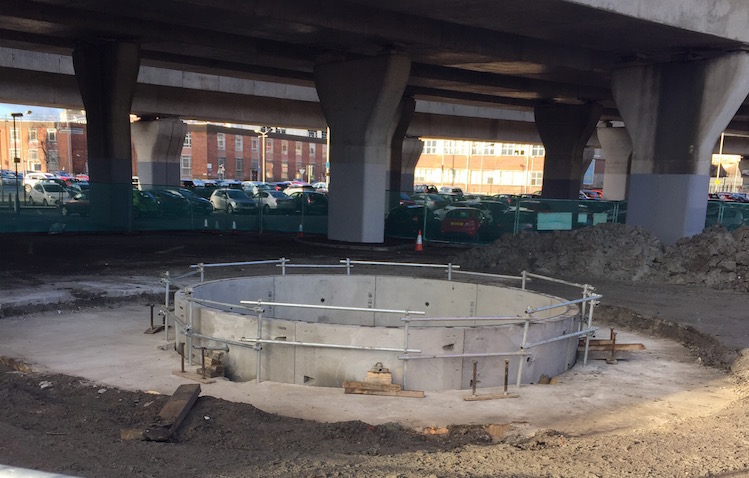 The top of a vertical shaft that
has been constructed for the "York Street
Interchange Advanced Works - Storm Chamber"
project that is currently underway in and around
the M3 flyover. Taken 10 Feb 2016 [Wesley
Johnston].
29 Jan 2016: The tender process to
appoint a contractor to build York Street
Interchange is currently underway. The first
phase (to create a shortlist of contractors that
will go on to phase 2) ended on 12 January but
phase 2 will take place out of the public eye.
These things take quite a while, so I don't
expect to hear of a contractor being appointed
until maybe mid 2016. In the meantime, however,
the DRD Minister mentioned the scheme in an
Assembly Written
Answer (AQW 52171/11-16) this week. She
confirmed what we know about the tender process,
and then added "It is anticipated that,
subject to successful completion of statutory
procedures and the necessary funding being
made available, the York Street Interchange
scheme will be ready to commence construction
in 2017/18." The reference to "successful
completion of statutory procedures" basically
means "assuming it passes the public inquiry"
that happened in November. I'm not anticipating
any difficulties in that regard. The second
reference, to "necessary funding being made
available" is a much bigger "if". Funding
allocations for the next five years were
unveiled by the Executive on 17 December made no
allocations at all for York Street interchange
for the period up to 2021. That does not rule
out money being made available - the 17 December
allocations were not the ONLY money that can be
made available for roads in the next five years,
so there is still hope that some money will come
through for York Street Interchange in that
period. In its favour is the fact that
this scheme will likely benefit from EU money to
quite a significant degree - assuming there
isn't a #Brexit in the meantime of course! In
August I said that the scheme could get underway
in late 2016 or 2017 if it was progressed at top
speed, but the Minister's statement is, I
think, more realistic in suggesting that it
could be ready to begin construction in 2017/18,
pretty much ruling out commencement later this
year. With a three year construction period,
that means the earliest possible completion date
with everything going like clockwork would be
mid 2020. The next two things to look out for
are (1) the Inspector completing his report of
the public inquiry (which will not be published
until a later date however) and (2) the
appointment of a contractor.
11 Dec 2015: In the update in September
(below) I noted that the DRD was issuing a
tender for a project called "York Street
Interchange Advanced Works - Storm Chamber",
which appears to involve the construction of an
underground drainage chamber adjacent to the M3
viaduct. To be clear, although this appears to
be required to facilitate the York Street
Interchange project, it's not part of the main
construction tender which has only just
commenced. A "storm chamber" is usually a large
underground chamber designed to hold water
running off a road or other surface in the event
of high rainfall to prevent it overwhelming
local water infrastructure. I do know also that
an arrangement has been reached with NI Water
that the drainage infrastructure to be built as
part of the York Street Interchange will also
take runoff from surrounding land too. So the
contract might be related to this. The
construction contract for the "Storm Chamber"
project was awarded
to "Terra Solutions Ltd" on 1 December. Terra
Solutions are a Newry-based firm
specialising in trenchless civil engineering
work. We will probably see evidence of this work
taking place within the York Street interchange
area over the coming months. The way in which it
was awarded suggests that the contract value is
probably below £1m.
23 Nov 2015: The Public Inquiry has now
ended, after lasting three days approximately
one week, plus some site visits. I
managed to attend a couple of hours of the
Inquiry out of personal interest - it was quite
a lively affair, and the transcript will make
for interesting reading in future years. Two
alternative proposals were put forward to the
Inspector, both claiming to offer fewer impacts
on the local area, which the Inspector will now
consider along with the more specific
objections. Meanwhile, some exciting news - the
initial phase of the construction
tender for the scheme commenced yesterday.
This is a two-phase process to appoint a
contractor. This first phase, which closes on 12
January 2016, is to allow contractors to express
interest in tendering for the scheme. Those who
appear to be credible enough to carry out the
work will then be invited to submit their actual
tender. This second phase will be done out of
public view, so after 12 January we will hear
nothing more until the announcement that a
contractor has been appointed, sometime later in
2016. The "contract duration" is given as 53
months, which is about four and a half years.
Since we know actual construction will only take
about three years, this presumably also
incorporates the advanced design phase. A few
points need to be stressed here. Firstly, this
does not in any way prejudge the public inquiry
- contracts like this are always worded in such
a way that there is a break between the
completion of design and actual construction, so
if the Executive or the DRD decide not to
proceed to construction, there is no contractual
problem. Secondly, even if a contractor is
appointed, construction will not take place
until the Executive funds the scheme. So it's
possible that - like has happened on the A6 from
Randalstown to Castledawson - that the
contractor could be appointed but no work
actually take place on the ground. The DRD seem
to be keen to begin work on the ground within 12
months - it remains to be seen whether the
Executive will provide funding to permit this.
9 Nov 2015: The Public Inquiry begins
tomorrow, 10th November in Assembly Buildings
Conference Centre, Fisherwick Place, Belfast BT1
6DW, starting at 10.00 am. Given the large scale
of this project and the number of issues it
raises I would expect it to last for a number of
days. It remains to be seen whether it will
attract much media interest. This will be the
sixth public inquiry in the history of the
Belfast Urban Motorway (which later evolved into
Westlink and the M3) - the previous five being
held in 1969, 1972, 1977, 1988 and 2000 - so
this scheme should be seen in its historical
context as a continuation of events of the past
fifty years, and not in isolation. (If you are
interested in the history of the Belfast Urban
Motorway can I humbly suggest my
book!) You can find out more about the
Public Inquiry and how to contribute here.
TransportNI has also recently published its procurement
update (basically a list of what it
intends to spend money on, and when) and this
again shows that the intention is to release the
tender for design and construction of this
scheme before December with a contractor to be
appointed by June 2016. This does not pre-empt
the Inquiry since most design and build
contracts like this one have clauses that allow
for the possibility that the scheme might not
proceed to construction. Potential contractors
were invited to an "open forum", organised by
TransportNI, on 23 September where (I assume)
contractors were able to ask questions of
TransportNI prior to the tendering process
opening.
8 Oct 2015: The pre-inquiry meeting
took place on Monday, 5 October to which all
objectors were invited (see previous update
below). It seems that only 33 objections were
received which, given the enormous impact of
this scheme on the locality, is really quite
remarkable. Of these, 20 related to provisions
for cyclists and pedestrians and 3 felt that the
A5 and/or A6 schemes should be prioritised.
Also, a dedicated
web site seems to have been set up for the
scheme featuring all the information about the
scheme and some videos. The DRD has re-launched
its own web site which looks very good, although
it does mean that most of the links from my site
to the DRD site are now broken!
14 Sep 2015: I continue to be astounded
by the rapid pace of work on this scheme, and I
am convinced now that it is one of the highest,
if not the highest, priority scheme within the
DRD. Information is
now being circulated about the public
inquiry which will take place from 10th November
2015 in Assembly Buildings, Fisherwick Place,
Belfast. It will be led by Mr Jim Robb, who has
chaired a number of recent public inquiries
including the various A6 schemes. A pre-inquiry
meeting is to be held from 10.30 am on 5th
October in the same venue. It seems that anyone
who wants to address the public inquiry is
expected to turn up at this pre-inquiry meeting
and also to supply a copy of all evidence that
they intend to give to the inquiry by this date.
This gives less than a month for any objectors
to write and submit their evidence. I am not
sure that objectors can be compelled to hand
their evidence over to the inquiry in this way,
but I can understand the Inspector's desire to
request this. In related news, a future tender
has appeared on the DRD
web site for what is called "York
Street Interchange Advanced Works - Storm
Chamber", which appears to involve the
construction of an underground drainage chamber
adjacent to the M3 viaduct. It is estimated to
be released for tender this month. It's not
clear why these works aren't bundled in with the
main construction tender, but it could be that
it is somehow critical to the schedule of works
and that having it constructed ahead of the main
scheme could speed things up. The DRD must be
very confident that the scheme will pass the
public inquiry if they are prepared to issue
tenders like this ahead of the inquiry! Finally,
the DRD Minister resigned last week, and has not
yet been replaced, so it is unclear now what
criteria DRD managers can use to decide what
progresses and when. However, speaking as
someone who has closely observed the road
construction programme over the past decade, I
have to say that if York Street Interchange were
to get funding before the scheme to dual the A6
from Randalstown to Castledawson then something
would definitely not be right.
18 Aug 2015: A "prior information
notice" about this scheme appeared on the European
Union's tender system ten days ago. This
is NOT an advertisement for tenders for the
scheme, but rather notice that such a tender
will be following. Think of it as a "heads up"
to the civil engineering community. It is pretty
obvious now that this scheme is being pushed
ahead as rapidly as possible within the DRD, and
indeed the DRD's own list of "future
tenders" suggests that the tender will be
released in November this year. Although the
public inquiry has not happened, this is not
pre-empting the inquiry since TransportNI has
moved to "Early Contractor Involvement"
contracts (see previous update below). The
"prior information notice" on the EU web site
suggests that the tender will be published on 16
November 2015 (although this may not be set in
stone). Astonishingly, it then goes on to
suggest a scheduled date for start of
construction as 1 July 2016! That would mean
seven and a half months for the entire tender
process, as well as carrying out the public
inquiry, writing the inspector's report and
dealing with any recommendations. So I am
somewhat skeptical that work could start as
quickly as that. However, the project completion
date given is December 2020, ie four and a half
years after the start of work. That, I think, is
more time than the project would really need (we
have been led to believe that construction will
take about three years) so this suggests that
these two dates are more the book-ends of a time
period during which construction would proceed,
but not necessarily taking that entire time
period. In December 2014 (see earlier updates
below) the official position was a start date in
2018, but that an "acceleration" was being
considered, and I think this is in fact the
case. Subject to the public inquiry, I think a
commencement date of late 2016 or 2017 is
possible if a rapid pace of work is maintained.
I still believe that the A6
Randalstown to Castledawson dualling scheme
will begin first (if it doesn't there's
something wrong) but I think that this scheme
may well be next in the queue after that. There
are interesting times ahead for lovers (or
otherwise) of urban motorways.
10 Jun 2015: The DRD
web site is now reporting that "Gateway 2"
for this scheme was approved by the TransportNI
on 14 May 2015. This is official speak for "OK,
let's prepare the contract documents". In the
past 3 or 4 years, TransportNI has moved to
"Early Contractor Involvement" contracts which
means that they involve contractors during the
design phases, and not waiting until all the
planning is done. This seems to lead to benefits
for everyone. So it makes sense to prepare the
contract documents now, even though the public
inquiry hasn't even happened yet (that's
starting 10 Nov 2015). The rapid progression of
timescales for this scheme reinforces my view
that this scheme is a very high priority within
TransportNI (I would now place it second in the
pecking order after the A6
Randalstown to Castledawson dualling scheme
which I still think will proceed next). The
scheme could well proceed to construction in
2018 as TransportNI seem to hope.
29 May 2015: It has now been revealed,
via the minutes
of a recent meeting, that the public
inquiry into the York Street interchange project
will begin on 10 November 2015. The same
minutes reveal that the DRD are seeking to
complete the project by 2021. With a
construction period of three years, this would
mean commencing work during 2018. This seems
just about feasible provided (i) the public
inquiry does not raise any serious problems (ii)
the process of appointing a contractor goes
smoothly and (iii) provided there is any cash to
actually build it in 2018. With the current
financial fiasco that is gripping Stormont,
especially after the events of the past week, it
is very far from certain whether this will be
the case. If the financial empasse is not
resolved, we could be looking at very deep cuts
to the DRD in the next 2 or 3 years which in a
worst-case scenario could mean no money at all
for road improvement schemes.
25 Mar 2015: The public exhibition took
place in February as discussed below, and this
included an incredible 3D model of the proposed
junction which the public were able to see - see
picture below. The DRD Minister today announced
that there will be a public inquiry. This is
interesting not because there will be an inquiry
(an inquiry was inevitable) but because it's
come so rapidly after the end of the
consultation period, which ended just 15 days
ago. This rapid movement to the next stage
suggests that this scheme is a high priority
within TransportNI and that they are keen to
keep the ball rolling. The press release
indicates that the inquiry will likely be held
in "late autumn 2015", which we could take to
mean November. This scheme will mark another
chapter in the long-running history of what
began life in the 60s as the Belfast
Urban Motorway. Its highly sensitive
location close to the city centre means that the
inquiry will have to consider a very wide range
of issues. If the pace of work continues, and if
the Dept of Finance comes up with the necessary
funding, work could be underway within three
years.
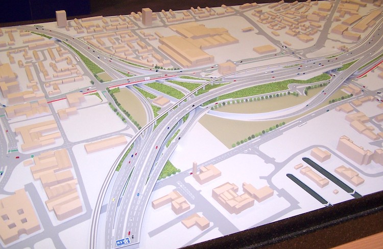
Model of TransportNI's proposed York Street
junction on display, 10 Feb 2015. The tan colour
on some of the ground around the junction
indicates land that could be released for
development, while green coloured land would
remain owned by TransportNI. Thank you to the
folks at TransportNI who facilitated me taking
this photo. [Wesley Johnston]
27 Jan 2015: The DRD Minister
today announced
that the draft legal orders for this scheme have
now
been published. These are the three legal
documents required before a new road can be
built. They are: the Designation Order
(detailing where the new trunk road is to run),
the Environmental Statement (a weighty tome that
makes the case for the road and details its
impacts) and the Vesting Order (which compels
landowners to sell the land required for the
road). These documents are "draft" at this stage
in the sense that the scheme is still being
planned. These documents will form the basis of
the Public Inquiry which will certainly have to
be held. Before the Public Inquiry, however,
there is a public consultation to gauge public
opinion and invite comments or objections, and
that is what today's announcement is setting in
motion. The consultation period will run from 28
January until 10 March. The Minister said in his
press release that "I would encourage
everyone who cares about the development of
our road infrastructure to get involved and
take part in the public consultation process",
a sentiment with which I wholeheartedly agree
and echo, especially given the scale of these
proposals. To assist the public a new document,
the Stage 3 Assessment Report, has
just been published on the DRD web site
which incorporates the Environmental Statement.
The other
two draft legal orders are there too.
There is a lot of material to digest here and I
have not yet read it myself! The only comment of
note to make now is that the cost has been
revised up to £125-165m which is quite an
increase on the cost of £100-135m that was
estimated in December 2012. The press release
also clarifies that construction would take
roughly three years. There will be a public
exhibition in the Ramada Encore hotel in
Belfast city centre, where a scale model and
computer generated graphics of the scheme will
be on display. The exhibition will be open on
Monday 9 February from 2pm to 9pm and
Tuesday 10 February from 10am to 9pm.
18 Dec 2014: The Minister was
asked about this scheme in
the Assembly last week. In my update 12
days ago I noted that we have not yet had
publication of the draft legal orders, and so it
is timely the Minister said that this would
happen "during the current financial year",
which we can take to mean by April 2015. This
would almost certainly be followed by a public
inquiry. He reiterated the view that
construction on the scheme could get underway
"in 2018" subject to finance and would take
three years to build. This would see the
junction completed in 2021. This is a
challenging timescale, but I believe do-able if
everything moves at peak efficiency. The biggest
caveat is probably funding - with increasing
austerity the scheme may well reach the point of
being shovel-ready but not commence due to lack
of funds. It would also be a brave Minister
indeed who would announce funding for this
scheme ahead of any more work on the A6 (the
road to Derry)! Meanwhile, in a question
for Written Answer published a fortnight
ago, the Minister said that "is expected
that the vesting of land for the project will
commence early in 2015". It remains to be
seen how realistic this is, given that the
Vesting Order has not even been published yet
and that the scheme may well need a public
inquiry. One advantage is that the DRD already
owns some of the land needed, eg the car park
mentioned in the question, and also their
own TransportNI section office which will
have to be demolished.
6 Dec 2014: According to the minutes of
a TransportNI board meeting held on 1 October
(but just
published) this scheme continues to
progress rapidly. The minutes state that "the
current programme envisages an early 2018
start date, however, acceleration of the
project is being considered". Given that
we have not even had publication of the
Environmental Statement, let alone a public
inquiry, starting construction in early 2018
would require a constant pace of work from now,
while accelerating the programme would be
challenging. For example, the type of large
cranes needed require up to 12 months' notice
before being installed. Nevertheless, this
comment implies that TransportNI now regard this
as one of the most important road schemes in the
planning stages.
7 Jun 2014: Back in mid May the DRD released
their vision for the future of investment in
railways over the next 20 years. The plan
includes a scheme to widen the Dargan Viaduct in
Belfast from one to two lanes. This is the
stretch of railway that runs overhead beside the
M3 motorway connecting the Larne railway line to
the Bangor railway line, and which opened at the
same time as the M3 in 1995. This document
implies that this work will take place at the
same time as (perhaps even in the same contract
as) the York Street junction upgrade. The
document says "The track dualling is expected
to coincide with the Department’s plans to
upgrade the Westlink - York Road - M2 road
junction, also a bottleneck on the TEN-T Core
Corridor." This is yet another example of
how the York Street junction upgrade will
benefit literally all forms of transport in the
city: as well as improving journeys for
vehicles, it will allow the reclamation of the
local streets for walking, cycling and bus
priority infrastructure. Trains are now added to
the list of beneficiaries.
4 Dec 2013: Preparation work on this
scheme continues to move forward, strongly
suggesting that this scheme is considered a high
priority within Roads Service. After the
announcement of the preferred option almost
exactly a year ago, detailed design work on this
option has been progressing. The DRD's own
web site is saying that work is also
taking place on the suite of documents that are
required before the scheme can move to the
public inquiry stage (the Environmental
Statement and draft legal orders) and that these
are expected to be ready by "late 2014". If
Roads Service keep pushing this scheme we could
conceivably see a public inquiry taking place in
2015. A public inquiry and follow-up work can
take perhaps a year, and procurement a further 9
months, so in a best case scenario (ie where
there are no unforeseen delays and the Executive
makes money available straight away) we could
see construction getting underway during 2017.
This is my speculation, however: Roads Service
have not committed to a timescale.
11 Mar 2013: A Ground Investigation
contract got underway on 21 January (according
to these
meeting minutes) the purpose of which will
be to find out exactly what is lurking under the
ground at the site of this proposed junction
upgrade. This will allow a more detailed design
to be undertaken, for example, determining
precisely what amount and type of piling will be
required in each location. I am getting the
impression that this scheme is a high priority
within Roads Service. The recently-agreed Investment
Strategy for Northern Ireland suggests
that after the current round of projects (A5WTC,
A8 Larne and A2 Greenisland) the focus will move
to the M2, A6 and A26, with a
possibility of using what is calls "alternative
finance", perhaps some kind of public/private
partnership. The reference to "M2" could only
refer to the York Street scheme. Therefore, I
think we will see things move rapidly on this
scheme (or as rapidly as major infrastructure
schemes can move, at any rate!).
6 Dec 2012: The announcement of the
preferred option for this junction was made this
morning. The speculation two days ago (see
below) was incorrect, and in fact Roads Service
have selected Option C, the fully
grade-separated underpass option. There will
be no 18 metre flyover at York Street. I
have included a screen shot of Option C towards
the top of this page, along with some initial
observations of the design from a road user's
point of view. However, I must take my 'neutral'
hat off at this point and add that this is the best
decision Roads Service could possibly have
made, as the option they have chosen is a
win-win for everyone. This option not only gives
fully free flowing links to the busiest
signalised junction on the road network, and
increases its capacity, but will also take a lot
of traffic down out of sight below ground level,
and will reduce traffic levels significantly on
surface streets, potentially allowing schemes to
increase public transport / cycling / pedestrian
use of these spaces, and also to allow the
commercial redevelopment of these streets. The
folks at the Forum for
Alternative Belfast have developed a commendable
plan of how this could be achieved without
sacrificing the benefits of the scheme by using
Option C as the starting point. I do note that
the cost estimate has gone up from £98m (as of
2011) to the range £100m-£135m. This cost creep
has been a feature of many road schemes here in
recent years. For those who are really
interested, there are about 1,200 pages of
technical drawings and reports available
here. You'll find everything from possible
sites for cranes to the locations of the drains.
The main drawing of the chosen option is here.
Happy reading! I will make more detailed
comments over on my blog in a week or two once
I've had a change to digest this huge report. We
should also thank Roads Service for making the
report available in such a usable format online.
4 Dec 2012: Further to the previous
update, it is now known that the announcement of
the preferred option for this scheme will be on
Thursday morning, 6th December. The folks at PLACE
seem to have information suggesting that the
preferred option is Option B (see all
four options here, and in the table
above). However, this has not been verified by
Roads Service. Under Option B all four moments
between the Westlink and M2 / M3 would be
freeflowing which would be excellent given that
two of the options had one signalised
connection. The most controversial element of
Option B is undoubtedly the 18 metre flyover
over the M3 and railway viaducts which is
proposed to take the M2->Westlink movement.
We will have to wait until Thursday to see if
this speculation is correct.
1 Dec 2012: There are rumours that there
will be some kind of announcement concerning
this scheme before Christmas. As I said in the
last update, Roads Service have probably
selected a preferred option by now, so any
announcement would be likely to relate to this.
However, we will have to wait and see what
happens. Roads Service were selecting from four
preliminary options, as described above. Watch
this space.
24 Oct 2012: It has been 16 months since
the last update, with nothing further published.
However, the DRD web site has just been updated
to say that the "Stage 2 Report" was "presented
to Roads Service Board October 2012." This
report does not seem to have been published
online, but it is likely to contain a refinement
of the four preliminary options detailed in June
last year, probably containing more accurate
designs and costings, and probably making a
specific recommendation about the preferred
option. Hopefully it will be released soon - but
Roads Service have not publicised a timetable of
milestones for this scheme, so we do not know
when this might happen.
5 June 2011: Roads Service
and designers Scott Wilson held their exhibition
last week which included four excellent 3D
animations of the new junction which I hope
appear online at some point. You can see
some stills on the BBC web site. They gave
out leaflets (downloadable
here) and questionnaires and spoke to
members of the public and presented four options
which I have summarised in a table above. Only
options B and C are fully freeflow. Options B
and D feature a bridge over the existing M2,
which would be a significant structure at 18
metres above ground level, but not entirely out
of keeping with the area. It was pointed out at
the consultation that the flyovers allow gentler
curves and more coinsistent speeds than the
underpass option. The underpass is less visually
intrusive, but more challenging as it has to go
between the pillars of the M3 and Dargan Railway
Bridges which were not designed with this in
mind. Since this upgrade will almost certainly
be the last major project to be carried out on
this junction for several decades, it would seem
very shortsighted indeed to go anything short of
a fully freeflow design – ie options B and C are
the only viable options in my view. In terms of
timescale, no money has yet been allocated so
there is no construction date other than the
more general "by 2018" that was quoted in 2008.
14 May 2011: Roads Service
will be holding a Public Exhibition of their
current proposals on 1 and 2 June 2011, in the
Ramada Encore Hotel, St Anne's Square, Belfast.
On the 1st the event will run from 2pm to 9pm,
and on the 2nd it will run from 10am to 9pm. Full
details here. The event will be detailing
the current route options, which are probably
going to be refined versions of those in the
2009 Preliminary Options Report (see previous
update). I would urge all those with an interest
in the scheme to turn up as this is a pivotal
junction, the meeting points of the three
busiest roads in Northern Ireland.
12 Mar 2010: This update is
purely to draw your attention to the fact that
the Preliminary Options Report of March 2009 is
available online here
(links on right of the page). It goes into
incredible detail with maps of everything from
the gas mains to traffic signal wiring. It also
shows 3D computer generated diagams of the route
options (Figures in Section 4). Four of the six
options considered have been brought forward for
further consideration. I have added links to
maps of these four options to the text above -
just click the thumbnail images.
6 July 2009: In one
of these written answers in the Assembly
from mid June, the Minister publicly
re-confirmed Roads Service's intention to
proceed with the scheme, and also accepted what
they and everyone else already knew which is
that "the completion of the M2 Improvements
and the M1/Westlink Schemes has resulted in
traffic now being delivered much more quickly
to the Nelson Street off slip and York Street
junction" and that "this has resulted
in increased pressure on this part of the road
network". The need for this final part of
the jigsaw is now self-evident to motorists.
Finally, they confirmed that the work which
began in June at the York Street end of the
Westlink is an "interim measure" and
involves "widening the M2 bound carriageway
of the Westlink, to provide a dedicated left
turn lane to York Street, and extending the
length of the existing M3 bound lane."
16 May 2009: According to the
minutes
of a Roads Service board meeting at the
end of March 2009, the Preliminary Options
report has now been completed (although not
published publicly). The board has now granted
"gateway 0" approval. In laymans language, this
means that the scheme has been approved, in
principle, and they will now proceed to develop
more detailed options. Also, an Order
comes into force on 22 June 2009 which will
result in Henry
Street being stopped up at York Street.
This is a residential street that currently
joins York Street at a T-junction between the
Cityside Shopping Centre and the Westlink (with
barriers
to prevent its use as a rat run). It may be
completely unrelated, but it is worth noting
that stopping up this junction will make the
design of the new York Street interchange much
easier.
11 Apr 2009: Speaking to a
member of Roads Service, it seems that Roads
Service are currently considering a number of
possible options for the design of this
junction, and that the model pictured above is
of just one of these. The options being
considered include layouts going over the top of
the M3 flyover, and ones that involve going
below ground level. Some kind of announcement is
likely within the next year or so. It is likely
that public pressure will encourage this scheme,
since the completion of the Westlink and M2
schemes are likely to result in increased
congestion at this junction from 2009 and
onwards. Construction is currently timetabled
for the period 2014-2018.
9 May 2008: At last, the
scheme has been given the go-ahead. The document
"Investment Delivery Plan For Roads", published
in April 2008, includes the plan in the "forward
planning schedule" for schemes where permission
has been granted to proceed with design and
consultation work. Construction is timetabled
for the period between 2013 and 2018, but this
is an approximate period.
26 Mar 2008:
No announcement was made last May as
indicated. However, the scheme is very much on
the cards. Two developments suggest this is the
case:
- An area of land to the east of Nelson Street
(beside the former "Clarendon Square"
development) was fenced off in the past year
and has apparently been purchased with this
scheme in mind - for the M2->Westlink
sliproad.
- On 28 November 2007 the Regional Development
Minister committed
to the scheme, although referring to it
as a "longer term" proposal. Nevertheless, he
announced that a consultancy firm would be
appointed "in the next few weeks" and that
they "expect that this proposal will cost
around £50 million".
Further calls were made
in March 2008 by the IEC-CBI Joint Business
Council for this scheme to proceed. They argue
that "It is crucial to ensure that an
efficient freight and logistics system is in
place on both sides of the border, in time and
with sufficient capacity to encourage rather
than to constrain expected economic growth."
Mar 2007: It is thought that
the Roads Service are actively pursuing this
scheme and currently it seems as if some kind of
announcement will be made in May 2007 giving
more details about what is proposed.
Construction dates are unknown, but traffic
congestion will likely make it a priority. I
would be surprised if the completed junction was
not in place by 2015 at the latest.
Photos
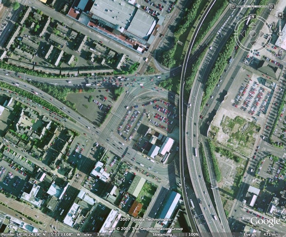
Google Earth image
dating from the mid 2000s showing the area in
question. The M2 is to the top right, the M3 to
the bottom right and the A12 Westlink to the
left. York Street runs diagonally from top
centre to bottom left. The city centre is below
the image and the Port of Belfast is to beyond
the top right of the picture. [Picture from
Google Earth]
Historical Image
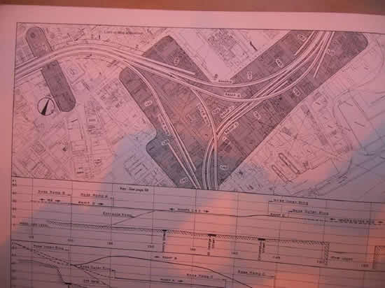
The
proposed scheme is reminiscent of this three-way
freeflow junction proposed for the same site
back in 1967 which would have connected the M2
to the two arms of the Belfast Urban Motorway
(constructed as A12 Westlink and M3). Full
size image. See link at top of page for
more details.
|


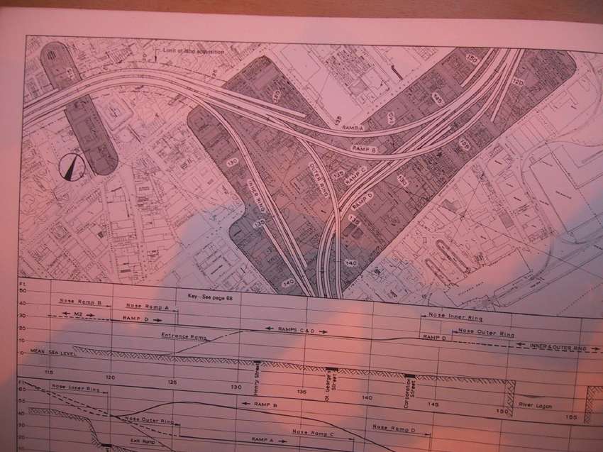