|
|
Status
|
Planned road (to be
constructed in phases) |
|
Where
|
To
upgrade the entire A5 to
dual-carriageway from the Irish border
near Aughnacloy, via Omagh and Strabane,
to Derry. |
|
Total
Length
|
93.6 km / 58.2
miles |
|
Dates
|
17 Jul 2007 - NI
Executive agrees to proceed with the
plan
14 Nov 2007 -
Consultants appointed to select
preferred route
7 Nov 2008 -
Preferred route corridor [not exact
route] announced
Feb 2009 - Route
options displayed to the public
21 July 2009 -
Preferred route announced
Nov 2010 - Pre-orders
Exhibition and draft statutory orders
published
9 May to 1 July
2011 - Public Inquiries held
9 Nov 2011 - Irish government withdraws
funding offer (officially on 10th)
Late 2011 - Inspector due to submit
Reports into Public Inquiries
14 Feb 2012 -
Decision to proceed with Derry-Strabane
& Omagh-Ballygawley by the end of
2012.
Mar 2012 - Reports into Public Inquiries
given to DRD
31 July 2012 - Scheme passes public
inquiry with some amendments
Sep/Oct 2012 -
Construction of two stretches was to
have begun (as of Feb 2012 - changed
from
"2016" as of Nov 2011; and "2012" as
of Feb 2009)
10 Sep 2012 - Legal
challenge received, and scheme put on
hold
12 Mar 2013 - Judge upholds one of the
legal challenges
8 Apr 2013 - Judge quashes decision to
proceed with scheme
April 2014 - Public consultation on 3
Habitats Directive assessments
Oct 2014 - Public consultation on Tully
Bog Habitats Directive assessment
16 Feb 2016 - Amended
Environmental Statement published and 6
week consultation began
18 Apr 2016 - Revised
Summary of Environmental Statement
published for 6 weeks consultation
25 Aug 2016 - Legal
challenge received (application for a
judicial review)
4 Oct 2016 - Public
inquiry began
30 Nov 2016 - Legal challenge rejected
by judge
28 Nov 2017 - Scheme
given go ahead by DFI, and public
inquiry report published
22 Dec 2017 - Third
legal challenge received
Dec 2018 - DFI concedes legal challenge.
Judge quashes decision to proceed with
scheme.
18 Feb 2020 - Third
public inquiry began (into additional
environmental documents), later
adjourned
15 May 2023 - Third public inquiry
re-convened
31 Oct 2023 - Report
into public inquiry given to DFI
20 Feb 2024 - Irish
government increases funding to €600m
(£514m).
2 Oct 2024 - DFI
announces decision to proceed with south
of Strabane to Ballygawley section
13 Nov 2024 - Legal challenge received
18 Mar 2025 - Legal
challenge gets underway in court
23 Jun 2025 - Judge
upholds three of the legal challenges,
quashes decision to proceed with scheme
6 Aug 2025 - DFI launch appeal to the
court ruling
9-11 Dec 2025 - Appeal hearing
|
|
Cost
|
£2.1bn as of Oct 2024
(changed from £1.7bn as of Feb 2024;
changed from £1.609bn as of Nov 2022;
£1134m as of Dec 2019; £1049m as of
Oct 2016; £844m as of Aug 2009;
£650-850m as of Nov 2008; £560m as of
2007) with costs broken down as
below in 2019:
---£207m for Newbuildings to N of
Strabane (as of 2019 changed from £150m
as of Oct 2016)
---£499m for N of
Strabane to S of Omagh (as of 2019
changed from £495m as of Oct 2016)
---£270m for S of Omagh to Ballygawley
(as of 2019 changed from £225m as of Mar
2016; changed from £160m as of Feb 2012)
---£158m for
Ballygawley to border Aughnacloy (as of
2019 changed from £107m as of Oct 2016)
Irish government was
to have contributed £400m to this scheme
and the A8 upgrade. However, this was
then reduced to £75m plus £25m in
2023/24 if the scheme is approved =
£100m. This was then increased once
again to €600m (£514m) in January 2024.
|
|
Contractors
|
Section 1
(Newbuildings to south of Strabane) -
BAM, Balfour Beatty, FP McCann, ARUP,
Atkins.
Section 2
(South of Strabane to south of Omagh) -
Sisk, Roadbridge, PT McWilliams, Fehily
Timoney Gifford.
Section 3
(South of Omagh to Aughnacloy) - Graham,
Farrans, Scott Wilson, Halcrow.
|
|
See
Also
|
Official
web site on scheme - A5WTC
General
area
map
Strabane
Lifford Link Road on this site
We
Support the A5 - Facebook group
supporting the scheme
|
Click here to jump straight
down to updates for this scheme
NOTE:
In light of the way this scheme is now
being broken into phases, I am turning this
page into a general page about the overall
plan for the A5, and producing separate pages
to track construction of each phase. Hence you
can visit:
- A5 dualling South
of Strabane to South of Omagh - on
this site
- A5 dualling
South of Omagh to Ballygawley - on
this site
The
Plan
This ambitious road
scheme, which was originally to be progressed
thanks partly to £400m of the necessary funds
being made available by the Republic of Ireland,
would have been the single largest road scheme
ever undertaken in Northern Ireland. The
original plan, as of 2007, was to convert the
entire 55 mile A5 to a high-quality
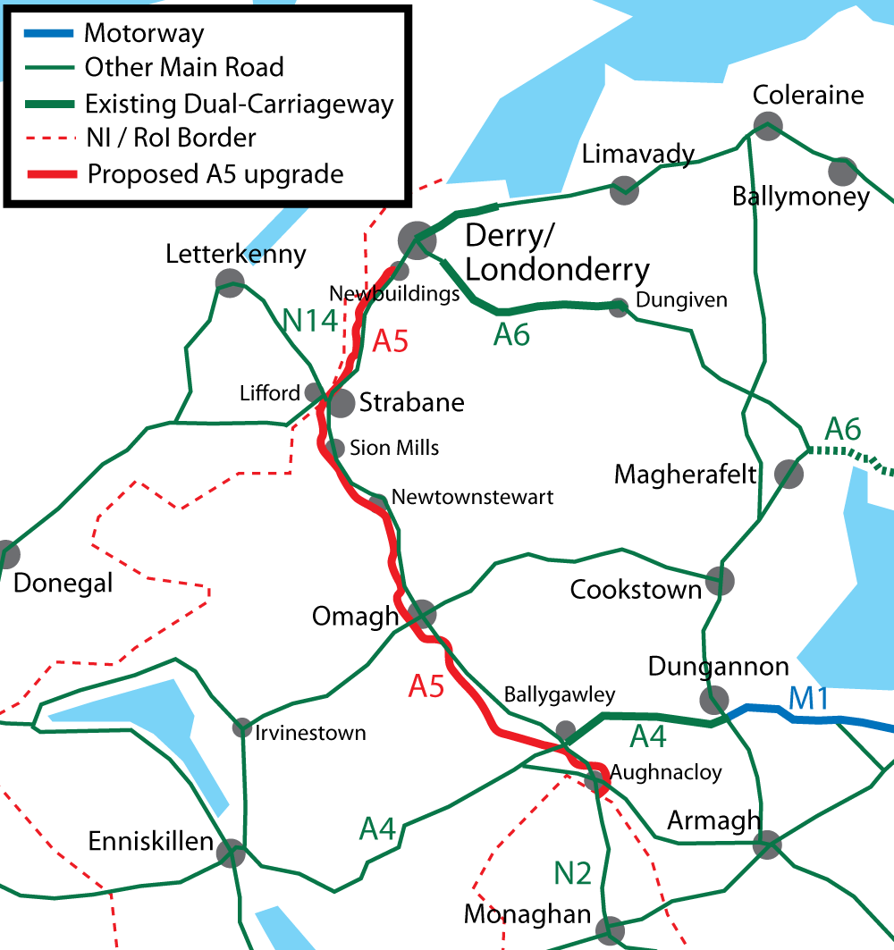
dual-carriageway. The A5 is the main north-south
route in the west of the province connecting the
A4/M1 route which runs across the south of the
province to the A6 route which runs across the
north. It serves the principal towns of Omagh
and Strabane along the way, as well as
terminating in Londonderry city. From an
all-Ireland perspective the A5 is an extension
of the Irish N2 road, the main route from Dublin
to Derry and Donegal. The map below shows the
existing A5. In November 2011 Dublin announced
that its contribution would be delayed. Hence in
February 2012 it was decided to break the
project up and build it in phases. See links
above.
The standard of the
proposed road is very high (technical term is
"Category 6"). It will consist of two 7.3 metre
carriageways with 1 metre hard strips on either
side and a 2.5 metre crash barrier, as shown
below. The central reservation will be
continuous, ie there will be no right-turns.
This means that all junctions will be either
grade separated, be limited to left-in/left-out
movements only, or be at-grade roundabouts.
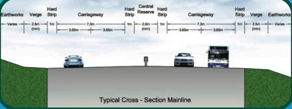
Image
clipped from a PDF on the A5WTC
site at
this location.
Route
The
most detailed route maps are downloadable
from
the A5WTC site, and scrolling down to the
bottom and looking for the 2016 Brochures.
Junctions on the new road are a mixture of
full-scale grade-separated junctions (like
proper motorway junctions), compact
grade-separated junctions (such as have been
built recently on the A1) and ordinary
roundabouts. The strip map below shows the
various junctions proposed. The numbers are as
given in a document released in November 2010,
but are probably for reference only.
Interestingly, the proposed road will set a new
record for the longest stretch of
dual-carriageway/motorway with no junctions in
Northern Ireland: the 14.6 km/9.1 mile stretch
between Seskinore and Ballygawley.
|
NORTH
Begins
as A5 Victoria Road, Newbuildings
(approx
2 miles / 4 km south of
Londonderry)
|
|
Junction 1:
Newbuildings North
|
|
|
B?? Victoria Road
(current A5)
|
|
1
lane each way – 1.3 km /
0.8 miles
|
|
Junction 2:
Newbuildings South |
.
|
|
Link road to B??
(current A5)
|
| |
13.0 km / 8.1 miles
|
|
Junction 3:
Ballymagorry
(Strabane north)
|
|
|
B?? (current
A5)
B49
Berryhill Road
B?? (current A5)
into Strabane
|
| |
2.9 km / 1.8 miles
|
|
Junction 4 / 5:
Lifford Road / Railway Street
(Strabane centre)
Access to/from the
north only.
|
Access to Park Road
.
A38
Lifford Road
|
|
B?? (Current A5)
Railway Street
(town centre)
B??
(Current A5)
|
| |
0.5 km / 0.3 miles
|
|
Junction 6:
Bradley Way
(Strabane centre)
Access
to/from the south only.
|
|
|
B?? (Current A5)
Bradley Way
(town centre)
B??
(Current A5)
|
| |
1.3 km / 0.8 miles
|
|
Junction 7:
N14/N15 link
(Strabane)
No access to local
road network.
A5
turns at 90° via roundabout.
|
Proposed link
to
N14/N15 in
Donegal
(see
here)
|
|
|
| |
2.6 km / 1.6 miles
|
|
Junction 8:
(Strabane South)
|
|
|
B?? (Current A5)
into Strabane
B?? (Current A5)
into Sion Mills
|
| |
|
Junction 9:
Victoria Bridge |
|
|
B72 Fyfin Road
into Victoria Bridge
|
| |
5.8 km / 3.6 miles
|
|
Junction 10:
Newtownstewart
|
Drumlegagh
Road North
B84 Baronscourt Road
.
|
|
B84 Baronscourt Road
into Newtownstewart
|
| |
12.0 km / 7.4 miles
|
|
Junction 11:
Omagh North
|
|
|
B?? (Current A5)
Beltany Road
A??
(Current A5)
Beltany Road
Into Omagh
|
| |
5.7 km / 3.5 miles
|
|
Junction 12:
Omagh West
|
A32 Clanabogan
Road
("Dromore Road")
towards
Enniskillen
|
|
A32 Clanabogan Road
("Dromore Road")
into Omagh
|
| |
4.0 km / 2.5 miles
|
|
Junction 13:
Omagh South
|
B83 Seskinore
Road
|
|
A?? Doogary Road
(Current A5)
into Omagh
B?? (Current A5)
|
| |
6.7 km / 4.2 miles
|
|
Junction 14:
Moylagh
(Seskinore)
|
B46 Moylagh Road
into
Seskinore
Augherpoint
Road
|
|
B46
Moylagh Road |
| |
14.6 km / 9.1 miles
|
|
Junction 15:
Ballygawley
|
A4 Annaghilla Road
towards
Enniskillen
|
|
Tullybryan Road
A4
dual-carriageway
towards
Belfast
.
|
| |
4.9 km / 3.0 miles
|
|
Junction 16:
Aughnacloy North
Access
to/from the north only.
|
B?? (Current A5)
Tullyvar Road
into Aughnacloy
|
|
B?? (Current
A5)
Loughans Road
|
| |
3.5 km / 2.2 miles
|
|
Junction 17:
Aughnacloy East
|
Caledon Road
into Aughnacloy)
|
|
A28 Caledon Road
towards Armagh
|
| |
1
lane each way – 1.5 km /
0.9 miles
REPUBLIC OF
IRELAND BORDER
Continues
as N2 to Dublin
SOUTH
|
Updates
8 Jul 2026: According to a Written
Answer in the Assembly (AQO 3825/22-27) in
June, the Court of Appeal hearing for the
section o road south of Strabane concluded in
June. So we are now awaiting their ruling, which
could take a few months to come. For DFI a huge
amount hinges on this appeal. If they lose the
appeal, the entire road building programme is in
jeopardy (as well as construction projects by
other departments such as Health and Education)
and the A5 will almost certainkly not happen in
its current form. If they win, then they can
return to something close to how they have been
operating in the past and the A5 scheme is much
more secure. In a separate Written
Answer (AQW 47546/22-27), the DFI Minister
confirmed that DFI has so far spent £192.6m on
the A5 project. (To put that in some kind of
perspective, the total cost of the A6
Derry-Dungiven dualling scheme completed in 2023
was approx £250m.) The public consultation on
the possible alternative routes around Strabane
(see below) closed yesterday so that is back in
DFI's court.
7 Jun 2026: On 28 May 2026 DFI issued
new route options for Section 1 (Newbuildings to
South of Strabane). Although the route here was
decided back in 2009, DFI Roads are looking
again at the route options for this section
because the previously preferred route is now
being reviewed in light of the passage of time
and the findings of the 2023 Public Inquiry
Report. That report was critical of the way the
current route traverses the flood plain and
recommended that alternative route options be
assessed, so DFI is carrying out fresh
engagement and design work before confirming a
preferred route for the Newbuildings to south of
Strabane section. The options being considered
are accessible
here, but I also include a copy of the map
below. The white line shows the 2009
route that the Inquiry report criticised.
However, it is important to note that the white
line is still a route option this time round.
The other options all take the route out of the
floodplain to a greater or lesser degree. All
new options pass around the east of Strabane. A
few of observations, in no particular order:
- This is not related to DFI's legal challenge
to the court ruling against the scheme. This
is a separate line of work that assumes that
the road will go ahead.
- There is no guarantee that DFI will choose
one of the alternative routes. They may
conclude that the white 2009 route remains the
best route. The flood plain is only one of
many considerations, some of which conflict
with each other.
- If the 2009 route is not chosen,
then access to the new TEN-T scheme in Donegal
at Lifford will be via the southernmost
section of the existing Strabane Bypass, part
of which would need upgraded to match the
dual-carriageway standard that would then
exist at either end.
- If the 2009 route is not chosen, then there
would no longer be a dual-carriageway between
Strabane town and the Mourne river.
- The routes round the east of Strabane are
all confined by the existence of a very narrow
gap between the Sperrin AONB and Strabane Glen
ASSI. There is no route through west Tyrone
that passes far from all sensitive sites.
You can
respond to the consultation until 7 July
2026.
New route options for Section 1
(Newbuildings to South of Strabane) released on
28 May 2026 [DFI Roads]
6 May 2026: Two developments to report
(neither is the ongoing appeal to the legal
ruling against the scheme, sorry). Firstly,
in
April DFI "appointed Jacobs UK Ltd as
technical advisors to take forward design and
assessment work on improvement options on
Section 3 Phase 3". This refers to the
short southernmost section from Ballygawley to
Aughnacloy, the route of which was criticised as
'premature' by the Planning Appeals Commission
in 2024 given low traffic levels and the lack of
a plan to dual the N2 on the Monaghan side of
the border. Given that the Irish government is
now progressing a plan to dual the N2 in
Monaghan, DFI have decided to take this section
back to an earlier stage of planning where they
will now go back and look afresh at route
options. This will add several years and
probably another public inquiry to this section,
but given that there is zero chance of it going
ahead in the next ten years anyway, this doesn't
really matter. Secondly, DFI announced
yesterday that the same thing is happening
with the section between Newbuildings and
Strabane. As a reminder, the Planning Appeals
Commission rejected the design of this section
as breaching the law on flooding. As a result
DFI decided not to progress this section
immediately, and said they would approach the
problem in two ways: firstly, by looking for
additional land on the Donegal side of the Foyle
to engineer to form replacement flood capacity,
and secondly to reconsider the route to take it
further from the floodplain. This development
refers to the second of these, but doesn't
necessarily mean the former option has been
ruled out. The route options that are now being
considered will be made public at exhibitions to
be held Wednesday 27 May 2026, from 11:00 am to
8:30 pm at the Fir Trees Hotel, Dublin Road,
Strabane BT82 9EA and on Thursday 28 May 2026,
from 11:00 am to 8:30 pm at the Everglades
Hotel, Prehen Road, Derry, BT47 2NH. What will
be particularly interesting is to see whether
DFI is considering a route round the east side
of Strabane, away from the river, and whether a
route that passes into Donegal has been, or even
can be, considered.
11 Feb 2026: According to a Question
for Written Answer, the High Court is to
hold a hearing on 25 February 2026 to hear
additional arguments around section 52 of the
Climate Change Act, after which the matter will
be referred back to the Court of Appeal to
resume their hearing on the appeal (see previous
update for details). The whole thing is taking a
very long time. The DFI Minister, Liz Kimmins,
seems to have decided that all road schemes need
to be paused pending the outcome of this case,
though as yet I have not heard a compelling
reason why this needs to be so, particularly
concerning the A4
Enniskillen Bypass which I understand is
not vulnerable to legal challenge at this point
due to its advanced stage. Anyway, this means
that the A4 Enniskillen Bypass, the A1 Junctions
Phase 2 project and the Lagan Footbrige
project will all remain "on hold" at least until
the Appeal ruling is given. The Minister
clarified that this will not result in the loss
of these projects, saying "To preserve the
progress already made, I have ensured these
schemes can remain live until the final
judgment is delivered through the extension of
the tender validity periods for both the A4
Enniskillen Bypass and the Lagan and
Pedestrian Cycle Bridge. My officials are also
preparing options for my consideration to
protect the A1 Junctions Phase 2 project".
Given that the Court of Appeal has yet to
reconvene, I can't see anything happening on any
of these projects for a while yet.
10 Dec 2025: The Court of Appeal began
hearing DFI’s challenge to the June ruling
that blocked the £1.7bn A5 scheme. However, one
central part of the appeal, concerning section
52 of the Climate Change Act, could not proceed
as planned. This was because DAERA, which was
not involved in the original High Court case,
now wishes to raise new arguments. The Lady
Chief Justice noted that no explanation had been
given for why these points were not presented
earlier, so the Court of Appeal has sent this
element back to the original High Court judge,
who will consider it on Monday. The remainder of
the appeal is continuing however. In the main
hearing, the court focused on the greenhouse gas
methodology used in the A5 Environmental Impact
Assessment. The High Court had ruled that
further consultation was required on how induced
traffic emissions were estimated. DFI are
arguing that the judge was wrong, saying the
department had assessed these effects, which
includes cross-border traffic, and that any
induced traffic would be minimal. However the
Alternative A5 Alliance maintained that the
carbon-budget 'headroom' is tight and the true
impact is uncertain. The court also began
hearing submissions on human rights, with DFI
contesting the ruling that assessments had not
been carried out. The appeal is scheduled for
three days, i.e. up to Thursday 11th, with
Friends of the Earth and A5 Enough is Enough
also participating. The judge will probably wait
a few weeks after the hearing to reach and give
her ruling.
8 Oct 2025: DFI Minister Liz Kimmins
put out a press
release two weeks ago reaffirming her
commitment to the A5. In it she said that their
appeal to the 23 June court ruling against the
scheme will be heard during December
2025. The judge will probably not issue a ruling
immediately but, like last time, will probably
take some time to consider the arguments of both
sides before making a ruling. The outcome,
therefore, may not be known until the late
winter or early spring. The future
direction not only of this scheme, but all road
schemes here, will be affected by the outcome of
this appeal so DFI will be putting all their
resources into it. The only piece of news is
that, in a Written
Answer answered at the end of September,
the Minister confirmed that "a cross-border
working group has now been established to
reinforce collaboration on the continued
development of the N2 Clontibret to border
Road Scheme and Phase 3 of the A5, from
Ballygawley to the border". This refers to
Phase 3 of the A5 project which will run
from Ballygawley to the ROI border at
Aughnacloy. The authorities in Monaghan are
planning an upgrade of the N2 from there to
Clontibret, so this sort of collaboration is
essential to ensure both sides agree where on
the border the road is going to cross.
8 Sep 2025: One of the worst side
effects of the delays to this scheme, most
recently by DFI appealing the ruling, is the
impact on farmers. The Vesting Orders were
"made" in October 2024, which formally
transferred ownership to DFI. DFI then began
preliminary works, including fencing and
vegetation clearance. It also triggered a
payments process whereby a separate body (Land
and Property Services) decides the amount DFI
have to pay to the landowners. Some farmers have
got money, and some have not. When DFI lost the
legal challenge on June 2025, the Vesting Order
was quashed too, meaning DFI no longer own this
land. This has created a terrible situation
which DFI now have to navigate. On the one hand,
the farmers are entitled to their land back. On
the other hand, DFI know that if they win the
appeal to the legal challenge they'll get the
land back once again and they are not keen to
waste money removing something that they'll have
to rebuild a year from now. So they are trying
to negotiate
with farmers to set up "licence agreements". In
their words, "The Department’s preference
moving forward would be to minimise any
nugatory works i.e. not reinstating the lands
previously vested until the outcome of the
appeal is known. We would therefore propose,
where landowners have not completed remedial
works to return the land to its original
state, to enter into Licence Agreements
whereby fences and lands are left as they
currently are until the outcome of the appeals
process is known". Farmers may choose this
option if it makes financial sense, but they're
not obliged to, so in some cases DFI may be
compelled to restore the land to its former
state before handing it back.
DFI Minister Liz McKimmins said that they
expect the appeal process to take 9-12 months.
So that means that nothing more will happen on
this scheme until at least the middle of 2026,
and that's assuming DFI win the appeal which is
far from certain. Even if work began straight
away, you'd still be talking 2029 before even
part of the road was open.
Next summer will mark the 20th anniversary of
the gestation of this project. Given that an
average of two people per year die and 120 are
injured on the A5, my own view is that we can no
longer defer targeted improvements to the
existing road on the grounds that "it will be
solved when the A5 is built". It's now far from
clear that it will be built, so I strongly
believe that the Minister must launch a route
improvement strategy for the existing road,
seeking to identify localised improvements to
reduce the chances of accidents occurring and/or
reduce their severity if they do. These could
include (a) roundabouts at blackspots (b)
localised street lighting at junctions (c)
sightline improvements (d) speed limit
reductions and (e) consolidating side accesses.
These are no substitute for the full upgrade,
but could well save lives and prevent crashes in
the number of years that still lie ahead before
even part of the A5 is completed.
15 Aug 2025: The DFI Minister announced
on 4 August that DFI would appeal the court
ruling of 23 June in which the decision to
proceed with the project was quashed (and filed
the paperwork on 6 August). This is not at
all surprising – my view is that DFI have to
appeal the ruling as it has such far-reaching
consequences for all infrastructure here that
this avenue needs to be exhausted before others
can be pursued. DFI Minister Liz Kimmins said "There
is too much at stake for us not to appeal the
recent court judgement about this regionally
significant infrastructure project. I am
prepared to do everything within my power to
save lives on this stretch of road. The people
of this area have suffered enough and with
them in mind we are lodging this appeal. This
project has the backing of the Executive and
the Irish Government. It is a complex matter
which has seen many years of hard work and
collaboration to get it to this point. My
officials have been working very hard to
ensure that no stone is left unturned and that
we submit a robust appeal to the court. I am
determined that this road will be built and it
is important that everyone who wants to see
this happen works together in a constructive
way to achieve that goal." DFI have not
publicly indicated on what grounds they plan to
appeal, though I shared some thoughts on
my blog three weeks ago. The Climate
Change Act is so new that the June ruling was
its first test in court and for that reason I
wasn't willing to predict the result. For the
same reason I am not prepared to make a call on
the appeal – I think it could go either way, and
it hinges on the way the court interprets the
Act. The appeal process is likely to occupy the
next few months but I cannot see any work
getting underway on the A5 for several more
years. For this reason I think DFI must look
seriously into localised interventions in the
meantime, specifically roundabouts at black
spots and localised speed limit reductions,
which could potentially reduce the toll of this
road while they seek a firmer way ahead.
21 Jul 2025: This update is just to note
that I have written a new blog post about where
we are with this scheme. Click
here.
23 Jun 2025: DFI today lost the
legal challenge to the A5 scheme, losing on
three grounds but successfully defending the
other four [note I corrected an error in
this on 1 Jul 2025]. The three they lost
on were:
- The court held that DFI failed to
demonstrate that the scheme was compatible
with statutory emissions targets under the
Climate Change Act (Northern Ireland) 2022.
- The court ruled that DFI introduced new
greenhouse gas data about cross-border traffic
without public consultation, violating
environmental assessment rules.
- The court ruled that DFI unlawfully failed
to consider Article 8 ECHR (human rights)
implications linked to long-term uncertainty
for affected residents. (The PAC had warned
that prolonged uncertainty caused by the
scheme was having serious mental health
impacts on affected individuals and
recommended a time limit on the scheme.)
The most far-reaching of these is (1), the
ruling on the greenhouse gas emissions/climate
change. The High Court ruled that while the
scheme is not inherently incompatible
with the Climate Change Act (Northern Ireland)
2022, the Department for Infrastructure (DFI)
had failed to demonstrate that it
does comply with the Act. The legislation
requires a 48% reduction in net greenhouse gas
emissions (from a 1990 base) by 2030 and
net-zero emissions by 2050. This was the first
time the Act had been tested in court in
relation to a road infrastructure project and
why I was not willing to predict the outcome.
The judgment means that DFI cannot lawfully
proceed with the scheme unless and until it can
demonstrate how the A5 fits within a wider
strategy that satisfies the statutory climate
obligations. To do so, DFI would need to provide
a transparent, quantified assessment of the
greenhouse gas emissions arising from the A5
scheme (covering construction, operation and
induced traffic effects). It would then need to
show how these emissions align with Northern
Ireland’s legally binding carbon budgets
(2023–2037) and statutory reduction targets for
2030, 2040, and 2050. This requires coordination
with DAERA (who is taking the lead on the Act)
to ensure consistency with the Climate Action
Plan and sectoral strategies for transport and
infrastructure. The Department would also need
to clearly demonstrate that the scheme will not
prevent the achievement of these targets, and
publish detailed modelling and impact
projections that reconcile the project with the
wider decarbonisation pathway—ensuring that
decisions are based on evidence, not
assumptions, and are capable of legal and public
scrutiny. This would be a substantial
undertaking, likely to take years rather than
months.
DFI may appeal the ruling (they have nothing to
lose, but their lawyers will advise) but if that
fails, we are looking at a substantial period of
time before DFI is again in a position to
progress the A5 scheme. This makes it highly
unlikely that any substantive on-site work could
begin in 2025 or 2026. The ruling may also have
wider implications for all other proposed
road schemes in Northern Ireland, every one of
which is now wide open to a legal challenge on
the same basis. The ruling, therefore, has
significant implications for all schemes here.
My understanding is that, although the
court quashed the decision to proceed with the
A5 scheme, the Vesting
Order remains legally
valid. Title to the affected
land has already transferred to the Department
for Infrastructure. This means that landowners
no longer own the land but remain entitled to
compensation, even though construction cannot
lawfully begin. Added 30
Jun: I now have information that shows that
this paragraph was incorrect. The Vesting
Order is also being quashed, so land will be
transferred back to the landowners. Presumably
some kind of restitution will be required as
DFI have (from landowners' point of view)
damaged the land, e.g. by removing trees and
hedges.
1 Jun 2025: Well despite promising that
"There will be no delay in relation to this
matter" the judge who heard the legal
challenge in late March has still not given his
verdict after 9 weeks. I have heard nothing
about when it will come, but I do hope it comes
soon as we are now in the centre of the ideal
construction season, while crashes on the
existing road continue to cost lives. In other
news, there is still no imminent sign of the N2
being upgraded on the Monaghan side of the
border. An update on the official
web site for the scheme a few weeks ago
says "the project is likely to take another
5-6 years of planning and design, and
construction is not due to commence until
after 2030". This means there is very
little urgency with the Ballygawley to
Aughnacloy stretch, which is still planned to
begin "towards 2029" and be completed by 2033.
19 Mar 2025: The hearing into the legal
challenge received in November began
in Belfast under Mr Justice McAlinden yesterday,
and we are now being told that it is to last
three days. The pro-A5 Enough is Enough
campaign group staged a protest attended by
between 50 and 60 people on the opening day. You
can see more about this here,
as well as see a recent advert that they
published here.
Day one of the hearing heard the argument from
the objectors that the A5 project is
incompatible with DFI's commitments under the
climate Change (NI) Act 2022. This is a point
that has not been tested in court before and a
verdict in either direction would have
far-reaching implications. We won't get a
verdict immediately after the hearing closes.
Instead, the judge normally takes a few weeks to
consider all the evidence before announcing his
verdict. Meanwhile, site preparation works are
continuing apace on sections 2 and 3. According
to a question in the Assembly (AQW 23491/22-27),
approx 2.3 km of hedgerows have been removed
prior to the bird nesting season, and another
31.4 km have been reduced in height. Doing this
work now is important because it means that,
provided the scheme passes the legal challenge,
it will not be necessary to wait until the
autumn to trim vegetation and begin
construction.
12 Feb 2025: The five-day hearing into
the legal challenge received in November is to
begin on 18 March 2025. DFI have confirmed that
the main construction contracts won't begin
until the legal process is concluded. However,
they have been carrying out preliminary site
works. Archaeological investigations have been
taking place for a few months now. Additional
contracts for preliminary site works were
awarded on 20 January, to the two contractors
who had previously been appointed to carry out
the work on sections 2 and 3. These works are
now underway on the ground and involve
vegetation clearance (which usually needs to be
done before the nesting season), fencing off the
land that was vested on 25 November, and
establishment of temporary site yards to
facilitate construction works. It's hard to
predict the outcome of the legal challenge as
the 2022 Climate Change (NI) Act (upon which
part of the challenge is based) is uncharted
water for DFI, so we will need to see how the
courts interpret it after next month's hearing.
However, the fact that DFI feel confident enough
to invest in additional site works at this time
suggests they believe their case to be robust.
31 Dec 2024: When the initial hearing
into the legal challenge took place in November
the judge said that "There will be no delay
in relation to this matter". Unfortunately
we are still talking months, as the case has
been set for a five-day hearing in March
2025. According to the Irish
News, a lawyer for the nine individuals
who have brought the challenge accepted that
there shouldn't be a delay, but that there was a
"complicated procedural background" that
needed time to deal with. In a surprising move,
the Mr Justice McAlinden has also given
permission for the pro-A5 Enough is Enough
campaign group to granted an "intervenor"
status, which will allow them too to give
evidence at the hearing in March. The judge
explained his decision as follows: “This is
in essence an environmental challenge to be
looked at in the context of a very significant
infrastructure project which is not only
intended to improve connectivity throughout
the island of Ireland, but also in the eyes of
many a vital piece of work needed to ensure
further lives are not lost on that particular
journey.” He added that “The court will
not refuse to receive information from those
that have been directly affected by tragedy
resulting from accidents on the existing
carriageway.” So both sides will be taking
the next two months or so to prepare their cases
and we look forward to the hearing in March.
27 Nov 2024: As most people expected, a
legal challenge to the scheme was submitted on
13 November, the day that the Direction Order
took effect. The challenge was brought by nine
individuals, rather than under the banner of the
Alternative A5 Alliance as last time. The
initial hearing took place on 19 November. The
challenge is based on five alleged errors by
DFI, four of which are: a breach of planning
regulations; a breach of habitats regulations by
failing to take an appropriately precautionary
approach to the impact on the Tully Bog
conservation area; a failure to further consult
the public; and a breach of the group’s Article
8 human rights. The final grounds for challenge
is carbon emissions, as I predicted in my update
for 4 October below. The Climate
Change (NI) Act was passed in 2022 and
sets targets for achieving net-zero emissions by
2050. The allegation is that building the A5
scheme contravenes this Act. The legal challenge
states "No reasonable authority could have
come to the conclusion...that there was
sufficient information to demonstrate that
mandatory emission reduction targets under the
Act would still be met if the A5 scheme were
approved". This final grounds for
challenge is probably the most far-reaching. A
win by any of four other grounds would have
implications for the design of the scheme.
However a win on the grounds that the A5 would
increase carbon emissions would have more
far-reaching consequences, potentially halting
all new road / road improvement schemes in
Northern Ireland that could not demonstrate that
they would not increase carbon emissions.
However, it may not come to this – DFI lawyers
will have anticipated this challenge and are
likely to be ready with counter-arguments. In
addition, the law is so new that the courts have
not yet given clear guidance on how it is to be
interpreted, especially as it is made up of
interim goals rather than expecting emissions to
be net-zero from day one of the Act. For his
part, Mr Justice McAlinden has said that he will
ensure that the case is dealt with as quickly as
possible. He said "It’s important we get this
dealt with as quickly as possible. There will
be no delay in relation to this matter...I
will make sure I’m free to deal with it."
The case was next due to be heard in late
November, but to date I have heard no dates
specified.
28 Oct 2024: DFI "made"
the three legal orders necessary to commence
construction of the stretch from south of
Strabane to Ballygawley earlier this month. This
process of "making" involves passing the
legislation via their own powers, and giving the
exact date that they will take effect. Note that
they were not all"made" on the same day and
don't all take effect on the same day either. So
we have:
- The Direction Order – which gives
DFI permission to construct a new trunk road,
was "made" on 10 October 2024 and will take
effect on 13 November 2024.
- The Vesting Order – which formally
passes ownership of the required land to DFI
and triggers a process to compensate the
previous owners, was "made" on 15 October 2024
and will take effect on 25 November 2024.
- The Stopping Up Order – which allows
DFI to close or relocate some existing private
accesses onto public roads to facilitate the
new road layout, was also "made" on 15 October
2024 and will take effect on 25 November 2024.
This means that work could theoretically begin
after 25 November, though in practice it
probably won't due to the need to do some
detailed design. The first sign of work on the
ground will probably be the fencing off of the
vested land. Of course there is also a good
chance of a legal challenge, which would be
expected to come shortly before one of the two
dates given (13 or 25 November). With all but
one (Tully Bog) of the four most sensitive
environmental sites not located on this stretch
of the road, DFI are probably feeling confident
about winning such a challenge but if it
happens, due process will be followed which may
delay things by a few weeks or months. So if we
don't see fencing work begin in November we'll
probably see it early in 2025.
4 Oct 2024: This is a long update, so
bear with me as there is a lot to say! On Monday
DFI published
the Planning Appeals Commission report from the
public inquiry that took place between 2020 and
2023. DFI published
their Departmental Statement (which is their
response to the PAC report) the same day. The
Minister John O'Dowd also announced
that the Executive has agreed to proceed to
construction with only part of the scheme – the
sections from just south of Strabane to south of
Omagh, which includes the new Omagh Bypass, and
from there Ballygawley. The documents are very
heavy so I have spent a couple of days reading
them and here I’ll give the bottom line. So
firstly, in the PAC report:
- Overall, the PAC found that the scheme does
make economic sense and that none of the
alternatives considered (a railway line, an
online upgrade and more localised upgrades of
the existing road) would be likely to achieve
the objectives of the scheme or the level of
benefit that the proposed scheme will bring.
- However, the PAC looked in great detail at
Section 1 from Strabane to Newbuildings which
runs along the side of the River Foyle, in
particular in relation to flood risk. Given
that planning policy is strongly biased away
from building on floodplains without
exceptional circumstances, they are
unconvinced that there is no alternative to
the route proposed. They say “We come to
the view, therefore, that Section 1 of the
scheme does not comply with the flood
management provisions of the [planning
policy documents] SPPS or with PPS 15.”
And further that “given the likelihood that
other solutions can be found that would
realise the same benefits, we do not
consider that the provisions of PPS 15 can
be outweighed in the manner suggested [in
the road design].”
- By contrast, they find that on the remainder
of the proposed scheme, the flood risk is
actually reduced or unchanged in 23 of 26
cases, so the Foyle is the main issue.
- Secondly, in terms of flood risk, they
conclude that the flood risk from building the
road would increase at specific locations,
especially in the Strabane and Lifford area,
and that current solutions proposed to
mitigate the risk are not adequate when
climate change forecasts are considered. They
say “[proceeding with section 1 as
currently designed] would be reckless
because it would knowingly expose numerous
people, homes and businesses to increased
flood risk and danger. It would be
short-sighted because it would undermine the
operation of the flood risk policies for
which DfI has responsibility as regional
planning authority and regional rivers
authority.”
- They recommend that DFI coordinate with the
authorities in County Donegal to try to find
additional engineering solutions on the
Donegal side and/or reconsider the route to
see if a more inland route that crosses less
flood plain is possible.
- In terms of the final short stretch from
Ballygawley to Aughnacloy, the PAC concluded
that building this stretch would be premature
as its traffic levels will not justify a
dual-carriageway either now or in the
foreseeable future, and also because the exact
point where it would tie in to the planned N2
dualling scheme in County Monaghan is not yet
known, meaning that part of the new road could
be redundant within a few years.
- They recommend proceeding to construction
with section 2 from south of Strabane to south
of Omagh, and part of section 3 from south of
Omagh to Ballygawley including dualling one
additional kilometre of the A4 to meet the new
A5.
So that is the PAC report. DFI have had this
report for a year, and in their Departmental
Statement they accept the vast majority of
recommendations in the report. These are the
main takeaways from DFI:
- They still plan to build the entire road,
from Newbuildings to Aughnacloy, but they are
only making a formal decision now to
proceed with what the PAC recommended, namely
Section 2 from south of Strabane to south of
Omagh, and part of Section 3 from south of
Omagh to Ballygawley.
- The issue with Section 1 (Newbuildings to
south of Strabane) is to be tackled in both
ways that PAC recommended. So DFI have already
opened discussions with the Donegal
authorities to find a cross-border solution.
Such a solution would probably involve
creating additional compensatory flood storage
capacity on the Donegal side (new depressions
to store flood water to compensate for the
flood plain occupied by the road) or perhaps
localised flood defenses. They are also going
to send the design of the road back to Stage 2
(part of the design stage) and look at
alternative routes. Given how challenging the
latter would be (since floodplains are only
one of a great many constraints on a route) my
feeling is that DFI would much prefer the
first solution to the second, so that’s what
I’m expecting to see happen down the line.
- DFI have not accepted PAC’s recommendation
not to construct Phase 3, but have pushed the
commencement date to 2029, presumably because
by then the Republic of Ireland is likely to
have a completed design for the N2 upgrade.
So that is DFI’s response. From a road safety
perspective this is great, as the two sections
to be built have the worst safety record on the
whole A5, and this is currently the main driver
of public opinion on the project. It’s also very
good news for Omagh and Strabane. However, it’s
less useful for Derry as the upgraded road will
not reach Derry until later than these two
towns. The total cost of the scheme is now
estimated at £2.1bn (up from the last estimate
of £1.7bn). The section to be built accounts for
just under £1.2bn of this.
The next thing is timescale, i.e. what
happens next. DFI are planning to construct the
new road in phases:
- Section 2, from south of Strabane to
south of Omagh, including the Omagh Bypass,
will commence in spring 2025. They
have not given a completion date, but given
that the similarly-sized A6 Derry-Dungiven
upgrade took 4 years, that would mean
completion by 2029. (Why aren’t they starting
immediately? Two reasons. Firstly, it takes a
contractor a while ‘ramp up’ for a scheme of
this size as staff have to be recruited, plant
brought in etc. Secondly, the ‘detailed
design’ still has to be done, which is
normally done by the contractor. So we know
we’re building bridge X to such-and-such
design, but the ‘detailed design’ will ask
‘exactly what length of piles do we need for
this abutment, what is the exact depth of
bedrock at each end of the bridge’ and so on.)
- Part of Section 3 (what was
previously, and confusingly still seems to be,
referred to as Phase 1B) from south of Omagh
to Ballygawley will commence a year later, in
spring 2026. Why a year’s delay? Most
likely to spread the cost out. I’ll deal with
this below. Completion of this stretch would
therefore be expected by 2030.
- Section 1 (Newbuildings to south of
Strabane) which hasn’t yet got the go-ahead,
is nevertheless estimated to begin in mid
2028. This is four years from now, so my
guess is that DFI is anticipating that
revisiting the design and flood risk will take
about that length of time. So DFI is clearly
counting on solving the Foyle problem. This
section would be completed therefore by the
end of 2032 or into 2033.
- The final part of Section 3
(Ballygawley to Aughnacloy) is estimated to
begin “towards 2029” and may in fact
coincide with the upgrade of the N2 in
Monaghan. This would see it completed around
2033 or after.
None of this takes account of a legal
challenge. DFI will be expecting a legal
challenge and will be planning for that. If a
legal challenge does come, it will probably not
happen until close to commencement of
constriction in spring 2025. Given that most of
the environmentally problematic areas are on
Section 1, DFI will be hoping to avoid most
legal challenge points. The two points perhaps
most likely to come up are mitigation measures
around Tully Bog ASSI, north of Omagh on section
2 and/or carbon emissions. If a challenge is
made it will delay the project somewhat so that
due process can be followed, but DFI will defend
their position robustly.
The final point is costs. DFI have included a
breakdown of the £1.2bn budget that will be
needed to build Section 2 and the part of
Section 3 from south of Omagh to Ballygawley.
Note that in this breakdown they have not
included the additional £900m that will be
needed for Section 1 and the last part of
Section 3, should they proceed. So that
notwithstanding, the breakdown is as follows:
- 2024-25 £66m
- 2025-26 £174m
- 2026-27 £309m
- 2027-28 £342m
- 2028-29 £162m
- 2029-30 £57m
- 2030-31 £27m
- 2031-32 £17m
- 2032-33 £14m
- 2033-34 £6m
The costs running all the way to 2034 are
probably for final costs such as snagging works,
closing out the project, ongoing environmental
mitigation measures in specific places and final
land acquisition costs. 50% of these costs are
coming from Dublin, and it appears that each
jurisdiction will pay 50% of the costs each
year. So Stormont’s biggest liability will come
in 2027-28 when they will need to pay £171m.
That’s a lot, but it does seem within what’s
possible for the Executive. If Section 1 and the
last bit of Section 3 do proceed as
planned from 2028, then the higher costs will
persist through 2030, 31 and 32 and the tail
lasting to maybe 2037 or 2038.
Anyway, what I will probably do here is create
a separate page to track the construction of the
two sections that are to go ahead in the next
two years, and treat them separately because
they are starting at different times, and they
have two different contractors.
29 Aug 2024: The BBC ran a very
good in-depth article on the A5 scheme today,
looking as both its pros and cons. You can access
it
here. We we knew, the DFI Minister is
likely to bring his decision on the way ahead
for the scheme to the Executive in the near
future so I would expect this to be made public
within the next fortnight. In the
previous update below I laid out my thoughts on
what he may announce - and setting myself up for
a fall in the process! All will become clear
during September.
26 Jul 2024: In my previous update I
said that I thought phase 1A could get underway
later this year, and possibly phase 1B too.
However things I have heard in the past couple
of weeks is making me less certain about this.
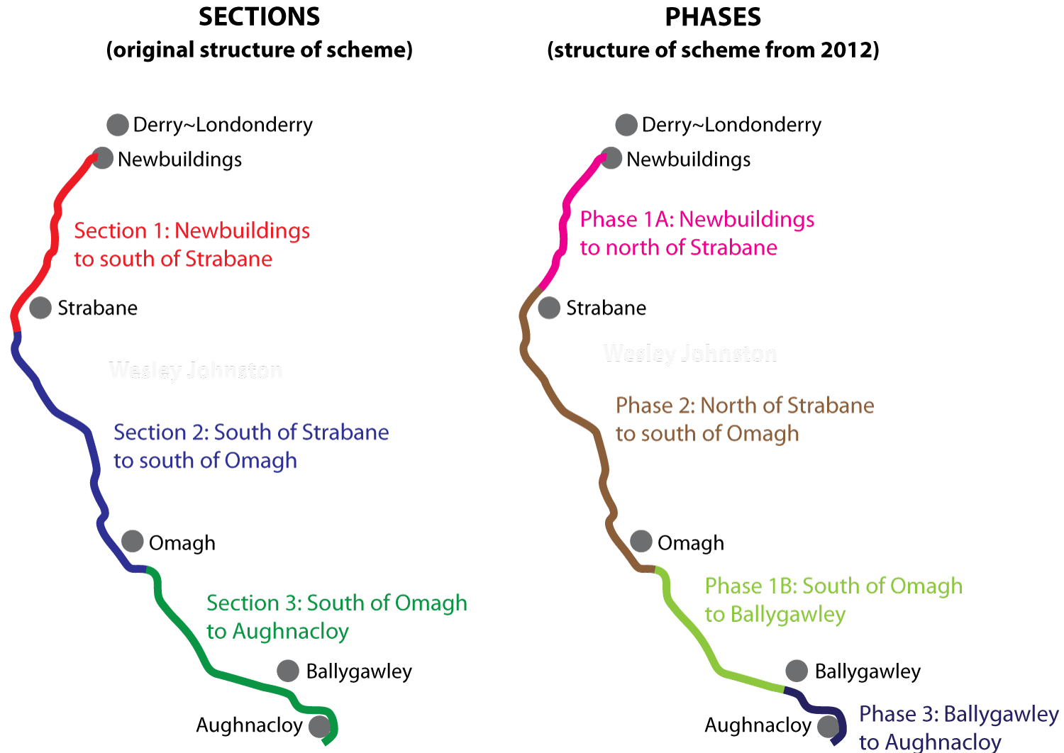
But firstly, I think it is necessary to
be clear on our terminology because DFI are
using so many terms now. When originally
designed, the whole scheme was divided into
three sections called (unsurprisingly) Section
1, Section 2 and Section 3. These are shown on
the first map below. However, in 2012 the
decision was made to build the road in phases,
rather than all at once. At that point the
scheme was rearranged into Phases – Phase 1A,
1B, 2 and 3 – representing the order they would
be built (though the contractors would still be
appointed by Section). The phases shown on the
second map below. So when talking about the
different parts of the scheme it's important to
note whether you're talking about a Section
or a Phase, because they are not the
same thing. Sections refer to the appointment of
contractors. Phases refer to the anticipated
construction order as it was in 2012.
 So with that out of the way, the next
thing to report is that the A5WTC web site has
published an update
on archaeological work that is now taking place
on the road (thank you to those who alerted me
to this). The document states that DFI is
working "within the current project delivery
programme ... and construction
commencing in early 2025. As such, there are
geotechnical and archaeological works that are
required in accordance with the programme."
If this is true, and the current works are being
done for this reason, then it is notable that
the works that seem to be "required" are all
between Strabane and Ballygawley, i.e. south of
Strabane and not including any of Phase 1A which
has for 12 years been top of the list for
construction. The document states that
archaeological/geotech work on Section 2 is
taking place from 2 April 2024 for about nine
months, and that archaeological/geotech work is
also to begin on part of Section 3, from south
of Omagh to Ballygawley, in mid July 2024 for
four months. No archaeological/geotech works are
planned for Section 1. To me this suggests that
if the scheme does go ahead in early 2025, then
it will have to be south of Strabane.
If the above change is actually on the cards,
then why? The only reason I can think of to make
a change like this is that the public inquiry
has raised an issue with Section 1 of the road,
something that makes the Minister unwilling to
approve it at this point. I don't know what this
issue would be, but we do now that some of the
most environmentally sensitive sections of the
scheme are on this stretch. It is also the
least-satisfactory stretch from a traffic
perspective, as it will end on the existing A5
at the north end of the village of Newbuildings.
So having listened to what is being said and
looked at these documents this is my current
theory:
- The Minister is going to approve Sections 2
and 3 only and delay a decision on
Section 1 for reasons that will presumably
become clear when the inspector's report and
DFI response are published in late
August/early September.
- With the limited money we know is available
right now, construction will begin in early
2025 on part of the road between
Strabane and Ballygawley, but not all
of Sections 2 and 3. From a road safety
perspective the stretch from Omagh to
Ballygawley makes far more sense, so I hope
that is the choice.
- That the terminology Phase 1A, 1B, 2 and 3
will be dropped due to being no longer
relevant.
5 Jul 2024: Shortly after my last
update, the DFI Minister said that he would be
formally making a decision (and that it would be
to proceed) on the scheme in August this year.
In the Assembly
on 1 July he confirmed this saying "I will
also be making a recommendation that we
proceed with the A5 upgrade" and (because
it's a major scheme and needs Executive
approval) "I will issue the papers to my
Executive colleagues, await their feedback and
then submit a further paper in mid-August for
their approval to move ahead with the A5
project." So that seems pretty clear that
the A5 will be approved for construction before
the end of August. With the contractor in place,
phase 1A and possibly 1B (the Minister recently
said NI would only be making a "small"
contribution to the A5 this year so 1B may not
begin with 1A) could in theory get underway
within weeks of that date. However, DFI seem
fairly certain that the Alternative A5 Alliance
will launch another legal challenge (they
haven't said they will, but haven't
ruled
it out) before construction gets underway.
They are entitled to do so, so it would need to
go through the legal system, and that will
probably delay work for a number of months until
it has been dealt with. DFI will have done all
they can to make their planning robust, so they
will be hoping they win such a legal challenge.
If so, work could get underway towards the end
of 2024 or early 2025. In case they do not, I
also suspect that DFI may be planning to
make some kind of change to the structure of the
project with the aim of breaking the planning
into sections that can hereafter be treated
separately, as opposed to one giant monolithic
project as it is now. This would mean that a
successful legal challenge would not necessarily
delay the entire project. This would require DFI
to find a mechanism to do this, so we'll have to
wait and see what, if anything, they come up
with. The second thing to update is that
the Infrastructure Committee at Stormont was
recently told by DFI officials that the cost of
the A5 project is now £1.7bn – the same figure
the Northern Ireland Audit Office gave in March.
Of this, £110m has
now
been spent. That sounds a lot (and it is)
but it is not an unusual proportion of money to
go on planning for a project worth £1.7bn: £110m
is just over 6% of the overall project cost,
which is on a par with other similar projects,
so I don't see it as concerning in and of
itself. The final thing to comment on is
that the Minister recently attended a meeting of
the North-South-Ministerial Council which he reported
to the Assembly on 2 July. In this he commented
that Dublin is currently planning two
dual-carriageway upgrades of the N2 (the
continuation of the A5) and that the two
jurisdictions are planning "phase 3 of the A5
from Ballygawley to the border, including the
proposal for a seamless cross-border link road
of approximately 3 kilometres in length, to
ensure successful outcomes through the
planning process." This is an
acknowledgement that the current plan is for the
A5 to curve round Aughnacloy but then turn off
this route to terminate at a roundabout on the
existing A5 before the border. This implies that
there will be a new plan for a cross-border
tie-in between the Aughnacloy bypass and the N2
in Monaghan.
19 Jun 2024: As we know, the PAC gave
their report from the public inquiry to DFI back
at the end of October 2023. Since then DFI has
been working on its response, a process which
has taken over 7 months so far. The Minister was
asked
in
the Assembly on 11 June about how they are
getting on with this job. He said "That
report included 30 advisory recommendations,
many of which are detailed and require legal
and professional review, advice and input.
That complex process is now close to
completion. I will be in a position to make an
announcement in respect of the scheme when I
have reviewed all of the relevant information
in relation to the project." So it sounds
as if we are not too far off an announcement of
what is going to happen next. I would expect
that the Minister will decide to proceed with
the scheme and announce this at the same time.
However, I am certain that DFI is doing a lot of
work to ensure that the documents they do
release are watertight as far as legal
challenges are concerned. We might not see an
announcement before the summer break, but I am
expecting it before the end of the calendar
year.
8 Mar 2024: A couple more updates on
this scheme. Firstly, the Northern Ireland Audit
Office published a report
at the end of February into major road schemes.
It summarised the position on the A5, but
usefully gave a new cost estimate of £1.7bn,
which is an increase of £0.1bn from a year ago.
It does show how the costs of the scheme keep
going up and up the longer it goes on. The DFI
Minister was asked
about the A5 in the Assembly two days ago, and
in particular whether he anticipates further a
legal challenge from opponents of the scheme. He
replied "Given the history of legal
challenges to the scheme, I expect that there
will be more, unfortunately." He went on
to confirm that he is still considering the
report of the public inquiry. Once he has
completed that he will publish DFI's decision,
along with the report itself and DFI's response.
Assuming a positive decision, the scheme would
then move towards construction. A legal
challenge, if one were made, would likely be
timed to come shortly before work began, i.e. in
late 2024. Interestingly, the DFI Minister said
that he was going to make the case to the UK
government to provide funding for the scheme. He
said "I am also engaging and plan to engage
with the UK Government. The A5 is mentioned in
the UK connectivity report, and the British
Government and the Treasury therefore have a
responsibility to contribute to that major
piece of infrastructure". Personally I see
that avenue as having a low probability of
success, but it is certainly worth making the
case. The same session of the Assembly also saw
an Adjournment Debate on the project, which can
be read here.
Such debates don't carry any weight but give an
opportunity for MLAs to express their views on a
subject.
21 Feb 2024: Yesterday the Irish
government announced
that they are revising their funding for the
scheme upwards from £75m to €600m (£514m). This
represents a significant increase in funding and
will allow Phase 1A (Newbuildings to North of
Strabane) and possibly Phase 1B (South of Omagh
to Ballygawley) to get underway by the end of
this year, assuming the scheme has passed the
public inquiry, and assuming no more legal
challenges. Welcoming
the
news, the DFI Minister explicitly appealed
to opponents not to launch any more challenges.
The whole scheme now costs at least £1.6bn, and
possibly a bit more as this figure dates from
late 2022. There has been a huge level of
construction inflation over the past five years,
particularly with Covid and the war in Ukraine.
The cost of Phase 1A was given as £207m in 2019,
but this likely to be closer to £300m today.
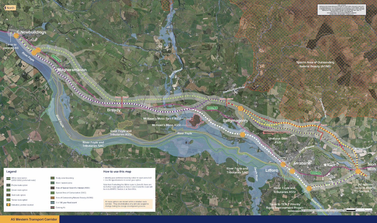
Similarly, Phase 1B was costed at £270m in 2019,
but this is now likely to be closer to £380m. So
this is a total cost of £680m for these two
phases. With £514m from Dublin I do think it is
realistic that Stormont will be able to come up
with the remaining £166m, especially given that
the money doesn't have to be spent all at once,
but can be phased over 3-4 years.
What is less certain is the future of Phases 2
and 3. Phase 2 includes the main bypasses of
Strabane and Omagh, plus the stretch in between,
and is the most expensive element of the whole
project, with a cost likely to be in excess of
£700m in today's prices. There is little
prospect of Phase 2 proceeding in the
foreseeable future as it is unlikely that
Stormont will be able to raise this level of
funding in the foreseeable future with the
competing pressures in health and education that
it faces. That said, Dublin has indicated that
today's tranche of money is only the start of a
longer term allocation of cross-border funding
that could eventually reach €3.5bn, so there is
a possibility that further stretches of the
project will get support in a few years' time.
Phase 3, which is the cheapest at about £200m in
today's prices, connects Ballygawley to the
Monaghan border at Aughnacloy. The public
inquiry inspector previously recommended that
this section NOT be built in the absence of a
plan to upgrade its continuation, the N2, in
Monaghan. This may be why the Irish government
also announced today funding to advance planning
for the upgrade the N2 from Clontibret to the
Tyrone border at Aughnacloy, a lengthy scheme
that will see 28 km of road upgraded to
dual-carriageway standard.
Almost 50 people have been killed on the A5
since the scheme was announced in 2007, so
yesterday's events will be bittersweet for the
bereaved. Phase 1B is the section with the worst
safety record, so this is a particularly welcome
section to be done.
So what happens next? The next thing
will be the publication of the pubic inquiry
inspector's report plus DFI's response, which I
would expect in the next few of months. I am
expecting the report to make quite a few
recommendations on the design and possibly the
phasing, but not to recommend against building
the road itself. Since contractors have already
been appointed, construction on Phase 1A and
possibly 1B would then move towards commencement
of construction in late 2024, with completion
probably by early 2027. It will be a very
interesting time for travelers in the West.
9 Feb 2024: With Stormont back up and
running this week after two years, a lot of
attention has returned to this scheme with Sinn
Féin in particular explicitly naming it as a
priority. One of the first things the new DFI
Minister John O'Dowd will have to do is consider
the report by the public inquiry inspector which
DFI have had since Hallowe'en. It is likely that
DFI civil servants have already completed much
of their work in responding to the report, so it
will be up to the Minister to make a decision
about whether to proceed and, if so, how to
respond to the Inspector's recommendations. In
terms of funding, it has been obvious for some
time that the scheme is now unaffordable for the
Executive. However, for the past year there have
been hints that Dublin is going to step in and
fund at least some of the shortfall. Dublin
likely did not want to make any move on this
without an Assembly and perhaps still does not
want to do so ahead of the publication of the
Minister's decision on the public inquiry, so as
not to be accused of ignoring due process.
However, there are strong hints now that this is
what is going to happen. According to the Derry
Journal Paschal Donohoe (the Irish
Minister for Public Expenditure, National
Development Plan Delivery and Reform) was asked
about the A5 scheme. He replied that "The
Government continues to remain committed to
the development of the A5 project... the
Government will shortly be considering
proposals we can make that will support the
really positive news regarding the
reconstitution of the Good Friday
institutions... We will look at how we can
continue to support the development of an
all-island economy to the particular benefit
of the communities the Deputy just referenced.
I expect there will be further progress on
that soon."
13 Dec 2023: A brief update to say that
in the most recent report
to Fermanagh and Omagh District Council, DFI
confirmed that the report of the public inquiry
was received on 31 October, and that "Preliminary
options
on next steps anticipated to be presented to
the Permanent Secretary in the coming weeks".
A decision to proceed would then need to be
taken, and at this point it's not clear if this
will be a Minister from a restored Executive, or
a senior civil servant. Such a decision could be
expected by early spring. It is still possible
that, in the event of Stormont being restored,
Dublin may offer increased investment for the
A5. Time will tell.
15 Nov 2023: DFI have confirmed that the
inspector of the public inquiry – that was
completed in June – has now handed his report to
the DFI. This report will contain general
recommendations about the scheme (e.g. in terms
of phasing) and also quite a few specific
recommendations (e.g. in terms of issues raised
by individual landowners). The report is NOT
released publicly at this point. Instead DFI
will take time to consider the recommendations
and write a document detailing how they are
responding to each of them. This is known as the
Departmental Statement. Both the inspector's
report and the Departmental Statement will be
published at the same time. When this happens
depends on the nature of the recommendations,
but also on how much of a hurry DFI are in. With
the first public inquiry eleven years ago, they
took four months to go through this process.
However, on the A6 Dungiven-Drumahoe scheme they
took three years. As DFI regard the A5 as a
flagship project I think it will be somewhere in
the 3-4 month ballpark, so I'd expect to see
them published by the early spring. Assuming the
scheme passes the inquiry (which it likely will)
construction could get underway on phase 1A
(Strabane to Newbuildings) later in 2024. There
is always the prospect of another legal
challenge. However, this time, DFI, will likely
have got their own solicitors to ensure that the
scheme is watertight for legal challenges. So,
while a legal challenge might cause a bit of a
delay, I don't think it is likely to halt the
plan this time. I also think it's likely that
the Dublin government will make some move
towards increasing funding for the A5 once it
has completed the legal processes.
19 Jul 2023: A couple of months ago I
commented, as I have done several times in
recent years, "the [A5] scheme is now
unaffordable for Northern Ireland, major
external funding is the only way it will
happen". Since the cost of the scheme is
now £1.6bn, and Northern Ireland so far has only
been able to allocate less than a quarter of
that sum, and given the perilous state of
Northern Ireland finances, the scheme cannot
happen any other way. However, the past couple
of months has seen increasing overtures from the
Dublin government that they are prepared to step
in to make the project happen. This would be a
lifeline for a project that will otherwise not
be completed. The Dublin government is being
very careful not to be seen to be presupposing
the outcome of the public inquiry and other
statutory process, and has therefore made no
formal commitments. However, last week, in an
address to business leaders from Northern
Ireland the Tánaiste Micheál Martin said "...we
want
the A5 completed and we will not be found
wanting". He would not be drawn on a
figure, saying that "When we get the outcome
of any tender process, then we will work out
the Irish Government’s commitment". The
tender process is already complete, in that the
contractors have already been appointed, though
the final figure is fluid. So the Tánaiste
likely simply meant that he would wait to get a
more up-to-date cost estimate before deciding
what Dublin would contribute. However, any
figure less than £1bn would be unlikely to be
enough to allow the scheme to proceed. Either
way, the possibility of actually completing this
project is looking better now than it has for a
good few years. We await the outcome of the
Public Inquiry which will probably be made
public in early 2024.
21 Jun 2023: The Public Inquiry sat
again in the last week of May and concluded on 2
June, after hearing two weeks of evidence.
Normal procedure at this point is for the
inspector to take a number of months to consider
the evidence and will then produce a final
report which will be given to DFI. This
typically features a large number of
recommendations relating to very specific
localities, and sometimes recommendations on the
scheme as a whole. I would expect this to be
done by the end of 2023. However, it is not
released publicly at this point, as DFI will
then take a period of a few weeks/months to
consider the recommendations. They will then
publish both the inspector's report and their
response simultaneously, which I'd expect
perhaps by spring 2024. The Enough is Enough
campaigners (who support the proposed upgrade)
issued a press
release where they thanked those who had
given evidence, mostly on the basis of road
safety and lives lost, and confirmed that the
inspector had said that he would submit his
report to DFI before the end of 2023. The Alternative
A5
Alliance, who oppose the upgrade as
proposed, made their case at the inquiry too.
Their solicitor was quoted here
as saying that "The Alternative A5 Alliance’s
position has been that this is overprovision,
representing a disproportionate impact on the
livelihood of landowners, with significant,
long-lasting and irreversible environmental
harm". They acknowledged that road safety
was a major issue, but added that "this
factor must be weighed up along with other
important material considerations. The first
week of the inquiry showed that many
individuals from different perspectives have
very serious and deeply held concerns about
the environmental aspects of this scheme and
these must be given appropriate weight in any
decision.” The inspector has a difficult
job as he weighs up factors that are materially
different, very emotive, and difficult to
compare to each other in a strucured way. The BBC
published an article on 31 May saying that, at
the inquiry, a senior DFI official had said he
was "very confident" the new road would be
completed by 2028. This strikes me as unlikely.
Firstly, we don't have enough money allocated to
build even a third of the road at this point, so
the only way that this could happen would be a
major (not far off £1bn) cash injection,
probably from Dublin (which is certainly
possible but not confirmed). Secondly, such a
timescale would require work to have started on
every part of the scheme by the end of 2025,
which is also possible, but ambitious given that
we're still at the public inquiry stage and that
there may well be further legal challenges. So
at this point you could call me "unconvinced" by
the 2028 date, but certainly willing to be
proved wrong.
17 May 2023: The public inquiry
re-convened as planned this week. This first
week has focused primarily on environmental
issues such as wildlife, communities and built
heritage. This time, supporters of the scheme
meeting under the banner Enough
is Enough have attended the inquiry each
day and worked to generate publicity.
Due to the unexpectedly large number of members
of the public attending this week, which is
expected to be repeated the next week, the
Inspector has announced that next weeks' session
will be in the Strule Arts Centre, not Omagh
Enterprise Centre as previously planned. The
next week will look at the wider strategic
isssues, including the justification for the
scheme and alternative options. In other news,
Dublin has hinted
that it is open to the idea of increasing their
contribution to the A5 (currently £75m towards a
£1.6bn project), but it is likely withholding
any further movement on the issue until the
scheme has navigated the current planning
process, and perhaps also for a more
politically-expedient moment. The Irish Finance
Minister said "There is a willingness on the
part of the Irish Government to re-examine
this issue and see what more we can do to
bring about fruition of this project". He
added "But we do need partners that we can
sit down and negotiate with and have a
discussion with in the form of the British
Government and the Northern Ireland executive".
This
suggests they may be seeking some kind of
contribution from the UK government in addition
to the Executive. Given that the scheme is now
unaffordable for Northern Ireland, major
external funding is the only way it will happen,
even if it passes the public inquiry. Note that
there IS funding for at least the first section
(Newbuildings to North of Strabane), so if it
passes the puhblic inquiry work could still get
underway on that stretch in 2024.
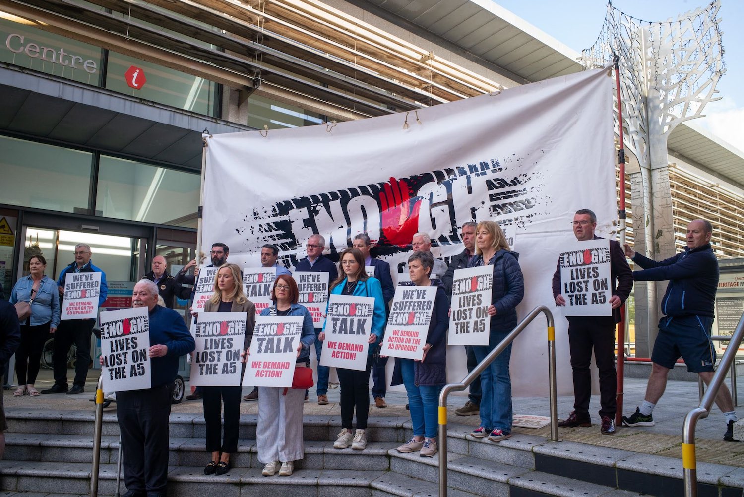 Members of the Enough is Enough
group who support the proposed scheme to dual
the A5 [Enough is Enough] 17 May 2023.
10 May 2023: The public inquiry
(adjourned since 2020) is due to reconvene in
five days' time. Ahead of this the new pressure
group, Enough
is
Enough held a public
meeting in Omagh yesterday to push for the
scheme to go ahead. Speakers at the event asked
the objectors to reconsider their opposition to
the road. Minds have been focused in the past
few weeks by the tragic
collision that occurred near Aughnacloy on
27 April with the loss of three lives. The
delays to the scheme have been primarily caused
partly by legal challenges (some of which were
successful) in recent years, but even without
these delays Northern Ireland simply does not
have the £1.6bn needed to build the road. The
upshot is that, even if it is approved for
construction, it is no longer possible to build
the whole road in a realistic timeframe. When
the scheme was first announced in 2007 the
Dublin government offered to pay £400m (just
under 50% of the cost as it was then). This has
since been reduced to a total of £200m (which is
about 13% of the cost as it is now). With Dublin
reporting a massive budget surplus this year,
minds have understandably turned to whether
Dublin might
consider
increasing their contribution again. If
that does not happen – and it's entirely a
matter for Dublin – then the next best option is
to scale the project back to focus on the most
dangerous stretches and the bypasses of Omagh
and Strabane. But this is also one for the
politicians, and currently we have no Executive.
22 Mar 2023: The Planning Appeals
Commission announced
last week that the public inquiry that was
adjourned in 2020 will be re-convened on 15 May
2023, a little later than I'd predicted. The
inquiry will take place in two stages as
follows:
- 15–19 May 2023 in Strule Arts Centre, Omagh.
This week will focus on the scheme on its own
terms, examining the environmental statement,
the habitats reports and the proposed
supplementary vesting order.
- 30 May – 2 June 2023 in Omagh Enterprise
Centre. This week will focus on the wider
strategic issues, such as the justification
for the scheme, alternatives, funding and
phasing.
Normally public inquiries only focus on the
first of these elements. This inquiry is unusual
as it is being carried out by the Planning
Appeals Commission and it was they who decided
back in 2020 that they would permit discussion
and examination of the strategic issues around
the scheme as well. I would encourage all those
with an interest in the scheme to aim to attend
the inquiry and express their views. DFI had
been hoping that Phase 1 (Newbuildings to north
of Strabane) could get underways in late 2023
subject to a successful public inquiry outcome.
However I no longer think this is realistic as
the PAC will need time to consider the
submissions and prepare a report. Sometime in
2024 seems more likely. My own views on the
future of this project are already on record -
see update for 9 November 2022 below.
25 Jan 2023: DFI has now announced a
further public consultation into revised
documents on the A5. They are available here.
The reason for the new consultation is that
these documents contain drawings of the entire
scheme plus additional "cross section" diagrams
of the proposed route that had been requested by
the Planning Appeals Commission. This
consultation is open until 3 March 2023. This
latest consultation is typical of this scheme
which is a seemingly-endless cycle of public
consultations, legal challenges and other delays
that seems to go round over and over again. As
it is now 16 years since planning for the scheme
began, immense frustration is evident, most
recently by the formation of a new pressure
group, Enough
is
Enough that has been
set
up to push for an end to these delays.
They note that 44 people have died on the A5
since the scheme was announced in 2007. They
held a very well-attended public meeting in
Tyrone GAA centre on Monday 23 January. The
public inquiry was due to begin today, but the
new consultation has delayed that. DFI said that
"It is hoped that the reconvened public
inquiry be swiftly reconvened thereafter [when
the consultation closes], the timing being at
the discretion of the PAC”. So I would
think sometime in late March or early April
seems likely. Even if the scheme passes the
inquiry it's not clear if DFI can proceed in the
absence of a Minister. My own views on the
future of this project are already on record -
see update for 9 November 2022 below - but in
summary I no longer think that this scheme can
happen as envisaged, due to the mushrooming
cost, and that rethinking the basis of the
project is key to doing something that has a
better chance of saving lives going forward on
this dangerous and congested road.
25 Nov 2022: The Planning Appeals
Commission had planned to reconvene the
adjourned public inquiry into the scheme on 25
January 2023. They held a preliminary meeting on
15 November at which it became clear that the
Department for Infrastructure would not be ready
by then due to the most recent public
consultation on yet another set of modified
documents. The PAC has therefore to issue a
revised timetable, as reported in the Tyrone
Constitution, with some suggestions that it
could be delayed to March. With thanks to those
who got in touch with me about this. DFI
continue to talk about this scheme as if it will
all happen. In my previous update below I set
out why it cannot happen in the form envisaged
and my views on what should be done next.
9 Nov 2022: DFI recently
announced another public consultation on
the scheme, this time because of some minor
adjustments to various scheme documents. The
closing date is 23 December. The word on the
street is that the public inquiry that was
adjourned two and a half years ago in 2020 will
be re-convened in January 2023, though this has
not been officially confirmed. The scheme
documents that have been released include a new
total cost estimate for the scheme, which is now
given as £1.609 billion. That is an
increase on the £1.134 billion in 2019 and the
£844m as of 2009 when the Irish government
committed to funding £400m of the cost. The
Irish government contribution has been partly
paid (£200m £75 up to 2022) but
has not increased. This means that the amount
that Northern Ireland needs to spend has
increased from £444m to £1209m, a tripling of
the cost. I feel I have to pause at this point
and point out that this scheme is now so
divorced from reality as to be living in a
parallel universe. The DFI documents still
envisage the entire scheme being completed by
2028. To achieve this we would need to spend not
far off £200m per year on this
single scheme for the next six years. That
contrasts to DFI's entire expenditure on
all roads in the whole of Northern Ireland (not
just new roads, but the maintenance of 25,000 km
of our existing roads) of £227m in the last
financial year. It also contrasts with the cost
of the current A6 Derry to Dungiven upgrade
which has a total cost of £220m over the space
of four years. And we would be expected
to come up with this money annually at a time
when there is no Executive, a Health Service in
crisis and a looming recession. It is obvious to
me, just as it must be obvious to DFI and should
be obvious to elected representatives, that this
scheme is now completely unaffordable.
That's not to say anything about the merit of
the scheme, of course. As I recently
pointed
out 1 out of every 6 fatalities in
Northern Ireland in the past year has been on
the A5, which is one every 5 weeks on average.
People are regularly dying on this road. Since
January 2012, 29
lives
have been lost and the worst stretch is
Omagh to Ballygawley with 13 deaths. We have to
stop this madness – what we are actually doing
by focusing on a theoretically excellent but
undeliverable scheme is eliminating the chances
of any improvements happening. So what
should we do? Just as in Alcoholics Anonymous,
the first step is to recognise that there is a
problem. I suggest the following:
- Now: Public representatives must
accept that the A5 scheme will not happen
in the form proposed because it can't
happen. No amount of willpower is going to
come up with the cash that would be needed.
- Short term (aim to be completed in
less than 5 years): Carry out a road safety
audit on the Omagh to Ballygawley stretch with
the aim of targeted interventions. For
example, a series of roundabout upgrades at
the worst junctions with differential
acceleration lanes leaving them to allow
overtaking of slow vehicles. And possibly the
lighting of the busier T-junctions, improved
sight-lines on corners and the selected
imposition of a 50mph speed limit on some
stretches. Similar interventions could be
targeted on other sections of the A5 too. This
would bring the quickest improvement to road
safety.
- Medium-term (aim to be underway or
completed within 5-10 years): Bring forward
plans for dual-carriageway bypasses of
Strabane and Omagh, and build them as
stand-alone projects. This would involve going
back to an earlier design stage, but surely
nothing could take longer than the current
endless cycle of inquiries. This would bring
the quickest improvement to journey times,
as these are the two worst bottlenecks.
- Long term: Once the bypasses are
built, focus next on dualling the Omagh to
Ballygawley stretch. This would further
improve safety and also complete a
dual-carriageway/motorway link from Omagh to
Belfast.
6 Oct 2022: DFI gave an update on this
scheme in their annual
report to Mid Ulster District Council last
week. It was mostly repeating information we
already knew, but it did add that "discussions
are
on-going with the PAC on the timing of the
reconvened public inquiry. It is hoped that
the inquiry can be reconvened later this
calendar year". PAC is the Planning
Appeals Commission who ran the public inquiry in
2020 which was adjourned to allow DFI to carry
out more development work. DFI have now
completed this work and a new public
consultation has ended, so it looks like DFI
hope that the inquiry can be reconvened by the
end of 2022. This would mean the PAC giving its
final report in mid to late 2023 which then, in
theory, allow the Minister to make a decision to
proceed. This could probably happen even without
an Executive as it's been designated a Flagship
project and is already committed.
24 Aug 2022: According to a recent question
for
Written Answer, DFI are hoping that the
Public Inquiry into this scheme, which was
adjourned two-and-a-half years ago in Feb 2020,
can be resumed in "the autumn of this year". The
Planning Appeals Commission inspector adjourned
the inquiry at that time and instructed DFI to
go and do more work around the planning and
rationale for the scheme. This work is complete
and a public consultation on the resulting
Addendum to the Environmental Statement ended in
May 2022 with over 200 responses received from
the public. Assuming the PAC approve the scheme
following the public inquiry, DFI are then
hoping to approve the scheme for construction
"during 2023".
It is worth noting that DFI don't have enough
money to build the A5 as proposed. My own view
on this is that the deteriorating financial
situation and years of delays means that this
scheme is now unaffordable and will
therefore not happen in the form proposed. My
firm view is that politicians must
accept this and salvage what they can by
reducing the scope of the project to the
bypasses of Strabane and Omagh only and defer a
decision on the bits in between for a better
future financial climate.
23 Mar 2022: Exactly a year after DFI
published the interim report of the Inspector at
the Public Inquiry held in spring 2020, DFI have
published (on 16 March) an updated Environmental
Statement and numerous related documents. These
can be accessed here.
There is a huge amount of documentation here,
running to thousands of pages, but what I
consider the three main takeaways are as
follows. My own comments on these follow after.
- DFI are still working to a schedule of work
on phase 1A commencing in late 2023 and the
entire project (phases 1A, 1B, 2A, 2B and 3)
all being completed within 5 years, ie by the
end of 2028, assuming the availability of
funding.
- As requested by the Public Inquiry
inspector, DFI considered alternative phasing
of the project. In particular, they looked at
the impact of building the two main town
bypasses first, followed by the sections in
between. They concluded that they did not
support altering the phasing because the
alternative would be more costly in terms of
additional temporary tie-ins, the reduced
opportunities for cut/fill balance along the
scheme if it's built in a different order,
increased land-take for temporary tie-ins,
increased hauling distances, and increased
short-term traffic impacts due to platooning
of vehicles on the sections not yet upgraded.
- As requested by the Public Inquiry
inspector, DFI have considered alternatives to
the scheme, namely the reduced option of
bypasses of Omagh and Strabane, plus 2+1
overtaking opportunities on the rest of the
road. The conclusion was that this proposal
was feasible, and would bring benefits but
that these benefits would not be as great as
the proposed scheme and it would not fulfill
the scheme objectives. In addition, they
concluded that the town bypasses would not be
completed until 2032 following 4 years of
statutory processes and 4 years of
design/construction. The 2+1 overtaking
opportunities would not be provided until 2034
following commencement of detailed design in
2030. It would result in approx 33 accidents
per year along the A5, as opposed to 16 with
the proposed scheme. The report doesn't seem
to discuss deaths/serious injuries in relation
to the alternatives.
It is understandable, and expected, that DFI
would take the position that the current scheme
is still the best, given that the Executive has
explicitly instructed them to build a
dual-carriageway and they must work within that
limitation. It is also understandable that they
have defended the current phasing for the same
reason. Nevertheless, I have issues with what
has been published.
- On point (1) above, the idea that the whole
project from Newbuildings to Aughnacloy could
be completed by 2028 is completely
implausible. Not from an engineering point of
view, but from the point of view of funding.
The entire scheme now costs about £1.2bn, of
which around £100m has been spent already.
This leaves £1.1bn to find over the course of
five years. The Irish government has already
paid or committed £200m of the £400m they
originally proposed, leaving Stormont to find
at least £700m (and potentially up to £900m).
It is implausible to me that, following two
years of Covid and in the middle of an energy,
health and supply chain crisis, that Stormont
will be able to stump up £700m of cash on such
a short timescale when there are such
significant competing interests in areas such
as health.
- This leads to point (2) above, the phasing.
The phasing report is contingent on the
funding being allocated within the five year
timeframe, despite this seeming unlikely to be
the case. To my mind the reasons given for the
increased costs with alternative phasing are
minor (eg increased haulage distances) or even
facetious (platooning of vehicles, which is
unlikely to be worse than that on the current,
heavily-congested A5). Given that the project
is likely to take longer than the five years
anticipated, temporary tie-ins are an
inevitability, so the fact that they're needed
for the alternative does not seem like a major
point against it. I don't find the arguments
in this document to mount to a convincing case
for the current phasing.
- Finally, on point (3) above, the
"alternatives" study essentially states the
obvious, namely that a scheme reduced in scale
and cost would bring correspondingly fewer
benefits. The real point, however, is that the
most recent benefit/cost figures revealed at
the public inquiry in 2020 indicate that only
the town bypasses now make economic sense. For
much of the A5, the scheme will cost more than
the economic benefits it will bring to the
West. So therefore there is a compelling
economic reason to consider the alternative.
The very long timescale given (completion by
2034) seems to assume that the design and
statutory processes would begin again from
scratch. This might well be necessary in
certain circumstances, but we do have
completed designs for bypasses of both towns
as part of the bigger scheme. A "middle
ground" approach would be to build the
bypasses first, to the design and form
proposed, with the assumption that if the
remainder of the scheme eventually fails to
materialise, at least the most congested
sections (and the only sections that make
financial sense) would be done. This would not
take until 2034. I think this document misses
the point to some degree.
It is my view, and has been for some time, that
the cost of the scheme has now risen to the point
of being unaffordable and that the best the
Executive can hope for is to scale it down to the
two town bypasses only, the sections that would
have maximum impact on journey times, and then
look further at the remaining sections of the A5.
The sooner the Executive accepts this reality and
frees the civil servants in DFI from the shackles
of the 2007 scheme, the better the chances of
making actual material benefits to the A5.
22 Mar 2021: On 16 March DFI
published the interim report of the Inspector at
the Public Inquiry held in spring 2020. The
report is available here,
along with DFI's response. The inspector's
report was considerably more critical of the
scheme than I had anticipated. I have said a
great deal (!) about this development over on
my
blog, but for this update the basis
recommendations are:
- That the overall rationale of the project in
terms of road safety and impact on vehicle
drivers is excellent.
- That the impact of the scheme on the
environment, and in particular on climate
change, is very negative.
- That DFI hasn't shown beyond doubt that a
series of sensitive areas along the route
won't be adversely affected, and has requested
DFI carry out further environmental
assessments. The inspector has not
said that the scheme will adversely
affect these areas, just that DFI haven't
demonstrated this adequately.
- That DFI haven't taken into account the most
recent flooding data. The inspector has asked
DFI to re-examine flood risk on the basis of
the most up-to-date flood data.
- That alternatives proposed by others, namely
an online dual-carriageway or construction of
a railway line, are unlikely to achieve the
benefits required and are hence not to be
recommended.
- That DFI should examine a scaled-back option
of a bypass of Omagh and a bypass of Strabane
with sections of 2+1 overtaking opportunities
on the rest of the A5. The Inspector has not
said that this would be a better option, but
has said that it needs to be detailed in order
to establish a baseline against which the
proposed scheme can be compared.
- Given the issue of blight of farmland and
property, that DFI should not decide to
proceed with any part of the scheme until
money has been allocated and ring-fenced.
- That Phase 3 (Ballygawley to Aughnacloy)
represents poor value for money and should be
abandoned.
- That he does not see the logic in the
phasing of the different parts of the scheme,
and that this should be reconsidered.
DFI have accepted all but the last two
recommendations, and are sticking by both the
plan to build the planned road in its entirety,
and to build it in the order proposed. This is
presumably because these two decisions were made
by politicians, under whose authority DFI must
operate. The DFI Minister, for her part, issued
a press
release where she said that she remains
"committed" to the A5. She said "I know this
project has been long awaited and I am
determined as Minister to see it progress
through the statutory process as quickly as
possible, ensuring the project is delivered
properly for citizens and our wider
environment."
She will struggle to proceed quickly on this,
because the new documents that have to be
produced will take until the autumn, at which
point they will be put out for public
consultation, probably taking until Christmas
2021. The Public Inquiry, which is currently
adjourned, will then need to resume in early
2022, after which the inspector will issue a
report by mid 2022, which DFI will probably
publish and respond to in late 2022. So even if
the scheme survives this process, commencement
of construction is now about two years away (16
years after project commencement). Given this
timescale, plus the lack of funding for anything
beyond phase 1, the plan to have the whole thing
completed by 2028 now seems highly implausible.
As I outline in my blog, I do feel that this
project is now in difficulties and we are at the
point where the Executive has to make some hard
choices.
29 Oct 2020: Two weeks ago the Irish
government announced
the creation of a Shared Island Fund, which will
have funds of €500m over the next five years to
invest in all-Ireland projects. The fund will be
used for various purposes, but cross-border
infrastructure projects seem to be high on the
agenda, especially roads, rail and greenways.
They explicitly mentioned the A5
dual-carriageway as one of the schemes that they
would be interested in funding. The Irish
government has already spent or committed £200m
towards the A5 in the period up to 2022. It's
not clear whether this is a re-announcement of
the committed funding or whether the project
could benefit from investment over and above
this. At a total cost of over £1.1bn Stormont
cannot afford to build the whole road itself, so
only sections of it will proceed without further
investment. The move was welcomed
by the Northern Ireland Infrastructure Minister
who again highlighted the A5.
25 Sep 2020: DFI have said that on 2
September an Interim Report from the Public
Inquiry that was carried out by the Planning
Appeals Commission (PAC) in March was submitted
to DFI. "Interim" reports are unusual for road
schemes, so I am curious as to why it is
necessary. It has not been made public. It will
likely contain a series of recommendations -
principally, whether the scheme should go ahead,
but also a series of more minor recommendations
about specific issues and locations along the
route. DFI will now take a period of time,
typically a few months, to examine all these
recommendations. They will then prepare their
response as a Departmental Statement. It will be
up to the DFI Minister to decide when to publish
this and the Interim Report. So far this
timescale is in keeping the Minister's hope to
begin work on the first phase in mid 2021.
12 Jun 2020: A brief update to say that
the DFI Minister announced her department's budget
two days ago. She confirmed that she has
allocated money to continue work on the A5
scheme. She was asked in the media about the
dates for the construction of Phase 1A
(Newbuildings to South of Strabane) and she
stated that it could begin in "mid" 2021,
subject to passing the public inquiry and
barring delays caused by another legal
challenge. This is a slight slippage in
expectation, but still only a year away. As of
today, we are all waiting for the inquiry
inspector to submit his report on the March
public inquiry, currently anticipated at the end
of September 2020.
10 Apr 2020: The latest public inquiry
into the A5 scheme took place in March, starting
on 11 March at the Strule Arts Centre. Unlike
most public inquiries for roads, this one was
carried out by the Planning Appeals Commission
(PAC), the purpose being to ensure it was
totally independent of DFI Roads. There was also
a pre-inquiry meeting in February which was held
to determine the structure of the inquiry. The
new inquiry was necessary because of the delay
caused by the most recent (2018) legal
challenge, which DFI Roads conceded on a
procedural point, which caused the environmental
documents to go out of date. Since the next
(practically inevitable) legal challenge will
itself cause another delay, there sometimes
seems to be no route out of this endless cycle.
Although it was intended to just be an
examination of the updated Environmental
Statement, the PAC seem to have allowed the
whole rationale for the scheme, including
alternatives to the dual-carriageway, to be
re-examined at the March Public Inquiry.
According to the DFI Minister in
March, the inquiry Inspector is now
expecting to submit his report to DFI at the end
of September 2020. DFI will take time to
consider the recommendations of the inquiry and
then issue their response a few months later,
perhaps at the start of 2021. Assuming the
inspector recommends the scheme proceed, this
could allow construction to begin on Phase 1A in
"Spring 2021". There will, presumably, be
another legal challenge at that point so this
probably won't happen in practice. DFI will be
hoping that if there is another legal challenge
then it will be dismissed quickly. Over the past
couple months three of things have happened that
do make the future of the scheme look a little
shakier. Firstly, there was a landmark ruling in the
UK's Court of Appeal in late February, where
campaigners won a legal challenge to Heathrow
Airport's proposed third runway. The grounds
were that the plan did not take into account the
Paris climate agreement, which seeks to limit
global warming. The Paris agreement applies to
Northern Ireland, so this would obviously make
every large infrastructure scheme susceptible to
legal challenge on the same grounds. Secondly,
the global COVID-19 pandemic, and likely global
depression, could result in the Irish government
being forced to withdraw their funding for the
A5 scheme, as they did nine years ago in the
last recession. Thirdly, there have been
suggestions from some
quarters that the experience of the UK's
current lockdown could result in a permanent
shift by many workers to home-working,
suppressing traffic levels for years to come.
Even a drop of 25% would make a massive
difference to traffic congestion. It is too
early to say if this will happen, but if it does
it might require the re-assessment of the
rationale for each individual road scheme. All
of these events could conceivably conspire to
prevent the scheme going ahead at all. For now
all we can do is await the outcome of the Public
Inquiry in six months' time, and then wait to
see the grounds of the next legal challenge.
27 Jan 2020: With Stormont finally
being restored earlier this month, the New
Decade New Deal makes explicit mention of this
scheme. The British government's section merely
lists the A5 as an example of the type of
project that the new Executive could choose to
fund, without committing anything to it. However
the Irish government has committed in concrete
terms to giving a total of £75m towards the
scheme over the next three years. This mirrors
the £125m that they have already paid over the
past three years, bringing their total
contribution up to £200m. Given that about £80m
has been spent on the project so far, this means
that the Irish government has essentially
bankrolled the scheme up to this point. A new
public inquiry, limited in scope to some updated
environmental documents, is due to get underway
on 18 February. In one of her first Written
Answers, the new DFI Minister Nichola
Mallon mirrored the DFI's stated position,
saying "I am hopeful that first phase of this
scheme, from New Buildings to north of
Strabane (Phase 1A) could commence in late
2020 / early 2021 with completion in 2023."
A
new legal challenge by the Alternative A5
Alliance will, of course, have to be dealt with
by the courts but DFI will be hopeful that their
rigorous work over the past few years will
protect the scheme from any further successful
challenges.
7 Jan 2020: The Northern Ireland Audit
Office published
a report into major infrastructure projects on
18 December 2019 and - unsurprisingly - the A5
scheme featured! The report noted that the
scheme stands to be about ten years late and
with a cost over-run of £301m. More
interestingly from the perspective of this web
site, the report gives the first "official"
overall cost figure that I have seen in several
years. It gives the cost of the
Newbuildings-Strabane stretch as £207m, Strabane
to Omagh as £499m, Omagh to Ballygawley as £270m
and Ballygawley to as £158m. That gives a total
of £1.134bn. This is in keeping with my comment
in 2016 (below) that the scheme was likely to
cost in excess of £1bn. These represent
substantial cost increases, even taking
inflation into account. To date about £80m has
been spent and no construction carried out. DFI
do, however, estimate that work will begin later
in 2020 on the Newbuildings to Strabane stretch,
even though there will probably be another legal
challenge following their decision to approve
construction. DFI will be hoping that the courts
will dismiss such a challenge, allowing work to
get underway at long last. The NI Audit Office
report noted that the legal challenges tend to
self-perpetuate, since DFI are required to keep
their information both comprehensive and
current. This, they said, "perpetuates the
development cycle when interspersed with
delays through legal challenge. The legal
challenges mounted (on multiple grounds)
result in delays, with consequential impacts,
for example, on environmental and design work.
This necessitates further work, time and
funding to rebut each challenge and to update
and refresh assessment/design work
sufficiently to be robust and defensible."
The implication is that legal challenges on even
minor grounds can result in years of delays and
millions of wasted pounds. This situation may be
something for Stormont legislators to consider
in the years to come.
9 Nov 2019: DFI have now announced the
dates for the public inquiry that will be held
into the updated Environmental Statement. It
will open at 10.30am on Tuesday, 18th February
2020 in the Strule Arts Centre, Townhall Square,
Omagh and will last as long as necessary. You
can see more details here.
Note that this is an Inquiry into an Addendum to
the Environmental Statement plus four documents
addressing the requirements of the Habitats
Directive. It's not an Inquiry into the merits
of the overall project, which has already passed
a public inquiry. DFI still appear to be
committed to this scheme and intend to proceed
with phase 1A (Newbuildings to Strabane) during
2020. They have gone into a great deal of care
to do everything by the letter since losing
their first legal challenge, so their hope will
be that even if there is another legal challenge
(which is likely) it will be dismissed by the
courts, allowing work to commence next year. But
for now it's up to the Public Inquiry inspector.
21 Sep 2019: The tear-jerking saga that
is the A5 continues to rumble glacially onwards.
Five months ago another public consultation was
carried out, due to an update to the
Environmental Statement. The responses to this
consultation seem to have been sufficient that
DFI have announced that there will be another
public inquiry. As far as I understand, this
isn't a comprehensive public inquiry into the
whole scheme (such as the inquiry that was held
in 2011 and approved the scheme). This is a more
limited inquiry into specific environmental
issues. But it is likely to delay the project by
several months. Last year we had expected that
Phase 1A would commence on the ground this
autumn, but it now seems that that will have to
be delayed until mid 2020 - just in time for the
next legal challenge, of course! There is a
sense in which the scheme seems to be caught in
an endless feedback loop - each delay to the
scheme results in the environmental documents
going out of date, which results in new
documents being prepared, which leads to a new
consultation, and then a legal challenge delays
things more, to the point that the environmental
documents go out of date again. This process has
been going round and round since 2012. We have
just passed the 12th anniversary of the
Executive approving the project. To date I have
written 24,000 words of updates on the A5
scheme, and work has yet to begin on the ground.
(Apologies if this sounds a bit negative -
perhaps I shouldn't update the site late at
night.)
7 Apr 2019: The wheels are turning once
again on the never-ending saga of the A5. Having
conceded the legal challenge in November 2018,
DFI now appear to be working towards approving
the scheme for the third time, using the powers
that senior civil servants now have to make
certain decisions without a minister (now
extended beyond March). To this end, they have
launched a public consultation on an update to
the Environmental Statement to take account of
the passage of time since it was last consulted.
It can be seen here,
and people have until 17 May to respond if they
wish to. Apart from being a required process,
DFI are likely also attempting to make sure the
scheme is immune to losing further legal
challenges by being absolutely rigorous in every
respect of their planning. It's likely that a
senior civil servant will approve the scheme
around the summer time with work then due to get
underway on phase 1A in the autumn (on the
Newbuildings to north of Strabane section). From
past experience, another legal challenge would
then be likely come a short time before work
begins. However, DFI's hope will be that all
their planning work means that the legal system
would reject further challenges.
16 Jan 2019: Following November's
quashing of the decision to proceed with the A5
scheme (for the second time), the Department for
Infrastructure indicated
in early December that they would seek to
re-approve the scheme during 2019, with the
intention of commencing construction later this
year. Before this, however, they intend to make
further changes to the Environmental Statement
with an associated six-week public consultation.
The purpose of these tweaks is probably to
ensure that this aspect of the scheme is
watertight in terms of opportunities for further
legal challenges. DFI have also indicated that
if there is still no Minister by the time they
seek to approve the scheme (for the third time)
then they will "consider" using the powers that
were granted by Westminster in October which
gives senior civil servants the power to make
certain decisions without a minister. It was the
fact that these powers were not in place when
the scheme was previously approved that led to
it to be quashed in court in November. The
extent and legality of these powers is the
subject of another, more general, court
battle which seems to be getting extremely
complicated. In other news, a contract for
archaeological investigations along the route of
phase 1A of the A5 (Newbuildings to North of
Strabane) was awarded
on 18 December to a McCann/NAC joint venture.
15 Nov 2018: Another legal hearing took
place
today. At first it looked as if the news
was very bad - the Department of Infrastructure
itself said they were no longer defending
the case and asked the judge to quash their own
decision to proceed with the scheme. The legal
challenge was brought by the Alternative A5
Alliance and seems to have been primarily on the
grounds that senior civil servants did not have
the power to make the decision to proceed
without a minister (which it now seems they
indeed did not). DFI now concede the point and
the decision to proceed will probably be quashed
at a hearing tomorrow. However, all is not as it
seems and - in the words of Seamus Leheny of FTA
- this may actually be the legal equivalent of
switching the project off and on again. Legislation
was
passed at Westminster in October which
gives senior civil servants the power to make
certain decisions without a minister for a
period up until March 2019 with possible
extensions beyond that if there is still no
Executive by then. So I think what may be
happening is that DFI are going to accept
getting the quashing of the decision they made a
year ago to proceed, only to try re-approving
the scheme sometime before March and carry on as
if nothing had happened. Because of the new
legislation, this re-approval – if it happens –
would not be vulnerable to the same legal
challenge. This means that the scheme is still
live (contrary to what I feared this morning)
and could well proceed to construction by autumn
2019 as is currently planned.
11 Nov 2018: Better news for the A5
project this time. The court hearing on
September 4 (see previous update below) was
again adjourned because there is still no
guidance from the courts on the implications of
the Arc21 court ruling on the power of civil
servants to make decisions. The Northern Ireland
Secretary recently brought forward new
legislation to allow civil servants the
authority to make major decisions, which may
well negate at least one of the bases of the
legal challenge and potentially allow the
project to go ahead. In a letter
to
MLA Daniel McCrossan, the DFI said that
the NI Secretary's new law "clarifies that a
senior officer of a Northern Ireland
department is not prevented from exercising
functions of the department during the period
for forming an Executive where it is in the
public interest to do so" and confirm that
they are planning to commence construction by
autumn 2019. There still has to be a legal
hearing, but with the negation of the question
over what powers civil servants have, it may be
a simpler case to address.
24 May 2018: This scheme has suffered
another setback
which could see commencement of construction
pushed back another year to 2019. First of all,
the hearing for the Alternative A5 Alliance's
legal challenge, which was due to be held in a
fortnight, has now been pushed back to September
4. Next, on 14 May 2018 Mrs Justice Keegan (the
same judge who is to hear the A5 case) ruled
that the Permanent Secretary of the the
Department for Infrastructure had acted beyond
his powers in approving planning permission for
a waste incinerator in Newtownabbey. While the
specifics of that case are irrelevant to the A5,
Justice Keegan's reasoning is certainly
relevant. She ruled that without a functioning
Executive, decisions that would normally require
ministerial approval will STILL require
ministerial approval even during an extended
period without a minister. That effectively
means that no major decisions can be made by
civil servants until either the Stormont
deadlock is resolved or London imposes Direct
Rule, neither of which seems imminent. This is a
problem for the A5 because, while the decision
to fund the scheme was made by a
Minister, the decision to actually proceed to construction
was made by civil servants after Stormont
collapsed because the public inquiry report had
not been published until after that date.
However we have to be careful drawing
conclusions from the Arc21 case, because the two
cases are not the same. In the case of the
A5, the scheme clearly has the support of
the outgoing Executive, a majority of MLAs in
the previous Assembly (as judged by their party
policies), a majority of MLAs in the current
Assembly, the support of the outgoing Minister
AND the approval of the Planning Appeals
Commission who carried out the public inquiry.
Indeed, the Permanent Secretary of the DFI even
has in his possession a document signed by the
previous Minister instructing him to proceed
with the scheme. So the civil servants are quite
clearly acting in line with Ministerial and
Executive policy - and were in fact explicitly instructed
to do so - something that was not the case with
Arc21. DFI can make a strong case that not
proceeding to construction would have been more
contrary to Ministerial oversight. However, the
one issue for DFI is that the Public
Inquiry report was issued after Stormont
collapsed, and therefore this important document
could not have formed part of the Minister's
decision. A case could be made that the
ministerial decision to proceed was not based on
current information and should therefore be set
aside. The DFI defence to this would be to note
that the public inquiry report recommended
proceeding with the scheme, and so it's
implausible that such a favourable report would
have led the minister to make a different
decision. Since the A5 has passed the inquiry
and continues to have widespread support, if the
legal challenge were to be successful it would
therefore be entirely down to procedural
technicalities and not the merits of the scheme
itself. DFI will undoubtedly defend their
position vigorously. However, DFI have now also
said that they plan to appeal the Arc21
ruling (they have no real choice but to do so if
they aren't to accept being permanently
paralysed). Since the implications of this
appeal relate directly to the A5, Mrs Justice
Keegan may choose to delay the A5 legal hearing
beyond September until the Arc21 appeal has been
heard. Since this can often take months, it's
possible that the A5 challenge may not even be
heard in court until early 2019, meaning that we
could once again be a year or more away from
work commencing on the ground. The head of the
Alternative A5 Alliance, John Dunbar, summed up
his feelings about this thus:
"Every time the thing is delayed, our farmers
are getting more time to use their land. We're
quite happy to go with that".
21 Apr 2018: A quick update to note that
the hearing for the legal challenge bring
brought by the Alternative A5 Alliance is to be
held on 4th June, almost 6 months after it was
lodged. The AA5A have still not said on what
grounds they are challenging the scheme, and
have refused
to meet at least one local politician to discuss
the matter. Whether or not the legal challenge
will progress to a full hearing is entirely
dependent on the view that the courts take and
hopefully this will be decided either way in
June so that the contractor, landowners and the
wider community in the west have some more
certainty.
13 Mar 2018: Construction of Phase 1 had
been due to get underway around now, but it is
on hold due to yet another legal challenge by an
environmental group called the Alternative A5
Alliance. The Department for Infrastructure's A5 web site
is how saying that the latest legal challenge "will
unavoidably
have delay implications for the construction
of Phase 1a (New Buildings to north of
Strabane) of the scheme which had been
programmed to commence early 2018. While the
Department will robustly defend its position
against this legal challenge, the matter is
unlikely to be resolved for a number of
months." I'm told that the full hearing
will not take place until June. Assuming DFI win
the case, work could still get underway in the
autumn of this year. However, DFI do not plan to
waste time during this period of time, and so
preparatory work is continuing, in particular
demarking vested land with fences and conducting
site surveys. The most significant work to take
place will be a £500k archaeological
investigation of the route of the road which is
about to go out
to
tender. Doing this work now will mean that
construction can commence very rapidly if the
legal challenge is resolved in DFI's favour. We
are approaching the 11th anniversary of the
commencement of this project, with still no new
road actually laid, so let's hope it can begin
before much longer.
7 Jan 2018: In what is probably the
least surprising news of the year so far, it was
reported
yesterday the Alternative A5 Alliance has
launched another legal challenge (their third)
to this scheme. No information has been released
about what the grounds of the legal challenge
are (their Facebook page and Twitter feed have
both been silent since November) so at this
point it is not possible to comment on that
aspect. A legal challenge can only challenge
whether the Department for Infrastructure has
acted lawfully, and can't consider wider matters
such as the priorities of the Northern Ireland
Executive, which is (or was) firmly behind this
project. However, given that the Department for
Infrastructure have known for about five years
that a legal challenge was coming, and have put
a tremendous amount of effort into being ready,
and given that the independent Planning Appeals
Commission has just published a report where
they backed the scheme and rejected the
alternatives that the AA5A support, I will be
very surprised if this challenge succeeds.
Although work had been due to get underway early
in 2018, there was no sign of the contractor
gearing up for work so I would speculate that,
unofficially, a legal challenge has been built
into the schedule of works. Hopefully the case
can be decided as quickly as possible so that
this scheme is not delayed even further (and
perhaps not feed the conspiracy
theories that have started emerging in
Derry to explain why only schemes benefitting
the city seem to be being challenged in this
way). The two previous legal challenges took 7
and 3 months respectively to decide.
30 Nov 2017: Just over a year after the
public inquiry was held, DFI announced
on 28 November that they have formally decided
to proceed with the A5 scheme. On the
same date the public
inquiry
report was finally published. This report
was compiled by the Planning Appeals Commission
(PAC), which is an independent body. It is
extremely unusual for the PAC to preside over
public inquiries into road schemes and this
reflects DFI's desire not to be open to legal
challenges on this controversial scheme. It
makes over 100 recommendations, virtually all of
which have been accepted by DFI in their
response. In fact, having seen a number of
public inquiry reports for different schemes in
recent years, I don't think I have seen a scheme
where the inspector's recommendations have been
accepted in such a wholesale manner. The only
significant one that DFI does not accept is the
PAC's recommendation that "the Phase 3
segment (Ballygawley to the Border at
Aughnacloy) should be removed from the
Proposed Scheme altogether" on the grounds
that it doesn't add much benefit ahead of the N2
being upgraded in County Monaghan. That said,
the wording implies that PAC didn't really
expect DFI to accept this and they add that "the
Minister
may take an alternative view" before going
on to make recommendations about specific
elements of this stretch anyway. DFI did not
accept it, noting that "both the NI Executive
and the Irish government committed to
upgrading the A5WTC in full and the Department
considers that it continues to be appropriate
to implement that commitment, including
delivery of Phase 3 of the scheme."
The 2016 public inquiry, unlike the one that
took place in 2011, also considered (albeit at a
high level) alternatives to an offline
dual-carriageway, including upgrading the
existing road and a railway. However, their
report rejects both of these options. It is
worth quoting them at length: "We point to
the policy context setting out the benefits of
upgrading the A5 Corridor, including the
inter-governmental impetus behind a dual
carriageway solution to that upgrade. The
Scheme’s benefits are a sound fit with the
aforementioned context and the stated
objectives for the Scheme. The benefits are of
major public significance. While alternatives
might, for example, have a lesser land take
than the Proposed Scheme, we are not persuaded
that they are reasonably capable of achieving
the same scale of benefits."
Therefore, DFI have decided to proceed with the
scheme. Since a contractor and funding are
already in place for phase 1A (Newbuildings to
north of Strabane), there is no reason not to
begin work as soon as possible. The only
outsnding issue is to "make" the Vesting Order,
ie formally buy the land required, which will
likely happen very soon. DFI's press release
indicated that construction would begin in
"early 2018", so we could be just a few months
away from commencement. It is always possible
that things will be delayed by a fresh legal
challenge, but with DFI having put more effort
than I have ever seen into making sure
everything has been done properly, it would seem
unlikely to me that such a challenge would be
successful. Given that Phase 1B (south of Omagh
to Ballygawley) has been partly, though not
completely, funded my feeling is that DFI are
likely to delay beginning work on phase 1B until
sometime in 2019, ie just over a year from now,
at which point it will get underway too. We
could expect Phase 1A to be completed by early
2021 and Phase 1B to follow sometime in 2022.
These are exciting times for the west of the
province.
5 Sep 2017: We still haven't seen the
public inquiry report into this scheme, although
it was due to have been released around now.
Without an executive there is no Ministerial
direction, so it's not clear how keen DFI are to
keep generating headlines for this project or
how keen they might be to be the ones to
formally decide to proceed if the public inquiry
Inspector backs the scheme. However, they have
just launched another
public
consultation of their Habitats Assessment
reports. This is the third time these documents
have been put out for consultation, and this
time the changes are so minor (really just
tweaks to terminology) that the only explanation
is that DFI want the assessment to be absolutely
watertight so as to leave no possible grounds
for legal challenge. These are probably the most
carefully-crafted documents to come out of DFI
and is predecessors in many years. The
consultation will run from 22 August until 2
October. It could be that we don't see the
public inquiry report published until after
this. It is also worth remembering that the
contractors for the scheme have already been
appointed (a number of years ago) so, unlike
most other roads, this scheme does not need to
go through a tendering process. It also already
has a funding allocation for the Newbuildings to
Strabane stretch. That means that if the road
got the go-ahead work could potentially commence
on this stretch as soon as the contractor was
able to get geared up and the final design was
completed. "Late 2017" is still being quoted in
some political circles, though that feels a
little optimistic to me given how long it would
take a contractor to get set up for work of this
scale.
10 Jul 2017: According to their report
to Derry City and Strabane council last month,
DFI Roads (the new name for TransportNI - another
name change!) are expecting to commence work on
the Newbuildings to Strabane stretch of the A5
in November/December 2017 despite the lack of a
functioning government. This is assuming it
passes the public inquiry, which it is fully
expected to, though the Inspector's Report has
not yet been published. I don't expect this
commencement date to actually happen, because
it's virtually certain that the Alternative A5
Alliance or some other body will launch another
legal challenge, probably on the day the new
Vesting Order becomes active, leading to another
court case and consequent delays. However it is
always possible that they won't, which would be
good news for the North West as we are now a
week away from the tenth anniversary of
the project first being announced. In more
positive news, during his ultimately successful
campaign to become leader of Fine Gael and hence
Taoiseach, Leo Varadkar indicated that he would
fund the upgrade of the A5 by a further €465m,
presumably over and above the £125m already
committed. That would bring Dublin's
contribution to the project to around £535m,
approximately 50% of the cost. However we do
have to be cautious in our expectations since
politicians often make promises when they want
votes!
13 Apr 2017: The public inquiry ended
about four months ago and there is still no word
on a report coming from the Planning Appeals
Commission (who oversaw the inquiry, presumably
to remove any suggestion of bias). In the
meantime, however, TransportNI have launched a
public consultation of the latest drafts
of their new Habitats Regulations Reports, which
constitutes the "appropriate assessment" of
wildlife habitats that TransportNI are required
to produce under EU legislation. These are
updated versions of documents that were
previously put out to consultation three years
ago. Given that this is the exact point on which
the DRD lost a legal challenge five years ago,
you can guarantee that these will be among the
most carefully crafted documents ever to come
out of TransportNI. The consultation is open
until 22 May and the draft documents are
available from here.
Given that we no longer have a functioning
government in Northern Ireland, it is now down
to civil servants to progress this scheme.
Although the previous Executive has allocated
funds for this scheme, and a contractor is
already in place – and that remains the
situation – it's not entirely clear if the civil
servants alone have the authority or inclination
to carry the scheme right through to
commencement of construction. Work on the first
stretch (Newbuildings to Strabane) is due to
begin in late 2017, although as of today that is
feeling a little optimistic to me: we still
haven't had the public inquiry report and (yes,
I'll just go ahead and say it) even the dogs in
the street are expecting another legal
challenge. And unless the DUP and Sinn Féin can
overcome their differences and form a new
Executive, this scheme could end up being a
casualty through intertia.
3 Dec 2016: On 30 November 2016, a judge
at Belfast High Court rejected the legal
challenge that had been brought by the
Alternative A5 Alliance. The challenge was on
two fronts. Firstly, they asserted that the
Public Inquiry should look at alternatives to
the scheme. This was rejected because the PAC
decided about a month ago that they would do so
(after the legal challenge was made). Secondly,
the accusation was made that the scheme requres
a Stategic Economic Assessment if it features in
Stormont's next Programme for Government.
Currently it does not feature in any Programme
for Government. This was rejected as
"premature". The judge said "I consider
there's a degree of prematurity to this ground
of challenge." "Whilst the
Programme for Government consultation process
is ongoing and whilst the public inquiry is
ongoing I do not consider I should finally
determine this issue." Given this comment,
it is perhaps unlikely that the A5 will feature
explicitly in a future Programme for Government
- not all road schemes do. The legal challenge
in this case has not delayed the scheme, since
it took place concurrently with the Public
Inquiry, which is about to enter its third month
of gathering evidence. However, the AA5A has not
exhausted all legal avenues, since TransportNI
will still have to publish new legal orders once
the public inquiry is over, and it was these
that the AA5A successfully challenged four years
ago. I think it's almost certain that another
legal challenge will be mounted before work
begins on the first stretch (currently
anticipated for late 2017, between Strabane and
Newbuildings). Given that legal challenges cause
delays that can cost taxpayers millions of
pounds, and leave landowners in limbo, I do hope
a way can be found to speed up the legal
processes so that the due processes of law can
take place without creating longer delays and
higher costs than is absolutely necessary.
6 Nov 2016: The second public inquiry
into the A5 scheme has now been underway for a
month, and will continue until at least 15
December, which is over two months. Unlike most
schemes, which are run via TransportNI, this one
is being run by the independent Planning Appeals
Commission (PAC), presumably in an effort to
eliminate any accuasions of bias. Public
inquiries are generally limited to assessing the
proposals on the table, and generally don't
consider alternatives, and this has been the
position for many years. Thus an inquiry will
assess a road scheme against not building the
road scheme, but not in a broader sense. In the
case of the A5, some objectors have claimed that
this is unfair and that they ought to be able to
bring alternatives, eg rail-based solutions, and
on 29 June they asked the PAC to allow this.
TransportNI indicated
in a letter on 16 September that they would "oppose
any
attempt to invive the PAC to embark on an
inquiry into two or more alternative schemes,
since the terms of reference relate to one
scheme only", but acknowledged that
ultimately it was up to the PAC to decide what
they wanted to do. Last week the PAC said
that they would allow alternatives to be
considered. They said "
the Commission has decided that in order to
facilitate an open and fully inclusive inquiry
there should be sessions allowing for the
consideration of broader strategic issues,
namely the need / justification for the
Department’s scheme, and alternatives to an
offline dual carriageway". They also asked
TransportNI to release additional information on
the economic appraisal of the scheme, and
TransportNI have now done so here.
These show the scheme to have a benefit/cost
ratio of 1.88 (meaning, for every £1 spent on
the scheme there will be £1.88 of benefits over
the 60 year assessment period). Broadening out
the inquiry to consider alternatives is unusual
for road scheme inquiries in Northern Ireland so
it will be interesting to see what, if any,
impact this has on the inquiry process.
8 Oct 2016: TransportNI were asked for
updated cost estimates for this scheme, which is
good given that we have not been given a cost
for the overall scheme since 2009. In a Question
for
Written Answer in the Assembly (AQW
2450/16-21) the Minister gave current costs for
three of the four sections. These costs are at
current prices, though it is noted that these
may increase in the years between now and
construction getting underway. Starting at the
north, the cost for Newbuildings to North of
Strabane was given as £150m. This is
surprising given that four years ago the cost of
this stretch was given as £170m, but we will run
with it. Then, the cost for the North of
Strabane to South of Omagh stretch was
given as £495m. Then, the South of Omagh to
Ballygawley stretch is given as £225m,
which agrees with the figure quoted a few months
ago. All three of these come out at a cost of
£10.5m per km, so I suspect that that's the
figure they are using. They did not mention the
final stretch, Ballygawley to Aughnacloy,
but using the same figure this stretch would
cost £107m, so let's use that for now. Finally,
the Minister notes that the costs he gave did
not include costs incurred to date for design.
In April 2015 we were told that £72m had already
been spent on the project. So adding all those
figures together we can come up with a total
estimated cost for the entire A5 scheme of
£1049m, in line with my prediction in
April (see previous updates below). That makes
this project the first ever road scheme in
Northern Ireland to top £1bn and certainly the
most expensive road scheme ever undertaken here.
There is still no word on the legal challenge
being heard at the High Court. The Public
Inquiry was due to have begun in Omagh on
4 October (with hearings timetabled right
through October and into November) but it's not
clear whether any meeting actually took place on
that date. The PAC web suggests that the legal
challenge hinges on the scope of the inquiry ("an
application
for leave to apply for judicial review has
been made to the High Court raising legal
issues about the scope of the inquiry"),
which presumably refers to the fact that the
Inquiry is only examining the proposals on the
table and not any alternative options.
14 Sep 2016: According to a report
in
the Tyrone Constitution, the Alternative
A5 Alliance (AA5A, the umbrella group of
landowners and other people that won a legal
challenge which halted construction in 2012)
lodged a new legal challenge in the High Court
on 24 August, ie three weeks ago, but this has
only just become public knowledge. They appear
to be seeking a judicial
review. Although the report does not state
what grounds the AA5A believes that it has for
seeking a judicial review, the quotations from
the group's leader John Dunbar, suggests that
they are hoping to create a delay by the legal
action in order to raise awareness of their
concerns. He said "Legal proceedings have
been applied for. We await to see what will
happen but the longer nothing happens on the
road the more people will realise how
important all these issues are. Whether the
inquiry will be put back as we proceed, I
don't know". The AA5A's concerns seem to
be unchanged from what they were four years ago.
Mr Dunbar said "There are several important
issues in play. Economically this road does
not make sense and environmentally it does not
make sense. It will be divisive to communities
and settlements along the route. We don't
think the A5 is in the interests of the
country." and continued "Our take on
the dual carriageway is that it is not
necessary. Building a road this size only
increases road traffic which in turn creates
road emissions and in turn has a bad affect on
climate change. That then is going to have an
adverse impact on the well-being of people and
our habitats."
Whether the High Court does allow a judicial
review to proceed will depend on how strong a
case the AA5A can make that proper processes
have not been followed. Public inquiries are
always limited to examining the proposals on the
table, not other options that could
hypothetically be built, so I would think it
unlikely that a challenge on the legality of the
remit of the inquiry would stand up. And
concerns such as whether road building is a good
idea or not are in the remit of the political
sphere, not the more narrow legal sphere of an
inquiry. But we do not know the content of the
legal challenge so we will have to see what the
courts make of it. Naturally the Department for
Infrastructure is resisting the application.
A new public inquiry is scheduled to start next
month. If the court rejects the challenge then
the new public inquiry will go ahead as planned.
However, if the judicial review is granted, then
the public inquiry would probably have to be put
on hold pending the outcome. The effect of this
would be to delay commencement of the first
stretch from the current 2017 date, into 2018
which would create funding difficulties. It has
to be said that some of the AA5A's points are
valid - it is true that TransportNI has not
publicly updated their cost estimate of £844m
since 2009, which is a long time to make no
comment on the total cost of such an important
scheme, and I believe that the cost by now must
be over £1bn. For the DfI to make some kind of
public statement on this point would be quite
reasonable. The legal challenge effectively puts
Sinn Fein directly against the AA5A since Sinn
Fein is the driving force behind the A5 scheme.
Before the last Assembly election Sinn Fein even
went to far as to say that they would not agree
to any programme of government that did not
include construction of the A5. So nobody should
underestimate Sinn Fein's likely resolve to
overcome this latest setback. Much frustration
was evident today on Twitter
from elected representatives at the years of
delays to infrastructure development that these
legal challenges are creating. It is possible
that one side effect might be to encourage
Stormont to legislate to give the government
greater powers to drive infrastructure projects
forward, but that is something for Stormont to
debate.
1 May 2016: Two weeks ago, on 18 April,
the DRD published
an amended "Non-Technical Summary" of the
Environmental Statement. To recap, the
Environmental Statement is the big (6000 page!)
document that sets out the DRD's case for
building this road, and it is this document
which is the primary thing that will be examined
at the public inquiry, anticipated to take place
this autumn. The Environmental Statement was put
out for a 6 week consultation in February, which
has now ended. Along with this document, the DRD
also published a short summary of the
Environmental Statement - this is known as the
"Non-Technical Summary" and it is what most
laypeople who just want the 'jist' would read.
What seems to have happened is that the DRD have
now realised that this summary did not precisely
match the content of the Environmental
Statement. Now that they have realised this,
they have updated the document and put it out
for a new public consultation. I've
sought and received clarification from the DRD
and on this basis a few points can be made on
this. (1) Firstly, yes this appears to have been
the result of a mistake. (2) Secondly, the
Environmental Statement has not changed - only
the summary has changed. So this is not a
material change to the scheme, rather a point of
procedure. (3) The new consultation is being
carried out in order to make sure that the DRD
cannot be challenged on the grounds of not
following proper procedure - which was the
reason for the scheme's ignominious collapse in
2013. (4) It will not impact on the timescale of
the scheme, since this second consultation can
happen concurrently with preparing for the
inquiry - it does not represent a six week delay
to the project. An embarrassing episode for
those involved, but hopefully one that
ultimately won't have any adverse effects on the
scheme.
In other news, the DRD Minister stated in
the
Assembly 6 weeks ago that the public
consultation that took place in February and
March attracted over 1000 attendees, which is
quite good for a Northern Ireland road scheme.
Apparently a total of 1,266 responses were
received, including one petition of 400
signatories. The Minister also commented that
the "south of Omagh to Ballygawley" stretch
(known now as Phase 1B) should be "hopefully
commencing
at the latter part of the five-year budget
period [2016-2021]". This fits with my own
prediction in January which was a commencement
in 2019 with completion by 2021. The DRD,
however, have not been more specific than this
so please bear in mind that this is my
prediction, not official information.
11 Apr 2016: The most recent public
consultation into the overall A5 scheme ended a
week ago on 4 April, and included public
exhibitions as listed in the previous update.
The leaflets handed out at these consultations
are available online at the bottom of this
page (click the + signs). Also on the web
site is a set of three flythoughs of the A5
scheme, here.
Interestingly, the consultation also listed a
timescale for the construction of the scheme,
though they are keen to stress that this was
purely for the purposes of assessing future
impacts, and is not meant to be a prediction or
even a firm intention:
- Phase 1 (2017-2019) -
including:
- Phase 1A - Newbuildings to North
of Strabane, currently planned to commence
in 2017.
- Phase 1B - South of Omagh to
Ballygawley, I believe could commence around
2019.
- Phase 2 (2021-2023) - North of
Strabane to South of Omagh.
- Phase 3 (2026-2028) - Ballygawley to
Republic of Ireland border near Aughnacloy
All the same, the dates given here for Phase 1
seem pretty accurate to me and, provided the
Executive remains committed to the scheme as a
priority, then the timing of Phase 2 also seems
plausible. The timing for Phase 3 is really a
stab in the dark, because the DRD have
previously said (following a recommendation by
the previous Public Inquiry inspector) that that
section will only be built in conjunction with a
dualling scheme on the N2 south of the border,
which doesn't appear to be happening anytime
soon.
The DRD Minister was asked about the scheme several
times in March. In Written Answer AQO
9876/11-16 she confirmed that it is intended
that a second public inquiry will be held in
"autumn 2016", and is expected to be
administered by the Planning Appeals Commission.
This isn't common for road schemes, so it
suggests that the DRD are working very hard to
ensure the new Inquiry is beyond reproach and
not open any accusations of bias.
We now finally have some new costs. In
one of those Written Answers, the estimated cost
of the North of Strabane to South of Omagh
stretch (Phase 2) is given as £495m in 2016
prices, while the South of Omagh to Ballygawley
stretch (Phase 1B) is given as £225m, a
substantial increase of 40% on the cost of £160m
that was being quoted in 2012. Inflation will
certainly have increased the price of the
scheme, but other costs may have changed too. If
the overall scheme has risen proportionately,
then the £844m cost that was given in 2009 could
well be over £1100m today. I think it is safe to
assume that the overall A5 dualling scheme is
now costing over £1bn, making it the single most
expensive road project ever undertaken in
Northern Ireland, beating even the building of
the M1 and M2 in the 1960s/early 1970s. It also
means that the Irish government's (currently
theoretical) contribution of £400m will now fund
just over one third of the cost.
Lastly, the DRD have issued new maps of
the proposed scheme (at
this
link, down at the bottom under
"Brochures"). These plans do differ from those
made available five years ago, but mostly in
details too minor to be worth listing here.
These are largely changes recommended by the
Public Inquiry inspector after the last Inquiry.
The DRD have taken the opportunity to
incorporate those into the design before the new
inquiry. The one significant design
change is at Ballygawley - for more details of
this please see the page
dedicated specifically to the
Omagh-Ballygawley stretch.
24 Feb 2016: The DRD put the scheme back
out for a formal
public
consultation on 16 February along with a Ministerial
statement. (strictly speaking it is a
consultation into a series legal documents
including the Environmental
Statement, but it amounts to the same
thing). The consultation will end on 4 April,
after which there will almost certainly be a
public inquiry, currently scheduled for autumn
2016. If you are feeling a sense of deja vu,
that's because this has all happened before,
five years ago. The successful legal ruling in
March 2013 resulted in the first Environmental
Statement having to be re-written, and this
requires the process to be carried out all over
again. Regardless of who is at fault for the
inadequacies of the first Environmental
Statement, the legal challenge has delayed the
project by at least five years, cost millions of
pounds of taxpayers money not to mention the
road traffic collisions that would not have
happened had the first sections been completed
by now as originally planned. So let us hope
that these new documents are watertight so as to
avoid a repeat of this episode. In good news,
the official web site of the scheme www.a5wtc.com
has been relaunched with a fresh new
design (including an interactive route map) and
is now looking very modern and dapper! Perhaps
as an admission of how long this project has
dragged on, all material prior to March 2013 has
now been relegated to a new "Archive" section!
Finally, a series of public exhibitions will
take place next week as follows and I would
encourage as many people as possible to turn up
to air their views and respond to the
consultation:
- 1 Mar 2016, 1pm-9pm: Everglades Hotel,
Prehen Road, L'Derry
- 2 Mar 2016, 1pm-9pm: Silverbirch Hotel,
Gortin Road, Omagh
- 3 Mar 2016, 1pm-9pm: Fir Trees Hotel, Dublin
Road, Strabane
- 4 Mar 2016, 1pm-9pm: Smyth Memorial Hall,
Church Street, Ballygawley
11 Jan 2016: In my previous update
(below) I did some analysis of the recent budget
allocations and predicted that work would begin
on the first element of this scheme , Newbuildings
to
North of Strabane, during 2017. Given that
the scheme needs to have its draft legal orders
published, and then a new public inquiry held,
before work can begin (the contractor is already
appointed) the Minister would need to be
pressing ahead with these steps pretty quickly.
That now seems to be what is happening - in
the
Assembly today the Minister was asked
specifically about the timescale of these steps
and she said that "I am hopeful that I will
have an announcement to make on that before
the end of January. The first section is for
new buildings north of Strabane, which is
where the money has been identified for.
Obviously, that is my focus at present and we
will move forward on that, but I will give
more detail towards the end of the month."
So that's encouraging and reinforces my belief
that, assuming it passes the Public Inquiry, we
will see this stretch get underway next year.
She did not mention the other stretch, South
of Omagh to Ballygawley, which I am still
predicting will get underway a couple of years
later, around 2019.
20 Dec 2015: Three days ago the Finance
Minister delivered her budget
for the next financial year. In this budget a
funding allocation was made to the A5 scheme for
each of the next five years: £13.2m in 2016/17,
then £40m (2017/18), £53m (2018/19), £55m
(2019/20), £68m (2020/21). This is a total of
£229m over five years, and seems to INCLUDE the
£75m promised by Dublin in November (see update
for 18 Nov below). So it's really £154m of
Executive funding plus £75m of RoI funding. Now,
the total cost of the ENTIRE A5 scheme, from
Derry to Ballygawley, by now is likely to be
around £1bn so this money is NOT going to see
the whole thing go ahead. Back in February 2012,
the NI Executive decided to go ahead with two
stretches ahead of the rest - Newbuildings
to North of Strabane at a cost of £170m
and South of Omagh to Ballygawley at a
cost of £160m. These two schemes together are
collectively known as Phase 1 (still
with me?) which therefore has a total bill of
£330m. These were about to go to ground in late
2012 when they were halted by a successful legal
challenge. The two schemes are now back in
planning, and are likely to face a new Public
Inquiry early in 2016. Provided they pass, they
could be ready for construction again by early
2017. So, back to the funding - the £229m over
the next five years is NOT sufficient to fund
all of Phase 1, but the DRD Minister has
since
explicitly stated that she will use the
money to proceed with the first element, Newbuildings
to
North of Strabane, and I think we're
likely to see construction getting underway on
this in early 2017, again subject to the public
inquiry. I stress that this is my estimate - the
DRD have not said anything about timescales.
However, this scheme costs £170m so what about
the surplus £60m that has been allocated? I go
into the whys and wherefores in more detail over
on
my blog, but I think we could see the
other part of Phase 1, South of Omagh to
Ballygawley, getting underway a couple of
years later, around 2019, and continuing beyond
the five year period mentioned. So that's where
I think we are - the two elements of Phase 1
will go ahead, but possibly not at the same
time. This does, of course, have to be confirmed
by the DRD.
11 Dec 2015: DRD Ministers in my
experience very, very rarely make
definite-sounding statements about timescales,
but the new DRD Minister has done just that with
the A5. In a Written Question answered this
week, she was asked when work will begin on the
A5 and she said "the Northern Ireland
Executive and the Irish Government have agreed
that, subject to successful completion of
statutory procedures, the construction of a
section of the A5 shall commence in 2017 with
a view to completion by 2019". That is
about as definite a statement as it's possible
to get from a Minister here, implying that she
does not see a funding allocation as an issue at
all, and that the outcome of the public inquiry
is the only thing that could delay it. Her
reference to "a section of the A5" almost
certainly refers to the section from Newbuildings
to
north of Strabane which is the one named
in "A Fresh Start" (see previous update). So I
think we could put our money on work on the A5
commencing within the next two years.
18 Nov 2015: Yesterday saw the
publication of an agreement between the British
and Irish governments, Sinn Féin and the DUP
which will supposedly end the current impasse in
Stormont. Called "A
Fresh
Start: The Stormont Agreement and
Implementation Plan", the document
contains a lot of information. However, the bit
that is relevant to roads is under Section E:
"Irish Government Financial Support". In this
section the Irish government commits to further
funding for the A5 scheme. As most people will
know, the Irish government offered £400m but
this was withdrawn in 2011 due to the economic
downturn. The Irish government subsequently made
£50m available (2013?). In "A Fresh Start" the
Irish government commits to a further £75m, to
be paid in three tranches of £25m in 2017, 18
and 19 "to ensure that Phase 1 of the project
can commence as soon as the necessary planning
issues have been resolved by the Northern
Ireland authorities". My understanding is
that the term "Phase 1" refers collectively to
the two sections that are to be built ahead of
the rest of the scheme - Newbuildings to
north of Strabane and south of Omagh
to Ballygawley. It is important to pause
and express gratitude to the Irish government
for providing £75m of funding from Irish
taxpayers to upgrade a road wholly within
Northern Ireland, though it will undoubtedly
bring benefits to the Republic too. "A Fresh
Start" goes on to state that "construction on
the first section of the A5 will commence in
2017 with a view to completion by 2019. The
first section will be the route between
Newbuildings ... to north of Strabane".
This timescale is unchanged from what I have
been predicting for the past year (see my update
on 6 Dec 2014 below, for example) so this isn't
really a new timescale. What IS new however is
the certainty surrounding this - provided the
scheme passes the public inquiry, it is now as
certain as it is possible to be that work will
commence in 2017. Given that the estimated cost
of the Newbuildings to north of Strabane
scheme was £170m in 2012 the Northern Ireland
Executive would need to provide a further £95m
over and above Dublin's £75m to allow this
section to be built. There is no mention in "A
Fresh Start" of the south of Omagh to
Ballygawley stretch. However a Sinn Féin
press
release issued today states that "Sinn
Féin has committed that work will start as
soon as possible and we are determined to see
the second phase of the A5 upgrade from Omagh
to Aughnacloy start at the same time in 2017."
(I'm assuming "Aughnacloy" is a typo for
"Ballygawley" since there is no plan to upgrade
the A5 south of Ballygawley in the near future
since Dublin has not decided if and when they
will upgrade the N2 towards Monaghan.) The only
way this could happen would be if the Executive
provided a FURTHER £160m (in 2012 prices) to
fund this section in its entirety. This is a
decision for the Executive, but Sinn Féin have
made it quite clear in recent weeks that this is
a red
line
issue for them. This would mean a total
of £95m + £160m = £255m being needed over the
period 2017-19 if both are to be built. This is
a decent amount of money and such a commitment
would have implications for the timescales of
other proposed upgrades such as the A6 and York
Street interchange. The only outstanding issue
for the A5 is the need for a second public
inquiry, which I would expect to take place in
the first part of 2016. The contractor has
already been appointed so there would be no
delay for a procurement process, so there is no
reason why a 2017 start could not be achieved.
8 Oct 2015: There have been two
significant developments on this scheme over the
past week. Firstly, the Irish government
has published its “Infrastructure
and
Capital Investment Plan 2016-2021” which
sets out major capital funding for the next five
years. The Irish News reported
"the decision by the Republic's government to
pledge up to £400 million of funds for the A5
road expansion". While true, the
references to the A5 in the Plan are actually
more vague than this wording suggests. It makes
two references to the A5: “there will be
renewed focus on investing in a number of the
key transport corridors, including ongoing
review of the scope for building on the
current commitment to the A5 road project,
which is of major strategic importance to the
North-West” and “The Government remains
supportive of the commitment under the St
Andrews Agreement to co-fund the construction
of the A5 through Northern Ireland to Derry,
which will improve access to Derry and North
Donegal. The timeframe for this project is
dependent on planning issues which are
currently being addressed by the Northern
Ireland authorities. Once planning, timing and
costs associated with this major scheme are
settled, consideration will be given to
funding implications within the overall
Government capital plan”. This doesn’t
commit any cash over any particular timescale,
but it is a commitment in principle. More
specific comments are probably being made behind
closed doors.
Secondly, earlier this week the deputy
First Minister, Sinn
Fein’s
Martin McGuinness, stated that “I have
nailed my colours to the mast on the project.
If the project doesn't go ahead in the
aftermath of the next assembly elections,
which is only a few months away, we will will
not be agreeing a programme for government. I
would have every expectation that work on the
A5 will start in just over a year from now.”
I always do my best to keep out of politics on
this site, but it really must be said that this
statement is quite remarkable for two reasons.
Firstly, it is the first time that I know of in
Northern Ireland’s history (even during the
height of the road building era in the 1960s)
that the future functioning of the government
has been made contingent on a roads project
proceeding. And secondly, it is somewhat
cavalier in relation to the public inquiry. The
inquiry has not yet happened and I expect it
will pass. But, in a democracy, an inquiry must
at least hold open the possibility that the
scheme will fail its inquiry and not be built.
The deputy First Minister’s comment would seem
to imply that the public inquiry and views of
the public are irrelevant which is also not a
good impression for the government to give.
But to look at the practicalities of
the deputy First Minister’s comments, there
isn’t really any reason why what he is saying
could not happen. The public inquiry will
probably happen early in 2016 and, since the
contractor has already been appointed, it is not
unreasonable to say that construction could be
underway “just over a year from now”. To do so
would require an almost immediate allocation of
funding from both Stormont and Dublin. The
funding needed would be sufficiently high that
other schemes such as the A6 dualling from
Randalstown to Castledawson and the York Street
Interchange in Belfast might have to be delayed
by a few years to make this possible.
We will have to wait and see if and when there
is a solution to the current impasse at
Stormont. However it is looking now as if any
solution to the impasse will include a
commitment to an early commencement of the A5,
so as things stand today I would say the A5 has
a much higher chance of starting in the near
future than it did a few weeks ago.
It also has to be noted that there has been no
revision in the long-standing cost estimate of
£844m for the whole scheme. This figure was
first quoted in 2009, which is now over six
years ago, so inflation alone will have impacted
this, not to mention the need for further design
work, compensation to landowners for the aborted
work and the second public inquiry. Inflation
has averaged 2-3% over this period, so the
equivalent cost in 2015 would be around £980m.
So we may be heading towards our first £1bn road
scheme in Northern Ireland! With thanks to Ian
Parsley for thoughts on this issue. So the Irish
government's contribution of £400m would be
closer to 40% of the total cost rather than the
"half" we've been saying up to now.
26 Sep 2015: This update is not to
report on any particular developments, but just
to keep things up to date since it's been six
months since the last update to this page. The
new Environmental Statement (plus the new draft
legal orders) has still not been published,
although to be fair when the Minister spoke
about this in January he merely said it would
happen "later this year", which it still is. In
a
press release in July 2015, the Minister
said that they "will be published for
comment/representations this calendar year.
Public exhibitions at local venues will
coincide with these publications." The
subsequent resignation of the Minister
notwithstanding, this is a confident-sounding
prediction. Since it's now September I do feel a
new public inquiry "late in 2015" seems unlikely
(see update for Dec 2014 below) but one by mid
2016, certainly seems plausible if there is a
will to keep this project moving. That last
point is one of the big unknowns with the
current shape of Stormont. If money was made
available as soon as the scheme passes its
inquiry (which I think it will) construction
could potentially be underway by 2017. Whether
this happens will depend on who makes the
decisions at that time, and what their
priorities for roads funding are since there are
many competing projects, notably the A6
Derry-Belfast road and the York Street
Interchange.
11 Mar 2015: During March 2014 we had
anticipated publication of the revised
Environmental Statement around November 2014,
but this did not happen. According to an answer
given
by the DRD Minister in the Assembly at the
end of January, the publication of the new
Environmental Statement (plus the new draft
legal orders) is not anticipated until sometime
in 2015, which will then be followed by a six
week public consultation. This will then lead to
a public inquiry - which the Minister now admits
is a virtual certainty - which would not be held
until "later this year" (this time last year he
said it would be in the spring or summer which
seems to have slipped). So basically we are now
back at the point where we were about four and a
half years ago when this process happened the
last time. Assuming the scheme passes the
inquiry - which it likely will, since it passed
first time round and nothing of substance has
changed in the interim - we could see
construction getting underway during 2017. Had
it not been for the legal challenge, the first
two stretches of this dual-carriageway would
have been nearing completion by now.
6 Dec 2014: The public consultation for
the last of the four reports into the impacts of
the scheme on environmentally sensitive sites,
Tully bog, ended at the end of November. These
four reports were written due to the court
ruling of March 2013 that halted the scheme.
According to the Minister (speaking
in
the Assembly on 18 November) the next step
will be the publication of draft versions of the
Environmental Statement (which sets out its
rationale and impact), the Vesting Order (which
allows the DRD to compel landowners to sell the
necessary land) and the Direction Order (giving
the DRD permission to build a new trunk road).
These will very likely be the subject of a new
public inquiry, which the Minister anticipates
could take place "late in 2015". According to
the minutes of a TransportNI board meeting held
on 1 October (but just
published) says that the three draft
documents should be published in December 2014
with a public exhibition in January 2015. It
also seems that the DRD have approached the
Planning Appeals Commission to "on the
possibility of their Inspectors taking the
lead in a future Public Inquiry on the scheme".
This
is presumably to prevent any accusations of bias
and to make the process as transparent as
possible to avoid a repeat of the court
challenge of 2012/13. If all these processes go
smoothly, then I would anticipate that
construction of the two initial stretches of
this scheme could get underway around 2017.
15 Oct 2014: The DRD has now published
the last of the four reports into the impacts of
the scheme on environmentally sensitive sites.
This one is on the Tully Bog Special Area of
Conservation. It is now go out to public
consultation for six weeks, until 28 November (I
believe). The previous three were published in
April and their consultation period is now over.
The report concludes that the A5 scheme will
have no impact on Tully Bog (unless the design
changes between now and construction). This is
the final report that was needed to meet the
requirements of the court ruling 19 months ago
which hinged on the lack of these reports. Once
this public consultation is over the DRD can
then move towards publishing a revised
Environmental Statement and then a probably new
public inquiry, which could be held by the
summer of 2015. Modified 20 Oct: I had
included some additional information in the 15
Oct update, but it emerged on 20 Oct that the
version of the file I was using was incorrect.
A corrected version of the document was
released by DRD on 20 Oct. So I have removed
the rest of this update as it is no longer
relevant.
13 Oct 2014: The DRD Minister has said,
via a Question
for
Written Answer, that the total amount of
money spent on this scheme to date is now £70.7m
(of which £2.4m is land and £68.3m is
development, ie design costs). This is an
incredible sum of money to have spent on a
project for which construction has not even
begun, considering for example that the Magherafelt
Bypass, soon to get underway, costs
between £35m and £45m. The money spent to date
is also about 50% of the total cost of the
proposal to upgrade
the M2/M3/Westlink (York Street) junction
in Belfast. It leaves the Minister in a bit of a
dilemma - cancelling the scheme would therefore
pour at least £70m of taxpayer's money down the
drain, yet proceeding with even the two initial
phases will cost a total of £330m (including the
70) which is very expensive in the current
climate. If it had not been for the legal
challenge by the Alternative A5 Alliance, these
two stretches would probably be nearing
completion by now.
14 Sep 2014: The DRD Minister was asked
about
this scheme in the Assembly eight days
ago. He confirmed that the timescale is still
the same as in the previous update (below), ie
public inquiry in Spring/Summer of 2015. However
he added a comment in relation to "...the
uncertainty in the overall financial position
of whether there will be sufficient capital
money going forward. I am not in a position to
confirm that situation, and, therefore, I am
processing the work that is necessary at this
time. Clearly, however, the financial scenario
here could well impact on this scheme and,
indeed, other capital schemes." What he's
basically saying here is that he's going to
continue to progress the A5 scheme to the point
that it can be built, ie on the assumption that
it will be built, but without actually
committing to build it. Given how uncertain the
financial climate is in Northern Ireland, and
especially how expensive this scheme is (£330m
for this first phase), this is the best that he
can say, and I don't think it represents
anything more sinister than the genuine facts of
the situation. The only other currently
outstanding issue is the publication of the
fourth and final report into the impacts of the
scheme on environmentally sensitive sites. The
first three were published in April. The last
one, on Tully Bog, was due to be published this
month but this has been pushed back slightly to
October 2014.
19 Jun 2014: The consultation period for
the three reports into the impacts of the scheme
on environmentally sensitive sites that were
published in April ended on 13th June. We're
expecting the fourth and final report to be
published in September 2014, with the updated
Environmental Statement, Vesting Order and
Direction Order to be issued for public
consultation in November 2014. The timescale
remains unchanged, with a new A5 Public Inquiry
anticipated for May/June 2015, ie just under a
year from now. The DRD have also said that
meetings will be held with affected landowners
from May 2014 (ie, last month) to September
2014. These meetings will "confirm land
ownership, accommodation works, etc as well as
any issues arising out of the review of
Agricultural Impact Assessments". On this
timescale, realistically we could see
construction work on the two initial sections of
the road getting underway in the second half of
2016, ie four years later than originally
planned.
1 May 2014: Further to the previous
update, the official A5 web site www.a5wtc.com
was updated yesterday afternoon, and the first
three of the four reports into the impacts of
the scheme on environmentally sensitive sites
can now be downloaded from here.
27 Apr 2014: Two days ago the DRD issued
a
press release announcing the publication
of the first three of the four reports into the
impacts of the scheme on environmentally
sensitive sites have been published, as
anticipated in the previous update. The press
release say that further details can be found on
the scheme's official site www.a5wtc.com,
but two days on there is still no reference to
them there. In fact the official A5WTC site is
embarrassingly out of date, apparently not
having been updated for over a year (as of the
time of writing). So unfortunately I have no
idea what these reports say. However, those who
are interested have got six weeks in which to go
and view hard copies in the ten locations listed
in the press release. The press release also
confirms that the Environmental Statement,
Vesting Order and Direction Order have been
updated and will be issued for public
consultation in November 2014. The Environmental
Statement is the document that sets out the
rationale for the scheme and outlines its
impacts (positive and negative). The Direction
Order is a legal document that gives the DRD
legal permission to create new trunk road. The
Vesting Order is the legal document that allows
the DRD to buy the available land. The public
inquiry, which will surely follow the public
consultation, is an examination of these three
documents. Interestingly, DRD have chosen to split
the Vesting Order into two separate Vesting
Orders. The first will be for the land
needed for the two parts of the scheme that are
to proceed within the next couple of years
(Newbuildings to north of Strabane; and south of
Omagh to Ballygawley), and the second
for the rest of the scheme (north of Strabane to
south of Omagh). This means that landowners
unaffected by the first two parts of the scheme
may not have their land vested just yet. This
was also the case in 2012, except that back then
there was only one Vesting Order - which the DRD
partly implemented. This new approach makes it
clearer and simpler.
19 Mar 2014: The Minister gave a
bit more information about the future of this
scheme in
the
Assembly yesterday. He confirmed what we
knew about there being four new reports under
way to meet the obligations of the court ruling
(see previous update below). He confirmed that
three of these will be put out for public
consultation in April 2014, but added that the
fourth would be likely to be published in
September 2014. He then gave new dates, namely
that the environmental statement (which has
apparently had to be modified to take account of
the judge's ruling last year) plus the new draft
legal orders will be put out for public
consultation in November 2014. He said that this
"may lead to the need for a further public
inquiry" - which I would say is a virtual
certainty given the controversy that this scheme
has seen - and that if so, it would be held in
the spring or summer of 2015. After the previous
public inquiry into this scheme - which took
place in May and June 2011 - the whole process
of writing the inquiry report, digesting its
findings and announcing that the scheme would
proceed took 12 months. Since contractors have
already been appointed, construction could
probably begin within a few weeks of the scheme
passing the inquiry - which it likely will,
since it passed first time round and nothing of
substance has changed in the interim. This would
mean that commencement of construction has now
been pushed back to spring or summer 2016,
ie just over two years from now and almost ten
years after the scheme's inception. This will be
disappointing for supporters of the scheme, but
proper procedures must be followed. The Minister
himself is being scrupulous in not pre-empting
the outcome of the public inquiry (as I just
have!), and is keen to point out that any
mistakes that may have been made first time
round were not during his tenure as Minister.
The only big unknown is funding - the scheme can
only progress to construction if it has funding,
and this decision will be for the Finance
Minister rather than the DRD Minister to decide.
If the Northern Ireland Executive felt it
prudent to prioritise other schemes over this
one, it is possible that the scheme could go
through all the proper processes, remain "live",
advance to a 'shovel ready' state, but not
proceed to construction straight away due to
lack of a funding allocation.
1 Mar 2014: The DRD are now giving more
detail on what is happening on the "appropriate
assessments" that they are having to carry out
under the EU's Habitats Directive as a result of
the successful legal challenge in March 2013. Their
web site is now saying that three of these
four reports have now been largely completed and
will be put out for public consultation in April
2014. The fourth report, which seems to relate
to Tully
Bog, will not be completed and put out to
consultation until "later in the year". This
timescale suggests to me that the scheme will
probably not be ready to resume construction
during 2014, but it could be underway during
2015. We will have to wait and see what is in
the material shown to the public in April. The
A5 scheme has now been in planning for almost 7
years.
22 Jan 2014: This update is just to
mention two recent comments by the DRD Minister.
Firstly, the Minister was asked about
this scheme yet again in
the
Assembly last week. He reiterated the
official line: the scheme is delayed, not
cancelled; that they are working hard on the
appropriate assessment that was missing the
first time round; there may be a new
Environmental Statement and an associated public
consultation some time in the Spring; and the
Irish government remains committed. However, he
did make a comment that we can theorise about:
he said that after the missing assessments that
resulted in the successful legal challenge have
been sorted out, "updated programme and
project milestones will need to be prepared
for agreement by the Irish Government and the
Northern Ireland Executive, taking account of
the financial commitments in place". This
comment does NOT commit to any particular
timescale, so it could result in work starting
as soon as possible, but equally it could mean
the scheme being delayed by a few years in order
to free up resources to work on other schemes
like further work on the A6. This is an option
that could help the DRD Minister get out of the
awkward situation of being simultaneously
pressured to progress schemes like the A6, yet
also being pressured not to abandon the A5
scheme. But this is my conjecture and we will
have to wait and see. Secondly, he
confirmed in a Question
For
Written Answer last week that the
assessment under the Habitats Directive was, as
we knew, carried out by the DRD's consultant,
Mouchel. He went on to say "I have asked for
an independent review of the project
consultant’s work in respect of the completion
of the Appropriate Assessment process. An
independent review of the methodology proposed
to address the Court’s Ruling is substantially
complete and a review of the Appropriate
Assessment and Environmental Statement
processes is ongoing. When these urgent
aspects of the review are finalised, the focus
of the independent review will switch to the
adequacy of the screening work previously
carried out by Mouchel." This is a
sensitive topic as it involves the reputation of
a large firm, so it would not be appropriate for
me to speculate further on this except to say
that the DRD intend to investigate the advice
originally given in order to determine if
anything could have been done differently. At
this point in time the DRD Minister has not
expressed any opinion on the matter publicly.
4 Dec 2013: In an article in Business
Month two days ago (article is not
available online) the Northern Ireland Freight
Trade Association (FTA) predicts that the A5
scheme will be abandoned, or at least scaled
back further in scale. They predict that
Dublin's contribution will not be forthcoming
(although this is not the official position in
Dublin, who insist that they are committed).
They further predict that the political will in
Northern Ireland has dwindled and, while the FTA
"supported it fully when times were good" they
now felt that the money would be better spent on
dualling the A6. The two main difficulties any
DRD Minister will have when considering an
option such as this are (a) the support that the
scheme has from many who live in West Tyrone and
(b) that it would mean largely writing off the
£58m that has been spent on the scheme to date,
a colossal sum of money to waste (eg the entire
Westlink upgrade cost £104m). This is all
speculation, however, so all we can do is wait
and see.
5 Nov 2013: Work has been ongoing for
some months now on the "appropriate assessment"
required under the Habitats Directive as per the
court ruling in April. The DRD Minister gave an
update on the scheme in the Assembly
yesterday saying: "Four reports are
currently being developed to inform habitats
regulations assessments of the potential
impacts on the various designated sites
arising out of the A5 WTC project. It is
proposed that the consultation on those
reports will commence in spring 2014." It
is not yet clear whether or not the contents of
these four reports will require further Public
Inquiries but, if not, we could see the project
restored to "shovel ready" status within a year
or so. Whether they then proceed to
construction, of course, depends on whether the
Executive is prepared to allocate new funds to
it, which is uncertain given that some of the
cash has now been reallocated to other schemes,
most recently the A31 Magherafelt Bypass and the
A26 dualling scheme north of Glarryford. In
other news, in a Question
for
Written Answer about four weeks ago, the
DRD Minister reported that the total cost of
reinstating vested lands which reverted to the
previous landowners after April's court ruling
will be approximately £1.5m. Landowners can ask
the DRD to do this work, or they can accept
money to do it themselves. To date, less than
half of the 113 affected landowners have
submitted their claims, and total compensation
paid to date has been just under £587,000.
23 Jun 2013: Work is presumably well
underway on the "appropriate assessment"
required under the Habitats Directive, and the
DRD Minister seems to remain fully committed to
progressing this scheme once that step is
completed. In a Question
for
Written Answer two weeks ago, the Minister
gave more detail on the costs incurred on the
scheme to date. He said that the total was
£58.238 million, of which "£47,782,000 was
used for [mostly planning & design] fees;
£4,353,000 for surveys; £1,508,000 for
construction costs; £1,792,000 for
contractor’s design costs; £894,000 for
utilities costs; £744,000 for public
consultation/legal costs and £1,165,000 for
land/ compensation". With so much expense
to date it would seem difficult for the Minister
to justify cancelling the project at this point.
Along the same vein, Action for the A5
(a local community group that supports the A5
scheme) has
threatened
legal action against the DRD to force them
to set a firm timetable for progressing the
scheme.
28 Apr 2013: The DRD Minister has now met
representatives
of the farmers affected by the A5 project
and has also met
representatives
of Londonderry Chamber of Commerce. In the
former case, the farmers wanted to know whether
the A5 would still go ahead or be abandoned, a
question the DRD Minister is unable to answer at
this time as the decision has not been made, and
will not be at least until the Appropriate
Assessment under the Habitats Directive is
completed. In the latter case, the Chamber
pressed for the need for improved roads in the
West. Additionally, the DRD has now confirmed a
few more noteworthy facts. First the
project will be delayed by a minimum of one year
(source).
Second, that the A5 project has thus far
cost £60m, of which the majority - £47m - was
design. Third, that the Vesting Order
does seem to have also been quashed, since the
DRD has confirmed that all vested land has now
reverted back to their former landowners (source),
who
are presumably now free to do what they want
with the fencing etc erected by the DRD during
the time they owned it. Fourth, that a
small number of landowners have already been
paid for their land, to the tune of £795,566.
This money will presumably have to be repaid,
but this is made tricky by the fact that some of
the landowners have apparently already spent it.
The DRD has vowed to treat each landowner on an
individual basis, and has set out a number of
compensation arrangements for those who has land
has been affected. They will also compensate
farmers who were unable to use their fields
during this time, and for fences/hedges etc
already removed. Uncertainly remains, however,
since the project could yet go ahead meaning all
this land could well be re-vested in a year or
two. Finally, Finance Minister Sammy Wilson is
clearly unhappy with the action taken by the
Alternative A5 Alliance which he described as an
abuse of law. He said "I am unhappy about
this decision. This is happening time and time
again now. People are objecting and are taking
issues to the courts. They are finding some
minutiae in some European law that they know
is simply going to delay a project. It is not
going to stop it and yet for their own reasons
use the court systems for that. The executive
needs to ensure the system is not abused in
this way." (source)
15 Apr 2013: Today the DRD Minister made
a
statement on the A5. There are four
important elements to the statement. First,
he announced that he would not be appealing the
ruling that the DRD was in breach of the
Habitats Directive. This is not that surprising
since DRD themselves accepted the point, so it's
hard to see on what grounds they could appeal.
So the judge will formally quash the decision to
proceed in the next day or so. Second,
he announced that the DRD would be carrying out
the required analysis under the Habitats
Directive now and added that "when
this is completed I will consider the matter
further". He is being very careful with
what he says, adding the warning that "it
is important that the outcomes of any new
assessment are not pre-judged and therefore I
cannot provide any further detail at this time
regarding timescales other than to say that
there will be substantial delay." So at
this point he is pressing ahead with the A5
project, but the ambiguous wording means that he
has neither abandoned nor fully committed to it.
He seems to be holding off a final decision
until the outcome of the assessment is known.
This may be because it is possible that the
assessment might impact on the Environmental
Statement, which has already gone through a
Public Inquiry. If this is the case, a new
Public Inquiry might result, which could delay
the project by up to two years. If not, the
process would be quicker, perhaps a delay of six
months. There is also a good chance that
opponents of the scheme will make further legal
challenges. So at this stage we don't know how
long the delay will be. Thirdly, he said
that "my officials will seek to engage with
landowners to carefully work through the next
steps in relation to land issues." This
presumably refers to the awkward situation
created by the fact that preliminary site works
have been underway for some months, and it's not
clear to me exactly what the legal status of the
vested land now is. Fourthly, he made a
very interesting comment that "Given the
delay, it is important that other schemes that
may be in a position to be progressed ahead of
the A5 are given full consideration by the
Executive. Therefore I intend to bring forward
an Executive paper detailing other options
such as moving forward with procurement on
other possible schemes". This is the
clearest indication yet seen that the DRD will
seek to bring forward other schemes to use the
surplus money during the extended delay, as I
discussed over on my
blog last week.
8 Apr 2013: The judge today announced
his decision to quash the decision to proceed
with this scheme, a major decision that has the
potential to delay the project by at least 21
months and possibly lead to the Minister
abandoning it entirely. I have written an
in-depth assessment of this decision over
on
my blog. The DRD now have 7 days to decide
whether to appeal the decision. If not, and if
the Minister decides to press ahead, it looks
likely that there will have to be a new Public
Inquiry, probably during 2014 with construction
pushed into 2015. This is not a good outcome for
the DRD. I have moved this scheme back down to
"schemes in planning" since it's now unlikely
that it will proceed within the next 12 months.
20 Mar 2013: In my previous update I
noted that the judge had upheld one of the
Alternative A5 Alliance's challenges to the
scheme, that the DRD failed to meet legislation
under the Habitats Directive. I said that the
DRD had been given 8 days to come up with new
evidence to convince the judge not to quash the
project. From piecing together various news
reports (Newsletter,
UTV
News and BBC
News) I believe that the DRD has (a) asked
the judge for permission to go ahead and
complete the missing report under the Habitats
Directive and (b) is to launch an appeal against
the judgement of 12 March. The judge has neither
approved nor refused the first request, has NOT
yet quashed the decision to proceed with the
road and has adjourned the hearing until 12
April, which means a further three week delay.
However he has also instructed the DRD to halt
all ongoing site works (see update on 1 Dec 2012
below) if the former landowners object, which
seems very likely to be the case. The
Alternative A5 Alliance are not happy with this
turn of events, and their lawyer said in court
today "My clients have come a long way this
morning and left at early hours for a matter
of the gravest importance to them, to be told
‘no, the orders are going to remain in place’
when Your Lordship has found they are unlawful
and in breach of European law."
12 Mar 2013: As anticipated, the judge
gave his ruling today. He rejected 5 of the 6
challenges made by the Alternative A5 Alliance,
but upheld one: that the DRD failed to meet
legislation under the Habitats Directive. They
have been given 8 days to come up with new
evidence to convince the judge not to quash the
project. I have offered more in-depth analysis
of this over
on
my blog but the upshot is that the
concept, standard, route and design of the
project has survived the challenge. Since the
lack of compliance with legislation can probably
only delay the project, I think we can say that
the road probably will proceed sooner or later.
Certainly there is no reason why the Omagh to
Ballygawley section cannot proceed, since the
lack of compliance with the Habitats Directive
has no material impact on this stretch.
11 Mar 2013: Apparently the lack of word
since the hearing in mid February is due to the
judge giving a reserved judgement, ie he
considers the matter and makes a judgement at a
later date. The word
on the street is that this will come
tomorrow, 12 March. If true, that means that
tomorrow we will find out whether (a) work on
the two elements of the scheme will get underway
immediately or (b) work will have to stop and
the DRD revisit the whole project. Nail biting
stuff for both sides. With thanks to Conor
Macauley at the BBC for the info on the
type of judgement.
3 Mar 2013: There is lots of
frustration at the lack of news on this scheme.
The legal challenge did indeed get underway on
12-14 February, and indeed seems to run on for
some days after that. The objector's case seemed
to focus on the assertion that the environmental
statement, which was prepared for the entire
scheme) was invalid if only part of the scheme
was going ahead. The DRD, for their part, seem
to have offered a robust defence. Since then,
however, there has been no news at all. We don't
even know if the legal challenge is still
underway and paused, or awaiting a judgement, or
concluded and the result not released. The
Alternative A5 Alliance, the group making their
challenge, do not seem to keep their
web
site up-to-date which does not help.
Whichever is the case, the silence is intensely
frustrating to all concerned. The strong
feelings being generated by this project were
manifested ten days ago in this
incident.
27 Jan 2013: Speaking in
the
Assembly last week, the DRD Minister
confirmed that they have been given special
dispensation to carry forward £50m of funding
from the A5 scheme into the 2014-15 financial
year, which is great news as this means the
money will not be lost. It also means that the
money will not have to be reallocated to other
projects, however, so the possibility I have
previously spoken about of other projects being
promoted now seems to have receded again. The
situation with the £50m was also mentioned in
the Londonderry Sentinel three
weeks
ago. Meanwhile the Minister also confirmed
to the Assembly that if the DRD win's the legal
challenge to be heard in two weeks' time (12-14
Feb) work on the ground could begin in earnest
by April, around 7 months after the original
start date.
1 Jan 2013: As a new year dawns, there
is at least now a date for the court hearing
that will decide the Alternative
A5
Alliance's legal challenge. It will be
heard on 12-14 February 2012. The A5A are saying
on their web site that "Roads Service
confirmed to the Court that it would not carry
out any interim works, pending the outcome of
this case, on vested land if the former
landowners did not consent to such works being
carried out." Hopefully this court hearing
will settle the matter one way or the other so
that everyone can move on.
1 Dec 2012: The legal challenge is
proceeding with painful slowness. The second
'preliminary' court hearing was held on
Thursday, as reported by the BBC
and UTV.
This hearing seemed to be confined to the two
sides arguing about how much costs they should
have to pay should the other side lose. It now
seems that the main hearing (the judicial
review) will not be heard until January at the
earliest, so the issue that the Executive is
losing £700,000 per month due to this delay is
becoming a very real, and very costly issue. If
it continues for much longer we may see other
schemes pulled out from the waiting list for
early implementation in order to salvage some of
this money. The main candidates are on the A6:
the Dungiven
Bypass, and the dualling of the stretch
from Randalstown
to
Castledawson. However, the planning for
the A55
widening scheme at Knock, Belfast is also
well advanced and could conceivably go ahead
with relatively short notice. Meanwhile,
Roads Service have confirmed that since the
Vesting Oder for the A5 scheme is now in effect,
they now own all the necessary land. They have
therefore commenced advanced site works, which
include "fencing off the vested lands,
archaeology surveys, ground investigation,
ecology mitigation for bats and badgers,
service diversions and site clearance relating
to removing possible nesting habitats. These
activities are considered critical to the
construction programme going forward and some
are governed by seasonal constraints".
However, this work is now the result of a
separate legal challenge has been made against
this work, with an application for an injunction
to halt the work scheduled to be heard "later in
December".
20 Nov 2012: Roads Service have
confirmed on
their
web site that another preliminary hearing
into the Alternative A5 Alliance's legal
challenge against the scheme has been scheduled
for 29th November. Hopefully we will move
quickly on this issue so that it can be resolved
either way. As there is now a real risk of some
of this funding being lost to Northern Ireland,
there appear to be considerable efforts going on
behind the scenes involving both DRD and the
Department of Finance to find alternative places
that the money can be spent before it is lost,
and also to secure a commitment from Westminster
not to take the money back if this is not
possible.
6 Nov 2012: Well this scheme must now
hold the record for the one with the most number
of updates on this site without any work having
taken place! However, in the Assembly
today, the DRD Minister confirmed that,
despite the current legal action, "the
contractors have been instructed to carry out
preliminary works, which include ground
investigation, ecology works and service
diversions. That work is currently
ongoing." This does NOT mean the scheme
has begun, as the main scheme is the subject of
the legal challenge, but it does mean that the
preparatory works can be done. He also confirmed
that the DRD is having to return £10m from their
budget to the Executive for each month that the
legal challenge delays the work. Of this, around
£700,000 is an actual loss to the Executive due
to "direct, quantified inflationary increases
arising from month-on-month delays to the
start of construction". The Deputy First
Minister gave some relief to concerns that the
money might not return to the A5 scheme when he
said "the money for [the A5] has been
ring-fenced by our Administration, so there is
no threat to that". He also said that, as
far as the legal challenge is concerned, "it
is quite clear that the Department for
Regional Development (DRD) is very focused on
the need to proceed with [the A5
scheme]. I understand that there is some
concern about the delay, but DRD is going to
robustly defend that action and has instructed
senior counsel to take it forward as quickly
as possible". The Executive appears
resolved on the matter.
24 Oct 2012: The DRD issued a notice
on 30 May 2012 inviting tenders for
archaeological investigations on the route of
the A5WTC. This notice was subsequently cancelled
in mid September due to "unacceptable tenders",
although the delay caused by the current legal
challenge may also have been a factor.
Meanwhile, a preliminary
court
hearing into the legal challenge by the
Alternative A5 Alliance (A5A) was held in the
High Court, Belfast yesterday. In this short
hearing submissions were made by both sides. The
Alternative
A5 Alliance's case seems to be that the
Environmental impact assessment was not carried
out properly. The barrister for the A5A says he
plans to apply for "interim relief" that would
prevent the DRD carrying out any work on the
scheme. He claimed that the DRD have told him
they intend to begin archaeological surveys on
29th October, although I have not been able to
verify this. The A5A also want some kind of
order that would limit the amount of legal costs
they have to pay if they lose. The defence
of the DRD, apart from presumably
defending the environmental impact assessment,
is to argue that the A5A was not an actual
incorporated organisation, but rather a group of
18 individuals. Their barrister argued that they
do not meet the legal definition of an "agreived
person" and additionally that they could not
enforce any court costs against such a group if
the DRD won the case. So they seem to be trying
to have the case thrown out on this basis. A
full court hearing has been scheduled for
November. It is starting to look as if this
legal challenge is going to cause a considerable
delay to the project, perhaps into next year.
The delay is seeing £10m per month revert from
the transport budget to the Executive for
reallocation, which is very bad news. Let us
hope that the case is decided as soon as
possible.
2 Oct 2012: The DRD have stated on
their
web site that they received the legal
challenge by the Alternative
A5
Alliance on 10th September. It has since
been revealed that the challenge is creating serious
budget
problems. Because the DRD's budget has
been set by the Executive, the money for the A5
must be sent on the A5. This means that for
every month the scheme is delayed beyond the
start date (October) a total of £10m will have
to be returned to the Executive, with no
guarantee that it will be re-allocated back to
transport. This will presumably also cause
knock-on delays to later schemes such as the A6
Dungiven Bypass which are likely to be next in
line after the A5. In addition, the DRD will
also have to pay £750,000 in interest over and
above the £10m, which will be an additional loss
from the transport budget. It should be said
that the Alternative A5 Alliance have the
absolute legal right to mount a legal challenge,
and as this is a democracy, their case must be
given time. If the DRD's case for the A5 is
robust and legally valid then it will survive
the challenge. But let us hope that it is
resolved quickly so that, either way, there is
certainty and no unnecessary waste of money. For
now, the scheme is on hold and the contractors
and their employees must remain idle.
11 Sep 2012: This update is to bring
two different news items. Firstly, the Ulster
Farmers
Union has called on the Land and Property
Service (the government body carrying out the
land acquisition for the DRD) to give higher
levels of compensation to landowners. In
Northern Ireland, farmers are given the market
value of their land, whereas in Great Britain
they are also given additional money to help the
expense of relocating, etc. The UFU says this
amounts to about an extra 10%. Secondly, the Alternative
A5
Alliance, an umbrella group representing
various landowners and environmentalists opposed
to the A5, yesterday launched legal proceedings
in an attempt to have the project stopped. This
is likely to delay commencement, which had been
due either this month or in October. It is not
yet clear on what grounds the Alliance is
challenging the scheme, and how much this will
delay matters. Since the arguments against the
scheme have already been aired at the Public
Inquiry, the challengers may instead argue that
the DRD has not followed the correct process.
The DRD has yet to respond.
27 Aug 2012: Late last week it was
announced that infrastructure firm Mouchel has gone into
administration. This is relevant to the A5
since Mouchel has been the main consultant for
the A5 project (ie, helping Roads Service
progress the design). The firm relies heavily on
government spending, which has fallen across the
UK, and the company has now reached the point
where it cannot continue in its current form.
However, it seems that the firm is not going to
disappear. Instead, its main creditors (three
banks) will become its owners and it will
continue to trade. This
more recent news story confirms that it will
continue to trade, and therefore the A5 scheme
should not be affected. The contractors that
will be constructing the A5 are not associated
with Mouchel and are unaffected.
31 Jul 2012: Today the DRD published the
long-awaited Inspector's
Report (ie the outcome of the public
inquiry), along with the expected Departmental
Statement (Roads Service's response to the
Inspector's recommendations). As widely
expected, the scheme has
been
approved, with the Inspector being
convinced that the DRD has made a good case for
proceeding with the scheme. However, he made a
number of recommendations, most of which relate
to specific mitigation elements for specific
residents and landowners. Roads Service has
either accepted or deferred decisions on most of
these, rejecting only a handful. The Inspector
has recommended that the whole stretch from
Newbuildings to Ballygawley go ahead. However,
he has recommended that the final stretch from
Ballygawley to Aughnacloy be postponed "until
the
details of the link with the N2 at the border
with the Irish Republic have been clearly
identified". In other words, until it is
decided if and when the existing N2 on the
Monaghan side of the border will be upgraded. In
practice this could be many years away, so for
all intents and purposes we can regard this
stretch as abandoned. This is not entirely
surprising, as it has by far the lowest traffic
levels, and had its worst stretch at Tullyvar upgraded two
years ago. Because of this decision, the
existing roundabout at the Ballygawley end of
the existing A4 dual-carriageway will be
retained, and will not be removed as was
previously proposed.
21 Jul 2012: Ten days ago the BBC
published
an article saying they understood that the
proposed upgrade to the A5 will pass the Public
Inquiry, although recommending delaying the
short stretch from Ballygawley to the border at
Aughnacloy until it's clear what is going to
happen to the N2 in county Monaghan. Roads
Service did not respond to this or offer any
more details. However, the minutes of a Roads
Service Board meeting held
on
30 March, but just published, seem to
confirm this. These minutes state that "the
production of a supplementary vesting order
will be required to acquire land needed to
implement a number of the Inspector’s
recommendations". This statement implies
that by March 2012 it had already been decided
that the scheme would be going ahead, as there
would obviously be no need to produce a
supplementary vesting order if the scheme was
not going to be built. It also suggests that
some of the inspector's recommendations involve
additional elements, for example alternative
access arrangements for landowners, or
modifications to bits of the design. The feeling
of certainty is echoed in a second comment: "it
is
hoped to complete the statutory orders process
during the summer months and to commence
construction in September 2012". I would
expect some kind of official announcement in the
very near future, as a September start date is
only 6-10 weeks away. We already know that the
two sections that will go ahead will be Newbuildings-Strabane
and Omagh-Ballygawley,
although the announcement will probably concern
the entire proposal, not just these two
stretches.
3 Jul 2012:
In a Written
Answer last week, the DRD Minister
indicated that the long-awaited Inspector's
Report will be published during the next four
weeks. This is the outcome of the Public
Inquiry, and it will indicate the Inspector's
recommendations. At the same time, the DRD will
publish a Departmental Statement which will set
out its response to the Inspector's Report and
how the DRD intends to address any concerns that
were raised in it.
13 Mar 2012:
The DRD Minister announced
late
last week that he has now been given the
Inspector's Report into the public inquiry. A
public inquiry has an independent inspector who
writes up his report afterwards and presents it
to the DRD. The DRD do not publish it straight
away, but instead spend time digesting the
recommendations and coming up with their
proposed way ahead. This is published as a
"Departmental Statement", along with the
Inspector's report. This announcement therefore
means that the Inspector has finished his
report, but it will not be published just yet.
The Minister indicated that he plans to publish
the Departmental Statement in "early summer".
This represents a bit of slippage on the
timescale, since last year we had thought the
Inspector's report would be given to DRD before
the end of 2011 (see below update for 30 October
2011). This does not, however, jeopardise the
intent to begin construction of the initial two
sections of the A5 upgrade (subject to the
Inspector's recommendations) in September or
October 2012.
14 Feb 2012:
Today brought some long-awaited clarity to the
situation as the Finance Minister Sammy Wilson finally
announced what is to happen to the money
that had been allocated to the A5 scheme, in
light of the postponement of Dublin's £400m
contribution. We therefore do not have enough
cash to build the whole scheme ourselves. Late
last year there was a bit of an awkward
falling-out in the Executive with the Finance
Minister Sammy Wilson claiming
the project was now not going to happen, and the
Deputy First Minister Martin McGuinness claiming
that it was going ahead as planned. It seems
that it has now been agreed to go ahead with the
A5 scheme, but separate it into phases over
a longer timescale. Therefore today it was
announced that, subject to the outcome of the
Public Inquiry, two smaller chunks of the A5
will be going ahead within the next four years.
The press release from the First
and
Deputy First Ministers is more specific in
terms of costs than the DRD
press
release, so I am going with the former.
The two elements that are going ahead are:
- The 14.3km stretch from Derry to north of
Strabane, at a cost of £170m.
- The 23.0km stretch from south of Omagh to
Ballygawley, at a cost of £160m.
This amounts to just over 40% of the total
length of the scheme, while the total cost of
£330m is just under 40% of the total. The
remaining 60% is still a live project - this
announcement merely means that they will not
begin in the next four years. Significantly
there will be NO new bypasses of either Strabane
or Omagh. It is a bit of a surprise that it is
the stretch south
of Omagh, rather than the Omagh Bypass,
that has got the go-ahead. In 2006 Roads Service
regarded a new bypass of Omagh as more important
than the stretch south of Omagh, and traffic
experiences more holdups going through Omagh
than it does on the Ballygawley stretch. The
section between Omagh and Strabane will also not
be built, nor will the southernmost stretch from
Ballygawley to Aughnacloy. This final stretch to
Aughnacloy is of dubious justification, due to
very low traffic levels, and indeed I am half
expecting it to be rejected by the Public
Inquiry the report of which is due to the
published this spring, according to the DRD
Minister today.
The DRD Minister indicated in his press release
that these two schemes could get underway "in
September or October 2012", which is very soon
indeed. The contractors for these two stretches
will be happy, but the contractor for the middle
stretch (Sisk, Roadbridge, PT McWilliams, Fehily
Timoney Gifford) will be disappointed that no
work is to take place on that stretch in the
next four years. In due course I will be
creating two new pages for these smaller
schemes.
12 Dec 2011: Many
people
are understandably keen to know what is going to
happen about the A5 now, and indeed what will
happen with other planned schemes in Northern
Ireland. Last week the Minister for Regional
Development answered questions about the A5 in
the
Assembly. He said that he would not be
making any decisions until at least two things
had been done. Firstly, he intends to wait until
the Inspector's report into the Public Inquiries
into the A5 is published, likely to be January
2012. He will then wait for this to be
considered, any changes made to the plan and the
new plan is costed to give a final budget
estimate. Secondly, he intends to wait until
after the DRD has had a discussion with the
Irish Department of Transport to decide exactly
how the funding is going to work now, a meeting
that is also expected in January 2012. On this
matter he said "That process will, undoubtedly,
affect the funding that is available to my
Department and, therefore, potentially,
delivery of the strategic roads programme."
Thirdly he needs to wait until it is known just
how much of Stormont's money for the A5 is going
to be reallocated back to the DRD. Since the
money was designated specifically for the A5,
not roads in general, it needs to go back to the
source before being re-allocated to departments.
In other words, we cannot assume yet that the
money will be made available for other road
schemes. Of these three reasons, it is the
latter two which are key. While it is important
to know the final budget figure, it is hardly
going to be so divergent from the current
estimates that a decision on construction has to
be held off until then. So the main reason for
the delay is that the DRD simply does not know
how much money it will have either from Stormont
or from the Irish government for the next few
years. Until these questions are settled, things
will probably continue in limbo much as they are
now.
The only other news on the scheme is
confirmation in a Written
Answer that the contracts with the
contractors were in two stages: the first was
design, and the second was build. The three
sections of the A5 will only progress to the
"build" phase in the event of the money being
available and the road getting the legal
go-ahead. Therefore, while it is a massive blow
to the industry, no compensation will be due to
them.
12 Nov 2011: Yesterday,
following
a meeting between the Irish Taoiseach and the
First and Deputy First Ministers, it was announced
that Dublin now WILL be providing some funding
for the scheme, abeit €50m/£42m (around 10% of
the amount previously announced) with half paid
in 2015 and half in 2016. Full details will be
revealed on Friday 18th, when there is a meeting
of the North-South Ministerial Council. The
Deputy First Minister was quoted on UTV
as saying "I
think it's fair to say it's back on
track again". I would advise taking
this with a large pinch of salt, however. Before
last Wednesday's announcement, the whole scheme
was due to get underway next year. Even with
today's revelation, there seems little prospect
of any significant work being underway even by
2016. £42m is barely enough to build 5% of the
road, and Stormont could certainly not stump up
the remaing 95% in that timeframe. I would see
this, instead, as a token gesture by Dublin in
the face of political pressure to prove that
they remain committed to the scheme. So what
will happen next? If the scheme does indeed
proceed as designed, the only way any work could
get underway in the next 5 years + would be to
build smaller, isolated sections as separate
schemes. The most arguable sections are: the bit
bypassing Omagh; and an upgrade of the stretch
from Strabane to L'Derry, both of which were
live proposals before the main A5 scheme was
even thought of. Perhaps there will be more
details on Friday, but either way I think it's
fair to say that the scheme is now of a
fundamentally different nature.
9 Nov 2011: Well,
I
find myself adding yet another update on this
project - but this time it is bad news for the
scheme. The Irish
government
has said that they cannot afford to provide
the £400m funding in the period up to 2016
- the official confirmation of which is due
tomorrow. Since Stormont cannot possibly afford
the whole cost of the scheme, this effectively
means the project will be put on ice until at
least 2016. Contrary to some what some headlines
have said, the Irish government has said that it
remains "politically" committed to the scheme,
so the problem is one of current affordability.
A spokesperson said "The [Irish] Government remains
politically committed to this project, however
- given the tight fiscal constraints - roads
investment will be focused on maintaining
existing roads, rather than developing new
routes. It is therefore not anticipated that
significant resources will be available for
this project over the medium term." In
other words, the scheme is still a live plan and
could still happen - just not in the foreseeable
future. My comment at the end of October that
the DRD Minister was planning to re-profile the
timing of the A5 scheme has been confirmed by
Sammy Wilson who today said that "we asked them [the
Irish government] to consider a possible
re-profiling of the project. However, given
the current fiscal environment within Republic
of Ireland, Dublin Ministers indicated that
the greater priority was funding urgent
schemes within their jurisdiction."
This is quite understandable, from an objective
standpoint. The DRD Minister Danny Kennedy said
"This news is
extremely disappointing with major
implications for the A5 and A8 schemes. This
is a commitment of the Irish Government,
confirmed at the North South Ministerial
Council. Clearly it will be a major item for
discussion at the NSMC plenary".
Needless to say, the decision has been met
with
uproar in Donegal and also in Tyrone,
the two areas which would most have benefitted.
The money allocated by the Stormont Executive
could now be re-allocated, and not all of it may
come back to the DRD. But if it does, I would
expect to see some movement on the A6 dualling
schemes and the A2 at Greenisland, both of which
were postponed to allow the A5 to proceed.
Finally, although it may well have been
discussed at the time, it is also worth
clarifying that the text of the 2006 St
Andrew's
Agreement contains no reference to the A5
or any other road scheme.
30 Oct 2011:
In July the Minister indicated that he
might be able to outline his position on the A5
"in or around October" (see below update 4
July). Since the Minister's own party made a
reappraisal of the A5 one of its manifesto
pledges last May, the absence of such a
statement has created uncertainty for both
supporters and opponents of the scheme. However,
in a Question
for
Written Answer in the Assembly two weeks
ago, the Minister indicated that he would now
not be making a statement on the subject until
"early 2012", ie after the Inspector of the four
Public Inquiries (held in May and June) has
reported back. Roads Service expects to get the
reports before the end of 2011, but will not
make them public at that time as they will take
time to formulate their response before
publishing. Reading between the lines of recent
events, it seems likely to me that the Minister
will go ahead with the A5 scheme, but perhaps
with a different timetable.
For those interested, one of these Questions
for
Written Answer from a week ago contains a
detailed breakdown of current traffic levels at
various locations on the A5, showing a wide
range from 6,503 per day south of Ballygawley to
21,595 on the Omagh Throughpass. 18,000 is
generally considered the maximum that a
single-carriageway road can safely accomodate.
Finally, the same Questions
for
Written Answer page shows when the Irish
contribution of £400m to the A5/A8 schemes are
currently planned to be made, showing a heavy
skew towards 2014-16, ie when the road is
planned to be nearing completion which may also
explain why the Irish government doesn't seem to
regard it has a big deal right now, despite the
economic meltdown:
2009/10 - £8m
|
2010/11 - £0m
|
2011/12 - £14m
|
2012/13 - £0m
|
2013/14 - £10m
|
2014/15 - £250m
|
2015/16 - £118m
|
|
8 Oct 2011: There continues to be slight
uncertainty about when exactly the Minister
plans to press ahead with this scheme. Until now the
official position has been as
described
in July: "Roads Service has currently been
allocated a sizeable capital spend of
nearly £1.2 billion over the four year
Budget period. However, two-thirds of
this, almost £800 million, is presently
allocated to two major road schemes, [the
A5 and A8]. This leaves little for other
schemes. Upgrades of the A32, to improve
access to the new hospital at Enniskillen,
are anticipated to start this year.... The
budget does not allow for any other major
works to start until 2014/15 when over £60
million is available." There is now
evidence that he may be planning to
"reprofile" it rather than cancel it. This
basically means spreading the project out
over a longer timescale, hence reducing the
amount of money that is needed each year.
This would allow a bit more money to be made
available for other projects in each of the
next few years. The minutes
of
a meeting in July (just published)
contains the first clue: "[Head of Roads
Service Geoff Allister] Geoff said that
Roads Service would continue with
development work, including progression
through the statutory processes, so that
possible schemes could be “parked” at an
appropriate point, to be re- activated
should finance become available."
The second clue came this week when the
Minister announced
that the had brought forward plans to re-lay
the Belfast-Derry railway line to 2012/13.
Although the press release doesn't say where
the £27m needed initially is coming from,
the BBC
article quotes a Sinn Fein MLA
claiming that the money is being taken from
the A5 budget. This could only happen
through a form of reprofiling such as
outlined above. But at this point there is
no indication that Danny Kennedy is planning
to axe the A5 upgrade.
It
has also been
revealed that, to date, £38m has been
spent on this project of which £29.8m has
been spent on the project consultants (those
doing the land surveys and detailed design).
The £38m figure represents 4.5% of the total
estimated project cost, and while it is a
very large sum in absolute terms, is not
surprising or excessive for a project of
this scale. It does, however, serve to
illustrate how reprofiling the scheme could
lead to significant benefits for other
projects.
For
those interested, Roads Service has now put
the complete
transcripts
of the two-month public inquiry onto
their web site. The inquiries were held
during May and June. It is also confirmed
that the proposed Strabane-Lifford
Link
Road will be going ahead as part of
the A5 scheme - as evidenced by the Direction
Order which was published on 19 July
2011.
4 Jul 2011: As we know, the
"Roads" Minister has indicated that he will
consider the future of this scheme only once the
public inquiry has finished an the Inspector has
submitted his report. In a question-and-answer
session in Stormont two weeks ago he said
that "my expectation is that I will have the
report of the public inquiry in the early
autumn" and went on to say that "it
may be possible to outline things [his
response to the report] in or around October."
Although this is couched in vague terms, it at
least gives us some idea when we might know his
thoughts on progressing the scheme. Two weeks
ago some very strongly worded comments were made
in
Stormont by the deputy First Minister: "There
is no question about the road. However,
questions remain about the outcome of the
inquiry, about whatever discussions officials
will have in the aftermath of the inquiry and
about how they take forward the project. The
project is very far advanced. Contractors have
been informed that they have the tenders for
three stages of the road. I think that the
project is unstoppable. It is now a matter of
how it is taken forward to try to minimise the
costs to our Administrations, North and South."
While he does acknowledge that there is a
current Public Inquiry, I feel it is
inappropriate for such a senior government
figure to describe a scheme that is the subject
of an ongoing public inquiry as "unstoppable".
Such language undermines the legitimacy of the
Inquiry and will create an impression that it is
merely a rubber-stamp with no actual purpose, a
box-ticking exercise that must be completed
before we can move on. Public Inquiries are a
vital part of the democratic process, and on
this site I always encourage as many people as
possible to participate. Unless a public inquiry
carries the real possibility of leading to a
recommendation that all or part of a scheme not
go ahead, then it is a pointless exercise.
5 Jun 2011: As the Public
Inquiries continue (the Section 2 one being due
to begin tomorrow), there is at last some certainty
from the new leadership in Dublin. The Irish
Prime Minister Enda Kenny has somewhat
surprisingly publicly
reaffirmed his committment to the Irish
contribution of £400m. He said: "The
previous government had committed to put money
in there and we will honour that commitment".
However
this certainty has been replaced by much more uncertainty
from the new Roads Minister Danny Kennedy who
has signalled that he will review
the
scheme, but that he will do so only
once
the public inquiry has been completed and
the inspector has submitted his report (likely
to be some months away). Danny Kennedy is from
the Ulster Unionist Party which is much cooler
on this scheme than the previous Minister Conor
Murphy who is a member of Sinn Féin. The media
also quote Roads Service as saying that design
work on the scheme has already cost £35m –
although this is hardly surprising given how
advanced the scheme is. In recent months we were
all wondering whether events in Dublin would
kill this scheme, but we are now suddenly in the
situation where it is events in Belfast that
will decide it.
14 May 2011: The first of the
four public inquiries began on 9th May in Omagh.
This one is looking at the entire scheme and its
rationale. I don't intend to provide a
blow-by-blow account of the inquiry on this
site, but this
news
story from the Irish Times yesterday
provides a useful summary of the case against
the road being made by the environmental lobby
using the umbrella term "PlanBetter". The
article also claims that Irish Taoiseach Enda
Kenny has said that the planners of the A5
should "look at making savings", although I
can't find any independent verification of this.
Meanwhile, this
news
story from the Belfast Telegraph on
Tuesday sets out Roads Service's case. Despite
Enda Kenny's purported comments, there is still
no indication that the Irish government intends
to withdraw its committment to funding the
scheme as made as part of the St Andrew's
Agreement. On Friday the d'Hondt system of
sharing Ministries in the newly convened
Northern Ireland Assembly resulted in the
Department for Regional Development Ministry
(which includes roads) falling to the Ulster
Unionist
Party (previously it was held by Sinn
Fein's Conor Murphy who has championed this
scheme). The UUP leader Tom Elliott is known to
be against this scheme, so this may create some
interesting dynamics as this viewpoint clashes
with others in the coming months. But this
essentially means that the UUP will now decide
the direction of transport in Northern Ireland.
25 Apr 2011:
A series of pre-inquiry meetings were held
between 6th and 11th April which were to
"outline procedural matters for the inquiries".
We now know that there will be four separate
public inquiries, starting follows:
- STRATEGIC (probably
considering the overall scheme and its
rationale) - starting 9th May 2011 at 10.30 am
in the Mellon Country Hotel, near Omagh.
- SECTION 1 (New Buildings to
Sion Mills) - starting 23rd May 2011 at 10.30
am in the Fir Trees Hotel, Strabane.
- SECTION 2 (Sion Mills to
south of Omagh) - starting 6th June 2011 at
10.30 am in the Mellon Country Hotel, near
Omagh.
- SECTION 3 (South of Omagh
to Aughnacloy) - starting 20th June 2011 at
10.30 am in Kelly's Inn, Garvaghey,
Ballygawley.
If
recent debate is anything to go by, these are
likely to be more impassioned public inquiries
than we have been used to in recent years. Roads
Service seem to be well aware of this, since
they have set aside almost two months for the
inquiries. Meanwhile the scheme appears to have
become a key election issue, with the UUP
manifesto (for example) including a committment
to re-thinking this scheme ("An urgent
review of the decision to commit over 50% of
DRD’s next budget to a road from Donegal to
Dublin. We advocate a refocusing on the need
to commission the A2 project at Greenisland,
rather than the A5 Western Transport Corridor")
while the Sinn Fein manifesto includes a committment
to press ahead with the scheme ("to address
regional inequalities in infrastructure –
particularly through the A5 Aughnacloy to
Derry major road scheme").
Of all Roads Service
schemes, this scheme currently has the highest
priority. There is still nothing to concrete to
suggest that the Republic of Ireland's financial
contribution will not bo forthcoming, so barring
a major change in the balance at Stormont the
scheme still looks likely to proceed.
14 Feb 2011: The Public
Inquiry has now been officially
announced. The statement does not give a
start date, other than to say that it will
probably be in May 2011. The Minister also said
that "because of the length of the project
and the extent of the interest, it has been
decided that the A5 Public Inquiry will be
held at a number of locations along the route".
There have been over 2000 objections to the
scheme so it seems likely that the Inquiry will
have to sit for an extended period of time.
10 Feb 2011: According to a written
answer two weeks ago, the Public Inquiry
into this scheme is anticipated to take place in
May/June this year, which is only four months
away. The answer also states that the
benefit/cost ratio of the scheme is estimated to
be 1.74. This ratio is a measure of how the
economic benefits of the road compare to the
costs. Anything above 1.0 is positive. 1.74 is
not the highest there is (the A6 scheme from
Dungiven to Londonderry is around 2.31) but
equally some other schemes have a lower value
(the A2 at Greenisland is around 1.34). A week
ago the BBC
reported that the number of objections to
the project may have been exaggerated, since it
has been discovered that "scores of people
have complained that they did not send
objecting letters to Roads Service receivedin
their name".
14 Jan 2011: The DRD has released
its
draft budget for the period 2011-2015.
This shows that the A5 and A8 schemes are being
progressed at all costs - all other schemes
(with the exception of the Cherrymount Link in
Enniskillen) have been put on hold until at
least 2015 in order to ensure there is
sufficient money for the A5 and A8. Even so, the
budget assumes that the £400m contribution from
the Irish government comes through (see previous
update). The decision to press ahead with the A5
and A8 will certainly provoke debate because (a)
a number of smaller schemes are being sacrificed
to allow the A5 and A8 to proceed (b) the Irish
government contribution carries a high risk of
withdrawal (c) the A5 is one of the most
controversial in recent years.
12 Dec 2010: In November there
appeared to be renewed certainty about the Irish
contribution to this scheme when the Irish
government released its budget committing to the
scheme. However, this certainty has unravelled
again in the past week with an indication that
the Irish Labour party may pull out of the
agreement if it gains power in the next General
Election (due on or before 14 July 2011). While
there is, of course, the complication that this
funding was part of the St Andrew's Agreement,
their position nevertheless seems clear: "At
the present time, we are experiencing savage
cutbacks in education, health and social
welfare. Giving Northern Ireland £400million
towards its roads is not a priority for the
Labour Party. ... We are no longer in a
position to fund the section of the
[Dublin-Derry] road in the south so how could
we fund the northern section?" [Irish News 9
Dec 2010] . They are not saying they
will definitely pull out of the scheme, but are
saying that it is an option. If the Irish
funding (which represents 47% of the total cost)
is withdrawn it does not necessarily scupper the
plan, but it may affect its timescale, whether
it all proceeds at once and whether or not their
is a knock-on effect on other schemes in
Northern Ireland.
25 Nov 2010: With the economic
crisis in the Republic of Ireland reaching
crunch point yesterday, those involved in this
scheme eagerly waited news of what would happen
to Dublin's £400m contribution to this scheme.
The answer came in the last line of this
press
release from the Irish Dept of Transport
yesterday. €20m of the cost has been allocated
from existing funds in 2011 and 2012, while the
the bulk of the cost (presumably the bulk of the
£400m) will be met from the Capital Reserve Fund
(CRF). Thanks to a site visitor who e-mailed me
with the details, I can state that the CRF was
first mentioned in the Capital
Expenditure
Review of July 2010 which said: "The
revised Public Capital Programme also
incorporates a new ‘Capital Reserve Fund’.
This Fund will be used to finance emerging
investment priorities which may arise over the
medium term. The Fund will only be drawn upon
in circumstances where economic developments
present emerging opportunities for investments
which produce demonstrable net benefits to the
State." In other words, the fund has just
been announced and probably does not currently
exist. Presumably the intention is to create the
fund by 2013, but where the money to go into the
fund will come from is not stated. So I think we
are no clearer about the security of the Irish
contribution. Even with a 40% cut in capital
funding, Roads Service probably would have
sufficient funds to build the entire scheme
itself, but this would come at the cost of
postponing almost every other scheme in the next
five years. In other news, transport commentator
Christian Wolmar held a talk in Ballygawley
yesterday in which, according
to the BBC, he criticised the A5WTC scheme
in terms of (a) its cost and (b) its
environmental impact. However, the BBC report
does not quote him speaking in relation to the
safety aspects of the scheme - reducing deaths
and serious injuries on the A5 is Roads
Service's primary justification for the scheme.
It has been suggested that a 2+1 upgrade of the
existing road would be a better option. This,
however, would be unlikely to have a significant
impact on fatalities as most of the causes of
accidents would remain (eg right-turns, large
number of private accesses, lack of a central
safety barrier, inconsistent road geometry, high
speed differentials at junctions etc) and would
also require significant demolition of homes.
17 Nov 2010: Roads Service
held the "Pre-Orders Exhibition" from 2-5 Nov
2010. This is basically to set out the final,
final design. To their credit, the planners have
actually made a significant number of changes to
the proposed route after the previous round of
public exhibitions. Detailed maps of the entire
finalised route can be downloaded
here. Significantly, the design also shows
junction layouts for the first time which will
allow me (when time permits) to create a
junction strip map. The route features five
at-grade roundabouts (one at the southern
terminus in Aughnacloy, one with the A4 at
Ballygawley, one in Strabane where the road
turns at 90° and two at the northern terminus at
Newbuildings). The rest are a mixture of compact
grade-separated junctions and full-spec
junctions such as on the A32 Dromore Road in
Omagh which is planned as a full-scale
roundabout interchange. The maps also contain
junction numbers, but these may be merely labels
for the diagrams rather than an indication that
the finished road will have junction numbers
like motorways do. The maps also show that the
recently-completed roundabout at Ballygawley is
to be demolished and the A4 dual-carriageway
extended by 1km to meet the line of the upgraded
A5. Despite significant
economic
woes south of the border, the Republic of
Ireland agreed a payment schedule on
20
October for the £400m Dublin is to
contribute to the project, ie just under 50% of
the cost. This scheme has attracted opposition
that local road building has not seen since the
proposal to run a road through Lagan Valley
Regional Park was axed twenty years ago. This is
being led by the Ulster Unionist Party, which
has essentially come out against
the
proposals. Opposition to the scheme
appears to be threefold: (a) the damage to
farmland (b) the environmental impact of a major
new road and (c) the high cost of the scheme. At
the same time, this
tragedy a week ago illustrates why
something needs to be done with this road.
Nevertheless, the scheme is being rapidly
progressed and the draft statutory orders were
published a few days ago. You can download them
from here -
although there are literally hundreds of files
including details maps of the land to be vested.
The "Roads" Minister confirmed
last
week that the public inquiry is still
planned for "mid 2011" with construction to
begin "2012-13".
17 Aug 2010: During the most
recent round of public consultations a
substantial number of landowners wished to
discuss alternatives to the Preferred Route,
which was announced last summer. Roads Service
took down these suggestions and has recently
completed a study into each of them, available
here. In 12 cases they have recommended
that the suggested alternatives be adopted,
rather than the preferred route. In 20 further
cases, the alternatives have not been adopted.
The document briefly explains why in each case.
The document once again rejects the possibility
of an online upgrade, as the reasons for its
objection outlined in early 2009. It should also
be stated that there is a sizeable level of
local opposition to the entire scheme, not only
from farmers but other stakeholders as well. Last week
a group of travelling environmentalists set up a
temporary camp called "Climate Camp" near
Victoria Bridge to protest against the scheme. A
group referring to itself as the "Alternative
A5
Alliance" has also been set up to campaign
for the project to be scrapped and replaced by a
reinstatement of the former railway line.
However it is difficult to judge just how much
in favour or in opposition the general public in
Tyrone are. The Belfast
Telegraph last week published a piece
setting out arguments both for and against the
new road.
23 Jan 2010: In
the
Assembly on 18th January, the deputy First
Minister reported on a meeting held by the
North-South Ministerial Council which discussed
the A5. He reported that the Irish government
made a payment of €9 million in December, which
represents a small initial amount of the £400m
that they have committed to the scheme. The
Irish government also re-committed themselves to
the scheme, which the deputy First Minister
described as important, "in view of the
debate on the economic situation North and
South". He also recognised that some
landowners are opposing the scheme for various
reasons, but he has chosen to take quite a
strong stance on this when he said "let
nobody be in any doubt whatsoever that [the A5
and A8 schemes] will go ahead. They are vital
for us if we are to develop the economy and a
road infrastructure that will allow us to
attract inward investment."
14 Dec 2009:
Last week the DRD officially
announced the names of the three
contractors that have been appointed to
undertake the detailed design and construction
of the three phases. The final list is as
follows, confirming that the details publicised
a month ago (see below) was correct:
- Section 1 (northern part) - Balfour
Beatty/BAM/FP McCann Joint Venture
- Section 2 (central part) -
Roadbridge/Sisk/PT McWilliam Joint Venture
- Section 3 (southern part) - Graham/Farrans
Joint Venture
16 Nov 2009:
In the Assembly today,
the Minister of Regional Development reaffirmed
that both he and his Southern counterparts are
committed to this scheme, saying "If elected
representatives continue to question it, they
may create a degree of uncertainty about the
project. On every occasion that we have been
asked about it, the commitment from the
authorities, North and South, has been
restated and confirmed". However, while
the political will is definitely there, I
believe there is still a genuine question mark
in the current financial climate over whether or
not the high level of funding required will be
available in time to meet the tight construction
timetable. In any case, the contracts for
construction are due to be announce soon, but
the information I have says that the appointed
contractors will be as follows (unverified and
subject to change):
- Section 1 (northern part) -
F.P.McCann/Balfour Beatty/BAM consortium
- Section 2 (central part) - Roadbridge/Sisk/
PT McWilliams consortium
- Section 3 (southern part) - Farrans /Grahams
JV
This information is to
be confirmed by the end of November.
2 Nov 2009:
Roads Service have given
more
details of the timescale for the scheme
over the next few years:
- "An Emerging Specimen Design will be
presented to the public in summer 2010.
- The Statutory Orders will be published in
late 2010 and will be examined at a public
inquiry in 2011."
- Construction is still anticipated to begin
in 2012, subject to the public inquiry.
This assumes that the
funding is available at the time of
construction. However, to date, the Republic of
Ireland has given no indication that their
contribution will not be forthcoming despite the
uncertain financial climate.
16 August 2009: A more
detailed version of the preferred route is now
available on the "interactive map" on the
official A5 web site here.
A few other comments can be made since the
previous update. Firstly, a detailed look at the
alignment of the road past Strabane strongly
suggests that the junction between the A5 and
the N14/N15 to county Donegal may be an at-grade
roundabout. This is because the A5 appears to
take a very steep corner here, much too steep
for a flowing road. Of course it is also
possible that the junction could take the form
of a trumpet
interchange with the southern end of the
A5 flowing directly onto the N14, while the
northern part of the A5 is the joining road.
This would be a much better option, as major
roads like the A1 have been plagued for years by
isolated roundabouts such as the one at
Hillsborough which cause unnecessary congestion.
Michelle Greer, who is the project manager for
the central portion of the A5 project, wrote to
me to clarify the standard of junctions. She
said "we are designing the road to Category
6 under the DMRB (Design Manual for Roads
& Bridges... This means that at the lower
end of that category we could end up with
at-grade junctions (ie roundabouts) and left
in/left out junctions along its length.
However it also allows for grade separation of
junctions... it is not yet a given that all
major junctions will be grade separated."
This is useful clarification and relevant to the
Strabane question. Aso, a site visitor reported
that they were told at the public exhibition
that the A5 passes quite close to Omagh in order
to encourage as much traffic as possible off the
local road network and onto the new road.
Finally, the cost has now been estimated as
£844m. This is at the upper end of the
£650m-£850m estimate made back in November 2008,
and means that the Irish government's
contribution of £400m will pay for less than
half the cost of the scheme, with Roads Service
left to find £444m to fund it.
23 July 2009: The preferred
route was
announced on Tuesday, as expected, and was
generally in line with what we knew from Noel
Dempsey's leak last week. Click
here for a PDF of the route. Notable
elements of the plan include the fact that the
road will start south of Newbuildings,
with a single-carriageway bypass of Newbuildings
leading into Derry itself. This decision will
both reduce disruption to property in the south
of the city, and suggests that the concept of
providing links to the A2 west of the city and
the A6 east of the city may proceed. At
Strabane, the decision has been made to go west
of the town, between the town and the river. The
northern part of this route seems to run either
on or close to the existing Strabane Bypass,
while the southern part seems to take an offline
route further west than the Bypass. The road
takes an almost entirely offline route from
there all the way to Aughnacloy, which will
leave the current road largely intact. It
bypasses Newtownstewart to the west
(eliminating the need for two more bridges on
the existing Newtownstewart Bypass). The road
swings by Omagh on the west side, choosing one
of the options that is closer to the town. The
route crosses the A4 west of the existing (and
new) Ballygawley roundabouts, does not
utilise the current realignment work at Tullyvar
and finally bypasses Aughnacloy on the eastern
side to connect with the N2 in county Monaghan.
All told, the proposed route seems fair enough.
If it happens (which will be dependant on money)
it will be a very impressive scheme with the
potential to reduce journey times on the entire
route by 20 minutes.
14 July 2009:
A week before it was due to be
announced, Irish Minister for Transport, Noel
Dempsey, has accidentally
leaked
the preferred route of the scheme via a
photograph on his web site! The picture is not
very clear, but it is possible to discern the
route (thick black line) against the current A5
(thin red line). The route appears to include
the following elements:
- Close to or on the current A5 alignment from
Newbuildings to Strabane
- Round the west side of Strabane
- Generally offline to the west of the current
A5 between Strabane and Omagh
- Round the west of Omagh, but relatively
close to the town
- Offline quite far to the south-west of the
current A5 from Omagh to Ballygawley
- Round the eastern side of Aughnacloy.
This information is due
to be publicly announced by Conor Murphy on 21st
July in Omagh. With thanks to Kieran4003
who spotted this picture.
12 July 2009:
Following the forthcoming announcement of the
preferred route for the scheme (21 July) Roads
Service and Mouchel (the consultants) will be
holding public exhibitions as follows:
- Mon 27 July 2009: Silverbirch Hotel, Omagh
12pm - 9pm
- Tue 28 July 2009: Fir Trees Hotel, Strabane
12pm - 9pm
- Wed 29 July 2009: Everglades Hotel,
Londonderry 12pm - 9pm
- Thu 30 July 2009: St Ciaran's College,
Ballygawley 12pm - 9pm
As always, I would strongly
encourage all those with an interest in the
scheme to turn up at one of these events as they
are the main way to get your views heard.
23 June 2009: The word on the
street is that the preferred route for this
scheme will be announced in Omagh on 21st July
2009. This is when we will finally know where
Roads Service plan to put the road (subject to
the public inquiry).
23 May 2009:
The Regional Development Minister gave an update
on
the scheme to the Assembly two weeks ago.
He said that the selection of preferred route
would be completed in "mid 2009", with the draft
statutory orders (legal papers required to
progress the project) published "by late 2010".
He also said that the procurement process was now
underway - divided into three simultaneous
phases:
- Contract 1 - 25km from New Buildings to
south of Strabane, including ca. 4 major
junctions
- Contract 2 - 34km from south of Strabane to
south of Omagh, including ca. 4 major
junctions
- Contract 3 - 36km from south of Omagh to
Aughnacloy, including ca. 3 major junctions
As this project is
dependant on £400m from the Republic of Ireland,
there is public concern that in the current
Recession the Republic may withdraw this
promise. However the Minister said that he had
been "very forcefully assured... that funding
will be forthcoming", and that he has been
assured of this a number of times by various
people including the Taoiseach.
6 March 2009: The public
consultations happened in February as planned,
and the response was described as "phenomenal"
and "positive". Lots of PDF files outlining the
current position and detailed maps of the four
route options now being considered can be downloaded
from
here. These documents suggest that the
preferred route will be announced in the summer
of 2009, a final accouncement in Autumn 2010,
public inquiry perhaps in 2011 with construction
perhaps in the period 2012-2015. This is an
ambitious timetable, and will be subject to the
availability of finance when the time comes. The
confirmation that the scheme will have a
continuous central reservation is excellent
news, and the junction locations seem very
appropriate. The only slight disappointment is
that there will just be 1 metre hard strips,
rather than full hard shoulders. Hard shoulders
are an important safety feature since they allow
broken down motorists to get their vehicle fully
clear of the fast moving traffic, although they
do admittedly add several metres to the road
width. Finally, one of the members of the A5WTC
team e-mailed me to confirm that the estimated
cost of the scheme remains £650-£850m. The
£500m-£600m mentioned in February's update is
merely the construction cost, ie not
including land, fees etc. With thanks to that
person for the clarification.
12 Feb 2009:
Roads Service have announced that the next round
of public constulations will take place in mid
February. This is part of the process of
selecting the actual route within the route
corridor announced in November last year. All
interested parties should be encouraged to
attend these events as this is one of the key
opportunities to have your opinions heard. The
events are taking place as follows:
- Omagh: Tuesday 17 February
2009, 12pm-9pm, Silverbirch Hotel, Gortin Road
-
Ballygawley:
Wednesday 18 February 2009, 12pm-9pm, Smyth
Memorial Hall, Church Street
-
Strabane:
Tuesday 24 February 2009, 12pm-9pm, Fir
Trees Hotel
- Derry: Wednesday 25
February 2009, 12pm-9pm, Everglades Hotel
In addition, notice of
the tender for the actual construction has
appeared on the Roads Service web site.
The tender is due to be released this month and
it confirms that the project will be carried out
as three similarly sized, but
separate, tenders. Operators will only be
allowed to tender for two of these. This was
widely anticipated as the project is much larger
than any other single road project in Northern
Ireland's history. The information gives the
estimated value of the scheme as £500m-600m,
substantially less than the
figure of £650m-850m quoted in last November's
initial report. Despite the economic downturn on
both sides of the border, the DRD is adamant
that this project will proceed as planned.
10 Nov 2008: The next phase
of the project has been completed. Having looked
in the general area of the A5 (an area up to
15km wide) the team have now narrowed down the
route of the dual-carriageway to a much narrower
area, which ranges in width from 500 metres to
about 3km. This area is known as the "preferred
corridor" and is an essential step because the
study area is so huge that simply drawing a line
on the map is not possible. You can see
the preferred corridor on the interactive map
here (the area bordered by the dotted red
line). Work has now begun on drawing various
route options within this preferred corridor,
and it is anticipated that these options will be
on display at a public consultation in February
or March 2009. A description of the route is
given above, and you can read the very detailed
initial report on the A5 project web site www.a5wtc.com.
This report has estimated the cost at
£650m-£850m, considerably more than originally
estimated (£540m-£660m). Although the economic
situation is now dire, putting question marks in
people's heads over the viability of either
Stormont or Dublin being able to afford this
very expensive road, the Regional Development
Minister is insisting that it will go ahead and
that it is is on schedule.
28 Apr 2008: The document "Investment
Delivery
Plan for Roads", released in 2008,
includes this scheme in the "preparation pool"
of schemes likely to proceed by 2013. Given the
enormous size of the project, it is hard to see
work on all parts of the route proceeding
simultaneously, but we shall see. Also, an
official web site has been set up for the scheme
at www.a5wtc.com.
Information on the site is still relatively
scarce, but that is due to the fact that the
scheme is at an early stage and not many
decisions have been made at this point.
16 Dec 2007: According to the
Strabane
Chronicle last month, the timescale for
the first phases of the project are that the
general route corridor will be announced at the
end of 2008. This is a general path, perhaps a
mile or so wide, that determines things like
which sides of major towns the route will go but
is not the specific route. Apparently the exact
"preferred" route will be announced in mid 2009.
The preferred route is, of course, then subject
to public inquiry. Conor Murphy, Regional
Development Minister, is quoted as saying in the
article that the funding for the scheme has been
"ring fenced" and that it will be "fast
tracked". It's unclear what this actually means
in terms of the normal processes.
Note on
Costs
In 2007 the Irish government offered £400m to
the Northern Ireland Executive to be used for
the upgrade of the A5 between the Irish border
near Aughnacloy and Londonderry, and the A8
between Newtownabbey and Larne. In July 2007 the
Executive accepted the funding. In November
2007 the Executive announced that
they would proceed with both schemes at a total
cost of £660m. At the time of the preferred
route corridor announcement of November
2008 the cost of the A5 scheme alone
was given as between £650m and £850m, depending
on whether or not the junctions were grade
separated (ie flyovers). In a Written Answer in
November 2009, the Minister said
that the total cost of all three
components of the scheme taken separately was
£1.11 billion, but insisted that the cost of the
combined scheme was still in the region £650m to
£850m. As of January 2011 the
total cost for the A5 scheme alone is being
given as £844m.
Note that in 2004, before the Irish had made
their offer, a UK
study estimated the cost of this scheme as
between £346m and £480m depending on the
ambitiousness of the design. Land and property
prices will have risen since then, but the
figures seem to be in the same ballpark.
|